2.5 Vegetation
2.5.1 Cleared Lines
2.5.1.1 Example 1
| |
| Location of Example: |
152°51'25" East, 25°19'22" South |
| Distinctive Characteristics: |
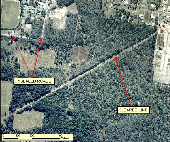
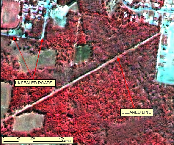
- In Figure 2.5.1.1a the Cleared Lines (created fire breaks, seismic monitoring, etc) have numerous attributes that differ to roads:
- They are generally wider and straighter.
- They have no pavement or bitumen.
- There are generally no roads diverging off them.
- There are generally no access points along these lines to buildings, dwellings or other infrastructure.
|
| Regional Considerations: |
|
| Figure: 2.5.1.1 Representation of Cleared Lines Vs Roads |
[back to top]
2.5.1.2 Example 2
| |
| Location of Example: |
141°50'04" East, 27°54'22" South |
| Distinctive Characteristics: |
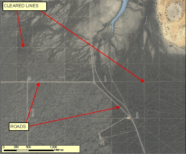
- Figure 2.5.1.2 is a representation of Cleared Lines in a Remote Area (created for fire breaks, seismic monitoring, etc).
- Cleared lines have numerous attributes that differ from roads:
- They are generally straighter and can sometimes form a rectilinear pattern.
- They have no pavement or bitumen.
- There are generally no roads diverging off them.
- There are generally no access points along these lines to buildings, dwellings or other infrastructure.
- Cleared lines may also show signs of overgrowth if not accessed recently.
|
| Regional Considerations: |
|
| Figure: 2.5.1.2 Representation of Cleared Lines Vs Roads |
[back to top]
2.5.2 Cultivated Areas
2.5.2.1 Example 1
| |
| Location of Example: |
152°17'51" East, 24°48'37" South |
| Distinctive Characteristics: |
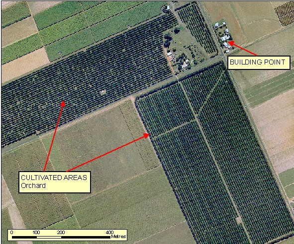
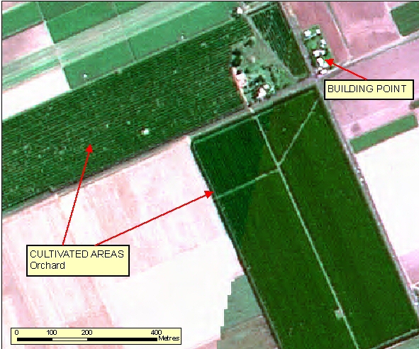
- Orchards can be identified by their orderly planting and contrast with the surrounding vegetation growth.
- Orchards have farm infrastructure associated with them.
- No significant vehicle tracks are generally visible through this area.
|
| Regional Considerations: |
- Orchards visibility on imagery vary depending on the season. eg. Apple trees in Autumn.
|
| Figure: 2.5.2.1 Representation of Orchards in association with surrounding features. |
[back to top]
2.5.2.2 Example 2
| |
| Location of Example: |
152°36'50" East, 25°22'29" South |
| Distinctive Characteristics: |
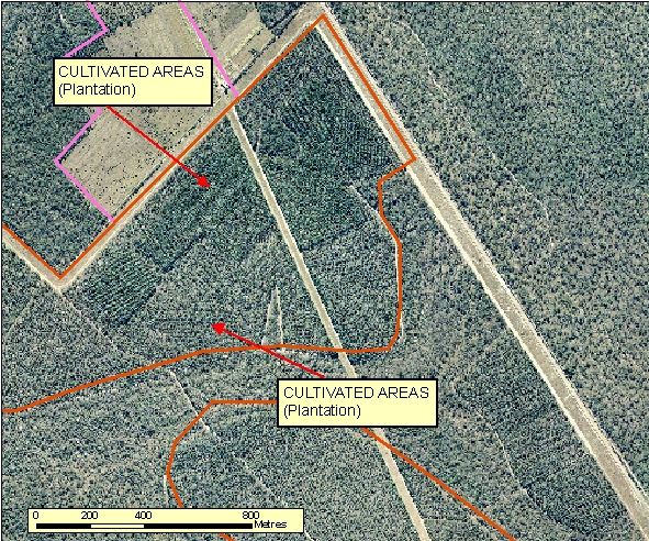
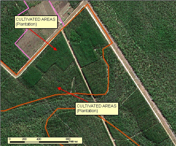
- Pine plantation can be distinguished by the tightly compacted rows of trees.
- Figure 2.5.4.1b shows both the newly planted rows, against the mature grown area, which is shown in dark green.
|
| Regional Considerations: |
|
| Figure: 2.5.2.2 Representation of Plantations in association with surrounding features. |
[back to top]
2.5.3 Cotton Gins
2.5.3.1 Example 1
| |
| Location of Example: |
149°33'42" East, 28°37'13" South |
| Distinctive Characteristics: |
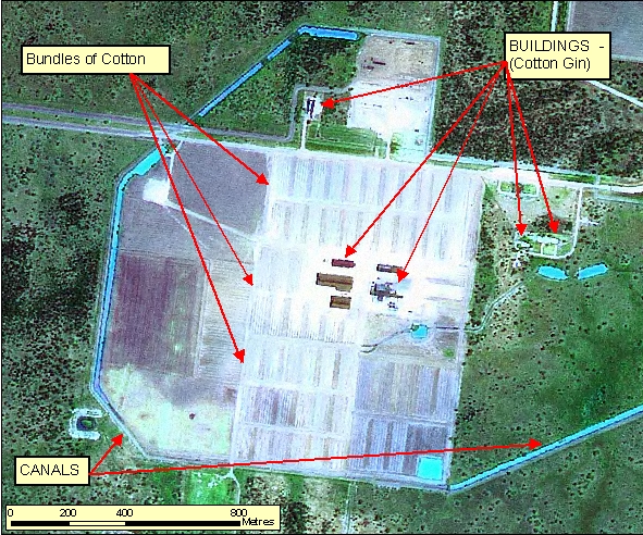
- The Cotton Gin facility has distinctive rectangular bundles of cotton during harvesting that are not topographic features and should not be captured.
- Related infrastructure such as Buildings and Canals can be captured.
|
| Regional Considerations: |
|
| Figure: 2.5.3.1 Representation of a Cotton Gin in association with surrounding features. |
[back to top]
2.5.3.2 Example 2
| |
| Location of Example: |
149°35'22" East, 29°26'22" South |
| Distinctive Characteristics: |
- The Cotton Gin facility has distinctive rectangular bundles of cotton during harvesting that are not topographic features and should not be captured.
- Related infrastructure such as Buildings and Canals can be captured.
|
| Regional Considerations: |
|
| Figure: 2.5.3.3 Representation of a Cotton Gin in association with surrounding features. |

[back to top]
2.5.3.3 Example 3
| |
| Location of Example: |
|
| Distinctive Characteristics: |
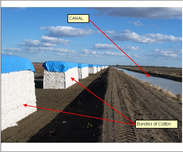
- Regular shaped Bundles of Cotton aligned on Cotton Gin.
- Note the tarpaulin covering the bundles. These covers cause bright white signatures on multispectral imagery.
|
| Regional Considerations: |
|
| Figure: 2.5.3.3 Photograph of Cotton Bundles |
[back to top]
2.5.4 Windbreaks
2.5.4.1 Example 1
| |
| Location of Example: |
149°20'42" East, 28°31'07" South |
| Distinctive Characteristics: |
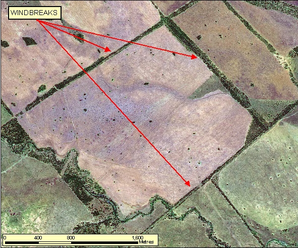
- Windbreaks are located within paddocks. Windbreaks are not remnant vegetation along road corridors.
- Remnant vegetation along road corridors must not be depicted as Windbreaks.
|
| Regional Considerations: |
- Windbreaks typically occur in relatively flat, open regions of agricultural production where strong prevailing winds can have a destructive impact.
|
| Figure: 2.5.4.1 Representation of Windbreaks in association with surrounding features. |
[back to top]
2.5.4.2 Example 2
| |
| Location of Example: |
149°20'42" East, 28°31'07" South |
| Distinctive Characteristics: |
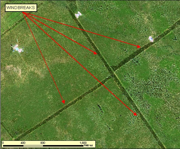
- Windbreaks are located within paddocks. Winbreaks are not remnant vegetation along road corridors.
- Remnant vegetation along road corridors must not be depicted as Windbreaks.
|
| Regional Considerations: |
- Windbreaks typically occur in relatively flat, open regions of agricultural production where strong prevailing winds can have a destructive impact.
|
| Figure: 2.5.4.2 Representation of Windbreaks in association with surrounding features. |
Topic contact: mapfeedback@ga.gov.au Last updated: January 20, 2012


