News 30 years on – Commemorating the 1989 Newcastle Earthquake
Last updated:7 June 2023

The 1989 Newcastle earthquake
At 10.27am on Thursday, 28 December 1989, Newcastle was devastated by an ML 5.6 (MW 5.4) earthquake. This was one of the most significant natural disasters in Australia's history.
- The epicentre was approximately 15 km SW of the Newcastle CBD (near Boolaroo) and the focus was calculated to be at a depth of about 11 km
- The earthquake claimed 13 lives: nine people died at the Newcastle Workers Club, three people were killed along Beaumont Street in Hamilton, and one person died of shock
- 300,000 people were affected and 1,000 were made homeless
- 50,000 buildings were damaged (approximately 35,000 of these were homes)
- 300 buildings were demolished
- 160 people required hospitalisation, while the Royal Newcastle Hospital was evacuated
- It left a damage bill estimated over $4 billion (Insurance Council of Australia) - normalised to 2017 values
- The effects were felt over an area of about 200,000 sq. km, with isolated reports of shaking felt up to 800 km from Newcastle
- Damage to buildings and facilities occurred over a 9000 sq. km region, an area equivalent to over 160 times the size of the Sydney Harbour
- The damage was most severe on soft sediments from the Hunter River, with shaking intensity of MMI VIII observed at many locations
- One aftershock (ML 2.1) was recorded on 29 December 1989
(Source: Newcastle Library and others)
If the earthquake had happened later in the evening, the number of casualties could have been much higher as thousands of people were expected to attend a Split Enz concert at the Newcastle Workers Club. It was also fortunate that, being a few days after Christmas, many heavily damaged education facilities were unoccupied at the time of the earthquake.
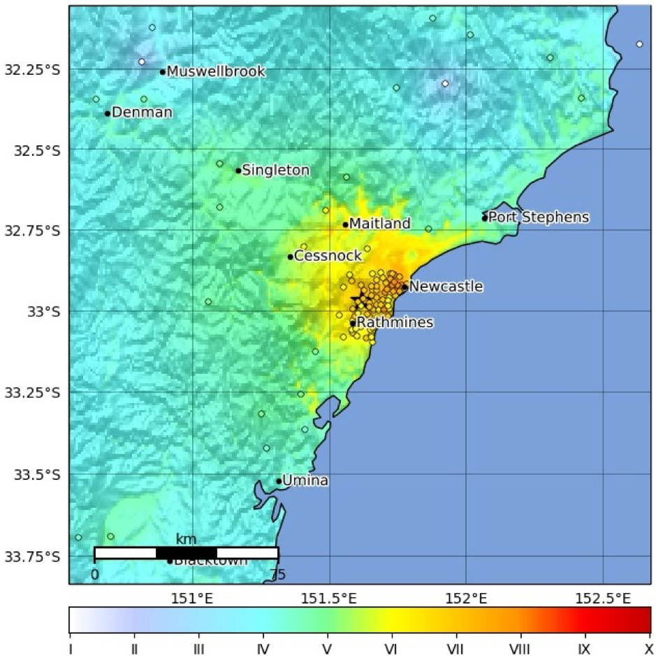
A "ShakeMap" showing the estimated shaking intensity (in "ShakeMap" was calculated using software developed by the U.S. Geological Survey. It integrates predictions of earthquake ground-shaking from theoretical models and MMI observations from the 1989 Newcastle earthquake

Mapped MMI data points following the 1989 MW 5.4 Newcastle earthquake. The MMI observations were digitised from the Atlas of Isoseismal Maps of Australian Earthquakes
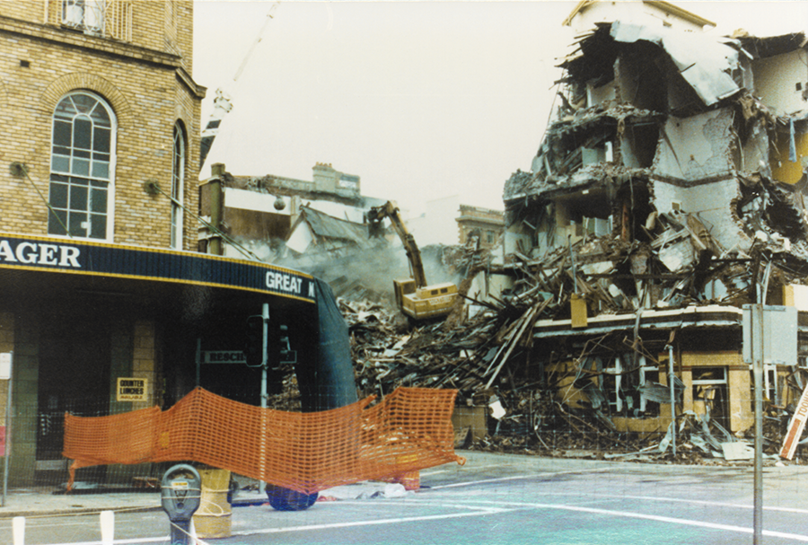
Damage from the 1989 Newcastle earthquake
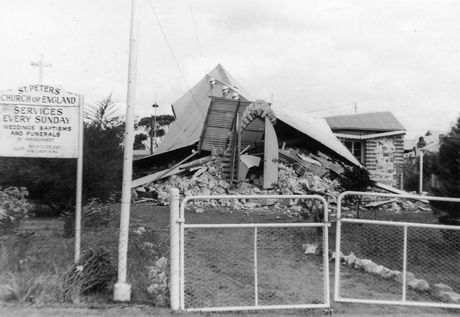
Damage from the 1989 Newcastle earthquake
What are earthquakes?
What is an earthquake?
An earthquake is the sudden release of energy and ground shaking resulting from rocks breaking and moving along a fault line under stress from plate tectonic forces. The focus is the initiation point of the earthquake deep within the Earth, while the epicentre is the vertical projection of the focus on the Earth’s surface. Earthquakes most commonly occur near the boundaries of tectonic plates, such as around the “Pacific Rim of Fire.” However, they can also occur within stable tectonic regions, like Australia. It is important to remember that large earthquakes can occur anywhere in Australia, and without warning, even in regions of low levels historical seismicity.
How do we measure earthquakes?
- Earthquakes are detected by instruments called seismometers
- Geoscience Australia operate a network of about 100 seismometers located around Australia
- Seismometers measure the intensity and duration of ground shaking (i.e., seismic waves) generated by an earthquake
- The arrival times of these seismic waves detected at three or more seismometers, and the speed at which they travel, are used to determine the location of the earthquake
Earthquake Magnitude
- The size of an earthquake (or its magnitude) is related to the energy released when the fault ruptured
- As magnitude increases, the strength of ground shaking, duration, and area impacted increases very quickly:
- Ground shaking increases by 10 times for every whole magnitude unit
- Energy released increases by 32 times for every whole magnitude unit
- Shaking duration increases from a few seconds (M 4) to several minutes (M 9)
- Several different magnitude scales can be used to determine the size of earthquakes. The two most common are:
- the local (replacing the old Richter) magnitude scale, which uses the largest shaking amplitudes measured at seismometers, ML
- the moment magnitude scale, which uses the whole shaking record to give a better estimate of the total energy released by the earthquake, MW
- In Australia, calculated moment magnitudes are commonly smaller than local magnitudes by about 0.2-0.3 magnitude units because they measure different physical parameters of the earthquake. Moment magnitudes, whilst a better measure of an earthquake’s size, require data that isn’t always available. For this reason, not all Australian earthquakes have estimates of MW.
Magnitude vs Intensity
- Earthquake magnitude is related to the energy released over its ruptured fault area
- The intensity of an earthquake refers to the level of ground-shaking at a given location
- Earthquake intensity decreases with increasing distance away from an earthquake
- The Modified Mercalli Intensity (MMI) scale is commonly used to describe the damage and felt effects of an earthquake at a given location
- MMI is a qualitative assessment of earthquake effects on structures and people
- Earthquake magnitude is a quantitative measure based on physical recordings made on seismometers
| Intensity | Shaking | Description/Damage |
|---|---|---|
| I | Not felt | Not felt except by a very few under especially favorable conditions. |
| II | Weak | Felt only by a few persons at rest,especially on upper floors of buildings. |
| III | Weak | Felt quite noticeably by persons indoors, especially on upper floors of buildings. Many people do not recognize it as an earthquake. Standing motor cars may rock slightly. Vibrations similar to the passing of a truck. Duration estimated. |
| IV | Light | Felt indoors by many, outdoors by few during the day. At night, some awakened. Dishes, windows, doors disturbed; walls make cracking sound. Sensation like heavy truck striking building. Standing motor cars rocked noticeably. |
| V | Moderate | Felt by nearly everyone; many awakened. Some dishes, windows broken. Unstable objects overturned. Pendulum clocks may stop. |
| VI | Strong | Felt by all, many frightened. Some heavy furniture moved; a few instances of fallen plaster. Damage slight. |
| VII | Very strong | Damage negligible in buildings of good design and construction; slight to moderate in well-built ordinary structures; considerable damage in poorly built or badly designed structures; some chimneys broken. |
| VIII | Severe | Damage slight in specially designed structures; considerable damage in ordinary substantial buildings with partial collapse. Damage great in poorly built structures. Fall of chimneys, factory stacks, columns, monuments, walls. Heavy furniture overturned. |
| IX | Violent | Damage considerable in specially designed structures; well-designed frame structures thrown out of plumb. Damage great in substantial buildings, with partial collapse. Buildings shifted off foundations. |
| X | Extreme | Some well-built wooden structures destroyed; most masonry and frame structures destroyed with foundations. Rails bent. |
Source: https://www.usgs.gov/
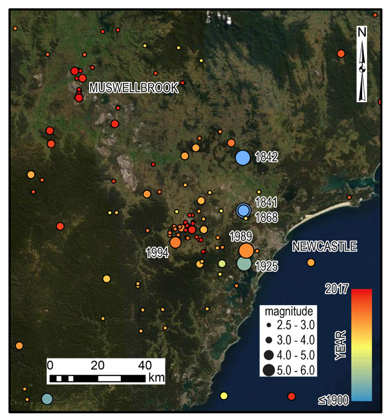
Historical Earthquakes in the Hunter Valley Region
Hunter Valley earthquake history
The Hunter Valley region has a long history of earthquakes in the written record, with the earliest occurring in the 1840s. Since this time, the region has experienced five earthquakes of magnitude 5.0 or larger; the most recent being a magnitude ML 5.1 (MW 4.7) earthquake near Ellalong in August 1994.
Where we are now
What kind of measures does Australia have in place in the event of an earthquake?
It is impossible to accurately predict exactly when and where an earthquake will occur, but the history of earthquake activity in a region can tell us a lot about its potential risk for future earthquakes. Geoscience Australia operates and maintains the Australian National Seismograph Network to provide the emergency management sector and the public with rapid notification of Australian earthquakes of magnitude 3.5 or greater, through the National Earthquake Alert Centre (NEAC). The NEAC also alerts on smaller earthquakes within Australia that have been felt.
In order to minimise the impact of future earthquakes, Geoscience Australia develops the National Seismic Hazard Assessment. This assessment identifies regions across Australia that are more or less likely to experience potentially damaging earthquake ground shaking. This information is important for risk management and decision making by the public, industry and government, and is used to improve building codes and standards. However, it is important to remember that large earthquakes can occur anywhere in Australia, and without warning, even where the mapped earthquake hazard may be low.
What is Geoscience Australia doing to improve our understanding of the earthquake hazard?
Geoscience Australia is integrating data and information from a variety of sources to learn more about earthquakes in Australia. Field mapping and satellite observations following moderate-to-large magnitude earthquakes can tell us about the extent and effects of ground deformation. Following the Newcastle earthquake, information was collected from around Newcastle and Lake Macquarie to better understand the local geology and susceptibility of the area to ground shaking. This information is being used to better inform land-use planning and building standards in the chance of future damaging earthquakes in the area.
More broadly, geological mapping can also teach us a lot about how very large pre-historical earthquakes have affected the landscape in which we now live, and how they have the potential to do so again in the future. Understanding the extent of an earthquake rupture gives us information on possible damage this deformation could pose to buildings and buried infrastructure (i.e. pipelines), should a similar sized earthquake reoccur nearer to populated areas.
Additionally, seismic data recorded throughout the Australian National Seismograph Network, together with data from temporary seismometer deployments, provides important information on how the strength of ground shaking decays with increasing distance away from an earthquake. With this information, we can develop models that can forecast the potential shaking intensities for larger earthquakes over a wide area. Geoscience Australia uses citizen science to help calibrate these models by using data submitted through the online reporting system. Members of the public can submit a report if they have felt an earthquake via earthquakes.ga.gov.au. Click on “I Felt This Earthquake” and fill out a short questionnaire. All of this information gets fed into regular updates of the National Seismic Hazard Assessment, which allows decision makers to design the built environment, and prepare communities for future earthquakes.
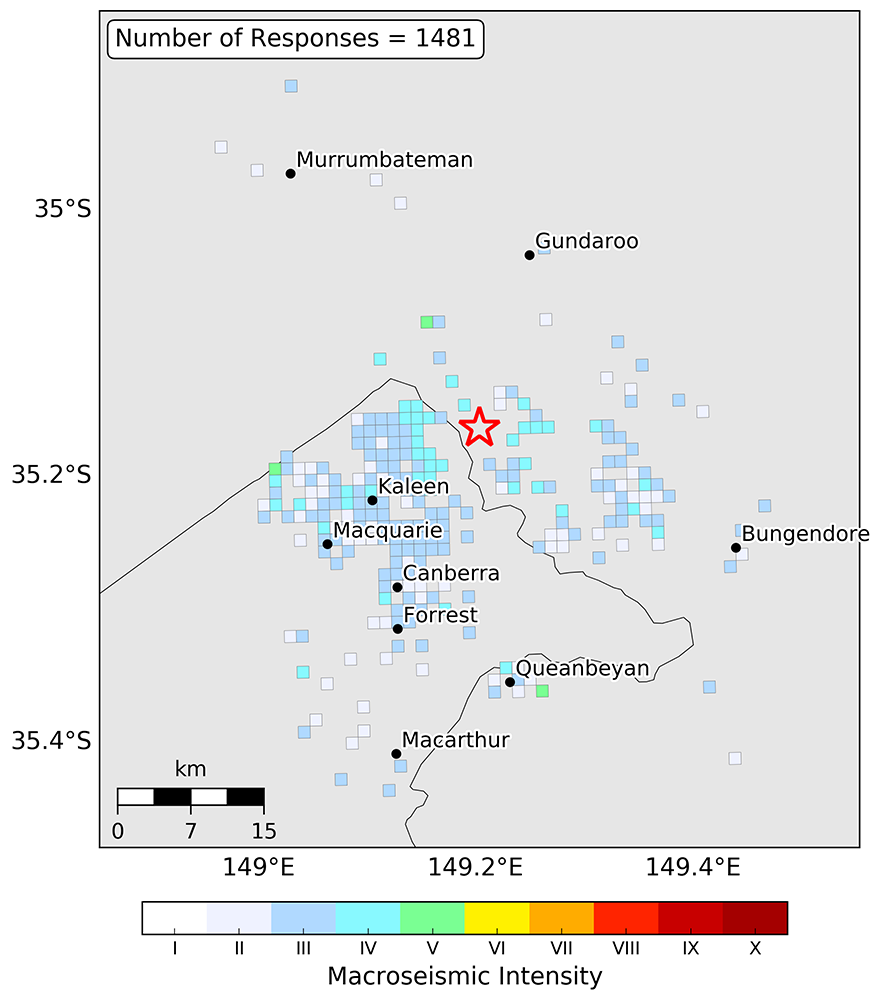
Citizen science in action! Felt reports following the 17 January 2019 (UTC time) ML 3.1 earthquake near Sutton, NSW
Resources
- Go to earthquakes.ga.gov.au to find information on recent earthquakes as monitored by Geoscience Australia, search the earthquake catalogue, submit a report about an earthquake you have felt, and subscribe to notifications about earthquakes Geoscience Australia has analysed.
- Visit our Community Safety website for more information about earthquakes
- An interactive history of Australian Earthquakes can be found in Geoscience Australia’s Earthquake Storymap.
- In 2018, Geoscience Australia released a new National Seismic Hazard Assessment for Australia – the NSHA18. The NSHA defines the level of earthquake ground shaking across Australia that has a likelihood of being exceeded in a given time period. Knowing how the ground-shaking hazard varies across Australia allows higher hazard areas to be identified for the development of mitigation strategies so communities can be more resilient to earthquake events. The NSHA18 is freely accessible and available to download. A one-hour seminar about the NSHA18 is available.
- Watch and learn how to stay safe during any situation with the Earthquake Safety Video Series.
- The Newcastle Museum is running the “Then and Now Again – 30 Years” exhibition from July 2 2019 to October 27 2019. This is a photographic exhibition first run in 2014 (commemorating the 25 year anniversary), replicating photos from the time and asking the people in the photos what their earthquake experience was like and what had changed in their life over the past 25 years.
- The Newcastle Herald ran a “Quake memories: city remembers fateful day” article in December 2014 (commemorating the 25 year anniversary), in which the journalist, Greg Ray, provides a moving recount of his own experience of the event, lists detailed facts about the earthquake impacts, and provides a list of the deceased.
- Destructive earthquakes can happen in Australia and when they do, they can have significant impacts on communities. The series of YouTube videos below demonstrates some of these impacts. These videos are NBN TV Australia footage from the Newcastle Earthquake aftermath, hosted on the Newcastle Museum YouTube channel.