


Adelaide Hills fires image captured by Landsat 8 satellite
7 January 2015
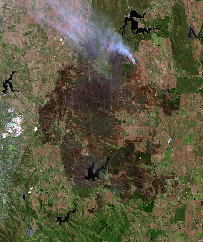
Adelaide Hills fires image captured
by Landsat 8 satellite at 11:30am
(AEDT) on 4 January 2015.
Fires continue to burn across parts of South Australia as the heatwave emanating from central Australia raises temperatures in the region.
This satellite image of the Adelaide Hills fires taken at 11:30am on 4 January, from the United States Geological Survey Landsat 8 satellite, shows the active fire front at the top-right of the image, appearing red with white smoke plumes.
Burnt areas appear as dark brown below the fire front. Light brown areas are dry grass, while greens indicate crops, forests and irrigated areas. Several large reservoirs appear as black.
Geoscience Australia also uses satellites to map 'hotspots' which are delivered through the Sentinel application.
For more information on the South Australian fires visit the South Australian Country Fire Service website or call 1300 362 361.
Download the high resolution image [JPEG 5MB]
![Download the high resolution image [JPEG 5MB]](https://www.ga.gov.au/__data/assets/image/0009/26487/Adelaide-Hills-Fires-high-res.jpg)
Image produced by Geoscience Australia using data acquired from the United States Geological Survey Landsat 8 Satellite.