


Australian continent uncovered by new 3D model

19 February 2015
Liejun Wang and Adrian Hitchman
This Insights article is an overview of the poster presented by Geoscience Australia's Liejun Wang at the 24th International Geophysical Conference and Exhibition in Perth, 13-18 February 2015.
You need to upgrade your browser and have javascript enabled to view this video.
Models derived from geophysical properties of rocks are an important source of information about the geological structure hidden below the Earth's surface. Australia is fortunate to be the sole occupant of a single continent and provides the perfect laboratory for continental-scale studies of these geophysical properties.
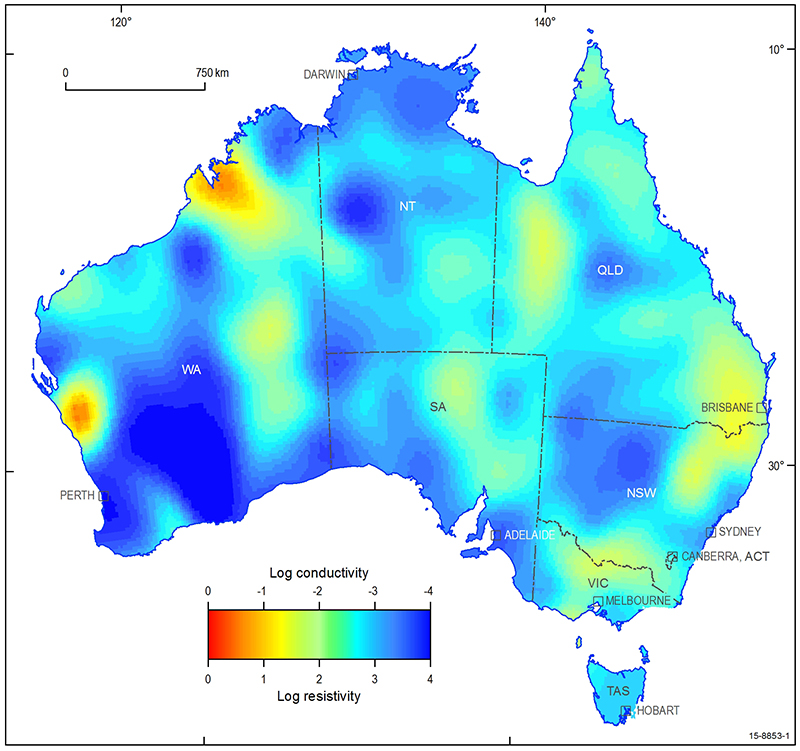
Image at depth of 112km from the 3D
model showing the electrical properties
of the Australian continent.
The Australia-wide Array of Geomagnetic Stations 1, 2 (AWAGS) collected data for a range of scientific uses including space weather, magnetic-direction finding, compass-based navigation and resource exploration. Using these data we present a new 3-dimensional model of the electrical structure of the Australian continent, offering insights that will refine understanding of the continent's evolution and mineral and petroleum prospectivity. This is important, as it further increases industry's confidence to invest in exploration.
The analysis identifies new electrical structures in the upper mantle, helping us to better understand the underlying geological structure in the deepest regions of the Australian continent. At shallow depths, the new model shows crustal conductivity anomalies that are consistent with those previously mapped by independent magnetometer array studies.
Building upon historical studies
Magnetometers have been acquiring data since the 1950s at more than 600 sites across Australia to study the electrical structure of the geology. Research in the 1990s compiled these data into continent-wide datasets and used forward and later inverse modelling techniques to derive early models of the electrical structure of the continent.
AWAGS was the first example of the evolution of magnetometer array studies from local and regional scales to continent scale 2. The AWAGS data recorded 3-component magnetic time-series simultaneously at 53 temporary sites and 4 geomagnetic observatories during 1989-90 and is a milestone study in respect to its coverage and impact on geoelectric studies.
The computing power and modelling capabilities available at this time necessitated representing the modelled geology as a thin sheet of pre-determined depth (e.g. 10 kilometres) and using only a subset of the data from each station. The resulting models possessed reasonable horizontal resolution but lacked reliable depth resolution; they were effectively 2.5D. These innovative but rudimentary models, however, demonstrated how magnetic-field data could be applied to understand the broad-scale electrical structure of the continent.
Key features of the continental model
Crustal conductivity anomalies represented in the continental model are consistent with those individually mapped by local magnetometer array studies. The model provides information that sets these local anomalies in a wider regional context. For example, a previously identified anomaly in the Canning Basin in northern Western Australia appears to be more complex than previously defined; it is possibly associated with a deeper more conductive anomaly. The new model also suggests there is no connection between the Canning Basin anomaly and another in Queensland as previously suggested 3.
The model also identifies several new conductivity anomalies located in the upper mantle. Two of these have been investigated by recent magnetotelluric surveys, one in the Yilgarn Craton-Officer Basin-Musgrave Block 4, the other in the Gawler Craton region 5. The new model and the magnetotelluric results give consistent indications of the location, depth and magnitude of the conductivity anomalies.
Conductivity differences are also observed beneath Archean cratons in Western Australia. The Pilbara Craton is represented as a mid-lithosphere enhanced-conductivity anomaly. The Yilgarn Craton is imaged as a resistive body continuing to greater depths. An enhanced-conductivity layer is also observed at middle-lithosphere depths across much of central Australia.
Future potential applications
This model is the first fully seamless 3D representation of the electrical properties of the Australian continental geology. It corroborates some features identified by earlier local and regional studies and also suggests new features not previously modelled, adding new information to the study of Australian geology. The model is a stepping stone to higher-resolution models derived from higher-frequency data gathered at more closely spaced stations.
For example, the AusLAMP study 6, which is currently collecting magnetotelluric data on a 55 kilometre grid across the continent, promises a quantum leap in understanding the electrical properties of Australia's geology. This study will provide important information about Australia's geodynamic framework and pre-competitive data for resource exploration.
References
[1] ^ Wang, L., Hitchman, A.P., Ogawa, Y., Siripunvaraporn, W., Ichiki, M. & Fuji-ta, K., 2014. A 3D conductivity model of the Australian continent using observatory and magnetometer array data, Geophysical Journal International, 198, 1143-1158.[2] ^ Chamalaun, F.H. & Barton, C.E., 1990. Comprehensive mapping of Australia's geomagnetic variations, Eos, Transactions American Geophysical Union, 71, 1867.
[3] ^ Chamalaun, F.H. & Barton, C.E., 1993. Electromagnetic induction in the Australian crust: results from the Australia-wide Array of Geomagnetic Stations, Exploration Geophysics, 24, 179-186.
[4] ^ Duan, J., Milligan, P.R. & Fomin, T., 2013. Electrical resistivity distribution from magnetotelluric data in the Yilgarn Craton, western Officer Basin and western Musgrave Province, in Yilgarn Craton-Officer Basin-Musgrave Province Seismic and MT Workshop, pp. 9-23, ed. Neumann, N.L., Geoscience Australia Record, 2013/28. 9677
[5] ^ Thiel, S. & Heinson, G., 2013. Electrical conductors in Archaean mantle-Result of plume interaction?, Geophysical Research Letters, 40, 2947-2952.
[6] ^ Stolz, N., 2013. New national magnetotelluric survey gets underway, AusGeo News, 112, Geoscience Australia.