


Dynamic topography of Australia's margins

30 May 2014
Dr Karol Czarnota
It is well known in the geosciences that most of the Earth's topography and bathymetry is a consequence of tectonic plates thinning or thickening along their boundaries. Since the Australian continent has been unaffected by tectonic boundaries since Gondwana broke up over 80 million years ago, its topography and bathymetry is generally viewed as old and stable.
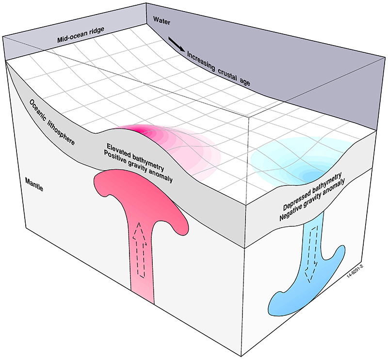
Figure 1: Diagram
showing the subsidence
of the ocean floor
as the oceanic plate
cools and thickens
with age.
In such regions the geological stratigraphic rock record is thought to simply reflect changes in global sea-level as opposed to the growth of new topography. In the last few years this view has been undergoing a rethink.
The geoscience community is beginning to realise that many broad topographic and bathymetric features in intra-plate settings, such as Australia, are the surface expression of convective circulation within the Earth's mantle. It has long been expected that above rising, hot and buoyant material within the mantle a broad topographic swell will develop [1].
Conversely, the presence of sinking, cool and dense material within the mantle should lead to a wide topographic depression at the Earth's surface. These broad topographic features are expected to come and go as tectonic plates drift across an ever-changing pattern of convective circulation beneath them. Until recently the significance and geological expression of this phenomenon, known as dynamic topography, has eluded the geoscience community because it has been difficult to measure its effects.
Over the last four years Geoscience Australia in partnership with the University of Cambridge has measured dynamic topography around Australia and begun to unravel its history from the stratigraphic record along its margins.
Mapping dynamic topography
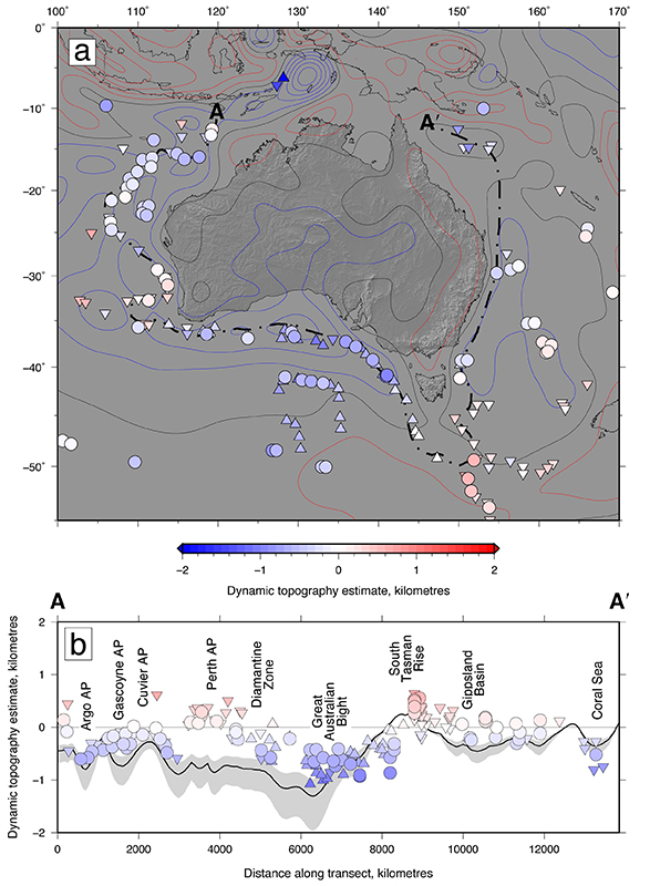
Figure 2: Oceanic dynamic
topography estimates.
Dynamic topography is best mapped in the oceans where bathymetry arising from changes in plate thickness can easily be accounted for. On average the oceanic floor is 2.6 kilometres deep at mid-ocean ridges and subsides to 5.7 kilometres as the plate cools and thickens with age [2]. Departures from this well-established trend are used to map dynamic topography [Figure 1]. The results show that dynamic topography varies by up to 1 kilometre across distances of thousands of kilometres. The Great Australian Bight is drawn down by up to 1 kilometre and the North West Shelf and the Coral Sea are down by up to 700 metres. In contrast, the Perth Abyssal Plain and the South Tasman Rise are elevated, above the oceanic age-depth trend, by a few hundred metres [Figure 2]. In most regions this variation can be predicted using gravity data with the exception of the Perth Abyssal Plain [3].
Growth of dynamic topography through time
In northern Australia the stratigraphic record along the North West Shelf of Australia reveals that the onset of dynamic drawdown occurred approximately 10 million years ago. Up to 700 metres of subsidence has occurred since then which is seven times the amount that can be accommodated by global sea-level change.
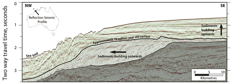
Figure 3: Sedimentary stacking
patterns imaged using
a reflection seismic profile.
Carbonate rocks stopped being deposited progressively further out to sea and started to be stacked on top of one another as the continental shelf was drowned by a relative rise in sea level [Figure 3]. This change in stratigraphic stacking pattern played a very important part in shaping the petroleum system of the Browse Basin, triggering the expulsion of approximately 50% of the basin's oil. Consequently it is the interaction of surficial and deep earth processes that shaped the region's hydrocarbon endowment.
In southern Australia, 300 metres of dynamic uplift over the last 40 million years has exposed the Nullarbor Plain and formed spectacular cliffs along its southern edge [Figure 4].
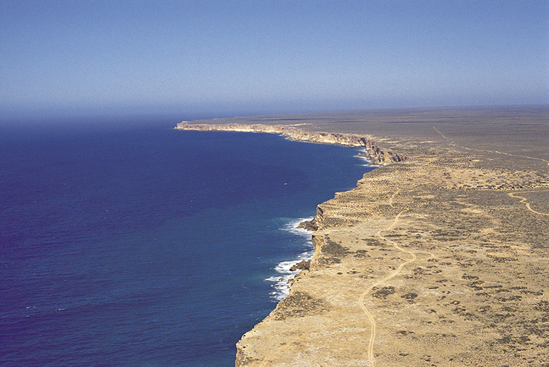
Figure 4: The Nullarbor Plain - an
example of dynamic uplift.
Photographer: Neale Winter.
Copyright: South Australian Tourism
Commission.
This uplift is a consequence of the Australian Plate drifting northwards out of the dynamic depression affecting the Great Australian Bight and Southern Ocean [4], [5].
Ongoing research is yielding tremendous insights into the evolution of Australia's dynamic topography. These insights provide geoscientists working on site-specific problems the context and confidence to understand landscape and basin evolution controlled by processes that operate at the continental scale yet profoundly affect the geology at the local scale. These observations also afford hitherto inaccessible insights into the pattern of convective circulation within the mantle.
For an in-depth treatment of this work see other publications by Czarnota et al. [3], [5].
References
[1] ^McKenzie, D., J. Roberts, and N. Weiss (1973), Numerical Models of Convection in Earths Mantle, Tectonophysics, 19(2), 89-103.
[2] ^Crosby, A. G., D. McKenzie, and J. G. Sclater (2006), The relationship between depth, age and gravity in the oceans, Geophysical Journal International, 166(2), 553-573.
[3] ^Czarnota, K., M. J. Hoggard, N. White, and J. Winterbourne (2013), Spatial and temporal patterns of Cenozoic dynamic topography around Australia, Geochemistry, Geophysics, Geosystems, 14(3), 634-658.
[4] ^Sandiford, M. (2007), The tilting continent: A new constraint on the dynamic topographic field from Australia, Earth and Planetary Science Letters, 261(1-2), 152-163.
[5] ^Czarnota, K., G. G. Roberts, N. J. White, and S. Fishwick (2014), Spatial and temporal patterns of Australian dynamic topography from River Profile Modeling, Journal of Geophysical Research: Solid Earth, 119(2), 1384-1424.