


Researchers defrost on return from Casey Station
13 April 2015
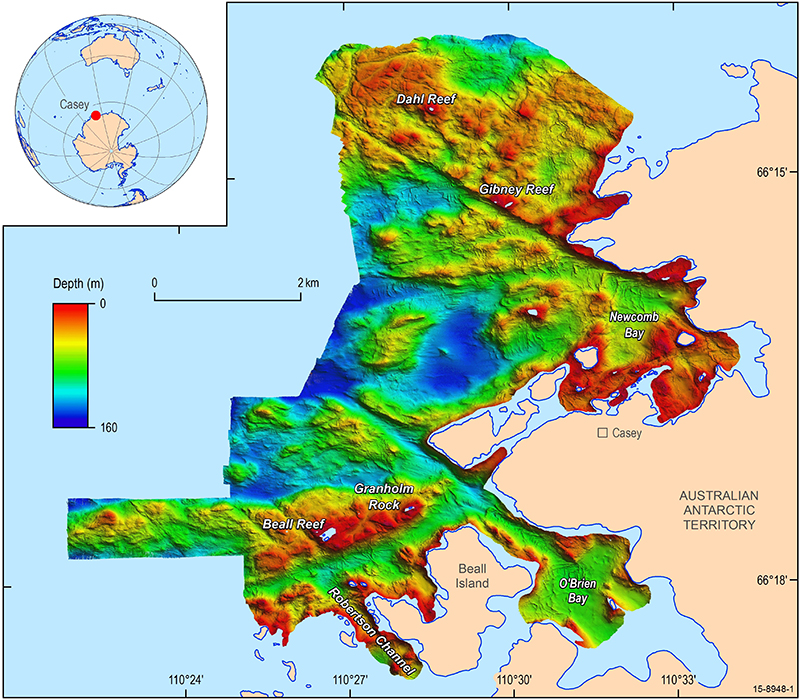
New high resolution bathymetry
data obtained in the relatively shallow
waters around Casey station.
Geoscience Australia and Royal Australian Navy researchers have recently returned from a summer mapping the Antarctic waters around Casey Station in unprecedented detail.
The survey, carried out between December 2014 and February 2015 used multibeam sonar equipment mounted upon the Australian Antarctic Division's science workboat, the RV Howard Burton, to obtain high resolution bathymetry data in the relatively shallow waters around Casey station.
The bathymetry data, combined with imagery of the seafloor biological communities and sediment samples, has a wide range of potential applications to help inform better marine management and monitoring practices in Casey Harbour and surrounds. This information will also assist in expanding our understanding of the past extent of the Antarctic ice sheet, as well as providing clues to how the ice sheet may respond to environmental change in the future.
Dr Chris Carson, leader of Geoscience Australia's Antarctic Geoscience project, said this new data provides information on the shape of the seafloor in unprecedented detail, and will help improve understanding of these unique marine environments.
Dr Carson said preliminary interpretation of the data has identified several prominent geomorphological features of likely glacial origin on the sea floor.
"Initial analysis of the bathymetry data shows a series of narrow channels between 200 and 400 metres wide that appear to have been eroded and widened by glacial action. A significant clue is the typical 'U-shaped' profiles, similar to the glacially eroded valleys seen in terrestrial environments," he explained.
Geoscience Australia's marine geoscientists are now completing a full analysis of the datasets, including mapping the distribution and composition of seafloor habitats, which will help to build further understanding of the processes that have shaped the seafloor around Casey. The results are due for release later in 2015.
The latest findings build upon the ongoing collaboration between the Australian Antarctic Division and Geoscience Australia to support effective and informed environmental management within the Australian Antarctic Territory. This also demonstrates Australia's ongoing commitment to supporting the environmental principles of the Antarctic Treaty System.
The data will also help the Royal Australian Navy to develop more accurate up-to-date navigation charts, therefore reducing risk to maritime operations in the region.
Further information:
- Highlights article: Exploring the icy waters of Casey station