Mapping our World - Geocaching activity
Earth Science Week is an international event to raise awareness of the earth sciences. This year's theme is "Mapping our World" and will promote awareness of the many uses of maps and mapping technologies and ways that Earth scientists use maps to understand our planet.
Earth Science Week aims to engage young people and others in learning how geoscientists, geographers, and other mapping professionals use maps to represent land formations, natural resource deposits, bodies of water, fault lines, volcanic activity, weather patterns, travel routes, parks, businesses, population distribution, our shared geologic heritage, and more. Maps help show how the Earth's systems, such as geosphere, hydrosphere, atmosphere, and biosphere interact.
Earth Science Week was initiated by the American Geosciences Institute to promote the importance of the geosciences to the community.
Read more about Earth Science Week activities.
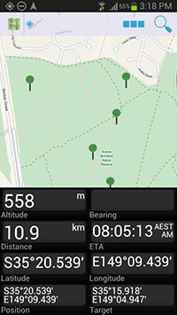
GPS coordinates
GEOCACHING for Earth Science Week
About GPS
Global Positioning System (GPS) devices receive signals broadcast from satellites. They then use these signals to determine their exact location on the Earth. When you load locational data into these devices, they'll guide you to where you want to go - most are accurate to within a few metres.
Geocaching is a worldwide scavenger hunt based on GPS coordinates. GPS-enabled devices used for geocaching can range from a smartphone all the way up to high-sensitivity handhelds that are bursting with special geocaching features. With basic models, you can enter coordinates by hand or download and input computer files, then print out accompanying clues and data. Higher-end GPS units allow you to download data directly to the device; many even offer "paperless geocaching" which allows everything you need to find the cache to be displayed right on the screen.
How geocaching works
Geocaching is a 21st century version of hide and seek. It is a real-world, outdoor treasure hunting game using GPS-enabled devices. Geocachers navigate to a specific set of GPS coordinates and then attempt to find a geocache (container) hidden at that location.
Coordinates consist of two numbers - the latitude and longitude - and although the GPS receiver will guide the geocacher to that location, the finder must still search for the geocache (this is what makes geocaching so exciting). Typically the geocache is hidden to ensure non-geocachers ("muggles") do not find it. After the geocache is found, the geocacher signs the logbook and may trade items in and out of the container. Typical cache "treasures" are not high in monetary value but may be interesting to the finder. Aside from the logbook, common cache contents are unusual coins or currency, small toys, ornamental buttons, CDs, or books.
Most geocaches are listed on Geocaching's website, but there are several other websites including Geocaching Australia.
What you need to get started
- A GPS device or download an app to a smartphone to work as a GPS. A recommended free app is GPS Essentials for Android smartphones or Free GPS for iPhones
- A friend
- Walking shoes
- Insect spray and sunscreen
- Extra GPS batteries
- Pen and notebook
- Camera
- Plenty of water
- Snack
- Something to leave behind in the caches if you want to take something.
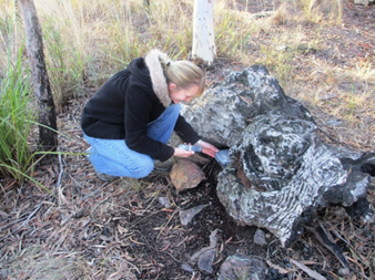
An example of where you may find a geocache.
To work out where local geocaches are hidden go to Geocaching, register as a basic member (free) and search for geocaches via the map. When you have found some nearby locations, print out the webpage which includes important information about the type of cache - traditional (these are the best ones for first time geocachers), multiple (one cache gives you a clue to another), virtual or mystery caches (no actual cache - just a destination with something interesting about it). The information will also include a rating of the difficulty and terrain, size of the item, the date placed, a short description and when it was last found by someone. If you have had difficulty finding the cache, don't be disappointed as the cache may have been taken, so think about looking for a different one.
To get ready for your caching adventure, ensure that you have the things listed on the previous page. A geocache can contain different objects, so that if it was for foreign currency, take some foreign coins to leave with the cache. Next, create waypoints in the GPS for the caches, using the latitude and longitude coordinates from the webpage.
Using the navigate feature (if using GPS Essentials - 'Set as Target' then 'Show on Map') to set your GPS to take you to the nearest geocache. Start walking towards the cache and watch the GPS to make sure that you are heading in the right direction. The most exciting thing about geocaching is watching the distance to your target get smaller and smaller. When you are within about 10 metres put the GPS away and rely on your eyes. You are looking for something that doesn't look quite 'right' - like an odd pile of rocks or sticks that would make a good hiding spot for a container.
A geocache is typically a waterproof container the size of a lunch box, but it may be as small as a match box or as large steel drum. After returning home log your cache finds on the website.

Another example of a geocache.
ACTIVITY: Tell us about your geocaching experience.
We are interested to hear about what you found on your geocaching adventure and tell us about your experience. Please send an email to education@ga.gov.au.
Geocaching in the classroom
Geocaching is a cross-curriculum activity which combines outdoor pursuit with team-building, problem-solving and other valuable educational outcomes. Learning about the theory behind geocaching and undertaking the activity can increase excitement and long term understanding.
However, it is important to never place public geocaches on school property. Educaching is similar to geocaching but the teacher hides the caches on a temporary basis (maybe in the school grounds or local community). Educaches normally contain challenges linked to learning outcomes and thematic learning.
Other ideas include:
Science
- Examine what a Global Positioning System is and how it works.
- Most geocaches are placed in a location that is interesting. An EarthCache is a special place that people can visit to learn about a unique geoscience features of our Earth. EarthCache pages include a set of educational notes along with cache coordinates. Visitors to EarthCaches can see how our planet has been shaped by geological processes, how we manage its resources and how scientists gather evidence to learn about the Earth. Visit EarthCaches for more information.
- Create a weather cache and include a thermometer, hygrometer and cloud chart. Ask people to log the date and time as well as weather conditions. You can also create caches to monitor creeks (include water testing strips). Data can then be graphed and interpreted.
- Make a botanical tour of your campus or local park marking the locations of different plants.
- Create a map or tour of different rock formations, with a description of each place visited.
Geography
- Place a geocache near your school or on a school excursion for the public (or the next year's cohort) to find.
- Create a private cache at your school and leave some newspapers from that year inside. Leave similar items each year and over time it will give perspective on past events.
- Compare using a GPS with other ways of navigating (with a compass, the stars). Have some students look for a cache using traditional orienteering whilst others use GPS devices. You may need to even the score a little by marking the exactly where the cache is on the orienteering map or by giving the orienteering group a head start.
- Develop a historical tour of your city or town using geocaches as points to visit.
- Create a "travel bug" on geocaching.com that can go from place to place and end up in a location relevant to your class or school.
- Use a GPS to find elevation and change in relief and compare to a topographic map.
Other resources: