2.1 Habitation and Associated Areas
2.1.1 Homesteads
2.1.1.1 Example 1
| |
| Location of Example: |
151°17'24" East, 27°39'27" South |
| Distinctive Characteristics: |
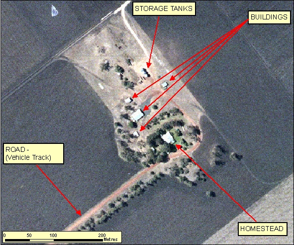
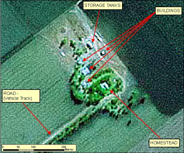
- Homesteads are characteristically surrounded by irrigated vegetation/gardens.
- In Figure 2.1.1.1a the Buildings appear as rectangular elevated features, this is evident by shadow signatures. The Storage Tanks have a more linear narrow appearance but still exhibit the elevated shadow signatures.
- In many cases the main access road to the Homestead may be lined with vegetation.
|
| Regional Considerations: |
|
| Figure: 2.1.1.1 Representation of a Homestead in association with surrounding features. |
[back to top]
2.1.1.2 Example 2
| |
| Location of Example: |
151°17'33" East, 27°37'55" South |
| Distinctive Characteristics: |
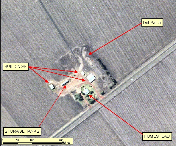
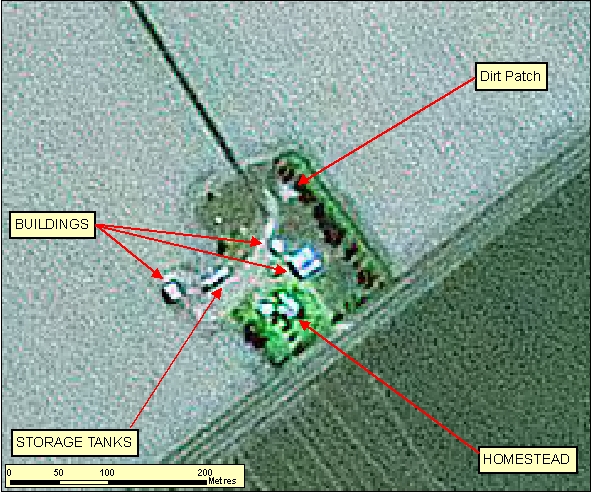
- In Figure 2.1.1.2a the Buildings appear as rectangular elevated features, this is evident by shadow signatures. The Storage Tanks have a more linear narrow appearance but still exhibit the elevated shadow signatures.
- In many cases the main access road to the Homestead may be lined with vegetation.
- The cleared/dirt patch does not exhibit any shadow signature and should not be captured mistakenly as a Building.
|
| Regional Considerations: |
|
| Figure: 2.1.1.2 Representation of a Homestead in association with surrounding features. |
[back to top]
2.1.2 Buildings
2.1.2.1 Example 1
| |
| Location of Example: |
152°45'35" East, 25°16'23" South |
| Distinctive Characteristics: |
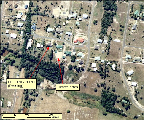
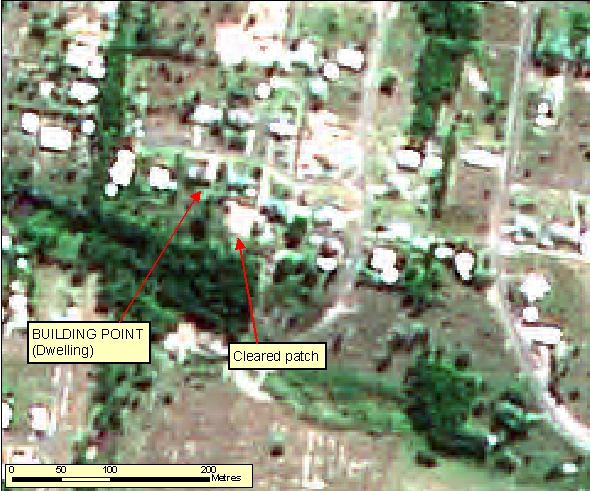
- Buildings can be distinguished by their right angled construction and shadow.
- Cleared/dirt patches do not exhibit any shadow signature and should not be captured mistakenly as a Building.
|
| Regional Considerations: |
|
| Figure: 2.1.2.1 Representation of Buildings in association with surrounding features. |
[back to top]
2.1.2.2 Example 2
| |
| Location of Example: |
152°40'01" East, 25°27'38" South |
| Distinctive Characteristics: |
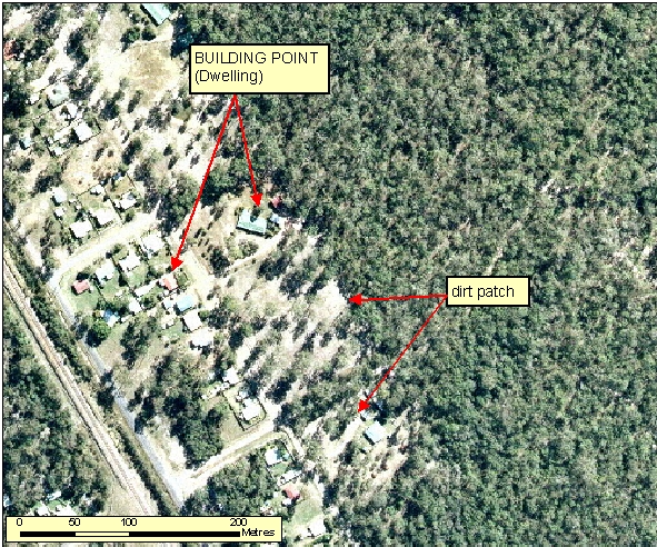
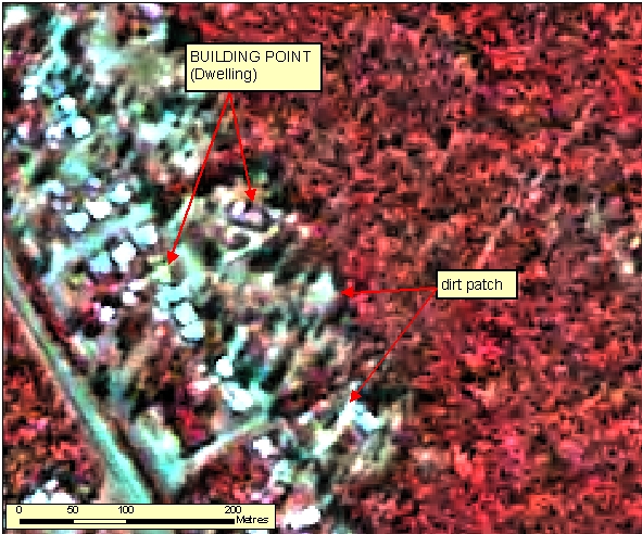
- Buildings can be distinguished by their right angled construction and shadow.
- Cleared/dirt patches do not exhibit any shadow signature and should not be captured mistakenly as a Building.
|
| Regional Considerations: |
|
| Figure: 2.1.2.2 Representation of Buildings in association with surrounding features. |
[back to top]
2.1.3 Schools
2.1.3.1 Example 1
| |
| Location of Example: |
152°50'43" East, 25°17'16" South |
| Distinctive Characteristics: |
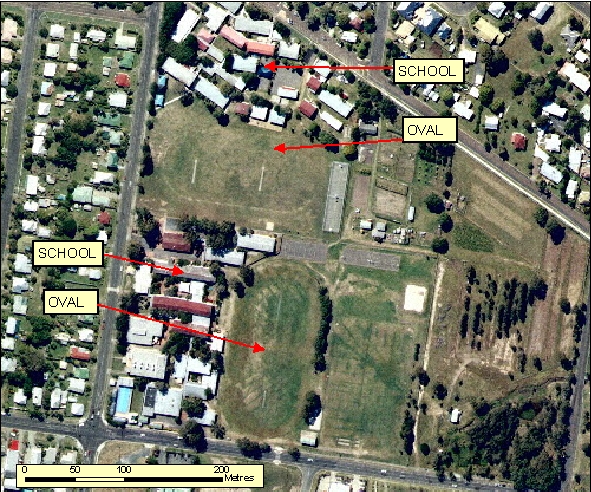
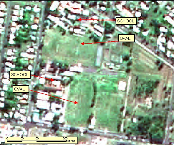
- School complexes within Built Up Areas are normally associated with playing fields. This combination of grouped Buildings and sporting fields distinguishes them from other complexes.
- School Buildings may be built over various eras making them distinguishable from surrounding Builtup only by size and proximity to playing fields as per example 1. Otherwise, all buildings can be built at the same time either as a distinct set of buildings or as inter connected buildings as per examples 2 and 4 respectively.
|
| Regional Considerations: |
- School complexes within urban and regional centres generally use a large land area which is reflective of the number of students eg 200 plus. Whereas schools in remote rural townships may only have 15 students and this will be reflected in the extent of land utilised by the school.
|
| Figure: 2.1.3.1 Representation of a School in association with surrounding features. |
[back to top]
2.1.3.2 Example 2
| |
| Location of Example: |
152°52'23" East, 25°18'22" South |
| Distinctive Characteristics: |
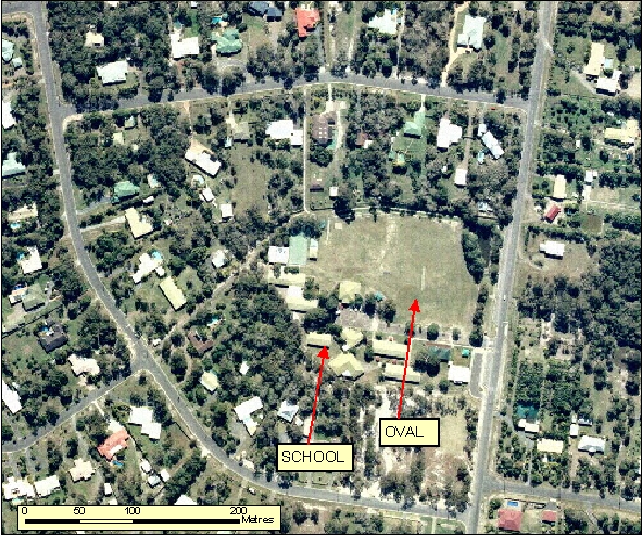
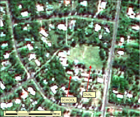
- School complexes within Built Up Areas are normally associated with playing fields. This combination of grouped Buildings and sporting fields distinguishes them from other complexes.
- School Buildings may be built over various eras making them distinguishable from surrounding Builtup only by size and proximity to playing fields as per example 1. Otherwise, all buildings can be built at the same time either as a distinct set of buildings or as inter connected buildings as per examples 2 and 4 respectively.
|
| Regional Considerations: |
- School complexes within urban and regional centres generally use a large land area which is reflective of the number of students eg 200 plus. Whereas schools in remote rural townships may only have 15 students and this will be reflected in the extent of land utilised by the school.
|
| Figure: 2.1.3.2 Representation of a School in association with surrounding features. |
[back to top]
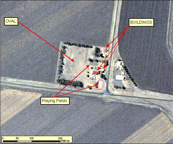
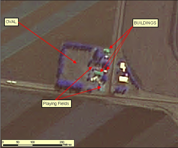
2.1.3.3 Example 3
| |
| Location of Example: |
151°26'41" East, 27°34'49" South |
| Distinctive Characteristics: |
- Generally rural school complexes are significantly smaller than their typical urban schools counterparts.
- The school's associated infrastructure, such as ovals and playing fields, can still be identified.
|
| Regional Considerations: |
- School complexes within urban and regional centres generally use a large land area which is reflective of the number of students eg 200 plus. Whereas schools in remote rural townships may only have 15 students and this will be reflected in the extent of land utilised by the school.
|
| Figure: 2.1.3.3 Representation of a School in association with surrounding features. |
[back to top]
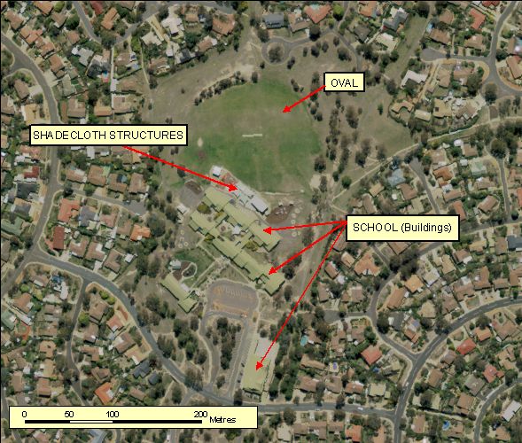
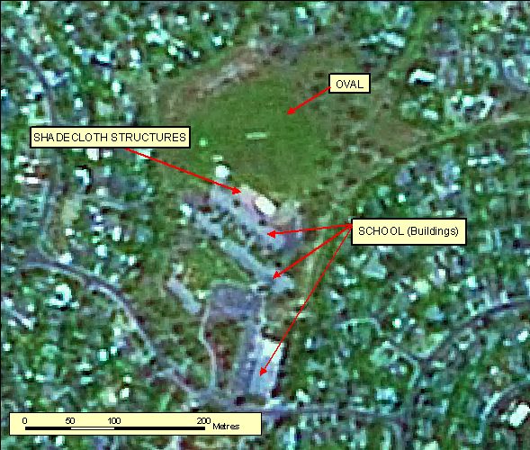
2.1.3.4 Example 4
| |
| Location of Example: |
149°07'06" East, 35°24'12" South |
| Distinctive Characteristics: |
- School complexes within Built Up Areas are normally associated with playing fields. This combination of grouped Buildings and sporting fields distinguishes them from other complexes.
- School Buildings may be built over various eras making them distinguishable from surrounding Builtup only by size and proximity to playing fields as per example 1. Otherwise, all buildings can be built at the same time either as a distinct set of buildings or as inter connected buildings as per examples 2 and 4 respectively.
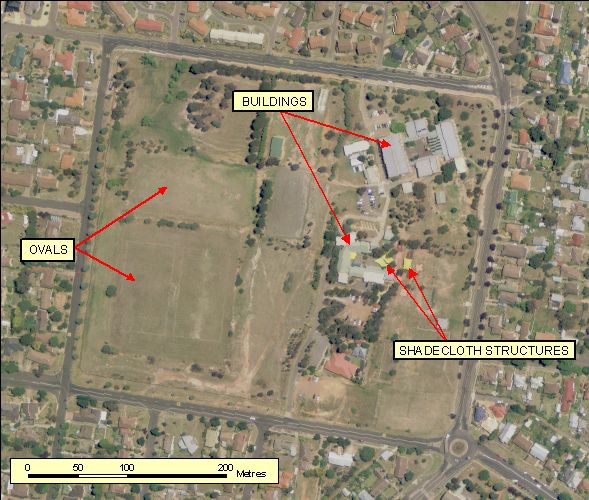
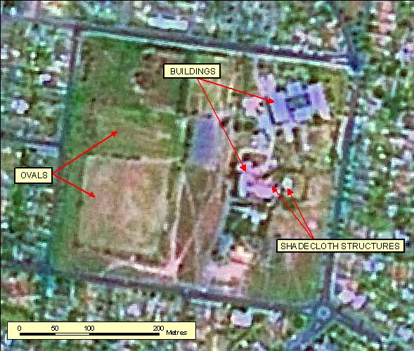
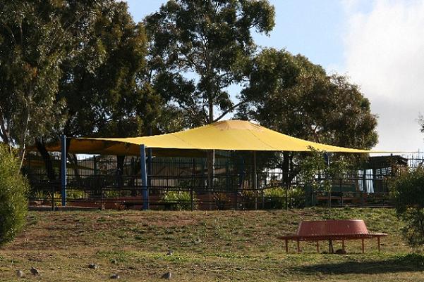
- Schools throughout Australia are building shadecloth structures to protect students from Solar UV radiation while taking outside breaks from their studies. These are not buildings but often exist over paved or other artifical surface. Shade cloth structures can be distinguished by the shape which is generally triangle or rectangular with curved edges due to draping.
|
| Regional Considerations: |
- School complexes within urban and regional centres generally use a large land area which is reflective of the number of students eg 200 plus. Whereas schools in remote rural townships may only have 15 students and this will be reflected in the extent of land utilised by the school.
|
| Figure: 2.1.3.4 Representation of a School in association with surrounding features. |
[back to top]
2.1.3.5 Example 5
| |
| Location of Example: |
149°42'38" East, 34°44'38" South |
| Distinctive Characteristics: |
- School complexes within Built Up Areas are normally associated with playing fields. This combination of grouped Buildings and sporting fields distinguishes them from other complexes.
- School Buildings may be built over various eras making them distinguishable from surrounding Builtup only by size and proximity to playing fields as per example 1. Otherwise, all buildings can be built at the same time either as a distinct set of buildings or as inter connected buildings as per examples 2 and 4 respectively.
- Schools throughout Australia are building shadecloth structures to protect students from Solar UV radiation while taking outside breaks from their studies. These are not buildings but often exist over paved or other artifical surface. Shade cloth structures can be distinguished by the shape which is generally triangle or rectangular with curved edges due to draping.
|
| Regional Considerations: |
- School complexes within urban and regional centres generally use a large land area which is reflective of the number of students eg 200 plus. Whereas schools in remote rural townships may only have 15 students and this will be reflected in the extent of land utilised by the school.
|
| Figure: 2.1.3.5 Representation of a School with Shade Cloth structures. |
[back to top]
2.1.4 Hospitals
2.1.4.1 Example 1
| |
| Location of Example: |
152°49'33" East, 25°17'54" South |
| Distinctive Characteristics: |
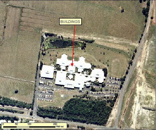
- Hospitals normally have interlinking Buildings, large carparks and may have an associated Helipad on either the grounds or on the roof.
- Normally these are well defined in Reference Material.
|
| Regional Considerations: |
|
| Figure: 2.1.4.1 Representation of a Hospital in association with surrounding features. |
[back to top]
2.1.5 Golf Courses
2.1.5.1 Example 1
| |
| Location of Example: |
152°49'16" East, 25°16'45" South |
| Distinctive Characteristics: |
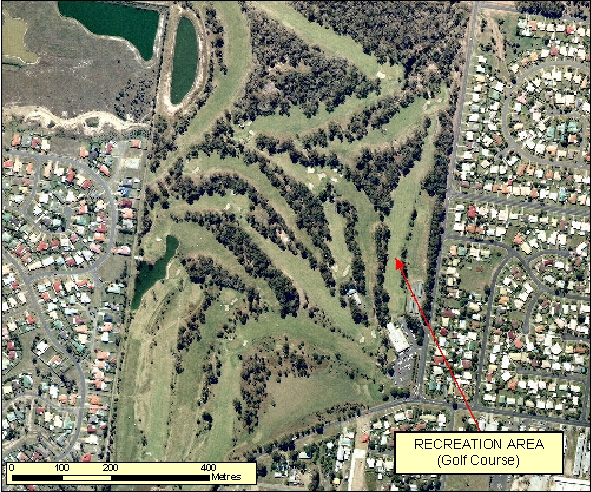
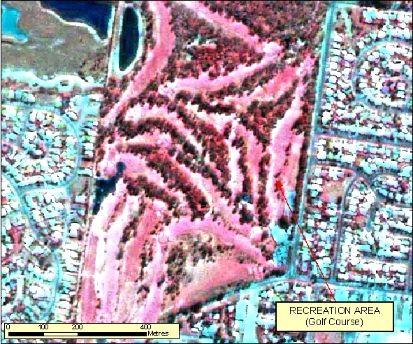
- Golf courses have very characteristic fairways that are close together and generally lined with trees.
- There are often water bodies associated with the course and numerous small sand traps mostly at the ends of the fairways.
- Golf Courses often have a definite boundary and are within or adjacent to residential areas.
- In Figure: 2.1.5.1b note the light red signature of the grass fairways and the dark red signature of the aligning trees. Also note the contrast of the surrounding residential area represented as bright blue. The sand traps show up as white and the water bodies shows up as a deep blue.
|
| Regional Considerations: |
|
| Figure: 2.1.5.1 Representation of a Golf Course. |
[back to top]
2.1.5.2 Example 2
| |
| Location of Example: |
149°06'35" East, 35°19'55" South |
| Distinctive Characteristics: |
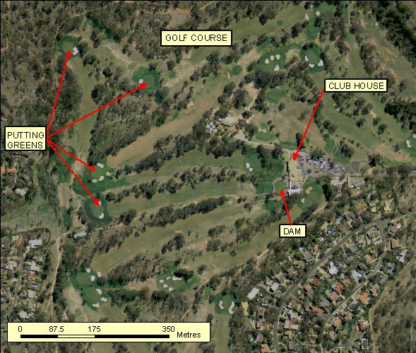
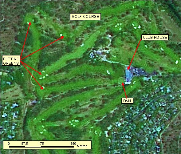
- Golf courses have very characteristic fairways that are close together and generally lined with trees.
- There are often water bodies associated with the course and numerous small sand traps mostly at the ends of the fairways.
- Golf Courses often have a definite boundary and are within or adjacent to residential areas.
- In Figure: 2.1.5.2a note the stronger green of the putting green at the end of the fairways. When water etc is limited, putting greens are given higher maintence then the fairways, providing the distinction seen in this image. A centralised clubhouse with parking to one side the golf course is also to be expected for the meeting of golfers prior to and after the their play.
|
| Regional Considerations: |
|
| Figure: 2.1.5.2 Representation of a Golf Course. |
[back to top]
2.1.6 Greenhouses
2.1.6.1 Example 1
| |
| Location of Example: |
152°25'53" East, 24°57'25" South |
| Distinctive Characteristics: |
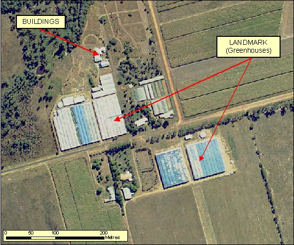
- Greenhouses are generally located near farm infrastructure and Homesteads.
- Greenhouses tend to have uniquely reflective surfaces, and often appear as a raised square or rectangular structures, evident by their shadow.
- They are distinguishable by their segmented, grid like roof pattern.
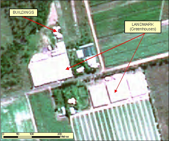
- In Figure: 2.1.6.1b the segmentations of the rooves of the greenhouses are not clear and therefore can easily be confused with large sheds or Buildings.
|
| Regional Considerations: |
|
| Figure: 2.1.6.1 Representation of Greenhouses in association with surrounding features. |
[back to top]
2.1.6.2 Example 2
| |
| Location of Example: |
152°15'10" East, 24°44'5" South |
| Distinctive Characteristics: |
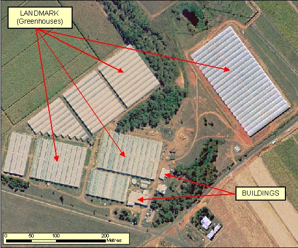
- Greenhouses are generally located near farm infrastructure and Homesteads.
- Greenhouses tend to have uniquely reflective surfaces, and often appear as a raised square or rectangular structures, evident by their shadow.
- They are distinguishable by their segmented, grid like roof pattern.
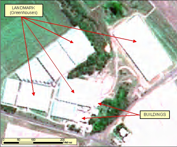
- In Figure: 2.1.6.2b the segmentations of the rooves of the greenhouses are not clear and therefore can easily be confused with large sheds or Buildings.
|
| Regional Considerations: |
|
| Figure: 2.1.6.2 Representation of Greenhouses in association with surrounding features. |
[back to top]
2.1.6.3 Example 3
| |
| Location of Example: |
149°05'20" East, 35°17'47" South |
| Distinctive Characteristics: |
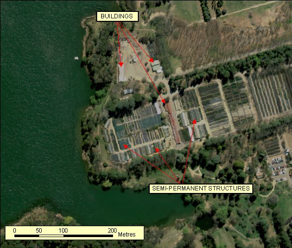
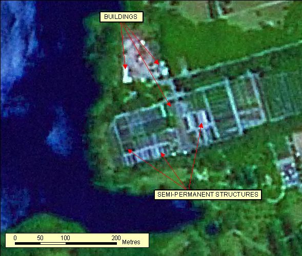
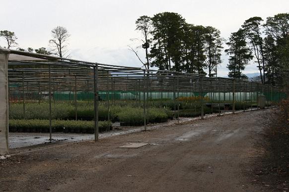
- Commerical plant industries may have a series of shadecloth semi permanent structures used to grow and protect mature plants.
- These shadecloth semi permanent structures tend to be uniform in size, shape and colour. Their layout is organised and tightly bunched. The structures framework on high resolution imagery may be visible through the transparent roofing.
- Due to there semi permanent nature they are not considered Buildings but may be applicable as landmark areas (Agricultural Production) dependant on scale of capture.
|
| Regional Considerations: |
|
| Figure: 2.1.6.3 Representation of semi permanent shade cloth structures for plant growth and protection. |
[back to top]
2.1.7 Rifle Ranges
2.1.7.1 Example 1
| |
| Location of Example: |
152°41'00" East, 25°30'38" South |
| Distinctive Characteristics: |
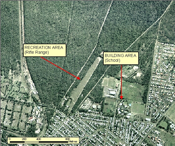
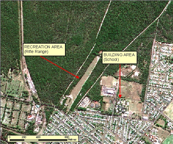
- In Figure: 2.1.7.1 the rectangular cleared strip indicates a Rifle Range. The markers are contained along the length of the range to indicate the distance for the shoot. There is also generally a club house associated with the Rifle Range
|
| Regional Considerations: |
|
| Figure: 2.1.7.1 Representation of a Rifle Range in association with surrounding features. |
[back to top]
2.1.7.2 Example 2
| |
| Location of Example: |
149°11'55" East, 35°12'48" South |
| Distinctive Characteristics: |
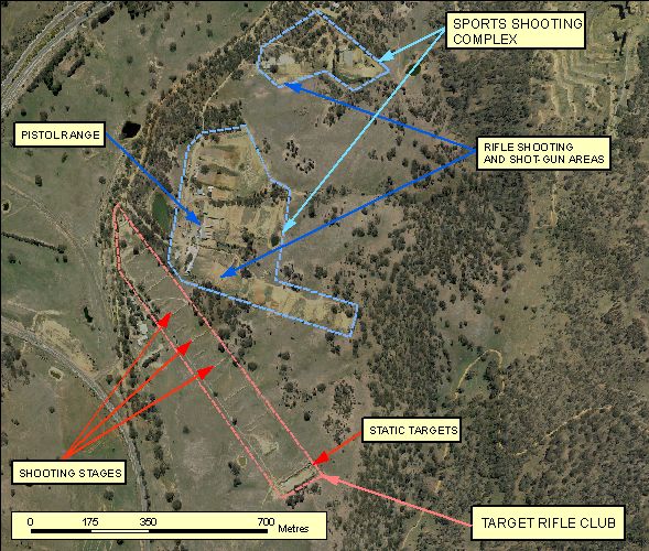
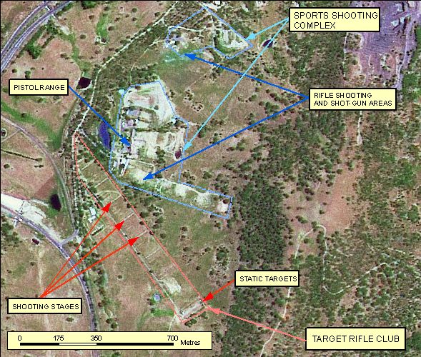
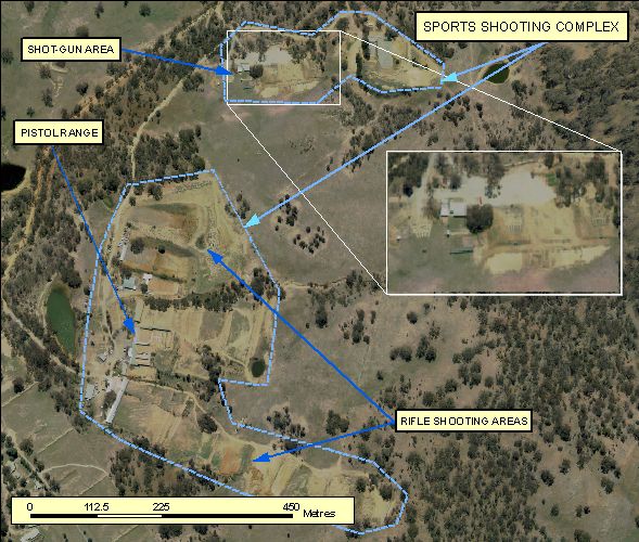
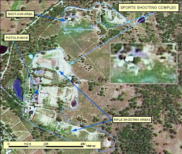
- Example 2.1.7.2 Shows a Shooting Complex. A shooting complex made up of different types of gun shooting accuracy disciplines is designated as a Miscellaneous Area feature type. Rifle ranges which have a specific elongated rectangular shape for rifle shooting should be captured separately as a Rifle Range feature type when it meets the data capture or inclusion size criteria as appropriate otherwise where applicable it should be merged in with the associated gun complex's miscellaneous area.
- Figures 2.1.7.2c and 2.1.7.2d shows orthophotography and spot enlargements over the sporting complex (excluding the rifle range) for clearer delineation of features.
- Shooting ranges are usually isolated from built up areas. There is also generally a club house or club houses associated with the shooting areas.
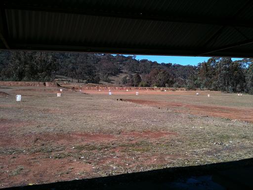
- A rifle range is characterised by regularly set out 'stages' 100m apart, where shooters position themselves to shoot towards a static target at the other end of the range.
- A Sports Shooting Complex is divided up into different areas dependent on the shooting type.
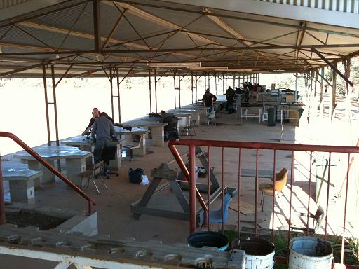
- Pistol shooting areas are characterised by an enclosed perimeter structure and a covered staging area where the shooters stand.
- Other areas such as those for rifle shooting may also have a covered staging areas where shooters stand with the targets positioned at the designated positions away from the staging area as indicated by the regularly spaced deliniations. These areas also have a perimeter consisting of a raised vegetation bank to prevent stray shots escaping the designated enclosure.
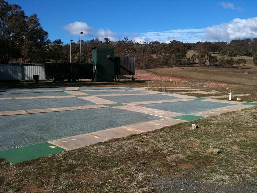
- The section for shot-gun usage usually have associated infrustructure such as distinctive (uncovered) staging platforms in a fan configuration.
|
| Regional Considerations: |
|
| Figure: 2.1.7.2 Representation of a Shooting Complex. |
[back to top]
2.1.8 Race Courses
2.1.8.1 Example 1
| |
| Location of Example: |
151°54'58" East, 27°55'30" South |
| Distinctive Characteristics: |
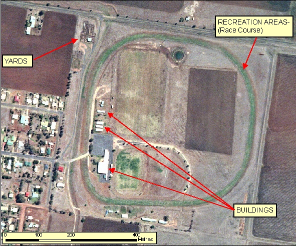
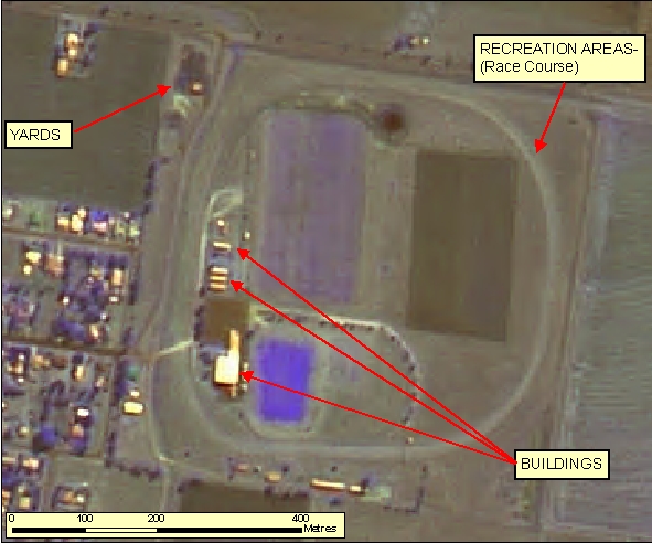
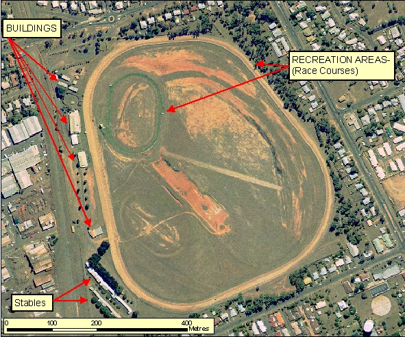
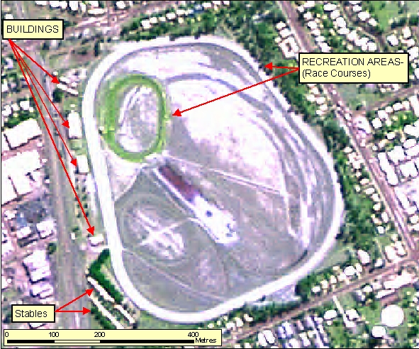
- Race Courses generally have a distinctive circular signature as well as associated infrastructure; Buildings and Yards.
- Race Courses normally have an associated smaller internal or adjacent track for horse training purposes.
- The Orthophotography shows how the Race Course track has been irrigated causing a contrast in relation to the surrounding dry ground.
|
| Regional Considerations: |
- Race Courses are typically found on the outer edge of Built Up Areas.
|
| Figure: 2.1.8.1 Representation of a Race Course in association with surrounding features. |
[back to top]
2.1.8.2 Example 2
| |
| Location of Example: |
149°08'27" East, 35°13'57" South |
| Distinctive Characteristics: |
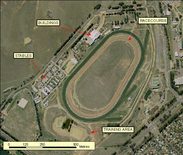
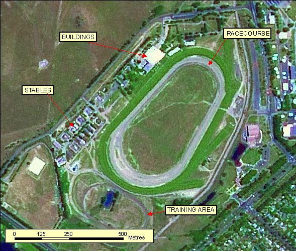
- Race Courses generally have a distinctive circular signature as well as associated infrastructure; Buildings and Yards.
- Race Courses normally have an associated smaller internal or adjacent track for horse training purposes.
- This example shows two tracks within the Race Course facility with two different surfaces turf and dirt/sand.
|
| Regional Considerations: |
- Race Courses are typically found on the outer edge of Built Up Areas.
|
| Figure: 2.1.8.2 Representation of a Race Course in association with surrounding features. |
[back to top]
2.1.8.3 Example 3
| |
| Location of Example: |
152°21'17" East, 24°53'23" South |
| Distinctive Characteristics: |
- Race Courses generally have a distinctive circular signature as well as associated infrastructure; Buildings and Yards.
- Race Courses normally have an associated smaller internal or adjacent track for horse training purposes.
- The Orthophotography shows how the Race Course track has been irrigated causing a contrast in relation to the surrounding dry ground.
|
| Regional Considerations: |
- Race Courses are typically found on the outer edge of Built Up Areas.
|
| Figure: 2.1.8.3 Representation of a Race Course in association with surrounding features. |
[back to top]
2.1.9 Cemeteries
2.1.9.1 Example 1
| |
| Location of Example: |
152°40'22" East, 25°30'52" South |
| Distinctive Characteristics: |
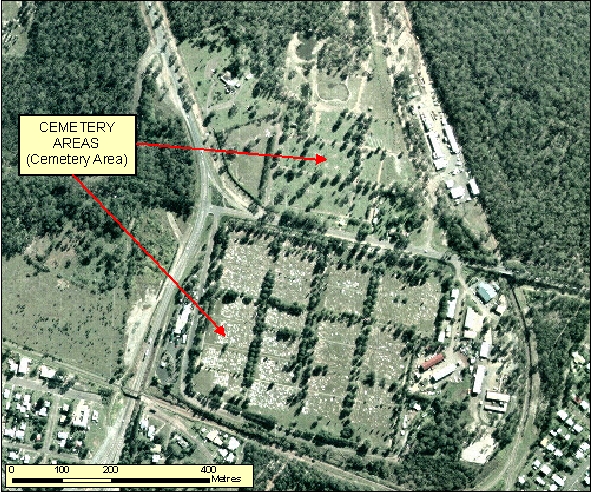
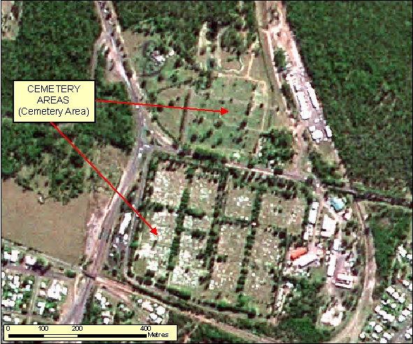
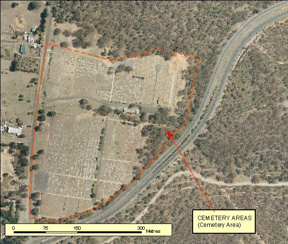
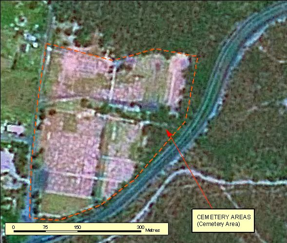
- Medium to large sized cemeteries are often within or on the outskirts of Population Centres.
- In Figure: 2.1.9.1 the white headstones are clearly visible in the southern part of the Cemetery.
|
| Regional Considerations: |
|
| Figure: 2.1.9.1 Representation of a Cemetery in association with surrounding features. |
[back to top]
2.1.9.2 Example 2
| |
| Location of Example: |
149°45'15" East, 34°44'41" South |
| Distinctive Characteristics: |
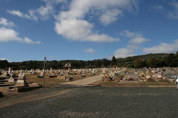
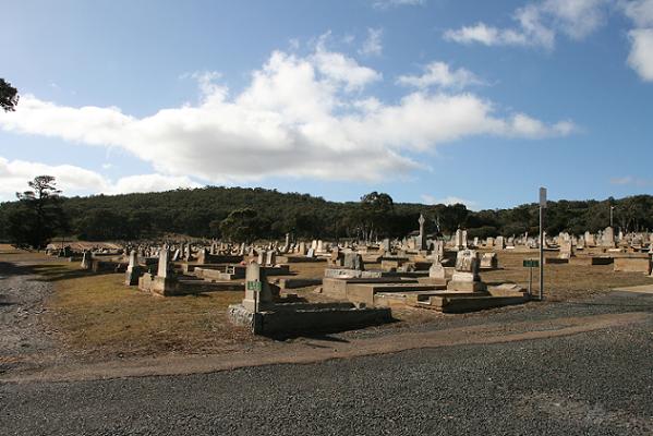
- Medium to large sized cemeteries are often within or on the outskirts of Population Centres.
- In Figure: 2.1.9.2 the white headstones are clearly visible in rows and tightly spaced.
|
| Regional Considerations: |
|
| Figure: 2.1.9.2 Representation of a Cemetery in association with surrounding features. |
[back to top]
2.1.10 Substations
2.1.10.1 Example 1
| |
| Location of Example: |
152°22'09" East, 24°54'29" South |
| Distinctive Characteristics: |
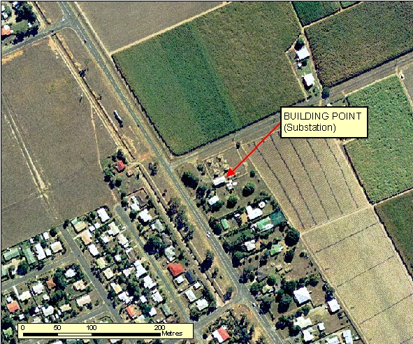
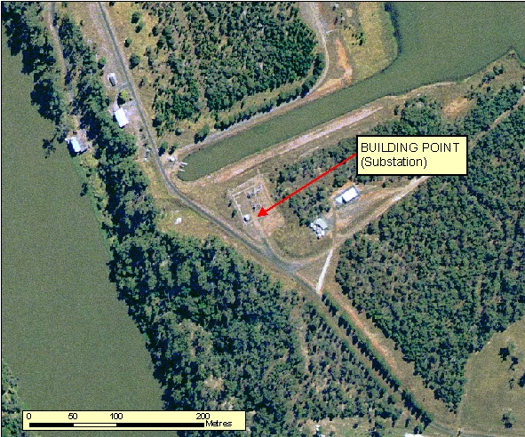
- As shown in Figure: 2.1.10.1a the complex depicting the Substation layout can be normally seen on ortho-photography, however only capture the Building associated with this feature.
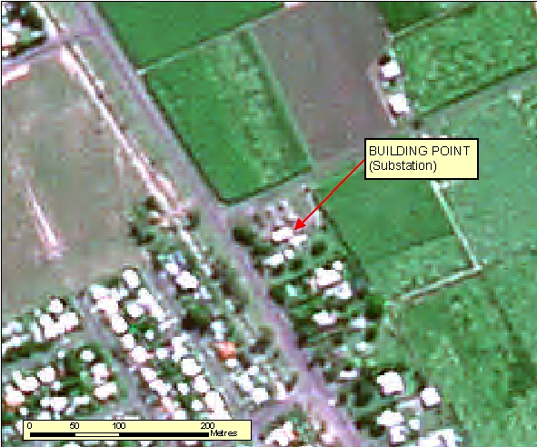
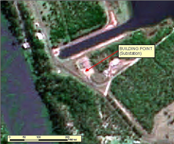
- As shown in Figure: 2.1.10.1b Substations are difficult to interpret from Spot imagery and would probably need to be supplemented with revision material to proper identify this feature. The Building is visible, but cannot be interpreted alone.
- Substations generally are a central hub of connectivity for a Powerline network.
- A Fence line boundary is normally visible to exclude public access.
|
| Regional Considerations: |
|
| Figure: 2.1.10.1 Representation of a Substation in association with surrounding features. |
[back to top]
2.1.10.2 Example 2
| |
| Location of Example: |
152°11'11" East, 24°55'51" South |
| Distinctive Characteristics: |
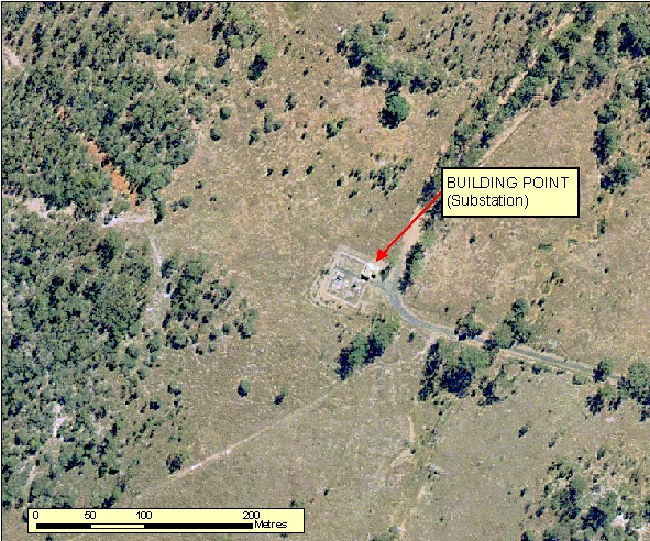
- As shown in Figure: 2.1.10.2a the complex depicting the Substation layout can be normally seen on ortho-photography, however only capture the Building associated with this feature.
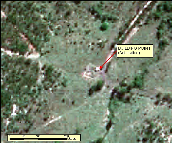
- As shown in Figure: 2.1.10.2b Substations are difficult to interpret from Spot imagery and would probably need to be supplemented with revision material to proper identify this feature. The Building is visible, but cannot be interpreted alone.
- Substations generally are a central hub of connectivity for a Powerline network.
- A Fence line boundary is normally visible to exclude public access.
|
| Regional Considerations: |
|
| Figure: 2.1.10.2 Representation of a Substation in association with surrounding features. |
[back to top]
2.1.10.3 Example 3
| |
| Location of Example: |
152°15'25" East, 24°55'51" South |
| Distinctive Characteristics: |
- As shown in Figure: 2.1.10.3a the complex depicting the Substation layout can be normally seen on ortho-photography, however only capture the Building associated with this feature.
- As shown in Figure: 2.1.10.3b Substations are difficult to interpret from Spot imagery and would probably need to be supplemented with revision material to proper identify this feature. The Building is visible, but cannot be interpreted alone.
- Substations generally are a central hub of connectivity for a Powerline network.
- A Fence line boundary is normally visible to exclude public access.
|
| Regional Considerations: |
|
| Figure: 2.1.10.3 Representation of a Substation in association with surrounding features. |
[back to top]
2.1.11 Built Up Area Delineation
2.1.11.1 Example 1
| |
| Location of Example: |
153°01'13" East, 27°41'44" South |
| Distinctive Characteristics: |
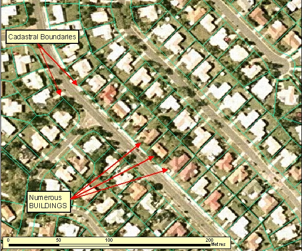
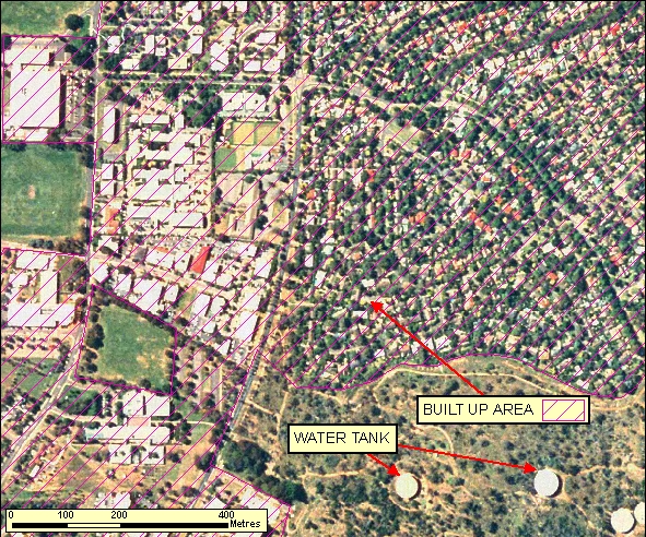
- Figure: 2.1.11.1 is an example of part of a Built Up Area in densely populated new suburbs of a capital city.
- A Built Up Area will be representative of all buildings which are set out on street patterns.
- The boundaries of a Built Up Area should be defined with consideration to the surrounding landscape and location in Australia (e.g. middle of the Northern Territory versus older suburbs in a capital city versus newer suburbs in a fast growing satellite town).
- In General, Built Up Areas should consist of the majority of land parcels being less than 3600 square metres and man-made structures (e.g pools, homes, garages, etc) should occupy greater than approximately 15 percent of the land parcel.
|
| Regional Considerations: |
|
| Figure: 2.1.11.1 Representation of a Built Up Area. |
[back to top]
2.1.11.2 Example 2
| |
| Location of Example: |
153°01'12" East, 27°41'51" South |
| Distinctive Characteristics: |
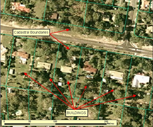
- Figure: 2.1.11.2 is an example of the peri-urban zone outside a Built Up Area. This should not be captured as a Built Up Area.
- A Built Up Area will be representative of all buildings which are set out on street patterns.
- The boundaries of a Built Up Area should be defined with consideration to the surrounding landscape and location in Australia (e.g. middle of the Northern Territory versus older suburbs in a capital city versus newer suburbs in a fast growing satellite town).
- In General, Built Up Areas should consist of the majority of land parcels being less than 3600 square metres and man-made structures (e.g pools, homes, garages, etc) should occupy greater than approximately 15 percent of the land parcel.
|
| Regional Considerations: |
|
| Figure: 2.1.10.2 Representation of a peri-urban zone outside of a Built Up Area |
[back to top]
2.1.11.3 Example 3
| |
| Location of Example: |
153°01'12" East, 27°41'51" South |
| Distinctive Characteristics: |
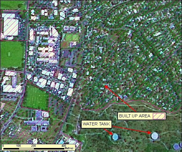
- A Built Up Area will be representative of all buildings which are set out on street patterns.
- The boundaries of a Built Up Area should be defined with consideration to the surrounding landscape and location in Australia (e.g. middle of the Northern Territory versus older suburbs in a capital city versus newer suburbs in a fast growing satellite town).
- In General, Built Up Areas should consist of the majority of land parcels being less than 3600 square metres and man-made structures (e.g pools, homes, garages, etc) should occupy greater than approximately 15 percent of the land parcel.
|
| Regional Considerations: |
|
| Figure: 2.1.11.3 Representation of a Built Up Area |
[back to top]
2.1.11.4 Example 4
| |
| Location of Example: |
149°05'55" East, 35°19'18" South |
| Distinctive Characteristics: |
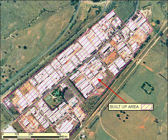
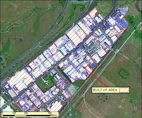
- A Built Up Area will be representative of all buildings which are set out on street patterns.
- The boundaries of a Built Up Area should be defined with consideration to the surrounding landscape and location in Australia (e.g. middle of the Northern Territory versus older suburbs in a capital city versus newer suburbs in a fast growing satellite town).
- In General, Built Up Areas should consist of the majority of land parcels being less than 3600 square metres and man-made structures (e.g pools, homes, garages, etc) should occupy greater than approximately 15 percent of the land parcel.
|
| Regional Considerations: |
|
| Figure: 2.1.11.4 Representation of a Built Up Area |
[back to top]
2.1.12 Miscellaneous Areas
2.1.12.1 Example 1
| |
| Location of Example: |
152°19'24" East, 24°53'36" South |
| Distinctive Characteristics: |
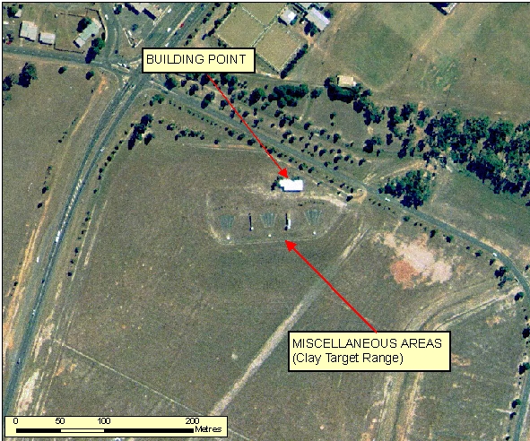
- Figure: 2.1.12.1 shows a Clay Target Range. This can be distinguished by the regular lines terminating at a fixed target.
|
| Regional Considerations: |
|
| Figure: 2.1.12.1 Representation of a Clay Target Range in association with surrounding features. |
[back to top]
2.1.12.2 Example 2
| |
| Location of Example: |
149°11'55" East, 35°12'48" South |
| Distinctive Characteristics: |
- Example 2.1.12.2 Shows a Shooting Complex. A shooting complex made up of different types of gun shooting accuracy disciplines is designated as a Miscellaneous Area feature type. Rifle ranges which have a specific elongated rectangular shape for rifle shooting should be captured separately as a Rifle Range feature type when it meets the data capture or inclusion size criteria as appropriate otherwise where applicable it should be merged in with the associated gun complex's miscellaneous area.
- Figures 2.1.12.2c and 2.1.12.2d shows orthophotography and spot enlargements over the sporting complex (excluding the rifle range) for clearer delineation of features.
- Shooting ranges are usually isolated from built up areas. There is also generally a club house or club houses associated with the shooting areas.
- A rifle range is characterised by regularly set out 'stages' 100m apart, where shooters position themselves to shoot towards a static target at the other end of the range.
- A Sports Shooting Complex is divided up into different areas dependent on the shooting type.
- Pistol shooting areas are characterised by an enclosed perimeter structure and a covered staging area where the shooters stand.
- Other areas such as those for rifle shooting may also have a covered staging areas where shooters stand with the targets positioned at the designated positions away from the staging area as indicated by the regularly spaced deliniations. These areas also have a perimeter consisting of a raised vegetation bank to prevent stray shots escaping the designated enclosure.
- The section for shot-gun usage usually have associated infrustructure such as distinctive (uncovered) staging platforms in a fan configuration.
|
| Regional Considerations: |
|
| Figure: 2.1.12.2 Representation of a Shooting Complex. |


[back to top]
2.1.13 Place of Worship
2.1.13.1 Example 1
| |
| Location of Example: |
149°42'55" East, 34°45'16" South |
| Distinctive Characteristics: |
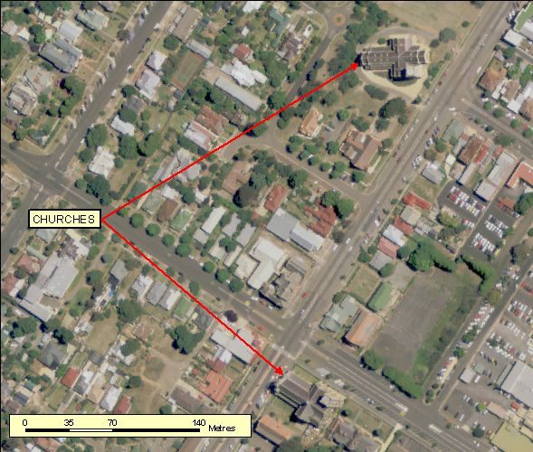
- Distinctive Characteristics is highly dependant on the religion or practices being worshiped. Each example has tried to denote buildings used within different forms of worship, please refer to all examples to not restrict the interpretation of places of worship. Additional examples will be added over time as good examples are found on imagery.
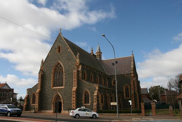
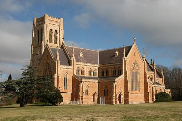
- Example 1: Denotes churchs used within the Christian faith.
- A Church buildings primary purpose is to facilitate the meeting of Christian denominations.
- Church buildings are often built in the shape of a cross and can be seen as relatively large 't'-shaped tall buildings they are also often topped with a bell tower or dome.
|
| Regional Considerations: |
|
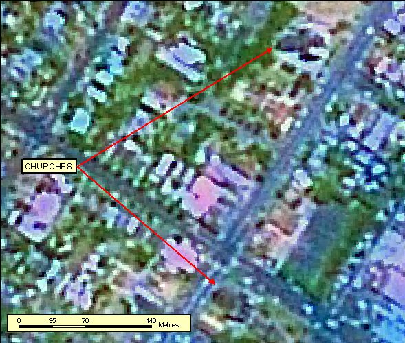
| Figure: 2.1.13.1 Representation of a Christian Church. |
[back to top]
2.1.13.2 Example 2
| |
| Location of Example: |
153°04'32" East, 27°31'37" South |
| Distinctive Characteristics: |
- Distinctive Characteristics is highly dependant on the religion or practices being worshiped. Each example has tried to denote buildings used within different forms of worship, please refer to all examples to not restrict the interpretation of places of worship. Additional examples will be added over time as good examples are found on imagery.
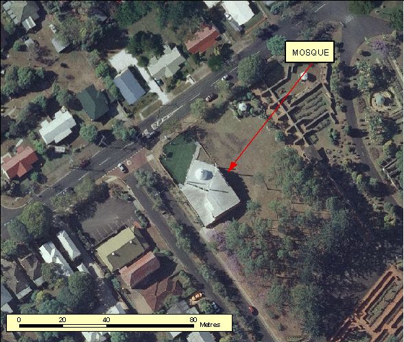
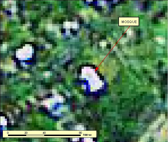
- Example 2: Denotes a Mosque used within the Islamic faith.
- A Mosque buildings is to facilitate the meeting of Islamic denominations. They are used for prayer, information, education and dispute settlement.
- Mosques are often built with a minaret, dome and prayer hall.
|
| Regional Considerations: |
|
| Figure: 2.1.13.2 Representation of a Islamic Mosque. |
[back to top]
2.1.13.3 Example 3
| |
| Location of Example: |
149°06'43" East, 35°18'16" South |
| Distinctive Characteristics: |
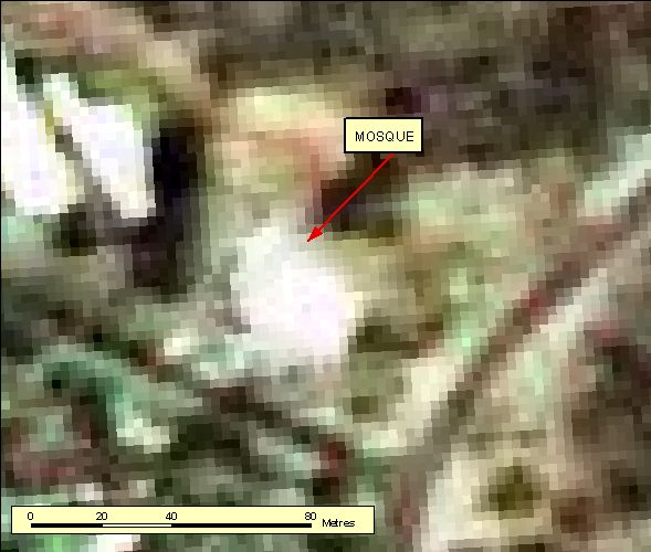
- Distinctive Characteristics is highly dependant on the religion or practices being worshiped. Each example has tried to denote buildings used within different forms of worship, please refer to all examples to not restrict the interpretation of places of worship. Additional examples will be added over time as good examples are found on imagery.
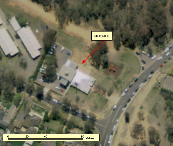
- Example 3: Denotes a Mosque used within the Islamic faith.
- A Mosque buildings is to facilitate the meeting of Islamic denominations. They are used for prayer, information, education and dispute settlement.
- Mosques are often built with a minaret, dome and prayer hall.
|
| Regional Considerations: |
|
| Figure: 2.1.13.3 Representation of a Islamic Mosque. |
[back to top]
2.1.13.4 Example 4
| |
| Location of Example: |
150°50'55" East, 34°27'58" South |
| Distinctive Characteristics: |
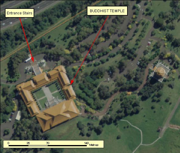
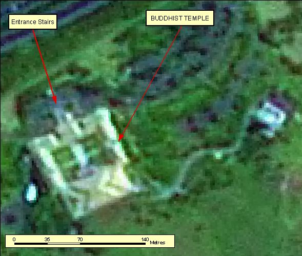
- Distinctive Characteristics is highly dependant on the religion or practices being worshiped. Each example has tried to denote buildings used within different forms of worship, please refer to all examples to not restrict the interpretation of places of worship. Additional examples will be added over time as good examples are found on imagery.
- Example 1: Denotes temples used within the Buddhist faith.
- A temples buildings primary purpose is to facilitate the prayer of Buddhist denominations.
- Buddhist temples generally have a building with a central square courtyard. The have distinctive steps leading to the main structure and entry statues. Many Buddhist temples have formal landscaped gardens.
|
| Regional Considerations: |
|
| Figure: 2.1.13.4 Representation of a Buddhist Temple. |
[back to top]
2.1.14 Ovals
2.1.14.1 Example 1
| |
| Location of Example: |
149°08'04" East, 35°19'05" South |
| Distinctive Characteristics: |
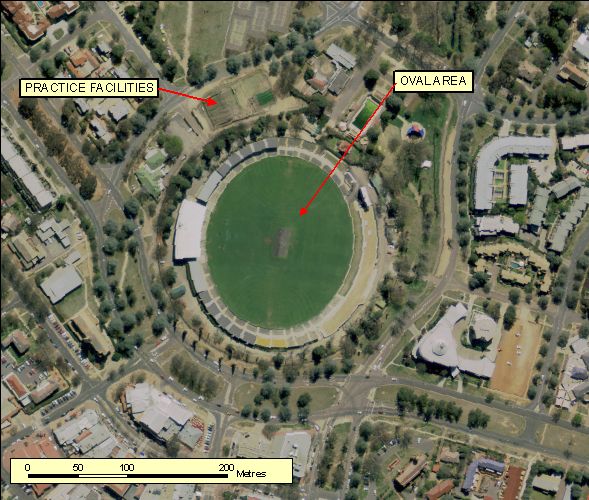
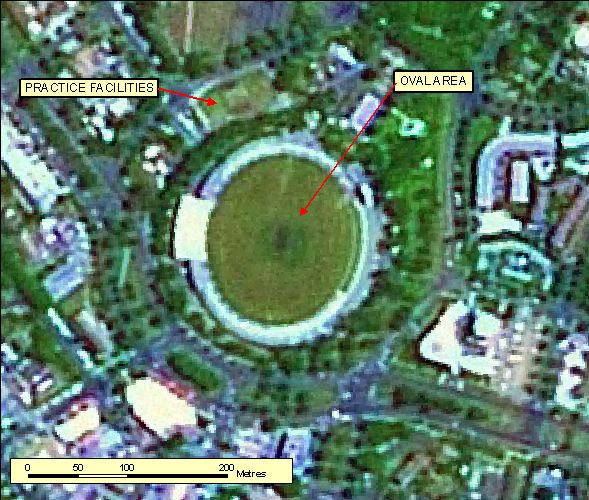
- An Oval Area is an open area of land with a regular elliptical shape developed as a sporting ground for the playing of football, athletics, cricket and the like.
- Line markings and/or a cricket pitch is often visible in imagery.
- Associated infrastructure can include a grandstand, club buildings, lighting/goal post structures, adjacent practice or other sport facilities (tennis or netball courts)
|
| Regional Considerations: |
- Generally occur within or near populated centres.
|
| Figure: 2.1.14.2 Representation of a Oval. |
[back to top]
2.1.14.2 Example 2
| |
| Location of Example: |
148°54'27" East, 34°50'08" South |
| Distinctive Characteristics: |
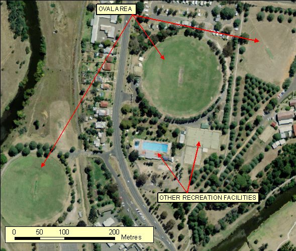
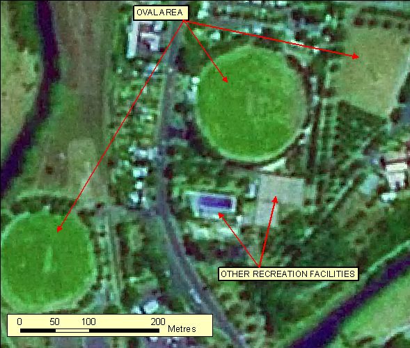
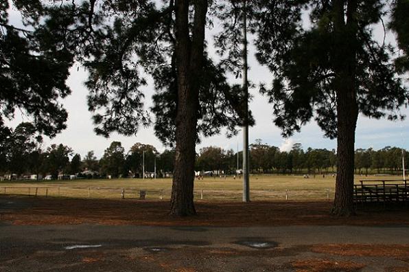
- An Oval Area is an open area of land with a regular elliptical shape developed as a sporting ground for the playing of football, athletics, cricket and the like.
- Line markings and/or a cricket pitch is often visible in imagery.
- Associated infrastructure can include a grandstand, club buildings, lighting/goal post structures, adjacent practice or other sport facilities (tennis or netball courts)
|
| Regional Considerations: |
- Generally occur within or near populated centres.
|
| Figure: 2.1.14.2 Representation of a Oval. |
[back to top]
2.1.15 Waste Management Areas
2.1.15.1 Example 1
| |
| Location of Example: |
149°45'19" East, 34°45'08" South |
| Distinctive Characteristics: |
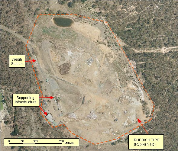
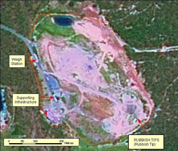
- Example 1 is a Rubbish Tip
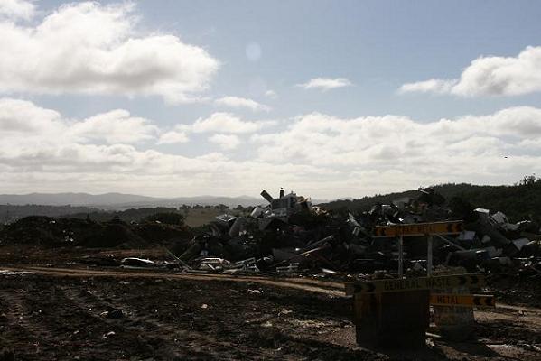
- Simple rubbish tips have areas of cleared land, piles of rubbish and an entry gate or building for the control of the passage, and type, of refuse allowed into the tip.
- A larger rubbish tip may be more sophisticated and include such entities as additional support buildings, weigh bridges, compositing heaps (where green waste is converted into commerical fertilizer), other recycling facilities and methane extraction power generators.
|
| Regional Considerations: |
- Generally occur within or near populated centres.
|
| Figure: 2.1.15.1 Representation of a Rubbish Tip. |
Topic contact: mapfeedback@ga.gov.au Last updated: January 20, 2012


