2.2.2 Roads Vs Linear Features
2.2.2.9 Example 9
| |
| Location of Example: |
133°49'28" East, 23°51'36" South |
| Distinctive Characteristics: |
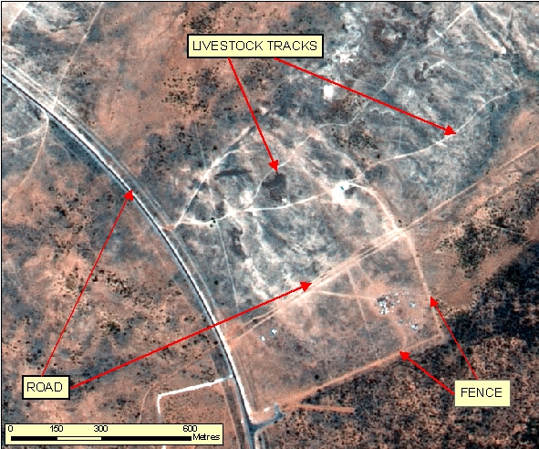
- Figure 2.2.2.9 is an example multiple fences and a livestock track.
- Livestock tracks generally comprise of multiple tracks converging onto one point or area, such as; Dams, streams/river banks, vehicle access point (often a paddock corner or convergence of two or more fence lines), or a feeding point (eg silo).
- Livestock tracks can be seasonal.
- Livestock tracks may not be visible on imagery after strong vegetative growth following a rainy season.
- Livestock tracks may also be winding, may run parallel to a watercourse for some distance, and may appear to disappear under foliage and reappear some distance way.
- Vehicle Tracks, in the vicinity of livestock tracks, will be singular, will often terminate at a watering or feeding point, are not seasonal and are generally better defined on imagery than livestock tracks.
- Fences are usually rectilinear and are generally better defined on imagery than livestock tracks. Fences cam however converge at a point where livestock tracks terminate.
- Reference and Supporting Material may assist in differentiating between Vehicular Tracks, Fences and livestock tracks.
|
| Regional Considerations: |
|
| Figure: 2.2.2.9 Representation of Livestock Tracks in association surrounding features. |

Topic contact: mapfeedback@ga.gov.au Last updated: January 20, 2012

