


Building Australia's capacity to estimate the impact of terrorist blasts
31 October 2016

Building upon its existing natural hazard modelling expertise, Geoscience Australia has developed a capability which helps estimate the potential impact of terrorist blasts across a number of Australian central business districts (CBDs).
A summary of the structure of the
ARPC scheme
This blast modelling capability assists the Australian Reinsurance Pool Corporation (ARPC) to better understand the potential financial exposure to a range of blast scenarios. With this information, the Australian Government is now able to more reliably estimate insured loss in the event of a terrorist incident.
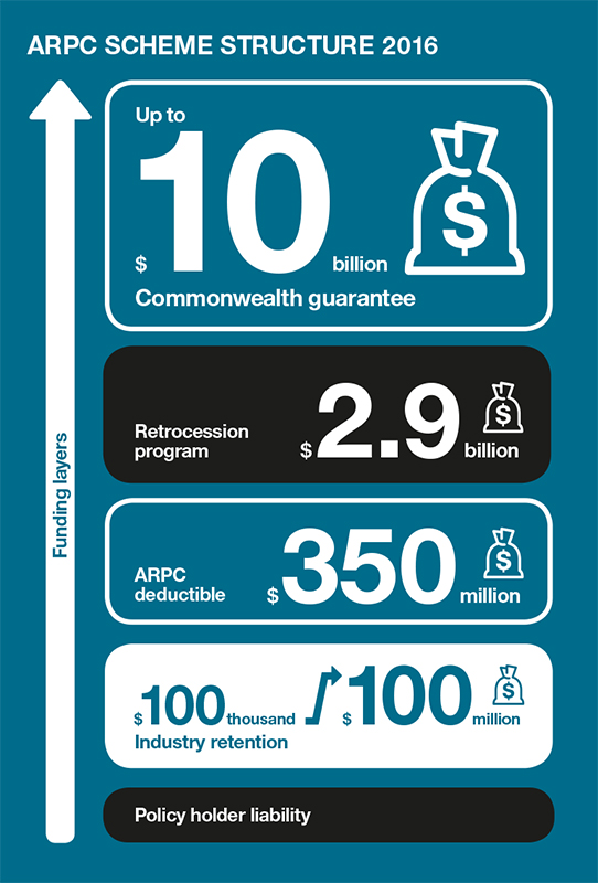
The ARPC is a Commonwealth corporate entity established under the Terrorism Insurance Act 2003, in response to the terrorist attacks in the United States in September 2001. Those attacks triggered a global withdrawal of terrorism insurance cover that resulted in an insurance market failure. It was established to provide reinsurance cover for eligible terrorism losses, and now manages an insurance pool of approximately $13.4 billion to meet any claims that may arise.
Geoscience Australia's capability enables modelling of a range of scenarios to better understand the exposed risk and if the financial capacity of the government's insurance pool can meet it.
Blast loss estimates can now be provided to the ARPC in a single business day for the Sydney, Melbourne, Adelaide and Brisbane CBDs. Should a terrorist incident occur, loss estimates can then be continually updated to incorporate intelligence from the field as it is received. Furthermore, the capability can simulate many blast locations across CBDs and provides the ability to estimate expected total losses. The capability is still in development for the Perth CBD, and is expected to be operational by the end of 2016.
Building upon existing natural hazard modelling capability
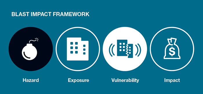
The blast loss modelling framework adopted by Geoscience Australia for this work considers four key components: hazard, exposure, vulnerability and impact. This is consistent with natural hazard impact modelling used by the insurance industry and a range of other sectors which include emergency management.
Estimated insured loss is determined based on potential impact to buildings, contents and business interruption. Blast damage costs are calculated using building reconstruction costs and the level of damage sustained by components such as doors, windows and walls. It also takes into account the building size, usage, location and quality.
Geoscience Australia's blast loss modelling framework
All buildings included in a particular scenario are assessed for damage and any necessary repairs costed. Insured loss estimates can then be estimated building-by-building for the three insurance covers: building, contents and business interruption.
In addition to providing estimates of loss following a declared terrorist incident, the capability can also be used to assess losses at locations across entire CBDs. This can identify 'hot spots' and can also inform the ARPC on likely losses by city, and the suitability of the scheme to cover these events. Melbourne and Sydney have each been assessed using more than 500 analyses per city.
Geoscience Australia is currently exploring options to enhance and adapt the capability. This includes adding features such as human activity and casualty models, and urban search and rescue metrics such as predictions of people trapped during partial or complete building collapse. This will expand its usefulness as an emergency management and counter-terrorism planning tool.
Further information:
- Snapshot video: Development of a terrorism loss estimation capability for the Australian Government [01:06]