News Geoscience Australia’s role in space weather monitoring
Last updated:7 June 2023
Andrew Lewis—Geomagnetism Lead Scientist, shares his insights on the potential threat of space weather, and how Geoscience Australia’s network of geomagnetic observatories play their part protecting communities and infrastructure.
Imagine if all the electrical grids and devices in the world suddenly stopped working; or all the satellites currently in orbit dropped out, resulting in no satellite communications, and no GPS.
In our modern world this would be catastrophic. Economies would take a devastating hit, human lives could be put into danger, and whole infrastructures could suffer.
Space weather, also known as electromagnetic storm activity, has the potential to cause such impacts.
This is one of the reasons why Geoscience Australia maintains a network of geomagnetic observatories. Our observatories form part of a global network and contribute to Australian space weather monitoring services. This monitoring allows potential hazards caused by magnetic storms to be mitigated, protecting communities by minimising the impact to Australian infrastructure such as electrical grids.
So, what exactly is electromagnetic storm activity, and why can it wreak so much havoc?
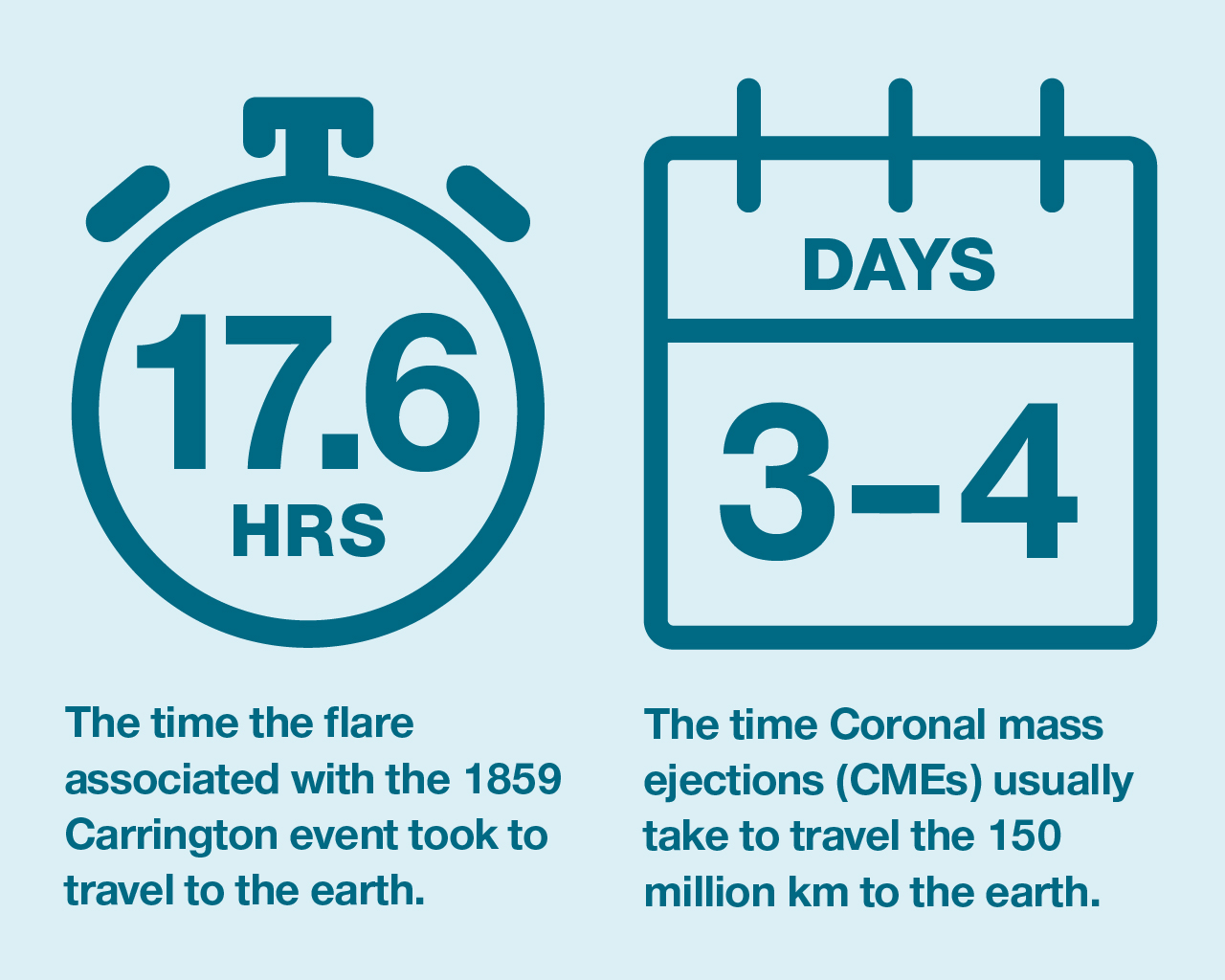
Geomagnetic storms result from disturbances to the Earth’s magnetic field due to solar activity. The Sun releases charged particles known as solar wind throughout the solar system. Occasionally, powerful eruptions on the Sun’s surface cause coronal mass ejections (CME), impacting magnetic fields across the solar system.
The resultant geomagnetic storms, or space weather, can disrupt satellites and induce currents in long conductors (like power lines) on the Earth’s surface, overloading the electric system and damaging transformers. Geomagnetic storm activity has the potential to significantly and detrimentally affect our access to space based (i.e. satellite) services, and severely degrade high frequency radio communications.
How do we know the potential impact of space weather? Well, it has happened before.
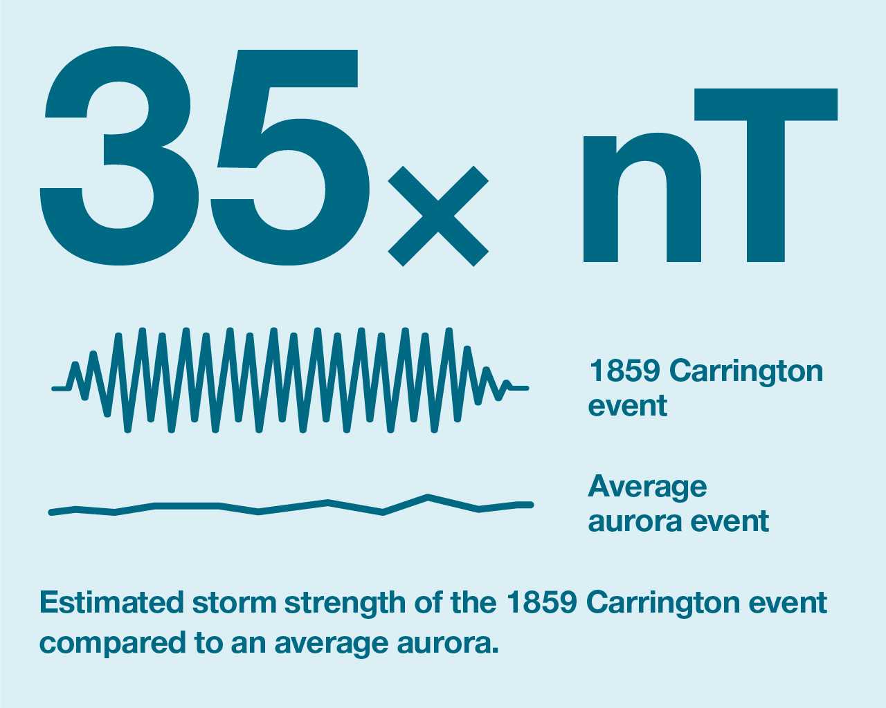
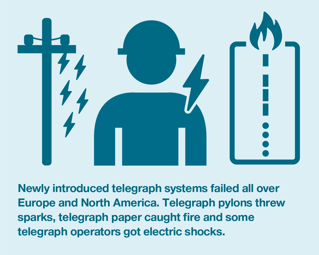
160 years ago, a powerful geomagnetic storm known as the Carrington Event occurred. Named after one of the British astronomers who observed and recorded it, the storm wrought havoc on the recently introduced telegraph systems with some telegraph operators experiencing electric shocks and equipment sparking.
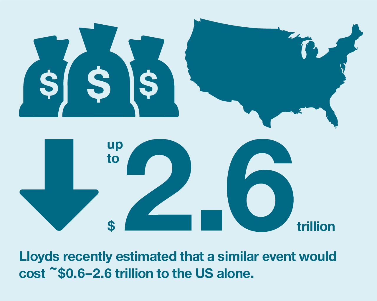
Lloyd’s estimated that if a severe geomagnetic storm on the same scale occurred today, electrical outages could occur that would take months to years to recover, with a total economic cost for North America alone, numbering in trillions of USD.
And in March 1989 a smaller geomagnetic storm caused a nine-hour blackout in Quebec.
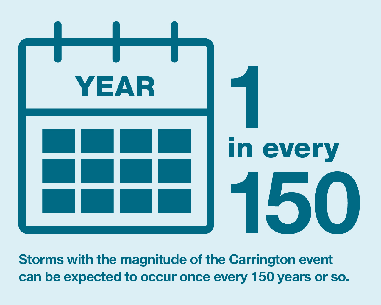
Although the probability of an extreme geomagnetic storm occurring is low, it is almost inevitable that one will occur eventually. Geomagnetic storms the size of the 1989 one occur roughly once every 50 years, while storms with the magnitude of the Carrington Event can be expected to occur once every 150 years or so.
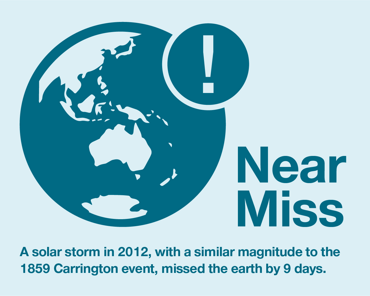
In fact, in 2012 the Earth experienced a “near miss” when a CME comparable to the one that caused the Carrington Event, tore through Earth’s orbit, but missed the Earth. If the erupting region of the Sun had been pointing directly towards the Earth, it would likely have had global effects.
What can we do to prepare for a geomagnetic storm? We monitor the Earth’s magnetic field.
The data we collect through our network of geomagnetic observatories allows governments and industry to prepare for and mitigate the impacts of geomagnetic storms.
We operate ten geomagnetic observatories: six on the Australian mainland, two in Antarctica, one on Macquarie Island and one in the Cocos Islands.
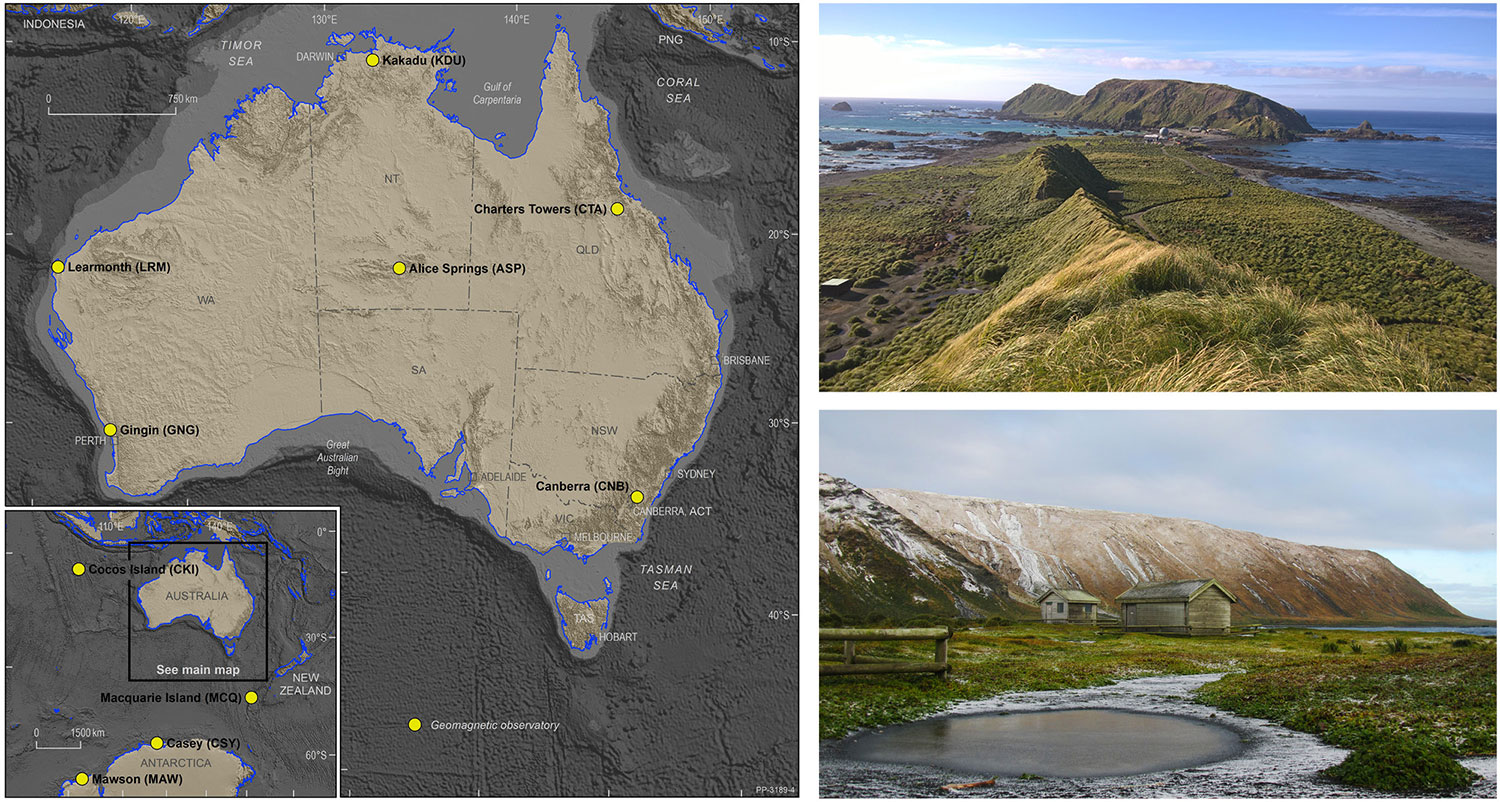
The locations of Geoscience Australia’s Geomagnetic Observatories. Top right: Macquarie Island Observatory and Station. Bottom right: Macquarie Island Observatory (MCQ)
Australia’s geomagnetic observatories form part of a global network, constantly monitoring the Earth’s magnetic field, recording changes second by second.
The magnetic field as measured at the surface of the Earth is composed of multiple sources.
- Most of the magnetic field is generated by the Earth’s core, and that component varies only very slowly over time.
- Other contributions come from the Earth’s crust, mostly due to magnetic minerals.
- More rapid variations are caused by space weather and electric currents in the upper parts of the Earth’s atmosphere, mostly resulting from variations in solar wind which also cause auroras.
Geomagnetic data can be used to gather information about all these sources, ranging in location from the Earth’s core to crust and upper atmosphere, and even detects the impacts of activity occurring at the surface of the sun.
Now we have the data, what do we do with it?
Having this data means we can do real-time continuous monitoring of perturbations in the magnetic field. This allows magnetic disturbances to be tracked and recorded, so effects on vulnerable infrastructure can be mitigated, to avoid the negative impacts of geomagnetic storms.
Geoscience Australia provides this geomagnetic data in real-time to the Bureau of Meteorology Space Weather Services and similar international agencies where it, along with other ground-based and space-based data, contributes to daily space weather forecasts. The ability to forecast large disturbances in advance allows the relevant parties to implement space weather mitigation plans where necessary. This may involve vulnerable infrastructure being switched off, or power being rerouted, while providing time to prepare response and recovery efforts, to resupply power in the shortest possible timeframe following the event.
We also use magnetic data from the observatory network to calibrate aircraft compasses, magnetic direction finding equipment and satellite magnetometers.
We produce mathematical models of the geomagnetic field, contributing to the International Geomagnetic Reference Field (IGRF) and the magnetic field model for the Australian region – which is referenced on topographic and aeronautical maps.
We also report on geomagnetic activity to contribute to global indices of magnetic activity, and monthly reports about rapid geomagnetic variations.
Finally, we conduct research to model Earth conductivity, which is important for predicting the impact space weather can have on large electrical conductors such as pipelines and power grids. Geomagnetic-induced currents in these large conductors depend on geomagnetic field variations and the geological conductivity of the area. Geoscience Australia’s research into Earth conductivity models provides a crucial understanding for properly preparing for the hazard posed by geomagnetic storms.
You can access our geomagnetic data through our website.
Andrew Lewis has worked in the geomagnetism team at Geoscience Australia for many years and represents Australia’s contribution to global geomagnetic monitoring on international scientific committees. He graduated with a masters degree in geophysics from University of Adelaide.