


New satellite data peels Australia's landscape bare
Geoscience Australia has stripped Australia's landscape bare through the first continent-scale, cloud-free spatial views of Australia's soil and rock cover.
The enhanced geological mapping from the national Landsat 8 Barest Earth mosaic is one of three new datasets added to the free-access National Map website. The other datasets include the Multi-Scale Topographic Position Index and Weathering Intensity Model.
Geoscience Australia's head of Mineral Systems, Dr Richard Blewett, said the new dataset is the result of trials to find the best way to map Australia's soil and rocks without 'noise' such as cloud cover and vegetation.
"These additions to the National Map are a prime example of how we can find innovative ways to explore Australia's mineral potential by combining satellite imagery and knowledge," Dr Blewett said.
"Through cross-disciplinary collaboration with our Exploring for the Future program, Digital Earth Australia, and collaborators at the Australian National University we have been trialling new applications on the National Map.
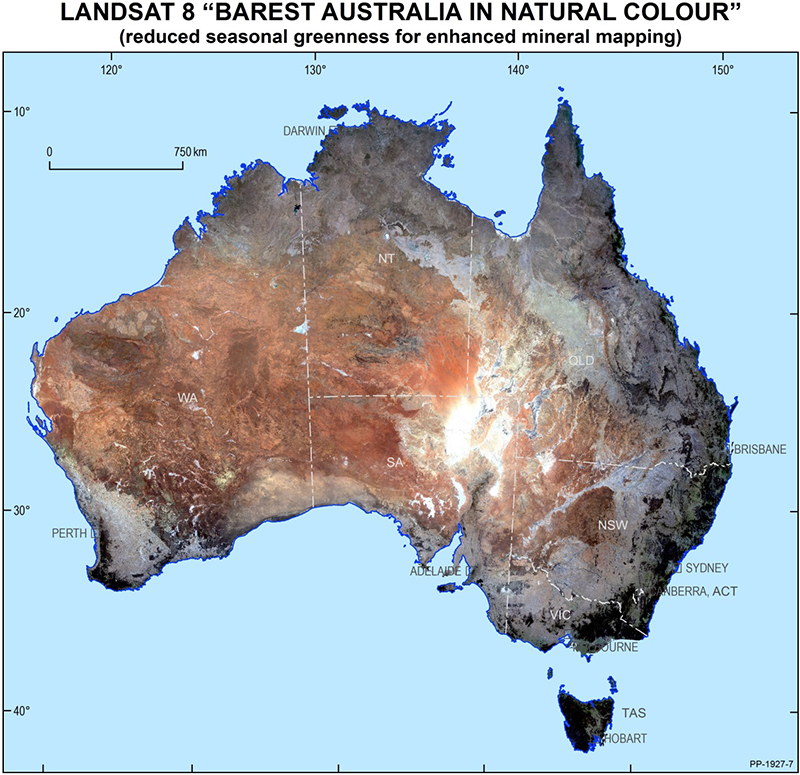
The national Landsat 8 Barest Earth mosaic accurately estimates the barest view of Australia based on soil and rock signatures.
"Our approach uses satellite data collected since 2013, to accurately estimate the barest view of Australia based on soil and rock signatures. The algorithm was applied to a petabyte-sized dataset using the National Computational Infrastructure, Australia's fastest super computer.
"The potential uses for this bare Earth data are vast - it is expected to provide enhanced geological mapping and assist mineral exploration, digital soil mapping, soil health assessments, land degradation monitoring, and environmental management.
"This dataset is particularly relevant for the current users of National Map, including the mineral exploration sector, academic researchers, the agriculture sector and environmental managers.
"It could also be used globally to map other countries that have similar satellite datasets to Australia.
"We are also releasing our Multi-Scale Topographic Position Image and the Weathering Intensity Model, which are both important in natural resource management.
"By having enhanced soil, topography and mineral properties mapped, our stakeholders can make informed decisions about how best to manage the land area they have an interested in."
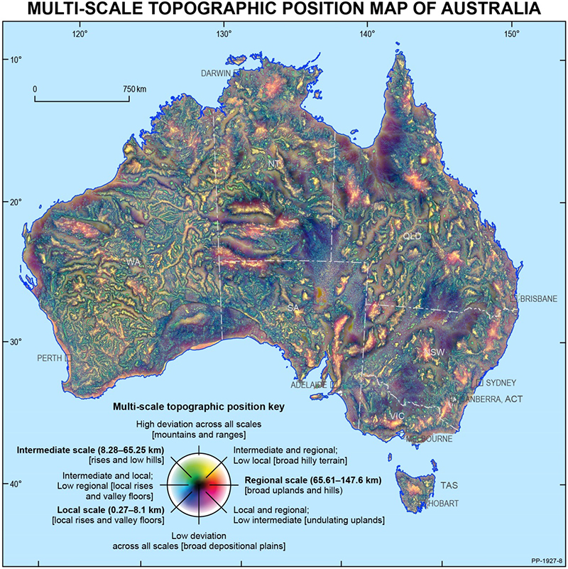
The Multi-Scale Topographic Position Image captures variations in topography from a digital elevation model.
Through the Multi-Scale Topographic Position Image, Geoscience Australia has captured variations in topography. The product is derived from a digital elevation model and gives a rich illustration of landform features. It has broad uses in understanding geomorphology and hydrology, along with mapping regolith and soils.
The Weathering Intensity Model shows the degree to which the surface or near-surface is weathered. The product has applications in mineral exploration and natural resource management.
All three datasets will be showcased at the Geoscience Australia booth at the Australian Geoscience Council Convention in Adelaide this week and are available on the National Map website.
Dr Blewett will also release copies of his jointly authored book "The Australian Continent". The text published by ANU Press and Geoscience Australia explores the geophysics of the Australian continent.
For more information about National Map see nationalmap.gov.au.
Exploring for the Future and Digital Earth Australia are programs under Geoscience Australia.

Weathering Intensity Model. Shows the degree to which the surface is weathered from unweathered or slightly weathered in blue to very highly weathered in red.