


String of large earthquakes shakes Queensland's east coast
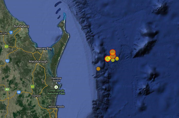
Location map showing three
magnitude 5 earthquakes and
numerous smaller earthquakes
that occurred between 30 July
and 1 August 2015 east of Fraser
Island, Queensland
For the second time in a matter of days residents along some of Queensland's most popular tourist destinations have been shaken by earthquakes.
Residents from Bundaberg to Brisbane and the Gold Coast were disturbed shortly after 1:30pm on Saturday 1 August by a magnitude 5.7 earthquakeoccurring approximately 120km offshore from Fraser Island. This was followed a little over an hour later by a magnitude 5.1 earthquake, again approximately 120km to the east of Fraser Island.
Shortly after both earthquakes the Joint Australian Tsunami Warning Centre operated by Geoscience Australia and the Bureau of Meteorology issued nil tsunami threats to Australia.
Saturday's earthquakes were in very similar locations to Thursday's magnitude 5.3 earthquake. Numerous magnitude 3 and 2 earthquakes have occurred in the same area over the past few days.
Geoscience Australia has received more than 3000 felt reports in response to the three magnitude 5 events.
Thursday's event caused minor damage to households, and caused buildings to be evacuated in the Brisbane CBD. All three earthquakes occurred more than 100km offshore, therefore avoiding major injury and damage to infrastructure.
Geoscience Australia senior duty seismologist Dan Jaksa said Australia has seen a number of these events where large earthquakes have happened in quick succession, the most famous being in Tennant Creek in 1988 when three earthquakes over magnitude 6 occurred within two hours of each other.
"We have seen this before in Queensland as well, when in 1918 the state experienced two strong quakes offshore of Gladstone, measuring magnitude 5.7 and 6.0 within a few hours of each other,"
"Saturday's magnitude 5.7 earthquake is the equal second strongest earthquake in recorded history in Queensland, behind the magnitude 6.0 event in 1918,"
"The earthquakes occurred because the Australian plate is moving northward at approximately seven centimetres per year, colliding with the Pacific plate, causing stress to build up across Australia, which is released periodically by earthquakes," Mr Jaksa said.
Did you feel the earthquakes?
If you have felt an earthquake in Australia please visit and share your experience. There is a simple online earthquake report formthat includes a series of questions to obtain information about shaking windows, loud noises or any immediate building damage. This information helps seismologists in gaining a greater understanding of this naturally occurring Earth process.
Follow us on Twitter @EarthquakesGA for all the latest earthquake information.
Further information: