
| the Christmas Island GIS online
|
| Roads | Natural Features | Built Environment | Contours and Spot Heights |
|
|
|
| Dataset | |
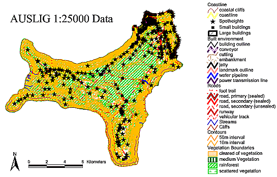
| Title | Auslig - 1:25000 Topography and Culture |
| Custodian | Australian Surveying and Land information Group, Dept. of Administrative Services, Canberra, ACT, Australia. |
| Jurisdiction | Australia |
| Description | |
| Abstract | AUSLIG data covers the whole island at a scale of 1:25000, and includes polygons, lines and points describing both natural and built environment. The AUSLIG data includes the following 1:25000 layers: roads, 10 metre contours, spot heights, buildings and other structures, hydrology, boundaries for the national park, boundaries for the mining leases and boundaries for four vegetation types. Licence / royalty arrangement pro forma were submitted by MREB for Territories Office and PRL in January 1996. |
| Search Word(s) | BOUNDARIES Administrative BOUNDARIES Cultural BOUNDARIES Mining BOUNDARIES National Parks CONTOURS Topographic HUMAN ENVIRONMENT Structures and Facilities VEGETATION Boundaries WATER Hydrology |
| Geographic Extent Name(s) | Christmas Island Edition 1 2010 1:30000 - Geoscience Australia GEOCAT 70145 |
| Data Currency | |
| Beginning Date | 01JAN1988 |
| Ending Date | 20AUG2002 |
| Dataset Status | |
| Progress | Complete |
| Maintenance and Update Frequency | Not Planned |
| Access | |
| Stored Data Format | DIGITAL - Arc/Info format in the Christmas Island Grid projection. ArcView3.1 shapefiles |
| Available Format Type | DIGITAL - Arc/Info format in the Christmas Island Grid projection. ArcView3.1 shapefiles |
| Access Constraint | Restricted. Maps produced and distributed beyond the licensee that include the AUSLIG data are required to carry the following acknowledgment (contact at AUSLIG is Ian Miller (02) 6201 4311):- Topographic data reproduced with permission of the General Manager, Australian Surveying and Land Information Group, Department of Administrative Services, Canberra, ACT. |
| Data Quality | |
| Lineage | The 1995 release of the AUSLIG digital data
for Christmas Island was published at the 1:25000 scale. For this
release the existing 1988 map was updated. The data was provided in
Arc/Info format in the Christmas Island Grid projection. Only 'feature
coded' data was available as AUSLIG do not see there being many sales
of this dataset. Feature coded data are the lowest level of release for
Arc/Info data by AUSLIG. There was basically no documentation with the
data - only a list of feature codes and their frequency. MREB have had
to re-work the data into its present form.
The original data was obtained as two Arc/Info export files (xmas.e00 and xmasrel.e00), containing general data and contour/spot-height data respectively. Considerable work was necessary to make this useful for the GIS. A series of Arc/Info macros similar to those applied to the CIA data were used to strip out different feature classes and build them as separate point, line or polygon coverages as appropriate. In generating polygon coverages cleaning was required. To suit use in Surpac mining software a version of the contours as polygons was created. The AUSLIG data are subject to copyright and MREB hold a licence. The road layer (.\data\infra_topo\topo25k\roads_25k.shp) was updated in June 2002 from a shapefile sent to GA from the Christmas Island Shire Council to include new and/or inaccurate road files. Street names within the Christmas Island Shire Council's shapefile were also added to the existing road_25k database. The updated version of the Christmas Island coastline
spatially aligns the coastline around the North-eastern side of the
island with a higher degree of accuracy. The "coast" shapefile found in
the "environment" directory was built using a union of Dola's Cadastre
and the original 1:25000 coastline. In September 2003 this dataset
was converted to the MGA(GDA94) projection using an x y shift (550015 =
x, 8780001 = y) on the CIG85 projection. |
| Positional Accuracy | Publication at the 1:25000 scale has important implications for the use of the AUSLIG topographic data. Some of the plots MREB have produced include enlargements to scales of 1:2000. This means the AUSLIG data are being displayed at over ten times its published scale. Users should view AUSLIG lines on such enlargements as representing a line around ten times as thick, the true line occurring somewhere within that much thicker line. It is far more expensive to capture data at small scales. As the data was originally intended to be used at 1:25000 scale, zooming in past this will show visible offset from the orthophotographs, potentially by as much as 25 metres. On zooming, the orthophotography will be more accurate, having error of at most 6 metres. A special case is the mining lease boundaries, which is superseded by the CIA mining lease data. The AUSLIG mining lease data should not be used. This superseded data is stored in the "defunct" subdirectory. It is provide to assist with verification and cross comparison with other mining lease boundary information users may acquire. |
| Attribute Accuracy | Not documented. |
| Logical Consistency | AUSLIG data covers the whole island, and includes polygons, lines and points describing both natural and built environment. |
| Completeness | The AUSLIG data set was complete and up to date at the time of publication. GA recognises that further work could be done to update and fine tune the dataset to yield a more error free and precise data set. |
| Contact Information | |
| Contact Organisation | AUSLIG |
| Contact Position | - |
| Mail Address | PO Box 2 |
| Locality | Beloconnen |
| State | ACT |
| Country | Australia |
| Postcode | 2609 |
| Telephone | (02) 6201 4222 |
| Facsimile | (02) 6201 4381 |
| Electronic Mail Address | datasales@auslig.gov.au |
| Metadata Date | 9-12-2003 |
| Additional Metadata | |
| Projection | UTM (WGS84) zone 48s |
| Printed | June 2012 |