
| the Christmas Island GIS online
|
|
|
|
| Dataset | |
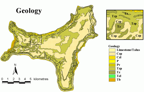
| Title | Geology map |
| Custodian | Geoscience Australia |
| Jurisdiction | Australia |
| Description | |
| Abstract | This dataset has been digitised from the 1:27400 1966 Geology map of Christmas Island. Geoscience Australia used ArcInfo to digitise a scanned version of the map. Once digitised the map was attributed according to the Geoscience Australia data dictionary guidelines. All information relating to geological boundaries and lineations/faults were extracted from the map and incorporated in the table. |
| Search Word(s) | GEOLOGY Boundaries GEOLOGICAL Features VEGETATION Boundaries |
| Geographic Extent Name(s) | Christmas Island Edition 1 2010 1:30000 - Geoscience Australia GEOCAT 70145 |
| Data Currency | |
| Beginning Date | 2001-10-26 |
| Ending Date | 2001-11-14 |
| Dataset Status | |
| Progress | Complete |
| Maintenance and Update Frequency | As Required |
| Access | |
| Stored Data Format | DIGITAL - ESRI Arc coverage |
| Available Format Type | DIGITAL - ESRI Shapefile DIGITAL - ESRI Arc coverage |
| Access Constraint | Restricted, see contact details below. |
| Data Quality | |
| Lineage | The map was originally created by J.Barrie in
1966 and later scanned and translated to the CIGIS projection. The map
was digitised by Geoscience Australia in late October 2001.
In September 2003 this dataset was converted to the
MGA(GDA94) projection using an x y shift (550015 = x, 8780001 =
y) on
the CIG85 projection. |
| Positional Accuracy | The positional accuracy of the scanned map is greater than the original it was digitised from. The "headsup" digitising process ensures that the original lines being digitised are many times larger than that of the printed map. |
| Attribute Accuracy | The attributes capture all information that is provided on the original map. By going through the Geoscience Australia QA & QC process ensures the fields are full and contain fields that further describe the map that were not on the hardcopy map itself. |
| Logical Consistency | The geology coverage is complete both spatially and non-spatially. The tables are well populated and describe all attributes and labels of the map. Spatially, all the geological linework present on the hardcopy map has been captured. |
| Completeness | This coverage is complete based on the nature of the original data. All spatial linework and non-spatial attribute data has been extracted from the original hardcopy map. All fields are populated to meet with Geoscience Australia's data standards. |
| Contact Information | |
| Contact Organisation | Geoscience Australia |
| Contact Position | - |
| Mail Address | Cnr Jerrabomberra Ave and Hindmarsh Drive |
| Locality | SYMONSTON |
| State | ACT |
| Country | Australia |
| Postcode | 2609 |
| Telephone | (02) 6249 9479 |
| Facsimile | (02) 6249 9983 |
| Electronic Mail Address | keith.porritt@ga.gov.au |
| Metadata Date | 9-12-2003 |
| Additional Metadata | |
| Projection | UTM (WGS84) zone 48s |
| Printed | June 2012 |