
| the Christmas Island GIS online
|
|
|
|
| Dataset | |
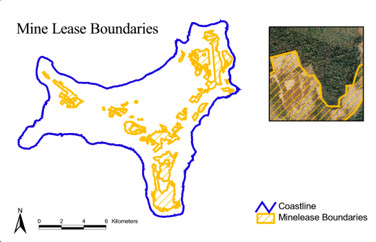
| Title | Mine Lease Boundaries |
| Custodian | Geoscience Australia |
| Jurisdiction | Australia |
| Description | |
| Abstract | Mining lease boudaries were supplied to Geoscience Australia
as many small polygons. Geoscience Australia merged all these polygons to form one
theme of mine lease boundaries. This data shows areas where mining of
phosphate has been approved. The mine lease theme is "mineleases.shp" and contains the following fields: Field Type Width Decimal |
| Search Word(s) | BOUNDARIES Administrative BOUNDARIES Cultural BOUNDARIES Mining HUMAN ENVIRONMENT Resources INDUSTRY Mining |
| Geographic Extent Name(s) | Christmas Island Edition 1 2010 1:30000 - Geoscience Australia GEOCAT 70145 |
| Data Currency | |
| Beginning Date | 1991 |
| Ending Date | 1998-12 |
| Dataset Status | |
| Progress | Complete |
| Maintenance and Update Frequency | As Required |
| Access | |
| Stored Data Format | DIGITAL - ESRI Shapefiles: Point, Line, Polygon |
| Available Format Type | DIGITAL - ESRI Shapefiles: Point, Line, Polygon |
| Access Constraint | Restricted, see contact details below. |
| Data Quality | |
| Lineage | In November 2002 the minelease boundaries were checked against the 2002 cadastral boundaries for discripencies. Minelease ML133A was updated from the 2002 cadastre - changes relate to airport land and a communications tower in the north. In October 2003 this dataset was converted to the MGA(GDA94) projection using an x y shift (550015 = x, 8780001 = y) on the CIG85 projection. |
| Positional Accuracy | Commisioning of the mine lease boundaries was
originally undertaken by AUSLIG. The Department of Minerals and Energy
W.A. (DOMEWA) is the designated authority for mine leases on Christmas
Island on behalf of the Commonwealth. In 1998 the Commonwealth allowed
an increase in the mine lease area up to the forest edge where the mine
lease abuts Crown land, but not where it abuts National Park. The mine lease boundaries supplied in the 1996 CIGIS were captured by AUSLIG W.A. from field visits in conjunction with the use of the 1987 aerial photography. These boundaries were set back from the forest edge. Subsequent changes to the mine lease data were supplied to AGSO in 1998 by the surveyor to PRL at the time (Russell Payne). This data came to AGSO as a series of ESRI shapefiles, each containing a mine lease polygon. These boundaries were produced by digitising off the orthophotography in conjunction with site visits. Geoscience Australia merged all individual polygons that were supplied into the one ESRI shapefile, so as to allow easier access to the data. |
| Attribute Accuracy | This metadata element is in progress. |
| Logical Consistency | This metadata element is in progress. |
| Completeness | This metadata element is in progress. |
| Contact Information | |
| Contact Organisation | Geoscience Australia |
| Contact Position | - |
| Mail Address | Cnr Jerrabomberra Ave and Hindmarsh Drive |
| Locality | SYMONSTON |
| State | ACT |
| Country | Australia |
| Postcode | 2609 |
| Telephone | (02) 6249 9479 |
| Facsimile | (02) 6249 9983 |
| Electronic Mail Address | keith.porritt@ga.gov.au |
| Metadata Date | 9-12-2003 |
| Additional Metadata | |
| Projection | CIG85 |
| Printed | June 2012 |