
| the Christmas Island GIS online
|
|
|
|
| Dataset | |
| Title | Register of National Estate |
| Custodian | Environment Australia |
| Jurisdiction | Australia |
| Description | |
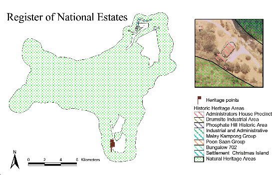
| Abstract | Data were provided to Geoscience Australia by Environment
Australia - Register of the National Estate and contain natural and
historical heritage data (point and polygon) for Christmas Island.
Heritage data are in both points and polygon form. There are currently
4 records in the heritage points theme and 61 records in the natural
and heritage themes. Geoscience Australia noted that in a previous version of the
heritage points theme there are 38 registed points in comparison to the
4 in the new dataset.
These two polygon datasets that were supplied have been separated into two shapefiles, 'natural heritage' and 'historic heritage' respectively. Natural data encompasses natural features including some areas of pinnalce fields and extends offshore. Historic heritage data is comprised of features that are of manmade origin and that are of historic significance. These features include the cantilevers, the Christmas Island Administrators house, and some others. |
| Search Word(s) | HUMAN ENVIRONMENT Structures and Facilities HUMAN ENVIRONMENT Urban Design LAND Use |
| Geographic Extent Name(s) | Christmas Island Edition 1 2010 1:30000 - Geoscience Australia GEOCAT 70145 |
| Data Currency | |
| Beginning Date | Not Known |
| Ending Date | 2001-05-07 |
| Dataset Status | |
| Progress | Complete |
| Maintenance and Update Frequency | As Required |
| Access | |
| Stored Data Format | DIGITAL - ArcView Shapefiles: Point, Polygon |
| Available Format Type | DIGITAL - ArcView Shapefiles: Point, Polygon |
| Access Constraint | Restricted, see contact details below. |
| Data Quality | |
| Lineage | Data were provided to Geoscience Australia via an email from
Environment Australia. Projection of supplied data is geographic
(WGS72)/decimal degrees. No other metadata was supplied by RNE.
GA then projected the data to Christmas Island Grid 1985 (CIG85). With the apparent low resolution of the polygon natural heritage data, they were found to compare well to the AUSLIG 1:25000 features. The historic heritage data appears to be of higher resolution (polygon data consists of building outlines) but does not overlay with the orthophotography or cadastre. As a result of this GA shifted these data by 16.5 metres westward to match existing data. The polygon data was then all merged together, but because of polygon overlap natural heritage data was converted into its own shapefile. The heritage data is now presented as points data and polygons named historic and natural heritage data. In September 2003 this dataset was converted to the MGA(GDA94) projection using an x y shift (550015 = x, 8780001 = y) on the CIG85 projection. |
| Positional Accuracy | The overall accuracy of the merged data is correct to approximately 3 metres. In the case of the original historic data, comparisons made against orthophotography found a difference of 16.5m. The coastline of the natural heritage data closely matches the form of the AUSLIG 1:25000 data so positioned to this. |
| Attribute Accuracy | Not documented from source, but all fields are full and because the data is concerned with heritage items most of the fields contain names and locations. The fields name, class and staus appear to be most beneficial to users as they describe the name of the heritage feature, the class they are in, and whether the feature is registered or not. |
| Logical Consistency | These data supplied by Environment Australia contain fields that follow logical data structure and consistency. All points and polygons have a name, class, registered number (from Register of National Estate of Environment Australia) and a location. |
| Completeness | These data covers the whole island, however all items of historical heritage are located in the North East of the island. The natural heritage polygon covers the entire island and extends offshore. |
| Contact Information | |
| Contact Organisation | Geoscience Australia |
| Contact Position | - |
| Mail Address | Cnr Jerrabomberra Ave and Hindmarsh Drive |
| Locality | SYMONSTON |
| State | ACT |
| Country | Australia |
| Postcode | 2609 |
| Telephone | (02) 6249 9479 |
| Facsimile | (02) 6249 9983 |
| Electronic Mail Address | keith.porritt@ga.gov.au |
| Metadata Date | 9-12-2003 |
| Additional Metadata | |
| Projection | UTM (WGS84) zone 48s |
| Printed | June 2012 |