
| the Christmas Island GIS online
|
|
|
|
| Dataset | |
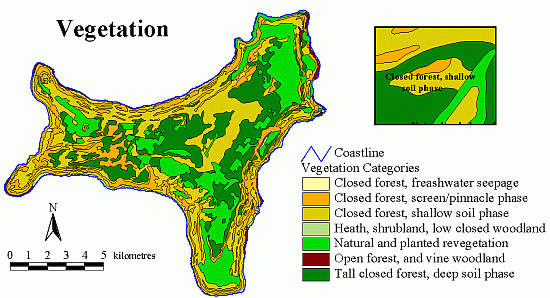
| Title | Vegetation |
| Custodian | Geoscience Australia |
| Jurisdiction | Australia |
| Description | |
| Abstract | This dataset has been digitised from the
1:25000 vegetation map of Christmas Island (accompanying Mitchell's
1985 report). The vector version was completed on behalf of Parks
Australia Christmas Island. Geoscience Australia used ArcInfo to
'heads-up' digitise a scanned version of the map. Once digitised the
arcs were built into polygons and the map was attributed based on the
Geoscience Australia data dictionary guidelines. All information
relating to vegetation boundaries was extracted from the map and
incorporated in the table. The fields that were used follow:
Alias Type Width Decimal |
| Search Word(s) | BOUNDARIES Administrative BOUNDARIES National Parks FORESTS Natural VEGETATION Boundaries |
| Geographic Extent Name(s) | Christmas Island Edition 1 2010 1:30000 - Geoscience Australia GEOCAT 70145 |
| Data Currency | |
| Beginning Date | 2001-10-10 |
| Ending Date | 2002-02-20 |
| Dataset Status | |
| Progress | Complete |
| Maintenance and Update Frequency | Not planned |
| Access | |
| Stored Data Format | DIGITAL - ESRI Arc coverage |
| Available Format Type | DIGITAL - ESRI Shapefiles DIGITAL - ESRI Arc coverage |
| Access Constraint | Restricted, see contact details below. |
| Data Quality | |
| Lineage | The map originally accompanied Mitchell's
1985 report, and was based on the geology and topography map of
Christmas Island by J. Barrie in 1966. This map was scanned and
translated to the CIG85 projection.
The scanned map was included in the Christmas Island GIS. It was digitised by Geoscience Australia in mid October 2001 on behalf of Parks Australia North Christmas Island. Newveg.shp is the revised version of Vegetation.shp. Dr. Pete Green a Research Fellow from EA created this .shp file by taking the original vegetation file, making all the vegetation types semi-transparent, and superimposing this theme over a composite aerial photograph of the island (Christmas.ers, generated from the 1987 aerial photos). Dr. Green then adjusted the position of the clearing boundaries (category SV) around all previously mined fields, expanded these polygons to include all major roads, and added and subtracted polygons as required. In all cases Dr. Green tried to pick the original boundary of the clearing - there has been substantial regrowth around the borders of some mined fields, but this regrowth can be distinguished from the adjacent forest by its more regular canopy. Dr. Green made a concerted effort to ONLY adjust the position of forest/clearing boundaries, and NOT forest/forest boundaries. The aerial photos are excellent for judging the position of the former, but we have no prior evidence for adjusting the latter - as far as Dr. Green knows, the positions of forest/forest boundaries have never been ground-truthed. Where boundaries were indistinct on Christmas.ers, Dr. Green occasionally made reference to two sets of black and white aerial photographs of the island taken in 1976 and 1981. In September 2003 this dataset was converted to the MGA(GDA94) projection using an x y shift (550015 = x, 8780001 = y) on the CIG85 projection. |
| Positional Accuracy | The positional accuracy of the scanned map is
greater than the Mitchell's 1985 map it was digitised from. The
"headsup" digitising process ensures that the original lines being
digitised are many times larger than that of the printed map.
Mitchell's (1985) hand-drafted vegetation map for Christmas Island has
several inaccuracies;
1. Major roads were not considered - forest is often drawn as continuous across roads. 2. The boundaries of clearings are inaccurate, sometimes up to one or two hundred meters. 3. Some small, isolated forest blocks have been omitted. In addition, the accuracy of the forest/clearing boundaries of the newveg.shp will depend on how closely Dr. Green zoomed in on Christmas.ers. Dr. Green adjusted most boundaries when working at a scale of 1;1000 to 1:1500, but occasionally had to work at greater scales than this. In some areas (e.g. Field 25, and the area around the sports ground) the 1987 aerial photos are of particularly poor quality (shadows, distortion etc) and it was sometimes difficult to distinguish boundaries. |
| Attribute Accuracy | The attributes capture all information that is provided on the original map. |
| Logical Consistency | The geology coverage is complete both spatially and non-spatially. The tables are well populated and describe all attributes and labels of the map. Spatially, all the vegetation linework present on the hardcopy map has been captured. |
| Completeness | This coverage is complete based on the nature of the original data. All spatial linework and non-spatial attribute data has been extracted off the original hardcopy map. All fields are populated to meet with Geoscience Australia's data standards. |
| Contact Information | |
| Contact Organisation | Geoscience Australia |
| Contact Position | - |
| Mail Address | Cnr Jerrabomberra Ave and Hindmarsh Drive |
| Locality | SYMONSTON |
| State | ACT |
| Country | Australia |
| Postcode | 2609 |
| Telephone | (02) 6249 9479 |
| Facsimile | (02) 6249 9983 |
| Electronic Mail Address | Keith.Porritt@ga.gov.au |
| Additional Contact Information | |
| Contact Organisation | Parks Australia North |
| Contact Position | Research Fellow - Peter Green |
| Mail Address | PO Box 867 |
| Locality | Christmas Island |
| State | Indian Ocean |
| Country | Australia |
| Postcode | 6798 |
| Telephone | - |
| Facsimile | - |
| Electronic Mail Address | Peter.Green@ea.gov.au |
| Metadata Date | 9-12-2003 |
| Additional Metadata | |
| Projection | UTM (WGS84) zone 48s |
| Printed | June 2012 |