
| the Christmas Island GIS online
|
|
|
|
| Dataset | |
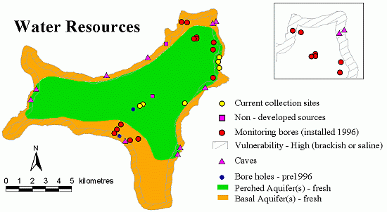
| Title | Water Resources |
| Custodian | Ecowise |
| Jurisdiction | Australia |
| Description | |
| Abstract | This dataset are related to all facets of
water
on Christmas Island. This document seeks to provide a description of the Water Resources GIS data layers that have been compiled by ECOWISE Environmental as part of the Christmas Island Groundwater investigations and monitoring report (EHYD 99/17). This report was prepared for GHD Pty Ltd and Christmas Island Administration by Tony Falkland, ACTEW Corporation Ltd 1999. The GIS data and mapping developed for this report was complied by Vince Hazell and Steve Grey from ECOWISE Environmental Pty Ltd. The following data layers have been collated on a CD in ArcView shapefile format:
As required, outputs of this project include:
|
| Search Word(s) | CLIMATE AND WEATHER Resources GEOSCIENCES Hydrogeology WATER WATER Groundwater WATER Hydrology WATER Lakes WATER Rivers WATER Quality |
| Geographic Extent Name(s) | Christmas Island Edition 1 2010 1:30000 - Geoscience Australia GEOCAT 70145 |
| Data Currency | |
| Beginning Date | Not Known |
| Ending Date | 1999 |
| Dataset Status | |
| Progress | Complete |
| Maintenance and Update Frequency | As Required |
| Access | |
| Stored Data Format | DIGITAL - ESRI Shapefiles: Point, Line,
Polygon |
| Available Format Type | DIGITAL - ESRI Shapefiles: Point, Line, Polygon |
| Access Constraint | Restricted, see contact details below. |
| Data Quality | |
| Lineage | Metadata element still in progress |
| Positional Accuracy | Metadata element still in progress. |
| Attribute Accuracy | Metadata element still in progress. |
| Logical Consistency | Metadata element still in progress |
| Completeness | Metadata element still in progress. |
| Contact Information | |
| Contact Organisation | Geoscience Australia |
| Contact Position | - |
| Mail Address | Cnr Jerrabomberra Ave and Hindmarsh Drive |
| Locality | SYMONSTON |
| State | ACT |
| Country | Australia |
| Postcode | 2609 |
| Telephone | (02) 6249 9479 |
| Facsimile | (02) 6249 9983 |
| Electronic Mail Address | keith.porritt@ga.gov.au |
| Metadata Date | 9-12-2003 |
| Additional Metadata | |
| Projection | UTM (WGS84) zone 48s |
| Printed | June 2012 |