|
Cocos Island 2011 Orthophotography |
|
|
| Dataset | |
| Title | Cocos Island 2011 Orthophotography |
| Custodian | Geoscience Australia |
| Jurisdiction | Australia |
| Description | |
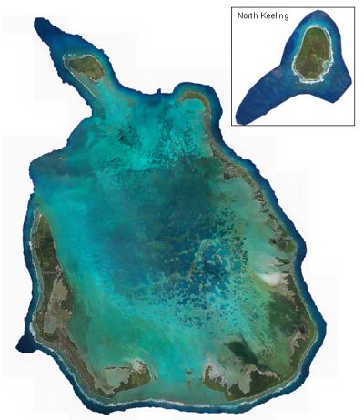
| Abstract | Between the 8th and 16th of August 2011 aerial photography of Cocos (Keeling) Islands was obtained by AAM using light aircraft. The imagery has a 15cm on ground pixel size resolution. This metadata sheet refers to the orthophotography mosaic of the Cocos southern atoll (Cocos_2011_orth.ecw) and of North Keeling (N_Keeling_2011_orth.ecw). AAM also provided the imagery to Geoscience Australia as 1km ecw and tiff tiles, along with the raw non-georeferenced images. Only the full mosaic is provided in the Cocos GIS package. Other data can be requested from Geoscience Australia. |
| Search Word(s) | PHOTOGRAPHY AND IMAGERY Aerial PHOTOGRAPHY AND IMAGERY Plan |
| Geographic Extent Name(s) | Cocos (Keeling) Islands Edition 1 2010 1:25000 - Geoscience Australia GEOCAT 70146 |
| Data Currency | |
| Beginning Date | 8 August 2011 |
| Ending Date | 16 August 2011 |
| Dataset Status | |
| Progress | Complete |
| Maintenance and Update Frequency | Not planned |
| Access | |
| Stored Data Format | DIGITAL - TIFF/ECW |
| Available Format Type | DIGITAL - TIFF/ECW |
| Access Constraint | None |
| Data Quality | |
| Lineage | In 2011 AAM was commissioned by the Commonwealth
to obtain orthophotography of Cocos (Keeling) Islands. The survey was carried out using a fixed wing aircraft between the 8th and 16th of August
2011. All imagery was captured using a DiMAC UltraLight 50mmm Lens camera within approximately 2 hours of low tide. During this period
tides ranged from 0.4m to 1.3m.
The photo frame and tide height table
lists the approximate tide height for each raw photo.
Using an automated process, raw images were joined to form two mosaics, one of the Cocos southern atoll and one of North Keeling island.
Colour balancing and replacement of certain areas with alternate raw images was performed for consistency.
The imagery has a 15cm on ground resolution. For a detailed description of the aerial survey data please see the AAM Survey Report.
The orthophotography was provided to Geoscience Australia in GDA94. It has been converted to UTM WGS 84 zone 47s using ESRI ArcMap. |
| Positional Accuracy | As a guide, the orthophotography is horizontally accurate to 30cm. |
| Attribute Accuracy | Not Relevant |
| Logical Consistency | Not Relevant |
| Completeness | Complete. |
| Contact Information | |
| Contact Organisation | Geoscience Australia |
| Contact Position | Keith Porritt |
| Mail Address | Cnr Jerrabomberra Ave and Hindmarsh Drive |
| Locality | SYMONSTON |
| State | A.C.T |
| Country | Australia |
| Postcode | 2601 |
| Telephone | (02) 6249 9479 |
| Facsimile | (02) 6249 9971 |
| Electronic Mail Address | Keith.Porritt@ga.gov.au |
| Metadata Date | 8-3-2012 |
| Additional Metadata | |
| Projection | UTM (GDA94) zone 47s |