Geochronology
Page last updated:27 June 2022
What is geochronology?
Geochronology is a discipline of geoscience which measures the age of earth materials and provides the temporal framework in which other geoscience data can be interpreted in the context of Earth history. Much of the geochronology work at Geoscience Australia supports basic geological mapping and developing our understanding of the geological history of the continent over millions and billions of years. This knowledge helps to answer questions such as when did a volcano last erupt, what is the rate of crustal uplift in a specific area, are rocks at one gold prospect the same age as those at another or does the age of a dune fields align with the known climate record.
Australia is an old continent and the age of much of its geology predates fossil evidence and must be dated by radiometric geochronology methods which provide absolute ages of Earth materials using radioactive decay. There is a wide variety of materials which can be analysed and Australian researchers continue to be at the forefront of developing instruments and methods for geochronology.
The basis of radiometric geochronology is that a radioactive parent element, such as uranium, is incorporated as trace amounts into a mineral when it forms in the Earth's crust. Over time that parent element will decay to a stable daughter element, such as lead, which ideally will be locked inside the mineral. By measuring the amount of the parent and daughter elements in a sample and applying the known rate of decay for that radioactive parent, the age at which the mineral formed can be calculated.
How does geochronology help exploration for resources?
Often, the most basic knowledge required for resource exploration is the age of rocks in a given area, regardless of whether the resource is mineral, petroleum or geothermal. The rock ages provide information about how the rocks are related and what geological events of which they may have been part.
On a more detailed level, geochronology can help focus exploration strategies by:
- Providing the age at which igneous rocks were extruded onto the surface or intruded into other rocks. Some types of mineralisation occur in association with igneous activity so understanding the age of activity can help focus where these systems might be found.
- Providing the timing of metamorphic events which alter existing rocks. The movement of fluids and mineral changes which occur with metamorphism also causes mineralisation and unravelling the complex geological history of these events can provide important information for exploration.
- Constraining the depositional ages and provenance of the sedimentary rocks which host mineral and energy resources. This provides information about how old the host rocks are and even the geographic arrangements of mountains and continents when the sediments were deposited.
- Correlating sedimentary layers within and between basins which can help map the potential extent of resources such as petroleum, coal or gas.
- Specialised geochronology techniques can provide data about the thermal history of a region or basin to help establish when certain minerals reached a particular temperature in the past. This can be vital information to understand whether organic material in a basin was suitably 'cooked' to form coal or petroleum.
Directly dating mineralisation can be difficult because the nature of the mineralising event itself can disrupt how parent and daughter elements are retained in minerals, making subsequent analysis unreliable. A growing number of specialist techniques can be applied in certain situations, but most geochronology remains focused on supporting our basic understanding of geological history.
Geochronology at Geoscience Australia
Geoscience Australia provides high quality age information to support research objectives in regional and specific interest projects. Collaborative projects operate with the states and Northern Territory Geological Surveys, universities and the CSIRO.
Geoscience Australia's Geochronology Laboratory consists of a world-class mineral separation facility supporting a Sensitive High Resolution Ion MicroProbe (SHRIMP) instrument which provides in-house analysis of mineral phases such as zircon and monazite. The laboratory is able to completely manage the 'outcrop-to-publication' analytical cycle which ensures that the highest quality data are provided to research projects. The in-house facility also aids the development of new analytical methods, expanding Geoscience Australia's capability to address increasingly complex geoscience issues. The laboratory also has a strong network of relationships with geochronology laboratories around the world which enables access to a range of analytical methods such as argon-argon (Ar-Ar) and thermal ionisation mass spectrometry uranium-lead (TIMS U-Pb).
Geoscience Australia and its predecessor organisations have been involved in geochronological studies of Australia for more than 30 years and have acquired a large dataset from all over the continent, including some samples from the continental shelf. These data are of various vintages and standards and Geoscience Australia is in the process of upgrading its geochronology data systems to meet emerging requirements for interoperability.
What is the Sensitive High Resolution Ion Microprobe?
The SHRIMP (Sensitive High Resolution Ion Microprobe) analyses mineral grains by focussing a microbeam of ionised oxygen into a spot on the surface of the grain. Atoms in the mineral are blasted off the surface and extracted for measurement. The spot is typically 20 to 30 microns in diameter, with a micron being one-thousandth of a millimetre and the size of a fullstop on a printed page typically being around 250 microns.
The SHRIMP, which weighs 12 tonnes and is six metres in length is a triumph of Australian research, design and engineering. Development began at Australian National University in 1974 and have been sold to laboratories all around the world including Canada, Japan, USA, China, Russia, South Korea, Brazil and Spain. The SHRIMP is built by Australian Scientific Instruments in Fyshwick, Canberra.
Further information about the SHRIMP can be found at the Australian Scientific Instruments website.
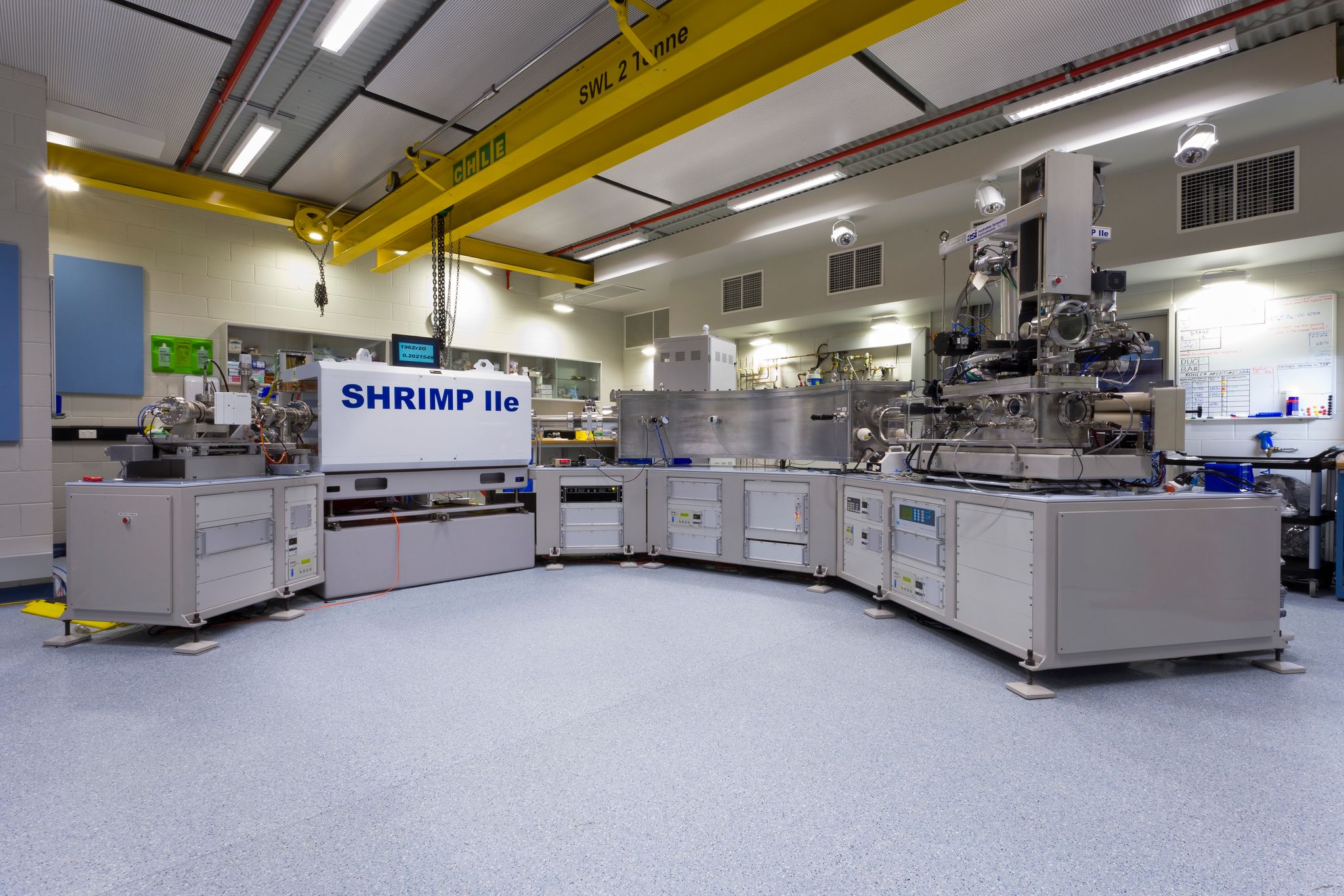
The SHRIMP (Sensitive High Resolution Ion Microprobe)
Geochronology and isotopes data portal
Geoscience Australia has developed a Geochronology and Isotopes Data Portal that provides easy access to compilations of:
- publicly-available radiometric age results and
- full analytical data tables for publicly-available isotope data, from both Geoscience Australia and literature-compiled sources as well as suite of analytical tools to maximise the value of the data.
Each result links to information about the sample (including unit name, lithology and age), sample collection site, method of analysis, analytical errors, associated Reference Standards and analytical values (full analytical datasets only), and references for location, age data, and the source publication information.
The geochronology and isotope data has also been published as a Web Mapping Service. The Web Mapping Service can be added to GIS software packages or used to develop spatial applications. The Geochronology and Isotopes Data Portal and Web Mapping Service are automatically updated when new data becomes available.
A summary of the datasets available in the Geochronology and Isotopes Data Portal can be found in the table below.
It is recommended that the Geochronology and Isotopes Data Portal be cited as: Geoscience Australia 2021. Geochronology and Isotopes Data Portal, accessed day Month Year.
It is recommended that the Geochronology And Isotopes Web Mapping Services be cited as: Geoscience Australia 2021. Geochronology and Isotopes Web Mapping Service, accessed day Month Year.