Centre of Australia States and Territories
Page last updated:11 January 2019
Overview
Officially, there is no centre of Australia. This is because there are many complex but equally valid methods that can determine possible centres of a large, irregularly-shaped area - especially one that is curved by the earth's surface. However, numerous attempts at reaching and defining Australia's centre were made during the country's early pioneering days:
Let any man lay the map of Australia before him, and regard the blank upon its surface, and then let me ask him if it would not be an honourable achievement to be the first to place foot at its centre. Men of undoubted perseverance and energy in vain had tried to work their way to that distant and shrouded spot.
Thus said Charles Sturt in November 1845, who at the age of forty-nine, and partially blind from earlier expeditionary work, left his beloved wife Charlotte and started on a third and final expedition - this time aimed straight at the heart of the continent. There, he believed he would find 'a large body of inland waters', so he equipped the expedition with a boat for sailing on this mythical sea. Instead, he discovered a sea of seemingly endless sand dunes - the Simpson Desert - and temperatures so extreme they shrivelled his supplies, prostrated his horses and burst his thermometer.
I looked upon Central Australia as a legitimate field, to explore which no man had a greater claim than myself.
Whilst drought and extreme heat thwarted Sturt's attempts, little did he envisage that one of his party, John McDouall Stuart would instead, sixteen years later, claim the mantle of reaching the geographic centre.
Sunday, 22 April 1860, Small Gum Creek, under Mount Stuart, Centre of Australia - today I find from my observations of the sun, 111° 00' 30", that I am now camped in the centre of Australia. I have marked a tree and planted the British flag there.
T. Flannery (ed.), The Explorers, The Text Publishing Company, Melbourne, 1998
Five possible centre points of Australia
Over time and with ingenuity, several other methods for calculating the possible centre of mainland Australia have been developed. Covered in more detail below, the results enclose an area which includes the town of Alice Springs and the MacDonnell Ranges, two icons of central Australia.
For the states and territories, we have used a simple conical projection, and reprojected the coordinates using the Australian Geodetic Datum (AGD66) and ArcInfo Software by ESRI. The results are compatible with most paper maps currently in use, but are based only on the mainland areas of each State and Territory.
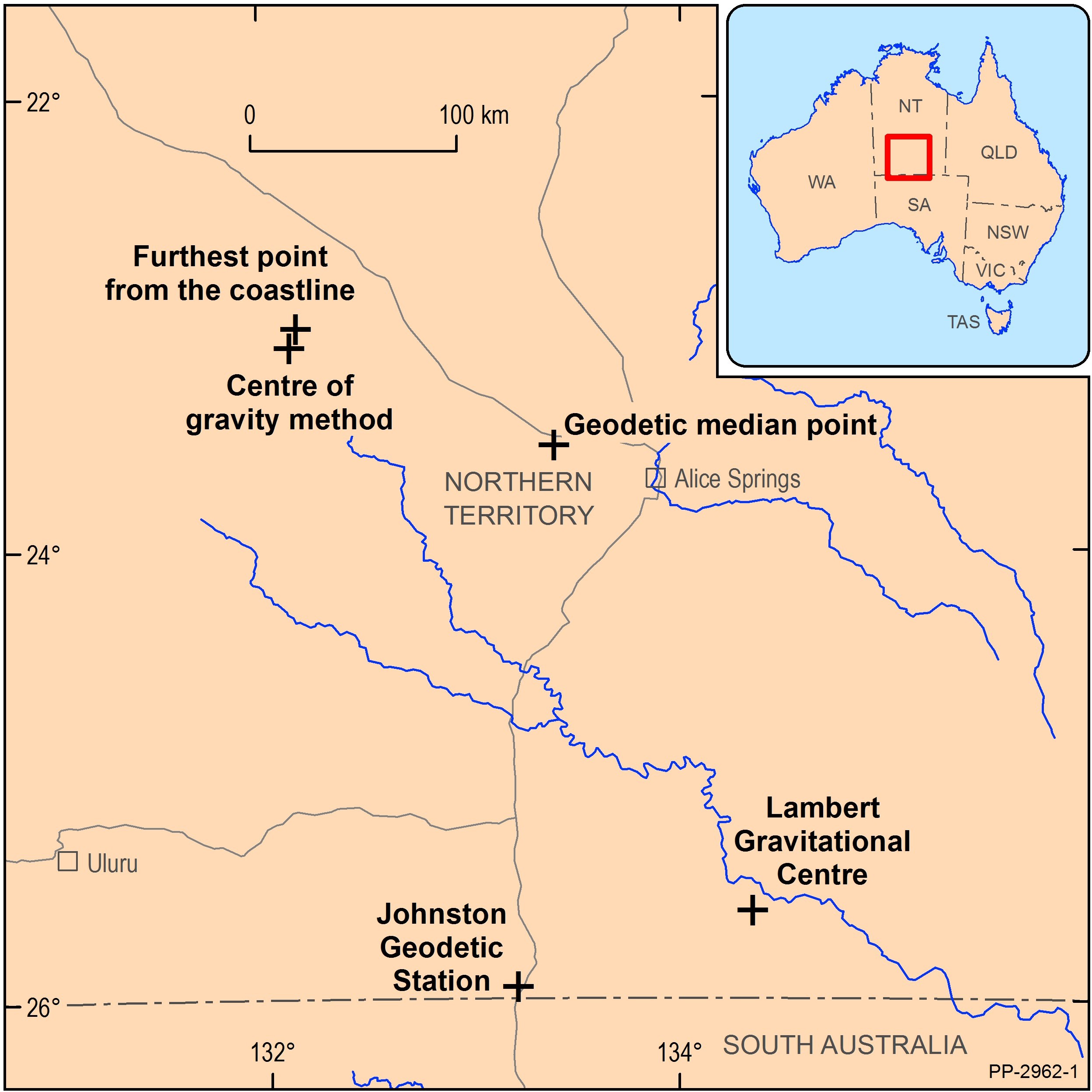
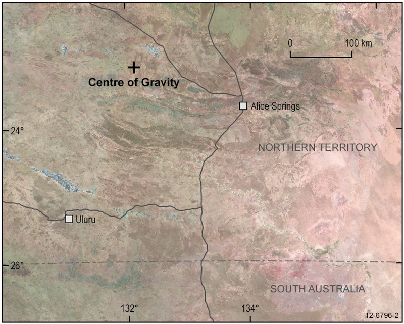
Centre of gravity method
More than 50,000 digitised points representing the coastline of mainland Australia were assigned a unit weight. The moments were calculated assuming equal units of latitude and longitude, the latter varying with the cosine of latitude. So what does all this mean? Imagine you had a perfect cut-out of Australia, with thousands of tiny weights distributed along the perimeter. The centre would be the place where you could balance the cut-out on a pin, and it would be perfectly horizontal. The results for this method would be:
23° 07' South, 132° 08' East; position on SF53-13 Hermannsburg 1:250 000 and 5351 Glen Helen 1:100 000 scale maps.
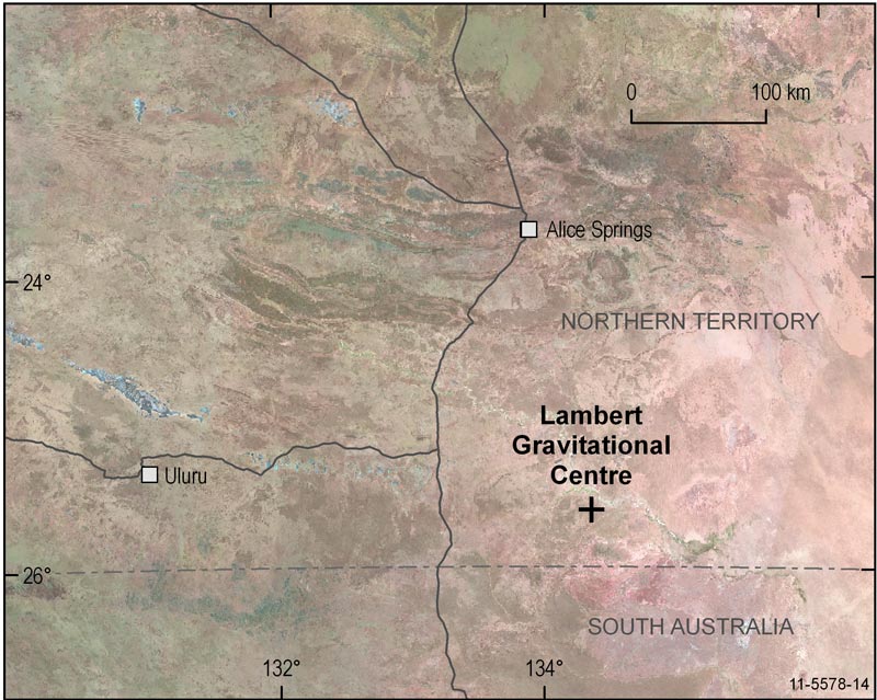
Lambert gravitational centre
In 1988 the Royal Geographical Society of Australasia determined, as a Bicentennial project, the geographical centre of Australia. A monument was erected to mark the location and named in honour of Dr. Bruce P Lambert, a former Director of the Division of National Mapping, for his achievements in the national survey, levelling and mapping of the continent. Similar to the centre of gravity method, the location was calculated from 24 500 points at the high water mark of Australia's coastline.
In the 1930s when Dr C.T. Madigan travelled through Central Australia he calculated the centre of gravity by using a metal cut-out of Australia with a plumb bob and string. His crude measurement was surprisingly accurate as he selected a point less than 11 kilometres due west of this present position.
The computed result of the 1988 project was:
25° 36' 36.4" South, 134° 21' 17.3" East; position on SG53-06 Finke 1:250 000 and 5746 Beddome 1:100 000 scale maps.
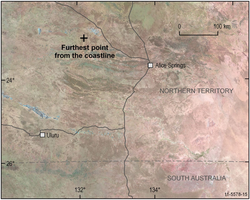
Furthest point from the coastline
A series of concentric circles drawn on transparent material were moved over the top of a 1:5 million scale map of Australia until one circle was found to touch the coast at three points. Think of it as the largest perfect circle that could be drawn anywhere inside Australia that only just touches the coastlines. The centre of the circle was then marked and the coordinates scaled from the map. This method resulted in a good agreement with the centre of gravity procedure. This is remarkable, and due to Australia's shape rather than any general rule of correlation between the two methods.
23° 02' South, 132° 10' East; position on SF53-13 Hermannsburg 1:250 000 and 5351 Glen Helen 1:100 000 scale maps.
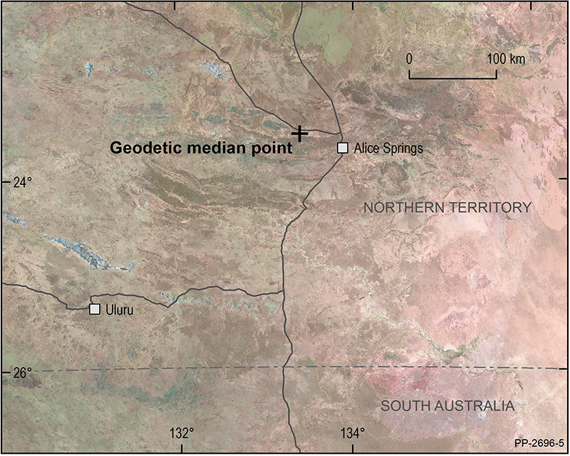
Geodetic median point
The geodetic median point was calculated as the midpoint between the extremes of latitude and longitude of the continent. Basically what this means is that a box was drawn around Australia, just touching the northern, eastern, southern, and western-most points on the mainland of the continent. The geodetic median point is the location of the intersection the two geodesic lines joining the four corners. A geodesic is the shortest line between two points on an ellipsoid. The geodetic median point will be the point where the ellipsoidal distance of the four geodesic lines joining the median point to each corner will be the same. Vincenty's formulae was used to compute the value of the equidistant ellipsoidal distance on the GRS80 ellipsoid, which came to 2,576,291.952 metres. What's interesting though is this; both this method and the furthest point from the coastline method produce coordinates that are within the ball-park of the other weighted methods. That means that despite the irregular coastline, Australia's distinctive shape actually has a relatively high degree of symmetry.
23° 33' 09.89" South, 133° 23' 46.00" East; position on SF53-13 Hermannsburg 1:250 000 and 5551 Amburla 1:100 000 scale maps.
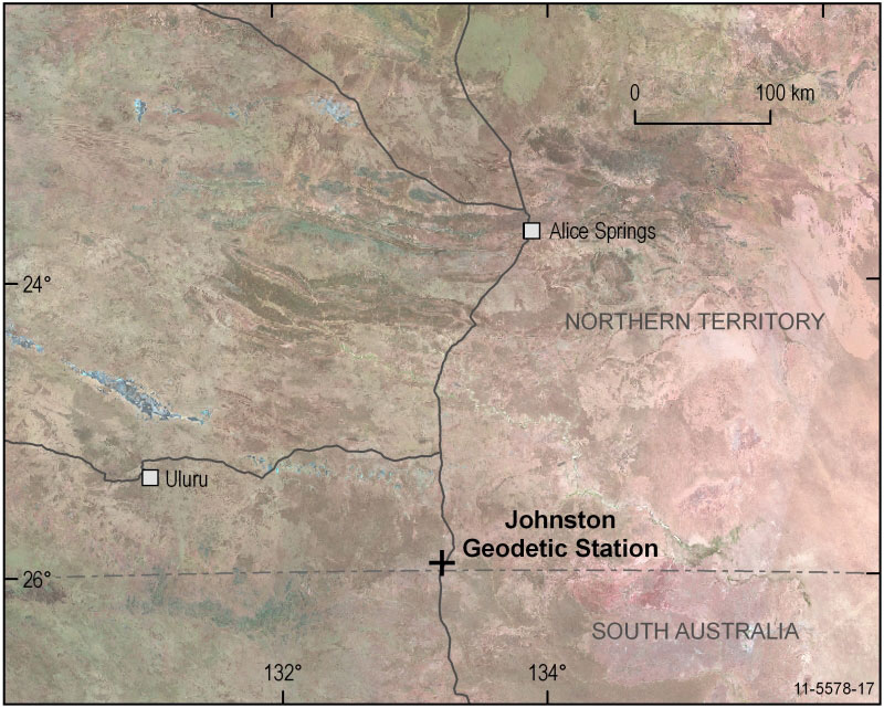
Johnston Geodetic Station
This trigonometric survey cairn, situated about one kilometre north of Mt Cavenagh Homestead, was built by officers of the Division of National Mapping in 1965, and was once the central reference point for all Australian surveys. It was named after Fredrick Marshall Johnston, former Commonwealth Surveyor General and the first Director of National Mapping. Today, surveys are based on the Geocentric Datum of Australia (GDA), a new and more accurate Australian coordinate system which has replaced the Australian Geodetic Datum (AGD) of which the Johnston station is a major part. Further information on datum types and their applications is available from the geodesy pages, or from the Inter-governmental Committee on Surveying & Mapping (ICSM).
25° 56' 49.3" South, 133° 12' 34.7" East; position on SG53-05 Kulgera 1:250 000 and 5546 Kulgera 1:100 000 scale maps.
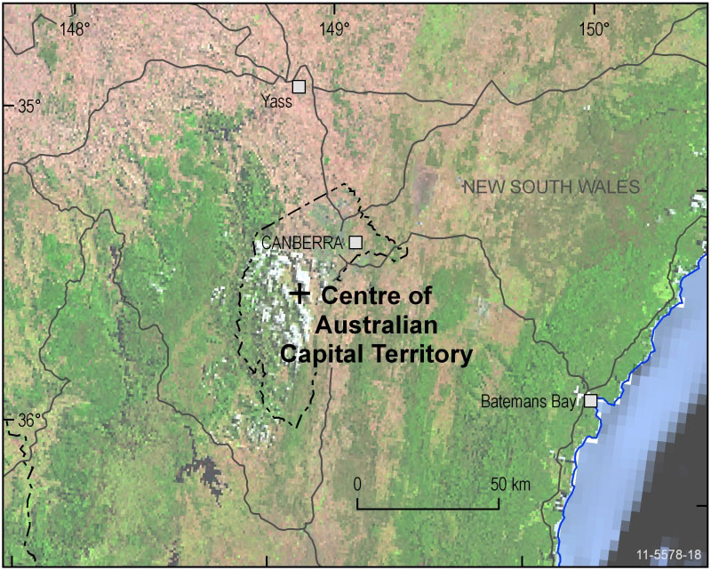
Centre of Australian Capital Territory
The centre of the Australian Capital Territory might be thought of as the former site of the Honeysuckle Creek Tracking Station, approximately 35km south-south-west of Canberra. The tracking station played a leading role in the NASA Apollo missions, closing in 1981 with the end of the Skylab program. The radio telescope was dismantled and relocated to Tidbinbilla in 1983.
Location: 35° 29' 24" South, 149° 00' 05" East
Position on SI55-16 Canberra 1:250 000 and 8726 Michelago 1:100 000 scale maps.
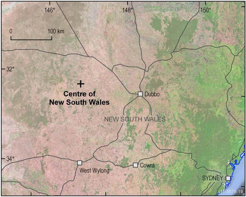
Centre of New South Wales
One possible definition of the centre for New South Wales is located just off Cockies Road, 33km west-north-west of Tottenham (Tottenham is 110km west of Dubbo). This spot, south of the Fiveways Intersection, is marked by a large sign, constructed for Australia's Bicentennial celebrations.
Location: 32° 09' 48" South, 147° 01' 00" East
Position on SI55-03 Narromine 1:250 000 and 8333 Tottenham 1:100 000 scale maps.
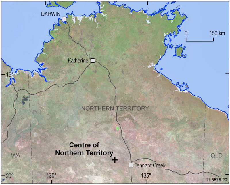
Centre of Northern Territory
Using the method described earlier, one estimate of where the centre of the Northern Territory lies can be found approximately 91 km west-north-west of Tennant Creek. A short distance past the Kartijirarrakanya Claypan, this centre is in a particularly harsh, arid part of the territory.
Location: 19° 23' 00" South, 133° 21' 28" East
Position on SE53-13 Green Swamp Well 1:250 000 and 5559 Lee 1:100 000 scale maps.
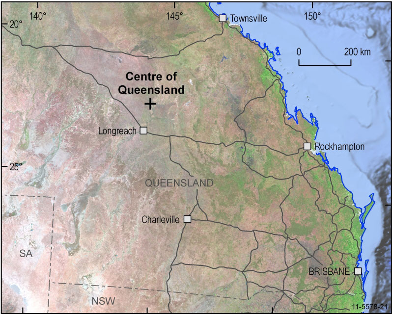
Centre of Queensland
In Queensland, the geographical centre is located 17km north-west of Muttaburra. Also famous from a paleontological perspective, this region was once a pre-historic inland sea. A wealth of fossilized remains has been uncovered here, and when a previously undiscovered species was found, it was became known as the Muttaburrasaurus.
Location: 22° 29' 13" South, 144° 25' 54" East
Position on SF55-09 Muttaburra 1:250 000 and 7753 Culloden 1:100 000 scale maps.
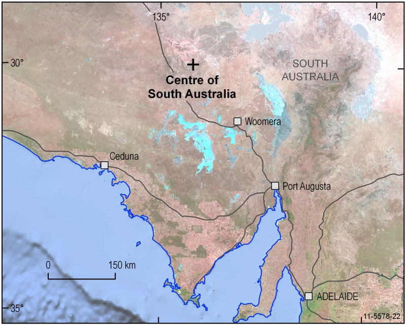
Centre of South Australia
Despite three sides of its border being straight lines, defining the centre of South Australia is no easier thanks to an irregular shaped coastline. According to one method, the centre is near the Churchill Smith bore, which is approximately 12km north-east of the Mt Eba cattle station. In relation to more commonly known landmarks, the centre of South Australia is located some distance south-west of Lake Eyre.
Location: 30° 03' 30" South, 135° 45' 48" East
Position on SH53-11 Kingoonya 1:250 000 and 6037 Eba 1:100 000 scale maps.
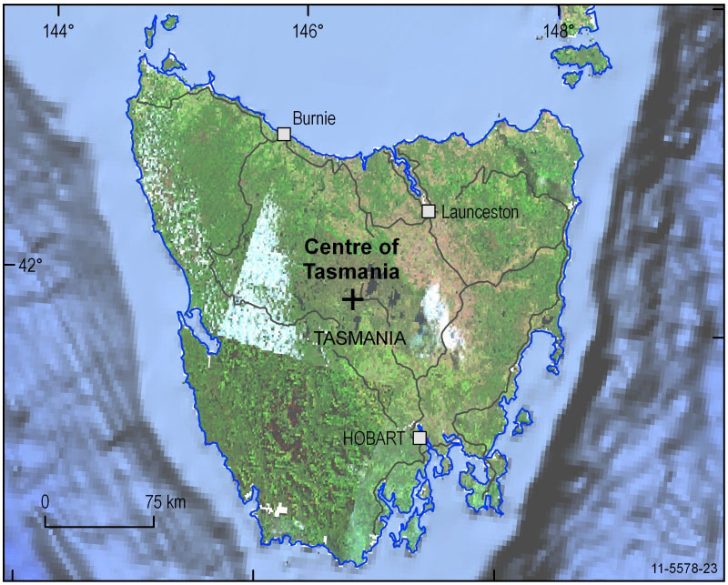
Centre of Tasmania
One possible centre for Tasmania is found on the western shore of Little Pine Lagoon. This small lake lies next to the Marlborough Highway, between the towns of Bronte and Miena. On the Lyell Highway, just a short distance east of Bronte, lies a cairn which was erected in 1983 by members of the Institution of Surveyors (Australian Tasmanian Division). This marker commemorates the early surveyors who explored and mapped the state, and marks Trig Point 715 - said to be near the geographical centre.
Location: 42° 01' 17" South, 146° 35' 36" East
Position on Tasmania South East 1:250 000 and 8214 Meander 1:100 000 scale maps.
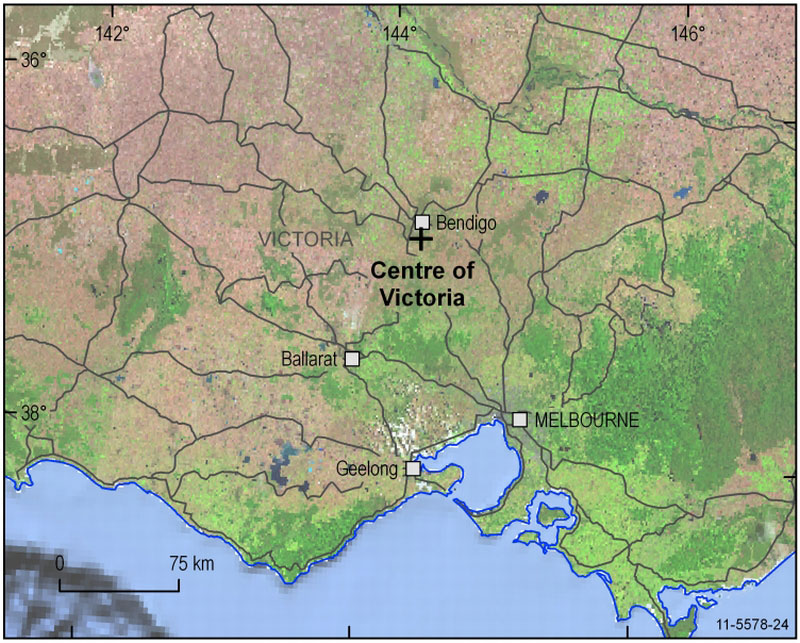
Centre of Victoria
Located around 10km south-south-east of Bendigo, the centre of Victoria might be considered to be on the steps of the Mandurang Uniting Church. No longer in use, the church sits on the site that corresponds with centroid calculations from a number of different organisations, including Geoscience Australia, the Department of Natural Resources and Environment (DNRE), and the Department of Geospatial Science, Royal Melbourne Institute of Technology (RMIT).
Location: 36° 51' 15" South, 144° 16' 52" East
Position on SJ55-01 Bendigo 1:250 000 and 7724 Bendigo 1:100 000 scale maps.
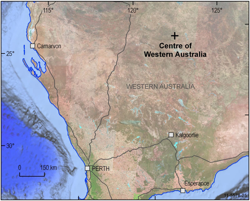
Centre of Western Australia
In Western Australia, what could be called the centre is found in the Gascoyne Region, east south-east of the Glenayle Homestead and north east of the Glenayle - Carnegie Road.
Location: 25° 19' 41" South, 122° 17' 54" East
Position on SG51-06 Stanley 1:250 000 and 3347 Glenayle 1:100 000 scale maps.