Continental Extremities
Page last updated:27 June 2014
Australia is approximately 3860 kilometres long from its most northerly point to its most southerly point in Tasmania, and is almost 4000 kilometres wide, from east to west.
The latitude and longitude of Australia's continental extents
| Extremity | Feature | Latitude | Longitude |
|---|---|---|---|
| North | Cape York (Cape York Peninsula, Queensland) | 10° 41' 21" S | 142° 31' 50" E |
| East | Cape Byron (Byron Bay, New South Wales) | 28° 38' 15" S | 153° 38' 14" E |
| South (Mainland) | South Point (Wilsons Promontory, Victoria) | 39°; 08' 20" S | 146° 22' 26" E |
| South | South East Cape (Tasmania) | 43° 38' 40" S | 146° 49' 30" E |
| West | Steep Point (Shark Bay, Western Australia) | 26° 09' 5" S | 113° 09' 18" E |
Cape York
Located in far-north Queensland, Cape York Peninsula is one of Australia's most distinctive landforms. Its isolation and rugged terrain makes the northern-most point of the Australian mainland a popular destination for 4WD and camping enthusiasts seeking to reach the so called Tip. They are attracted also by the relatively pristine environment and variety of functioning ecosystems ranging from undisturbed coastal regions through to tropical rainforests and dry savannah woodlands.
Overall, Cape York Peninsula, which is bounded by Torres Strait to the north, the Coral Sea to the east and the Gulf of Carpentaria to the west, covers about 137 000 square kilometres.
Cape Byron
Only a few kilometres east of Byron Bay in northern New South Wales, Cape Byron was named by Captain James Cook on May 15, 1770 after John Byron, a fellow navigator and the grandfather of the poet, Lord Byron.
The headland is renowned not only as the continent's most easterly point, but also for its lighthouse and caretakers cottage. The 22 metre high lighthouse, which was built in 1901, is 94 metres above sea level perched on the crest of the Cape Byron headland.
The light is one of the most powerful in the southern hemisphere and is reputed to be visible more than 40 kilometres out to sea.
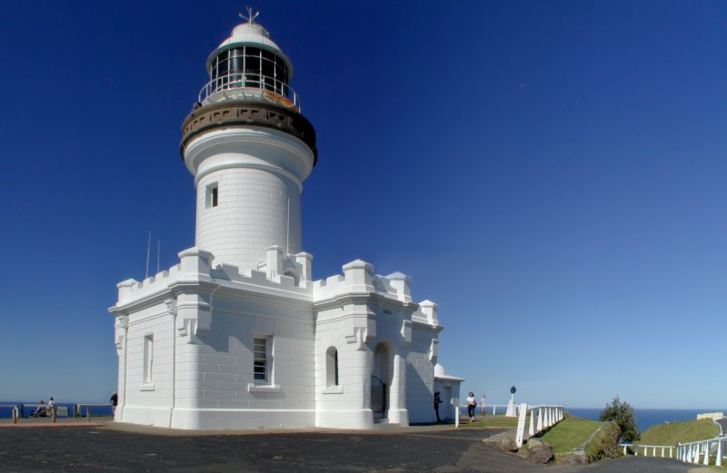
Cape Byron Lighthouse. Credit: Carl Gray
South Point
The most southerly point on the Australian mainland, South Point is located at the tip of Wilsons Promontory National Park near Tidal River in Victoria. South Point is on a peninsula coastline featuring numerous predominant granite headlands. As well as a distinctive coastline, the Prom, as it is affectionately referred to, is dotted with spectacular rock formations, thick forests and fern gullies. As well as the unique vegetation and geology, the 50 000 hectare national park contains the largest coastal wilderness area in Victoria.
South Point is included in the Wilsons Promontory Marine National Park which extends along 70 kilometres of coastline and covers 15 550 hectares, making it the largest Marine National Park in Victoria.
South East Cape
The southern-most point of Australia is South East Cape which is part of Tasmania's isolated southern coastline. The latitudinal distance between South East Cape and Australia's most northerly point at the tip of Cape York is about 3680 kilometres. The area is exposed to all manner of inclement weather extremes with cold, wet, southerly winds prevailing and rain falling every second day on average during summer and more often in other seasons.
As part of Tasmania's remote Southwest National Park and the 1.38 million hectare Tasmanian Wilderness World Heritage Area, South East Cape is accessible only via a walking track from nearby Cockle Creek, which is the most southerly point able to be reached by road in Australia.
Steep Point
Located a short distance from Dirk Hartog Island in Western Australia, Steep Point is part of the western boundary of the Shark Bay World Heritage Area. A feature of the area is the Zuytdorp Cliffs, which make up the longest fault scarp in Australia and are among the continents highest.
The sheer cliffs, tower up to 200m above sea level and stretch more than 200km from Kalbarri to the Shark Bay, interrupted only by a number of small bays, such as False Entrance and Crayfish Bay.
They were named after the Dutch ship, Zuytdorp, which was wrecked on the rugged coast in 1712 and remains on the seabed near the cliffs. Steep Point was named first in 1697 by Willem de Vlamingh who called it 'Steyle Hock' (Translation: Steep Point) and was similarly called Point Escarpee by Louis Claude de Freycinet in 1801 before being Anglicised as Steep Point by Phillip Parker King in 1822.