Islands
Page last updated:1 November 2023
Being surrounded by ocean, Australia is often referred to as an island continent. As a continental landmass, Australia is significantly larger than its fringing islands. These range in size from small rocks which are not covered by water at high tide, to islands which are more than twice the size of the Australian Capital Territory. Among Australia’s islands is the world's largest sand island, K'gari.
Australia has a number of large islands in the Pacific, Indian and Southern Oceans and the Coral and Timor Seas which form Australia’s External Territories. There are also several islands closer to the Australian mainland which are larger than 1000 square kilometres.
Largest islands
| State/Territory | Name | Area (km2) |
|---|---|---|
| Northern Territory | Melville | 5786 |
| South Australia | Kangaroo | 4416 |
| Northern Territory | Groote Eylandt | 2285 |
| Northern Territory | Bathurst | 1693 |
| Queensland | K'gari | 1653 |
| Tasmania | Flinders | 1359 |
| Tasmania | King | 1091 |
| Queensland | Mornington | 1002 |
Calculations on Australia's coastline lengths are taken from Geoscience Australia's GEODATA Coast 100K 2004 database. The data is nationally uniform, is sourced primarily from the 1:100 000 scale National Topographic Map Series and is the most authoritative data currently available on the length of Australia's island coastlines.
Number of islands
| State/Territory | Number of Islands |
|---|---|
| Western Australia | 3747 |
| Queensland | 1955 |
| Tasmania | 1000 |
| Northern Territory | 887 |
| South Australia | 346 |
| Victoria | 184 |
| New South Wales | 102 |
| Jervis Bay Territory | 1 |
| Australian Capital Territory | - |
| TOTAL | 8222 |
K'gari
Located just off the coast of southern Queensland, K'gari is the largest sand island in the world (165 280 ha), stretching over 123 kilometres in length and reaching 25 kilometres at its widest point. The island displays vastly different landscapes, ranging from freshwater lakes to sand dunes and wetlands to crystal clear lakes and dense rainforests.
K'gari is famous also for its coloured sands. These sands have been stained by decayed vegetation leaching into the sand for thousands of years, with some desposits up to eight million years old. On the eastern beach there is an excellent example of this process called The Cathedrals. In the 1970s, there were major battles fought against the prospect of sand-mining on K'gari. The result was an Australian Government ban on this type of mining on the island. Today, K'gari has a World Heritage listing and the Great Sandy National Park which covers 52 400 hectares on the northern half of the island.

Indian Head, one of the volcanic rock protrusions on the island which is otherwise dominated by sand. © webshots.
Macquarie Island
In contrast to K'gari, Macquarie Island is one of Australia's most distant possessions. Located in the Southern Ocean at a latitude of 54°30' South, longitude 158°57' East, Macquarie Island is actually 200 kilometres closer to the Antarctic continent than its parent state of Tasmania which lies 1500 kilometres north-west of the island. Covering 128 square kilometers, Macquarie Island is 34 kilometers long but is just five kilometers at its widest point.
In 1996, Macquarie Island was nominated by the Australian Government for inscription on the World Heritage Register, mainly for its unique geological features. The island is the exposed crest of the undersea Macquarie Ridge, raised to its present position where the Indo-Australian tectonic plate meets the Pacific plate.
It is the only place on Earth where rocks from the Earth's mantle are exposed above sea level. These unique exposures include excellent examples of pillow basalts and other extrusive rocks. For more than 50 years, Australia has operated a research and Antarctic support station at the northern end of the island. The station was built in 1948 and is home to more than 40 people during the summer and around 20 through winter.
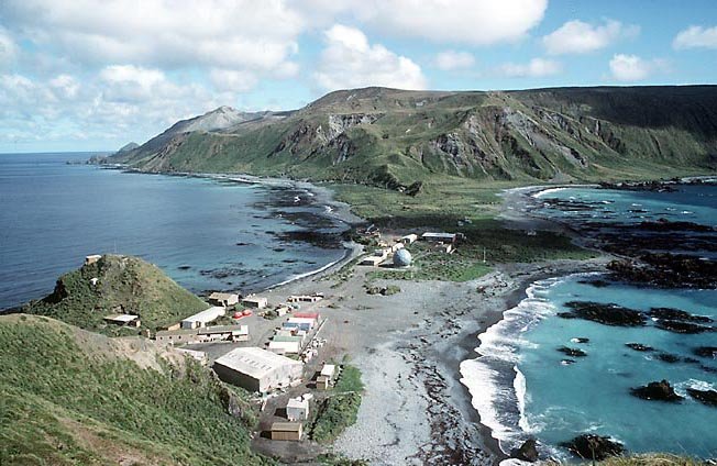
Macquarie Island Research Station, on a narrow section of lowland. Credit: Australian Antarctic Division.