Significant Rock Features
Page last updated:27 June 2014
Australia has some of the oldest geological features in the world with the oldest known rocks dating from more than 3000 million years ago and rare zircon crystals dating back 4400 million years located in much younger rocks. The zircons evolved very soon after the planet was formed. These ancient features compare with the oldest known rock on Earth in northwestern Canada. Scientists say that rock was formed 4031 million years ago.
Some areas of Victoria and Queensland are geologically much younger as a result of volcanic activity which last erupted a few thousand years ago. Australia's youngest mainland volcano is Mount Gambier in South Australia which last erupted only about 6000 years ago.
In recent years, the advent of improved technology and more extensive geological exploration has resulted in a greater knowledge of the age of rocks in Australia. It has resulted also in an increased ability to better understand the continent's past. This has been achieved by combining exploration methods such as deep seismic surveys with geochronology methods, including use of equipment such as the Sensitive High-Resolution Ion Microprobe, or SHRIMP. This equipment uses uranium and lead isotopes from tiny portions of zircon crystals which have been extracted from rock samples to calculate the age of the crystal based on the natural decay rate of uranium to lead. The SHRIMP is central to Geoscience Australia's geochronology program.
Uluru - Northern Territory
Formerly named Ayers Rock, this massive sandstone rock covers an area of 3.3 square kilometres, and is 9.4 kilometres around its base. It rises 345 metres above the plains, and is the surface expression of a much larger volume of rock. An eroded remnant, Uluru was laid down in an inland sea during the Cambrian Period about 500 million years ago.
Earth uplifting and folding about 300 - 400 million years ago tipped the rock to create the present vertical orientation from the original horizontal sedimentary strata.
Erosion of the surrounding area then left Uluru and nearby Kata Tjuta exposed. Both are within the Uluru-Kata Tjuta National Park.
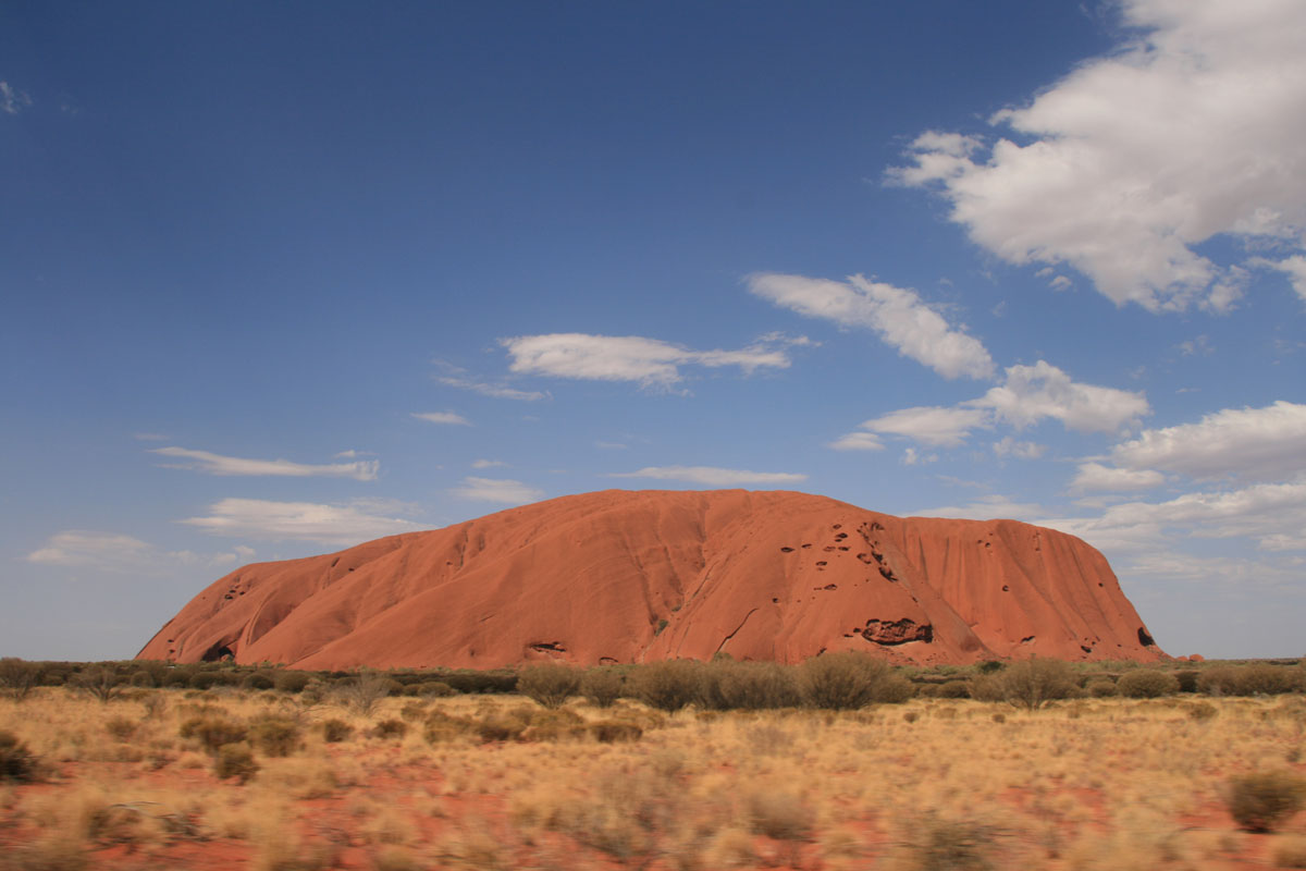
Uluru in Central Australia's outback Northern Territory.
Kata Tjuta - Northern Territory
Formally known as the Olgas, Kata Tjuta is made up of 28 rounded domes with the tallest, Mt. Olga at 545.4 m above the surrounding plain, making it almost 200 metres higher than nearby Uluru. The domes are made of the sedimentary rock conglomerate with iron oxide impurities.
The conglomerate resulted from erosion of mountains pushed up during Cambrian earth movements, and consists of sandstone, granite and ironstone bound together by muddy and sandy sediments. Both features are within the Uluru-Kata Tjuta National Park.
The name Kata Tjuta means 'many heads' in traditional Aboriginal language.
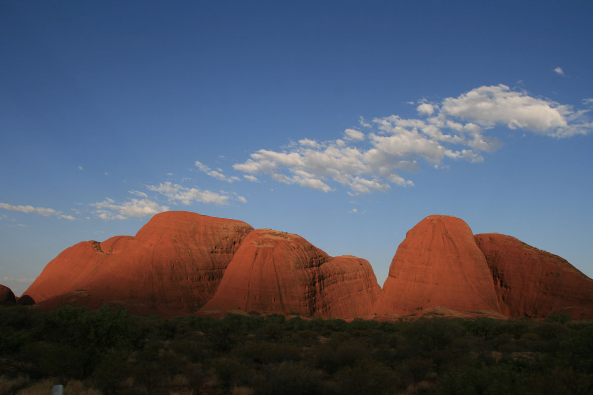
Kata Tjuta-Olgas.
Karlwe Karlwe - Northern Territory
Karlwe Karlwe, or the Devil's Marbles, near Wauchope in the Northern Territory are a collection of large rounded granite boulders, many of which are precariously balanced on top of another. The granite here formed from molten rock which solidified beneath a layer of sandstone and developed vertical and horizontal fractures. Over time, the sandstone eroded away exposing the granite, which then weathered into soft sand and clay surrounding hard bits of granite called corestones. Gradual removal of the soft sand and clay has exposed the rounded boulders, allowing them to be perched on top of one other. According to Aboriginal dreaming, the rocks are sacred and are the fossilised eggs of the Rainbow Serpent.

Karlwe Karlwe
Mount Augustus - Western Australia
The visible portion of the sandstone and conglomerate structure which makes up Mount Augustus, is twice the size of Uluru. Sitting on a bedrock of granite, the mountain is eight kilometres long and stands 858 metres above the surrounding plain and 1105 metres above sea level. Sometimes described as the world's largest monocline, it is estimated that the rock of the mountain is around 1000 million years old and was formed from an uplift which raised an ancient seabed of sedimentary proterozoic sandstone and conglomerate. The granite rock which lies beneath Mount Augustus is said to be 1650 million years old. The Indigenous name for Mount Augustus is Burringurah.
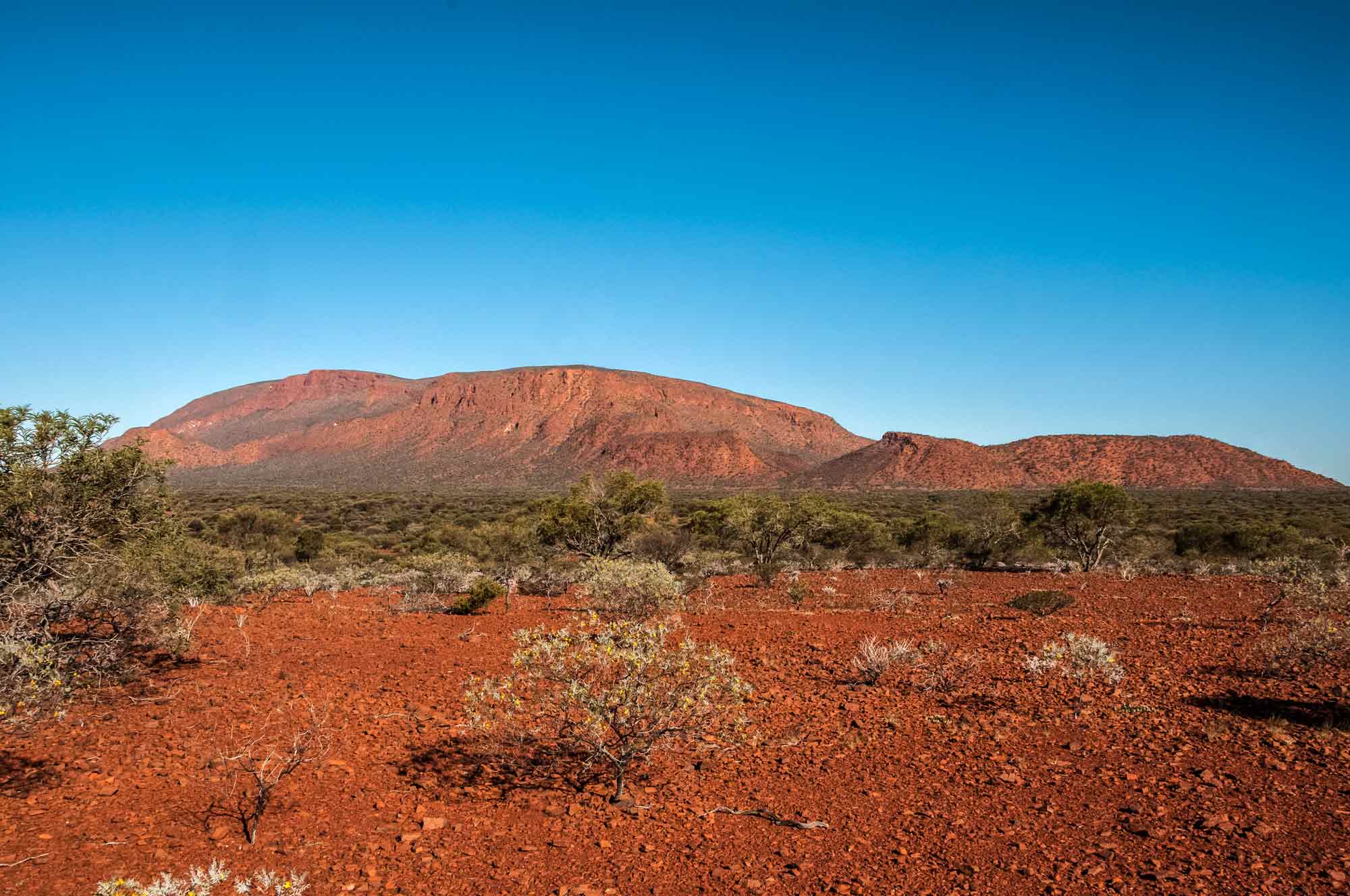
Mount Augustus, Western Australia. Credit: Graeme Churchard, Wikimedia Commons.
Wave Rock - Western Australia
Formed more than 2700 million years ago, Wave Rock is 14 metres high, and 110 metres long. The granite cliff resembling a wave about to break is on the northern face of a large erosional remnant called Hyden Rock. This curved cliff face has been rounded by weathering and water erosion, undercutting its base and leaving a rounded overhang. It was formed by water dissolving and re-depositing chemicals in the granite as it runs down the cliff face.
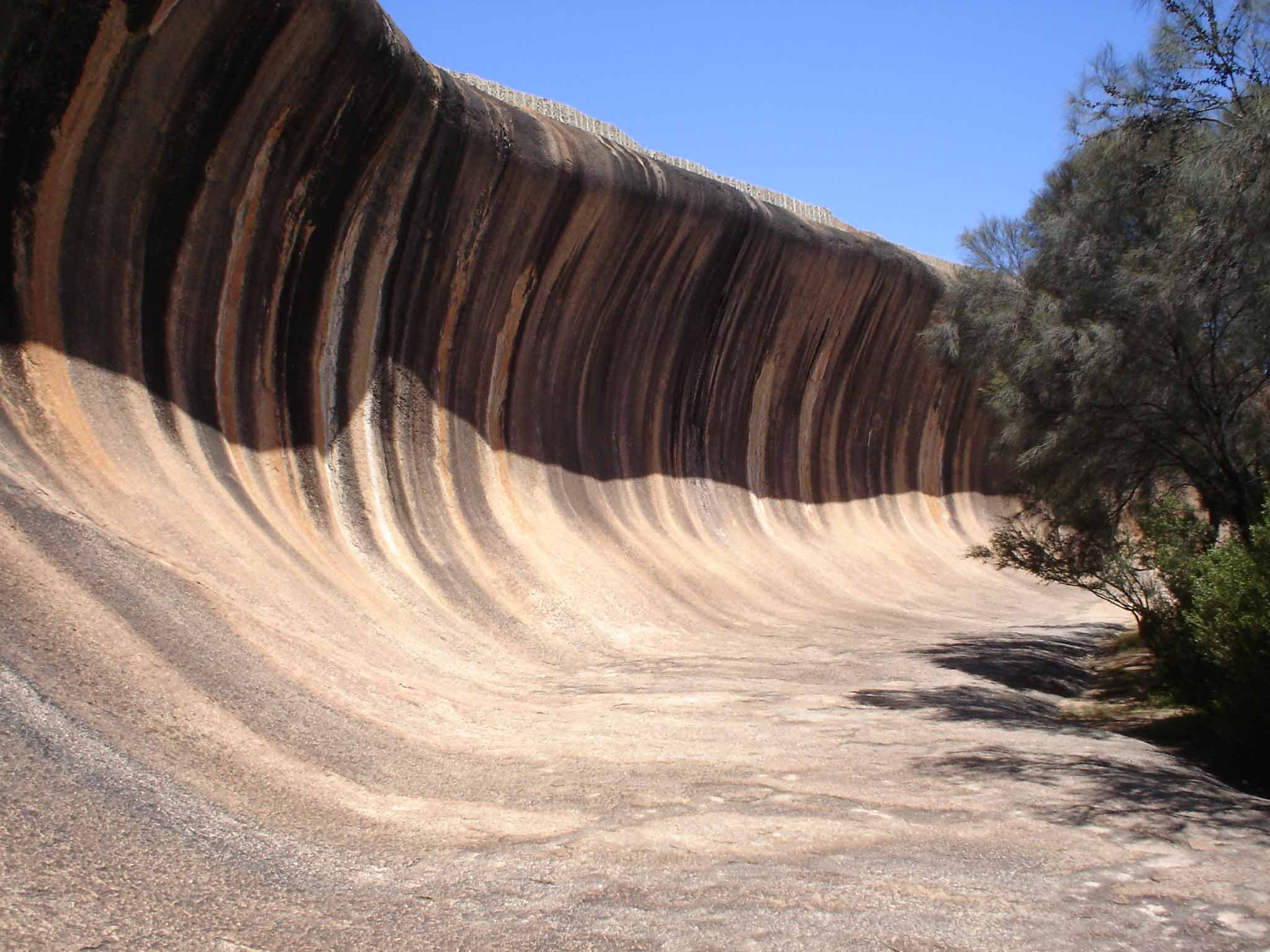
Wave Rock, near Hyden, Western Australia. Credit: Fredrik Bülow, Wikimedia Commons.
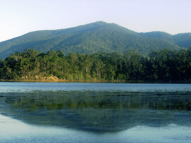
Gulaga (Mt Dromedary) - New South Wales
The mountain is an isolated volcanic core rising 797 metres above sea level near the historical villages of Tilba Tilba and Central Tilba. Viewed from the sea the mountain resembles a dromedary camel. It was formed during volcanic activity which took place about 100 million years ago.
Mt Dromedary (Gulaga) near Tilba Tilba NSW. Credit: Renal Ride.
Bald Rock - New South Wales/Queensland border
An inselberg, or isolated rock hill, Bald Rock is said to be Australia's largest exposed granite surface. It towers about 200 metres above the surrounding bushland, is 750 metres long, 500 metres wide and rises to 1277 metres above sea level. The granite which forms Bald Rock was emplaced into the surrounding metamorphic and sedimentary rock about 247 million years ago. Subsequent uplift and erosion has removed the majority of the surrounding sediments and metamorphic rocks, with Bald Rock remaining as a result of its resistance to weathering.
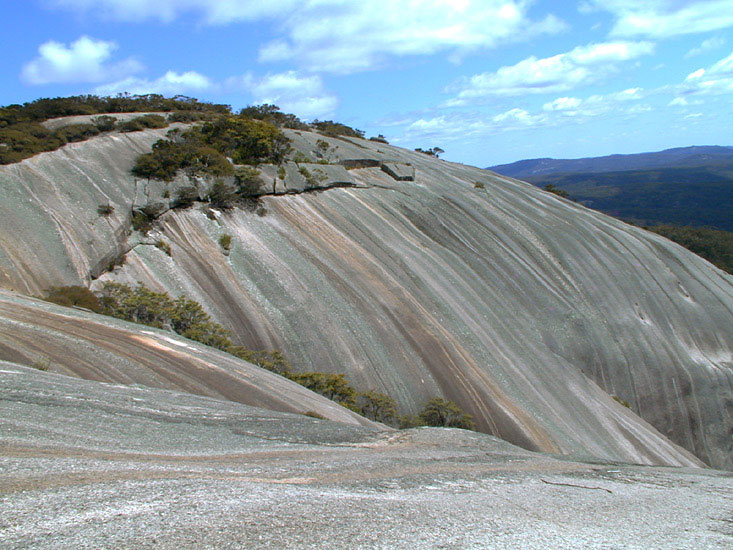
Bald Rock on the New South Wales/Queensland border
Oldest known rocks in each State and Territory
| State/Territory | Rock Unit and Location | Rock Type | Age (millions of years) | Geological Time (Era) | Reference |
|---|---|---|---|---|---|
| Western Australia | Meeberrie Gneiss, Murchison District | Gneiss | 3731 ± 4 | Eoarchean | Nutman A.P., Bennett V.C., Kinny P.D. and Price R. 1993. Large-scale crustal structure of the Northwestern Yilgarn craton, Western Australia: evidence from Nd isotopic data and zircon geochronology. Tectonics, 12:971-981. |
| South Australia | Cooyerdoo Granite, Eyre Peninsula | Granite | 3157 ± 2 | Mesoarchean | Fraser, G. L., McAvaney, S., Neumann, N. L., Szpunar, M. & Reid, A. Discovery of Early Mesoarchean crust in the eastern Gawler Craton, South Australia. Submitted to Precambrian Research. |
| Northern Territory | Kukalak Gneiss, West Arnhem Land | Gneiss | 2671 ± 3 | Neoarchean | Hollis, J.A., Carson, C.J. and Glass, L.M. (in press). SHRIMP U-Pb zircon geochronological evidence for Neoarchean basement in western Arnhem Land, northern Australia (in press). |
| Queensland | Yaringa Metamorphics, Mount Isa | Orthogneiss | 1874 ± 4 | Paleoproterzoic | Bierlein F.P., Black L.P., Hergt J. and Mark G. 2008. Evolution of Pre-1.8 Ga basement rocks in the western Mt Isa Inlier, northeastern Australia-Insights from SHRIMP U-Pb dating and in-situ Lu-Hf analysis of zircons. Precambrian Research 163:159-173. |
| New South Wales | Redan Gneiss, Broken Hill | Gneiss | 1710 ± 4 | Paleoproterzoic | Stevens, B. P. J., Page, R. W. and Crooks, A. (2008) 'Geochronology of Willyama Supergroup metavolcanics, metasediments and contemporaneous intrusions, Broken. |
| Tasmania | Surprise Bay Formation, King Island | Metasedimentary | ~1300 | Mesoproterozoic | Calver C.R. (2007) Some notes on the geology of King Island. Tasmanian Geological Survey Record 2007/02. |
| Victoria | Nothing formally defined with absolute radiometric ages; likely to be rare outcrops. | Unknown | ~600 | Believed to be Neoproterozoic | Cayley R.A., Taylor D.H., A. H. M. VandenBerg A.H.M. and Moore D.H. (2002). Proterozoic - Early Palaeozoic rocks and the Tyennan Orogeny in central Victoria: the Selwyn Block and its tectonic implications. Australian Journal of Earth Sciences 49:225-254. |
| Australian Capital Territory | Adaminaby Beds, Brindabella Ranges | Sedimentary | ~470 | Ordovician | Finalyson D.M. (Ed.) 2008. A geological guide to Canberra Region and the Namadgi National Park. Geological Society of Australia (ACT Division), 140 p. |
This list contains the oldest known rocks from each State and Territory at October 2009. In some cases the ages are yet to be determined accurately and is limited by the nature of the rock and analytical techniques. There is always the chance that older rocks will be found.