Australian Height Datum
Page last updated:14 December 2017
The Australian Height Datum (AHD) is the official national vertical datum for Australia and refers to Australian Height Datum 1971 (AHD71; Australian mainland) and Australian Height Datum (Tasmania) 1983 (AHD-TAS83). Before AHD, there were many local height datums used by the states and territories.
AHD was adopted by the National Mapping Council in May 1971 as the datum to which all vertical control for mapping was to be referred. The datum surface passes through approximate mean sea level (MSL) realised between 1966 and 1968 at tide gauges around the coastline (Figure 1).
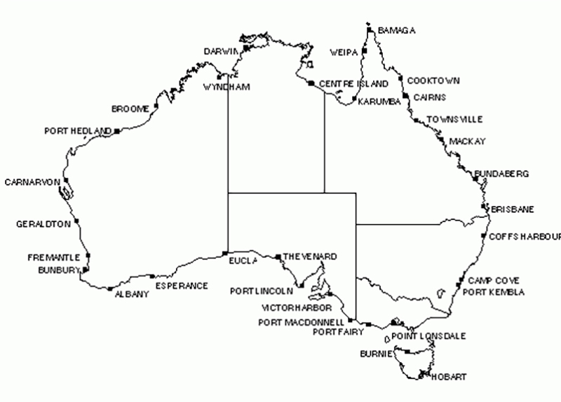
Figure 1: The locations of the tide gauges used to define AHD
AHD heights were derived across Australia through a least squares adjustment of 97,320 km of 'primary' levelling (used in the original adjustment) and 80,000 km of 'supplementary' levelling (applied in a subsequent adjustment). Levelling observations ran between junction points in the network and were known as level sections. These level sections were created by combining levelling observations along level runs (usually following major roads). The interconnected network of level sections and junction points was constrained at the 30 tide gauge sites, which were assigned a value of zero AHD. The least squares adjustment propagated mean sea level heights, or AHD, across the level network. Despite the best efforts of surveyors, systematic, gross and random errors crept into the level sections and were distributed across the network within the least squares adjustment.
The Australian Height Datum (Tasmania) 1983 (AHD-TAS83) is based on mean sea level in 1972 at tides gauges in Hobart and Burnie. It was propagated throughout Tasmania using third order differential levelling over 72 sections between 57 junction points and computed via adjustment on 17 October 1983. Mean sea level at both Hobart and Burnie was assigned the value of zero.