NTDB & NTMS Specifications (250K & 100K)
|
Updated: 1 December 2007
2.1 Habitation and Associated Areas
2.1.1 Homesteads
2.1.1.1 Example 1
| |
| Location of Example: |
151°17'24" East, 27°39'27" South |
| Distinctive Characteristics: |
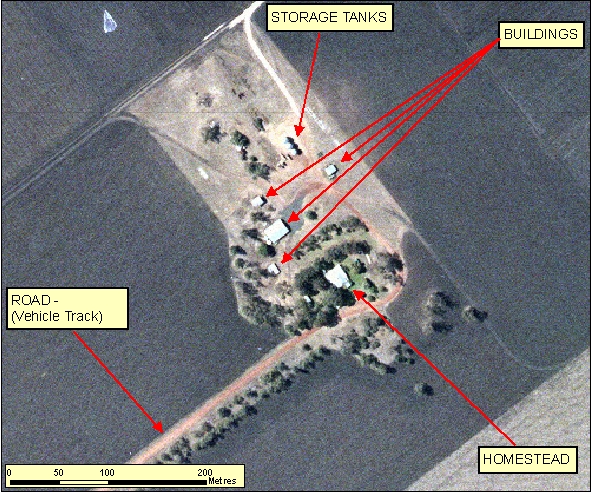
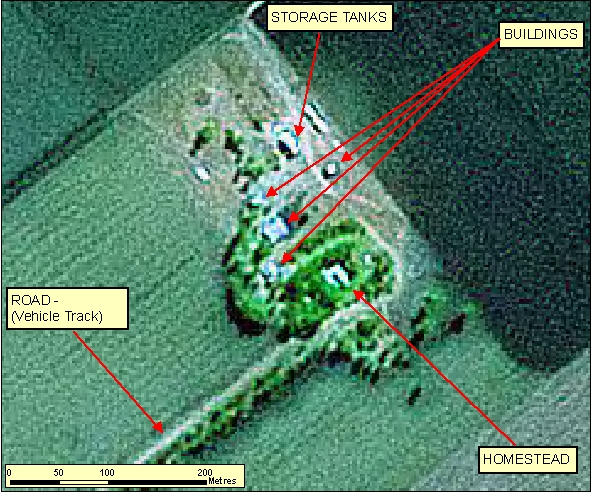
- Homesteads are characteristically surrounded by irrigated vegetation/gardens.
- In Figure 2.1.1.1a the Buildings appear as rectangular elevated features, this is evident by shadow signatures. The Storage Tanks have a more linear narrow appearance but still exhibit the elevated shadow signatures.
- In many cases the main access road to the Homestead may be lined with vegetation.
|
| Regional Considerations: |
|
| Figure: 2.1.1.1 Representation of a Homestead in association with surrounding features. |
[back to top]
2.1.1.2 Example 2
| |
| Location of Example: |
151°17'33" East, 27°37'55" South |
| Distinctive Characteristics: |
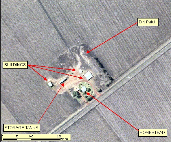
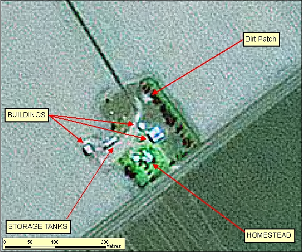
- In Figure 2.1.1.2a the Buildings appear as rectangular elevated features, this is evident by shadow signatures. The Storage Tanks have a more linear narrow appearance but still exhibit the elevated shadow signatures.
- In many cases the main access road to the Homestead may be lined with vegetation.
- The cleared/dirt patch does not exhibit any shadow signature and should not be captured mistakenly as a Building.
|
| Regional Considerations: |
|
| Figure: 2.1.1.2 Representation of a Homestead in association with surrounding features. |
[back to top]
2.1.2 Buildings
2.1.2.1 Example 1
| |
| Location of Example: |
152°45'35" East, 25°16'23" South |
| Distinctive Characteristics: |
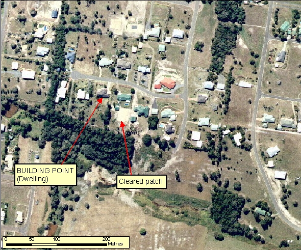
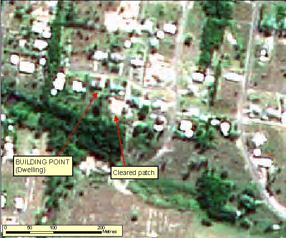
- Buildings can be distinguished by their right angled construction and shadow.
- Cleared/dirt patches do not exhibit any shadow signature and should not be captured mistakenly as a Building.
|
| Regional Considerations: |
|
| Figure: 2.1.2.1 Representation of Buildings in association with surrounding features. |
[back to top]
2.1.2.2 Example 2
| |
| Location of Example: |
152°40'01" East, 25°27'38" South |
| Distinctive Characteristics: |
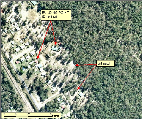
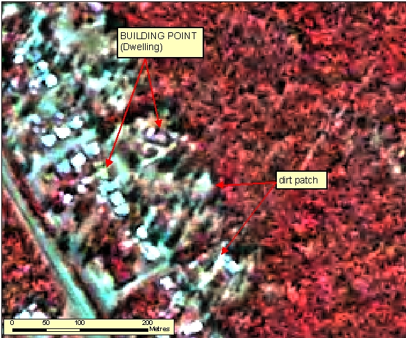
- Buildings can be distinguished by their right angled construction and shadow.
- Cleared/dirt patches do not exhibit any shadow signature and should not be captured mistakenly as a Building.
|
| Regional Considerations: |
|
| Figure: 2.1.2.2 Representation of Buildings in association with surrounding features. |
[back to top]
2.1.3 Schools
2.1.3.1 Example 1
| |
| Location of Example: |
152°50'43" East, 25°17'16" South |
| Distinctive Characteristics: |
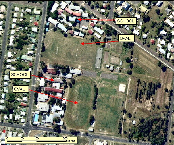
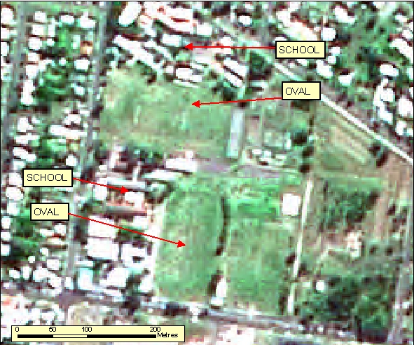
- School complexes within Built Up Areas are normally associated with playing fields. This combination of grouped Buildings and sporting fields distinguishes them from other complexes.
|
| Regional Considerations: |
|
| Figure: 2.1.3.1 Representation of a School in association with surrounding features. |
[back to top]
2.1.3.2 Example 2
| |
| Location of Example: |
152°52'23" East, 25°18'22" South |
| Distinctive Characteristics: |
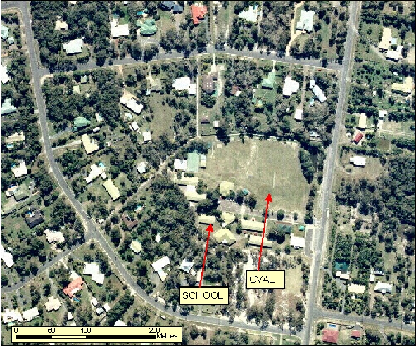
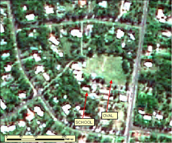
- School complexes within Built Up Areas are normally associated with playing fields. This combination of grouped Buildings and sporting fields distinguishes them from other complexes.
|
| Regional Considerations: |
|
| Figure: 2.1.3.2 Representation of a School in association with surrounding features. |
[back to top]
2.1.3.3 Example 3
| |
| Location of Example: |
151°26'41" East, 27°34'49" South |
| Distinctive Characteristics: |
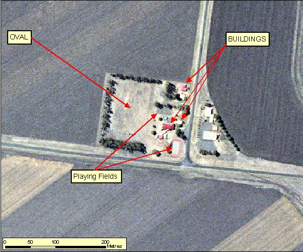
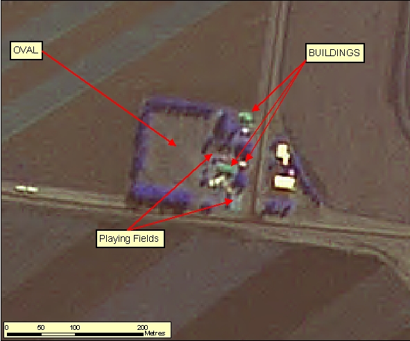
- Generally rural school complexes are significantly smaller than their typical urban schools counterparts.
- The school's associated infrastructure, such as ovals and playing fields, can still be identified.
|
| Regional Considerations: |
|
| Figure: 2.1.3.3 Representation of a School in association with surrounding features. |
[back to top]
2.1.4 Hospitals
2.1.4.1 Example 1
| |
| Location of Example: |
152°49'33" East, 25°17'54" South |
| Distinctive Characteristics: |
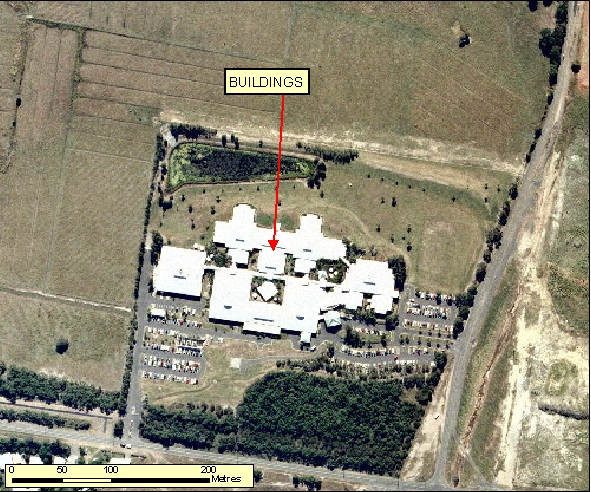
- Hospitals normally have interlinking Buildings, large carparks and may have an associated Helipad on either the grounds or on the roof.
- Normally these are well defined in Reference Material.
|
| Regional Considerations: |
|
| Figure: 2.1.4.1 Representation of a Hospital in association with surrounding features. |
[back to top]
2.1.5 Golf Courses
2.1.5.1 Example 1
| |
| Location of Example: |
152°49'16" East, 25°16'45" South |
| Distinctive Characteristics: |
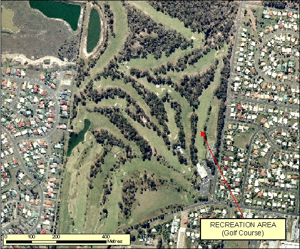
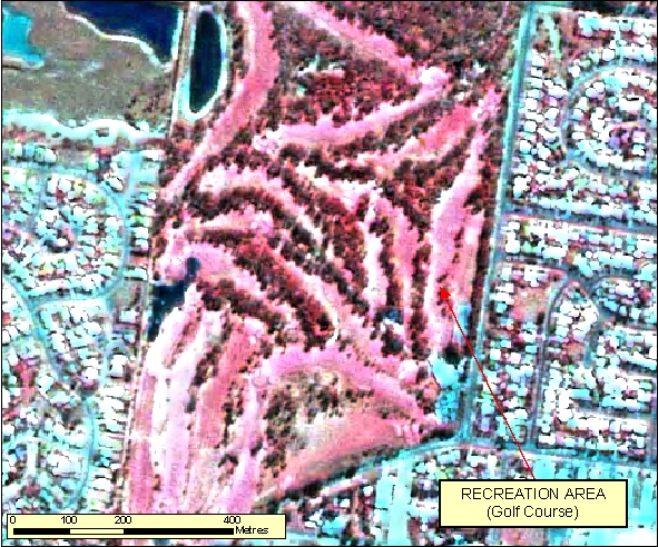
- Golf courses have very characteristic fairways that are close together and generally lined with trees.
- There are often water bodies associated with the course and numerous small sand traps mostly at the ends of the fairways.
- Golf Courses often have a definite boundary and are within or adjacent to residential areas.
- In Figure: 2.1.5.1b note the light red signature of the grass fairways and the dark red signature of the aligning trees. Also note the contrast of the surrounding residential area represented as bright blue. The sand traps show up as white and the water bodies shows up as a deep blue.
|
| Regional Considerations: |
|
| Figure: 2.1.5.1 Representation of a Golf Course. |
[back to top]
2.1.6 Greenhouses
2.1.6.1 Example 1
| |
| Location of Example: |
152°25'53" East, 24°57'25" South |
| Distinctive Characteristics: |
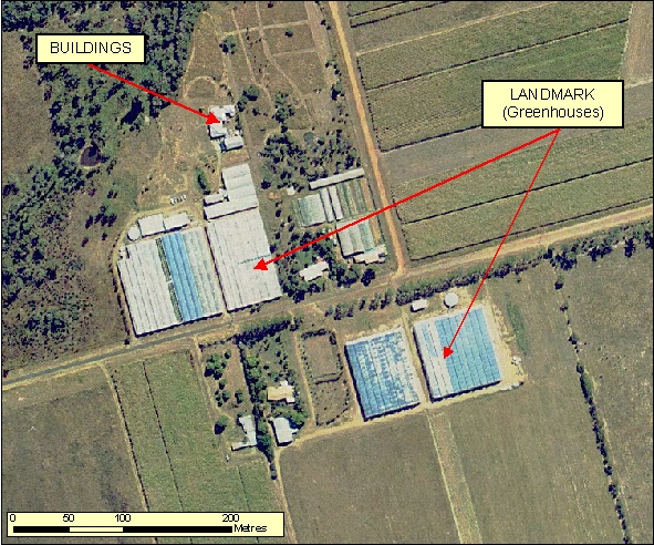
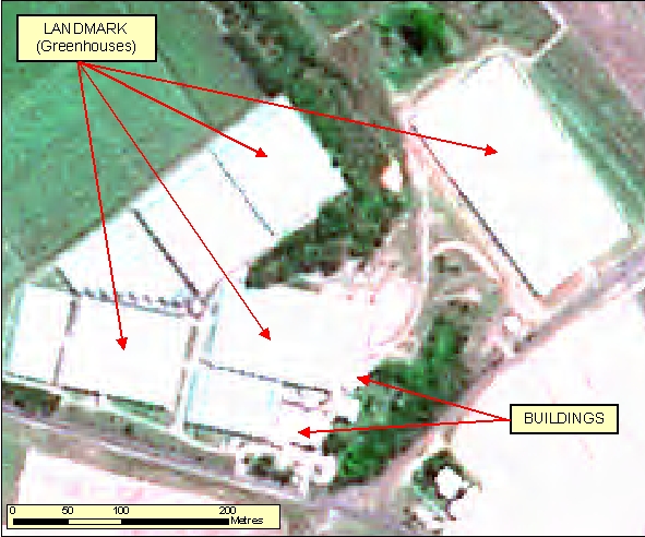
- Greenhouses are generally located near farm infrastructure and Homesteads.
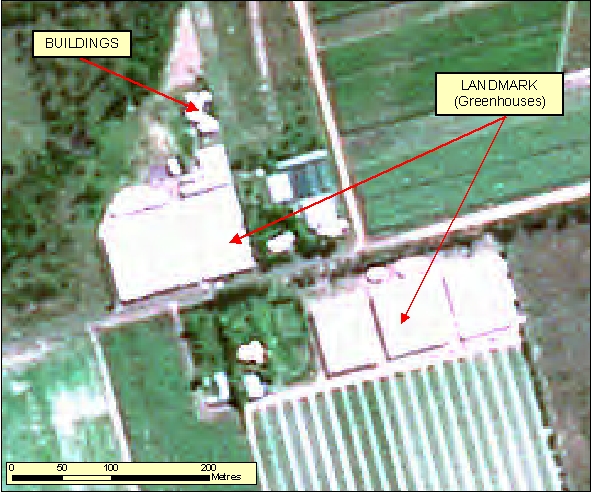
- Greenhouses tend to have uniquely reflective surfaces, and often appear as a raised square or rectangular structures, evident by their shadow.
- They are distinguishable by their segmented, grid like roof pattern.
- In Figure: 2.1.6.1b the segmentations of the rooves of the greenhouses are not clear and therefore can easily be confused with large sheds or Buildings.
|
| Regional Considerations: |
|
| Figure: 2.1.6.1 Representation of Greenhouses in association with surrounding features. |
[back to top]
2.1.6.2 Example 2
| |
| Location of Example: |
152°15'10" East, 24°44'5" South |
| Distinctive Characteristics: |
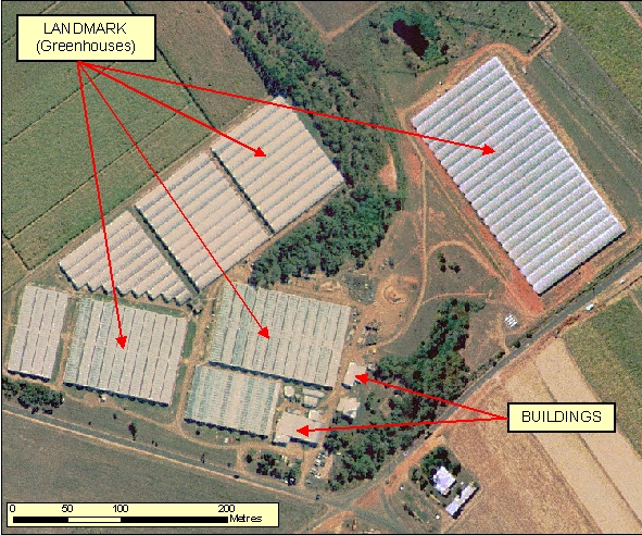
- Greenhouses are generally located near farm infrastructure and Homesteads.
- Greenhouses tend to have uniquely reflective surfaces, and often appear as a raised square or rectangular structures, evident by their shadow.
- They are distinguishable by their segmented, grid like roof pattern.
- In Figure: 2.1.6.2b the segmentations of the rooves of the greenhouses are not clear and therefore can easily be confused with large sheds or Buildings.
|
| Regional Considerations: |
|
| Figure: 2.1.6.2 Representation of Greenhouses in association with surrounding features. |
[back to top]
2.1.7 Rifle Ranges
2.1.7.1 Example 1
| |
| Location of Example: |
152°41'00" East, 25°30'38" South |
| Distinctive Characteristics: |
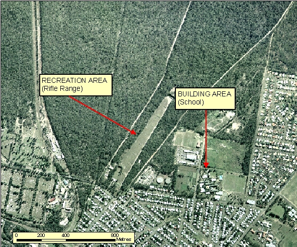
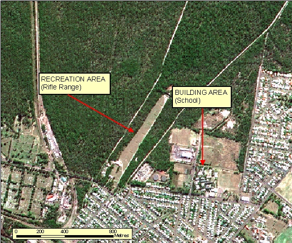
- In Figure: 2.1.7.1 the rectangular cleared strip indicates a Rifle Range. The markers are contained along the length of the range to indicate the distance for the shoot. There is also generally a club house associated with the Rifle Range
|
| Regional Considerations: |
|
| Figure: 2.1.7.1 Representation of a Rifle Range in association with surrounding features. |
[back to top]
2.1.8 Race Courses
2.1.8.1 Example 1
| |
| Location of Example: |
151°54'58" East, 27°55'30" South |
| Distinctive Characteristics: |
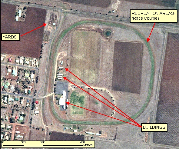
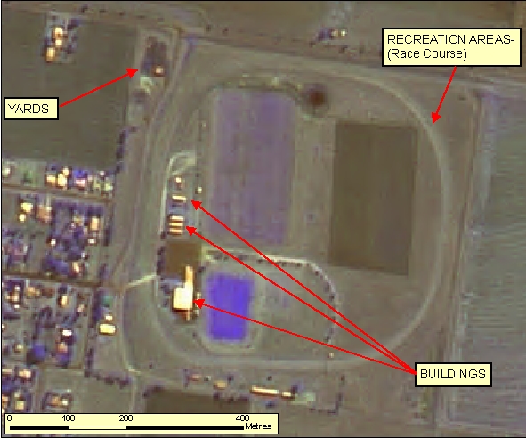
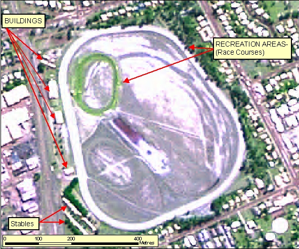
- Race Courses generally have a distinctive circular signature as well as associated infrastructure; Buildings and Yards.
- Race Courses normally have an associated smaller internal or adjacent track for horse training purposes.
- The Orthophotography shows how the Race Course track has been irrigated causing a contrast in relation to the surrounding dry ground.
|
| Regional Considerations: |
- Race Courses are typically found on the outer edge of Built Up Areas.
|
| Figure: 2.1.8.1 Representation of a Race Course in association with surrounding features. |
[back to top]
2.1.8.2 Example 2
| |
| Location of Example: |
152°16'46" East, 27°51'44" South |
| Distinctive Characteristics: |
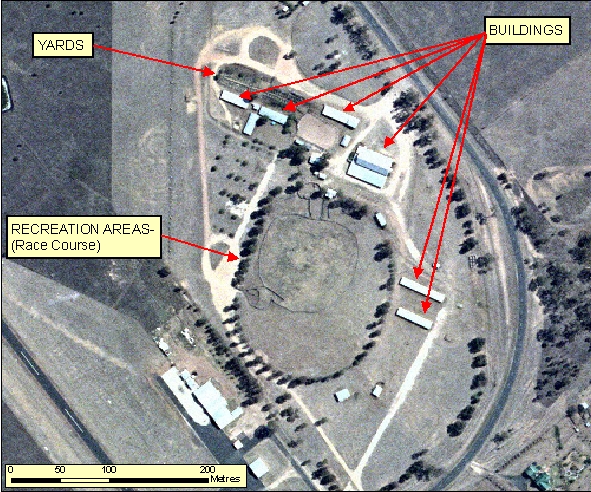
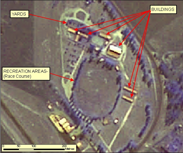
- Race Courses generally have a distinctive circular signature as well as associated infrastructure; Buildings and Yards.
- Race Courses normally have an associated smaller internal or adjacent track for horse training purposes.
- The Orthophotography shows how the Race Course track has been irrigated causing a contrast in relation to the surrounding dry ground.
|
| Regional Considerations: |
- Race Courses are typically found on the outer edge of Built Up Areas.
|
| Figure: 2.1.8.2 Representation of a Race Course in association with surrounding features. |
[back to top]
2.1.8.3 Example 3
| |
| Location of Example: |
152°21'17" East, 24°53'23" South |
| Distinctive Characteristics: |
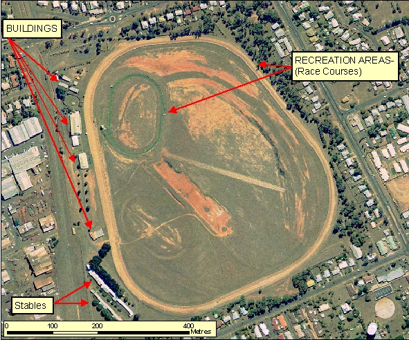
- Race Courses generally have a distinctive circular signature as well as associated infrastructure; Buildings and Yards.
- Race Courses normally have an associated smaller internal or adjacent track for horse training purposes.
- The Orthophotography shows how the Race Course track has been irrigated causing a contrast in relation to the surrounding dry ground.
|
| Regional Considerations: |
- Race Courses are typically found on the outer edge of Built Up Areas.
|
| Figure: 2.1.8.3 Representation of a Race Course in association with surrounding features. |
[back to top]
2.1.9 Cemeteries
2.1.9.1 Example 1
| |
| Location of Example: |
152°40'22" East, 25°30'52" South |
| Distinctive Characteristics: |
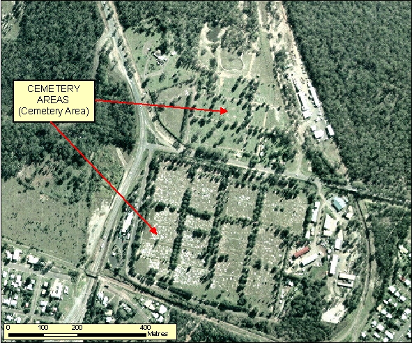
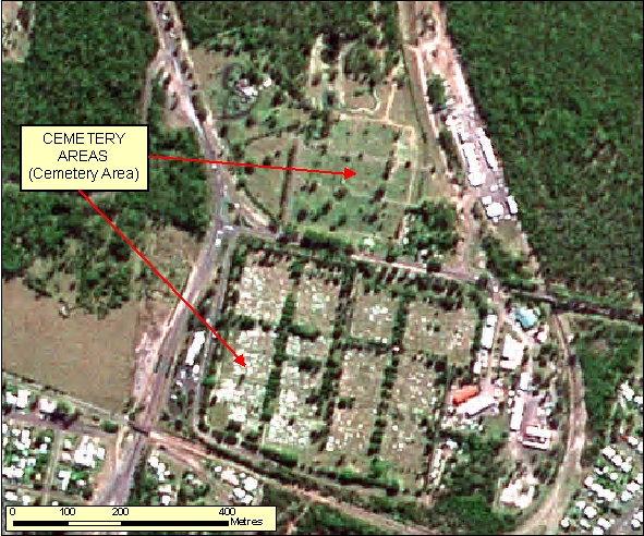
- Medium to large sized cemeteries are often within or on the outskirts of Population Centres.
- In Figure: 2.1.9.1 the white headstones are clearly visible in the southern part of the Cemetery.
|
| Regional Considerations: |
|
| Figure: 2.1.9.1 Representation of a Cemetery in association with surrounding features. |
[back to top]
2.1.10 Substations
2.1.10.1 Example 1
| |
| Location of Example: |
152°22'09" East, 24°54'29" South |
| Distinctive Characteristics: |
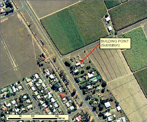
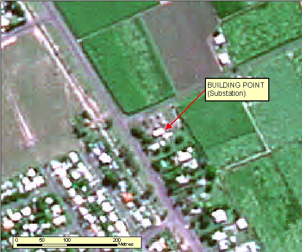
- As shown in Figure: 2.1.10.1a the complex depicting the Substation layout can be normally seen on ortho-photography, however only capture the Building associated with this feature.
- As shown in Figure: 2.1.10.1b Substations are difficult to interpret from Spot imagery and would probably need to be supplemented with revision material to proper identify this feature. The Building is visible, but cannot be interpreted alone.
- Substations generally are a central hub of connectivity for a Powerline network.
- A Fence line boundary is normally visible to exclude public access.
|
| Regional Considerations: |
|
| Figure: 2.1.10.1 Representation of a Substation in association with surrounding features. |
[back to top]
2.1.10.2 Example 2
| |
| Location of Example: |
152°11'11" East, 24°55'51" South |
| Distinctive Characteristics: |
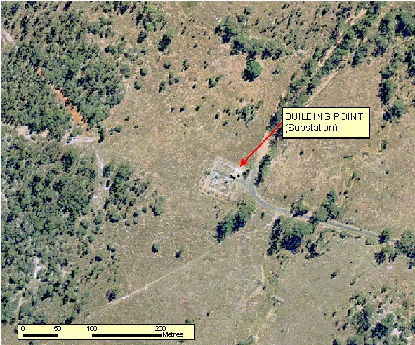
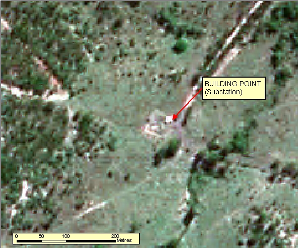
- As shown in Figure: 2.1.10.2a the complex depicting the Substation layout can be normally seen on ortho-photography, however only capture the Building associated with this feature.
- As shown in Figure: 2.1.10.2b Substations are difficult to interpret from Spot imagery and would probably need to be supplemented with revision material to proper identify this feature. The Building is visible, but cannot be interpreted alone.
- Substations generally are a central hub of connectivity for a Powerline network.
- A Fence line boundary is normally visible to exclude public access.
|
| Regional Considerations: |
|
| Figure: 2.1.10.2 Representation of a Substation in association with surrounding features. |
[back to top]
2.1.10.3 Example 3
| |
| Location of Example: |
152°15'25" East, 24°55'51" South |
| Distinctive Characteristics: |
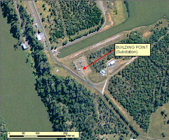
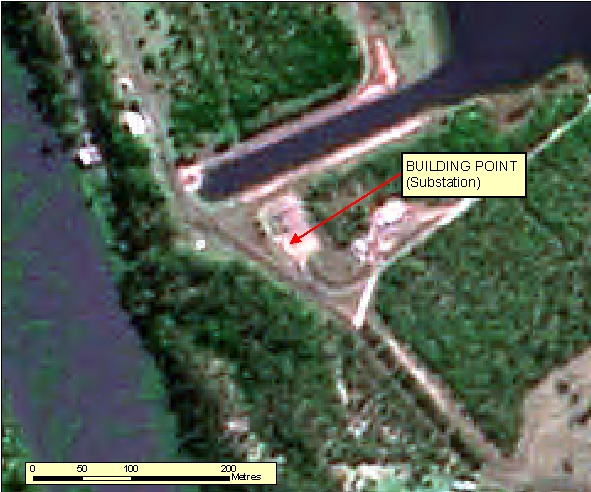
- As shown in Figure: 2.1.10.3a the complex depicting the Substation layout can be normally seen on ortho-photography, however only capture the Building associated with this feature.
- As shown in Figure: 2.1.10.3b Substations are difficult to interpret from Spot imagery and would probably need to be supplemented with revision material to proper identify this feature. The Building is visible, but cannot be interpreted alone.
- Substations generally are a central hub of connectivity for a Powerline network.
- A Fence line boundary is normally visible to exclude public access.
|
| Regional Considerations: |
|
| Figure: 2.1.10.3 Representation of a Substation in association with surrounding features. |
[back to top]
2.1.11 Built Up Area Delineation
2.1.11.1 Example 1
| |
| Location of Example: |
153°01'13" East, 27°41'44" South |
| Distinctive Characteristics: |
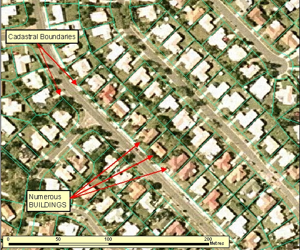
- Figure: 2.1.11.1 is an example of part of a Built Up Area in densely populated new suburbs of a capital city.
- A Built Up Area will be representative of all buildings which are set out on street patterns.
- The boundaries of a Built Up Area should be defined with consideration to the surrounding landscape and location in Australia (e.g. middle of the Northern Territory versus older suburbs in a capital city versus newer suburbs in a fast growing satellite town).
- In General, Built Up Areas should consist of the majority of land parcels being less than 3600 square metres and man-made structures (e.g pools, homes, garages, etc) should occupy greater than approximately 15 percent of the land parcel.
|
| Regional Considerations: |
|
| Figure: 2.1.11.1 Representation of a Built Up Area. |
[back to top]
2.1.11.2 Example 2
| |
| Location of Example: |
153°01'12" East, 27°41'51" South |
| Distinctive Characteristics: |
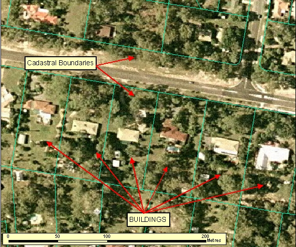
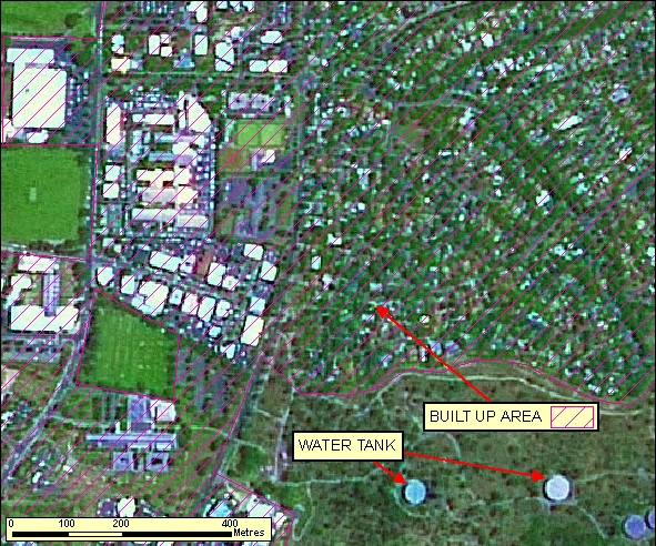
- Figure: 2.1.11.2 is an example of the peri-urban zone outside a Built Up Area. This should not be captured as a Built Up Area.
- A Built Up Area will be representative of all buildings which are set out on street patterns.
- The boundaries of a Built Up Area should be defined with consideration to the surrounding landscape and location in Australia (e.g. middle of the Northern Territory versus older suburbs in a capital city versus newer suburbs in a fast growing satellite town).
- In General, Built Up Areas should consist of the majority of land parcels being less than 3600 square metres and man-made structures (e.g pools, homes, garages, etc) should occupy greater than approximately 15 percent of the land parcel.
|
| Regional Considerations: |
|
| Figure: 2.1.10.2 Representation of a peri-urban zone outside of a Built Up Area |
[back to top]
2.1.11.3 Example 3
| |
| Location of Example: |
153°01'12" East, 27°41'51" South |
| Distinctive Characteristics: |
- A Built Up Area will be representative of all buildings which are set out on street patterns.
- The boundaries of a Built Up Area should be defined with consideration to the surrounding landscape and location in Australia (e.g. middle of the Northern Territory versus older suburbs in a capital city versus newer suburbs in a fast growing satellite town).
- In General, Built Up Areas should consist of the majority of land parcels being less than 3600 square metres and man-made structures (e.g pools, homes, garages, etc) should occupy greater than approximately 15 percent of the land parcel.
|
| Regional Considerations: |
|
| Figure: 2.1.11.3 Representation of a Built Up Area |
[back to top]
2.1.11.4 Example 4
| |
| Location of Example: |
149°05'55" East, 35°19'18" South |
| Distinctive Characteristics: |
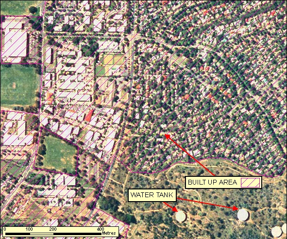
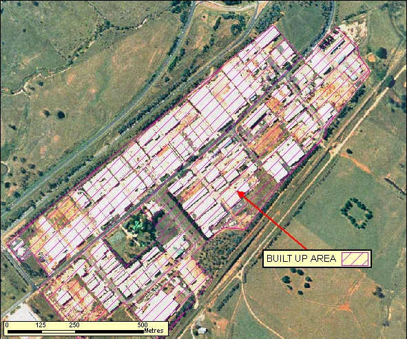
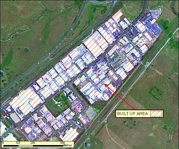
- A Built Up Area will be representative of all buildings which are set out on street patterns.
- The boundaries of a Built Up Area should be defined with consideration to the surrounding landscape and location in Australia (e.g. middle of the Northern Territory versus older suburbs in a capital city versus newer suburbs in a fast growing satellite town).
- In General, Built Up Areas should consist of the majority of land parcels being less than 3600 square metres and man-made structures (e.g pools, homes, garages, etc) should occupy greater than approximately 15 percent of the land parcel.
|
| Regional Considerations: |
|
| Figure: 2.1.11.4 Representation of a Built Up Area |
[back to top]
2.1.12 Miscellaneous Areas
2.1.12.1 Example 1
| |
| Location of Example: |
152°19'24" East, 24°53'36" South |
| Distinctive Characteristics: |
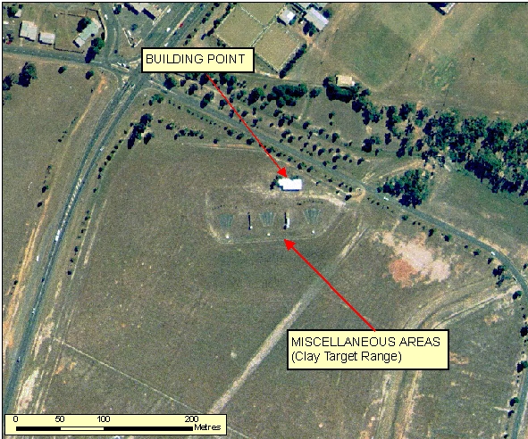
- Figure: 2.1.12.1 shows a Clay Target Range. This can be distinguished by the regular lines terminating at a fixed target.
|
| Regional Considerations: |
|
| Figure: 2.1.12.1 Representation of a Clay Target Range in association with surrounding features. |
|
