This is a regional Otway Basin interpretive data product, it builds on the Otway Basin Regional Study, released in 2021. This product is the final component that enables the user to integrate interpretative data with the OB2020 seismic survey and reprocessed legacy 2D data which was provided along with the report for the regional interpretation and petroleum system modelling for the Deep-water Offshore Otway Basin. These data are provided in a vendor neutral data format package, in both time and depth domains.
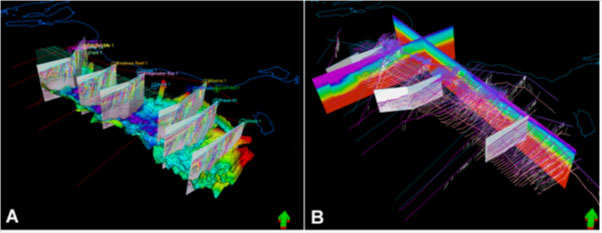
Figure 1. A) Example of the indicative 3D depth domain interpretation data, showing the six 2D seismic PSM composite lines, a gridded horizon and key well ties. B) Example of the regional 3D interval velocity model and some of the two-way-time interpretation of major sequence boundaries along OB2020 seismic survey, 2D PSM lines and 2020 reprocessed seismic data Offshore Otway Basin
The data package contains;
- depth and time domain interpretive data, which was used as the input to Petroleum Systems Modelling (PSM)
- broader interpretation as time and depth domain interpreted horizons and grids
- cultural data
- well data
- SEG-Y for the Petroleum Systems Modelling 2D composite lines from the Regional Study
- 3D Interval velocity volume in SEG-Y.
- A short report provides details of data types, formats and provides an appendix listing of other data available via NOPIMS to use in conjunction with this product.