Onshore Seismic and Magnetotelluric project
Page last updated:14 December 2023
Geoscience Australia has more than 60 years experience in land seismic surveys and since 1980 has acquired in excess of 24000 kilometres of onshore deep crustal seismic reflection data and numerous 2D seismic refraction profiles.
The key objectives of the Onshore Seismic and Magnetotelluric project (OSMT) are to:
- Manage and deliver the seismic and MT data acquisition and processing on behalf of Geoscience Australia and its collaborators through National Collaboration Agreements
- operate the Geoscience Australia component of the National Research Facility for Earth Sounding (ANSIR) in conjunction with the Australian National University and the University of Adelaide by acquiring seismic and MT datasets for eligible research projects
- maintain and develop legacy onshore seismic datasets and respond to client requests for seismic and ancillary data.
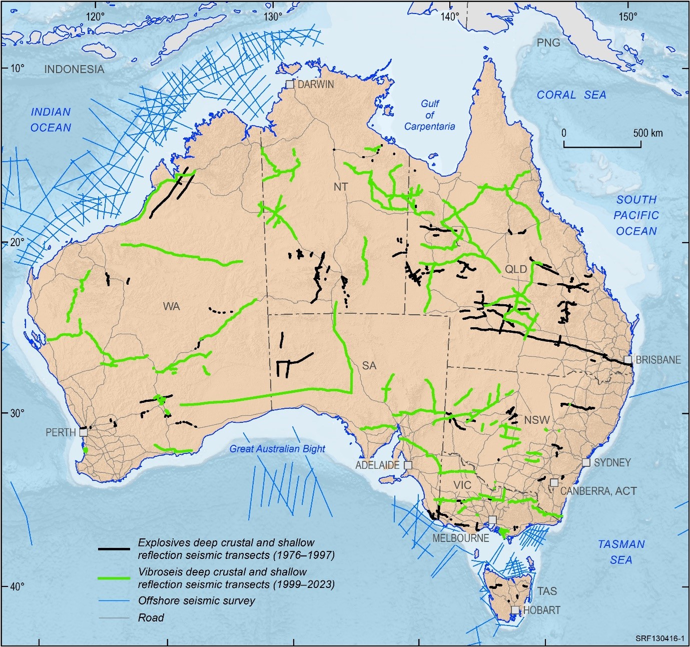
Figure 1. Map of Australia showing all the survey lines


Achievements to Date
Complete Datasets (1949-present)
Processed SEG-Y data, images and metadata of seismic surveys are available for download.
Seismic datasets by state:
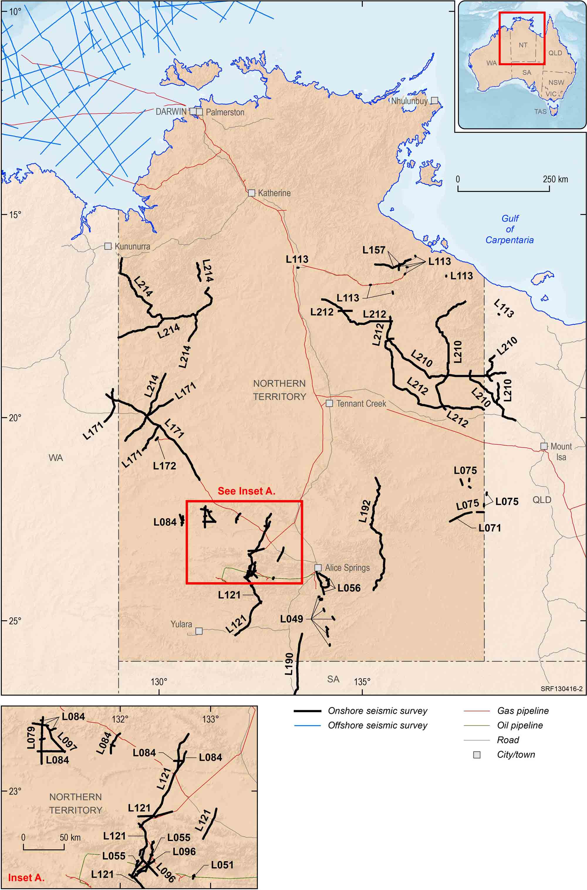
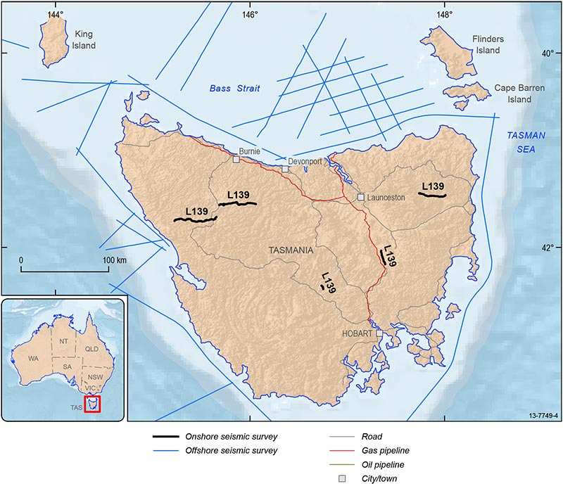
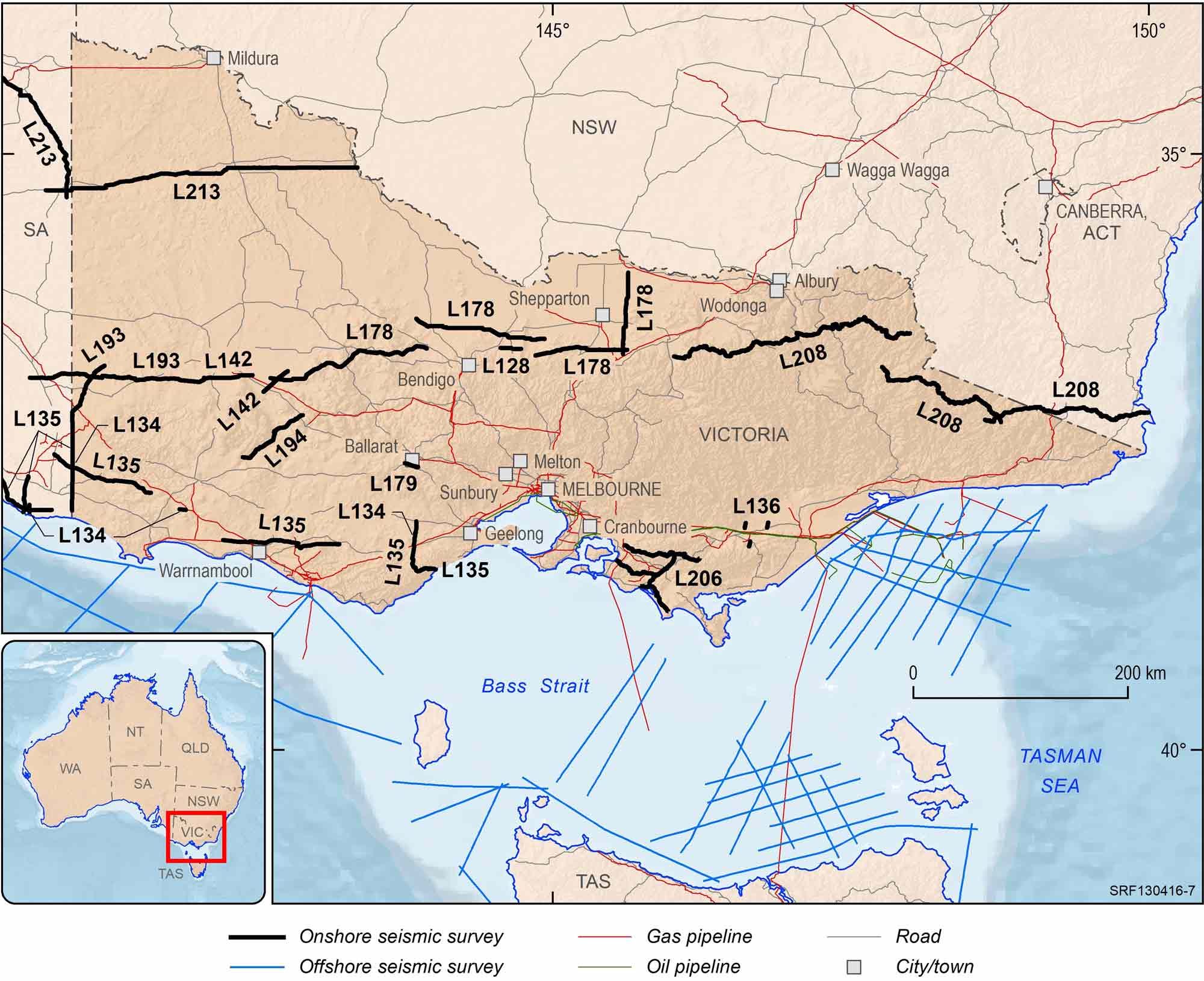
The location of onshore seismic lines are shown in each state on the seismic map gallery above.
Deep Crustal Seismic Reflection Profiles
In a joint venture between Geoscience Australia and the Australian National University, images of seismic reflection data which were collected over more than 30 years have been compiled into a single publication. The compilation includes groupings of multiple large-scale reflection transect over 1000 kilometres or more that link across major geological provinces. The reflection profiles cover many different geological environments. The profiles are at 1:1 a horizontal to vertical scale and are accompanied by a geological strip map showing the configuration of the profile and its relation to other nearby seismic lines. The compilation includes an extensive bibliography of reports and relevant publications. The Deep Crustal Seismic Reflection Profiling Australia 1978–2015 is available from ANU E Press as a free download.
Recent Datasets
Table 1 lists the seismic surveys, their length, the data types acquired and the planned dates for release of the processed data.
Table 2 lists the magnetotelluric surveys, the number of stations and the planned dates for release of the processed data.
- Table 1 - OESP Deep Crustal Seismic Program (2006-2011) and 2012-2015 Seismic Surveys
- Table 2 - OESP Magnetotelluric Surveys
- GIS dataset of Onshore Seismic Surveys (updated May 2019)
Cloncurry Magnetotelluric Survey
Geoscience Australia and the Geological Survey of Queensland conducted the Cloncurry Magnetotelluric (MT) survey between July and November 2016. The survey area covers the eastern margin of the Mount Isa Inlier in the north of Cloncurry. MT data were acquired at 476 sites with a grid spacing 2 km. The data can be used for mapping the basement architecture and the crustal architecture in this region.
Bonaparte Basin 2D Reflection Land Seismic Reprocessing
Geoscience Australia commissioned reprocessing of selected legacy 2D seismic data in the East Kimberley, onshore Bonaparte Basin (Figure 19.) as part of the Exploring for the Future (EFTF) program. Reprocessing of these data occurred between September 2017 and May 2018.
Exploring for the Future was a $100.5 million four-year (2016-20), Australian Government-funded program to provide a holistic picture of the potential mineral, energy and groundwater resources in northern Australia. The program has delivered new geoscience data, knowledge and decision support tools to support increased industry investment and sustainable economic development across the north.
Groundwater is a critical resource that accounts for most water used across northern Australia. The groundwater component of the EFTF program focused on addressing groundwater resource knowledge gaps, to support future opportunities for economic development via irrigated agriculture, extractive industries and increased security of community water supplies. Through collaboration with State and Territory partners, the program undertook targeted regional investigations of groundwater systems and assessments of groundwater potential more broadly across the region.
The program's activities, implemented by Geoscience Australia, involved application of innovative geoscience tools to collect, integrate and analyse a range of data. It includes geological and hydrogeological data, airborne and ground-based geophysical and hydrogeochemical surveys, remote sensing data as well as stratigraphic drilling. The new data and better understanding of groundwater systems also helps inform decision making about groundwater use to protect environmental and cultural assets. These outcomes strengthen investor confidence in resources and agricultural projects by de-risking groundwater in northern Australia.
The package contains reprocessed data from ten surveys acquired between 1980 and 1997. In total 53 lines were reprocessed covering a fold area of approximately 618.9 line kilometres, with the objective to produce a modern industry standard 2D land seismic reflection dataset where possible from a selection of multiple legacy 2D data.
The purpose of the reprocessing was twofold:
- To image the near surface structural and stratigraphic configuration for linking to AEM data that is available in the Bonaparte Basin; and
- To image the structure and stratigraphic architecture of the Paleozoic Bonaparte Basin.
The dataset exhibits significant improvements in stack response in most of the reprocessed lines when final and legacy stacks were compared, especially in the shallow section. Optimum results were obtained from the noise attenuation workflows. A minimum processing flow was applied to BWA80, BWA81, and line BNT87-404 lines to avoid any signal leakage throughout the processing.
Final data were delivered as minimum phase (care should be taken not to interpret zero crossings as geological boundaries), and final velocities produced a good match with the well checkshot velocities. The processing report from Down Under Geophysics is available for download with this release.
Raw and processed data are available on request from clientservices@ga.gov.au - Quote eCat# 135578.
Processed stack SEG-Y files and ancillary data are available for download from this web page.
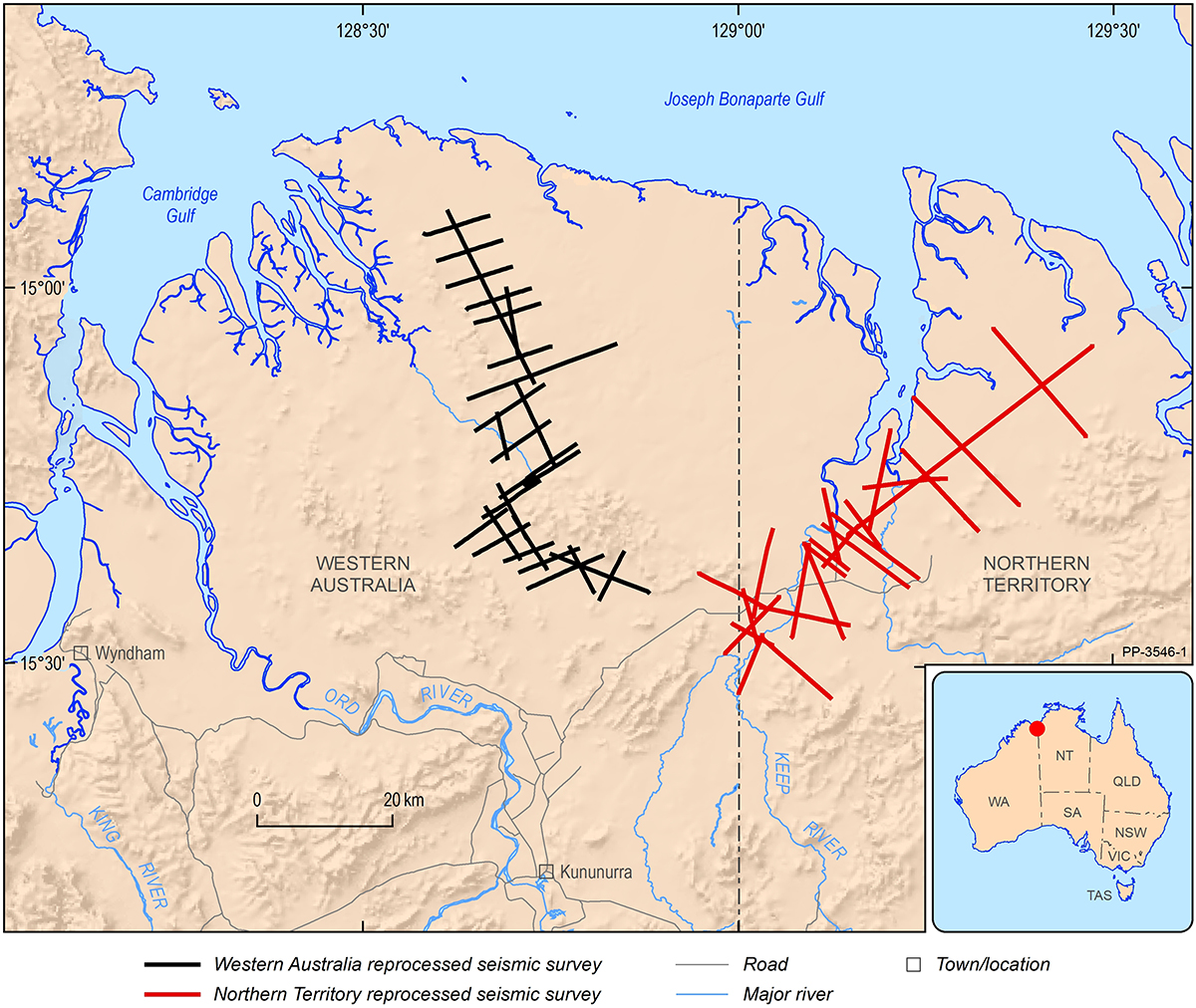
Figure 19. Locations of the seismic lines reprocessed in 2017-18. Data acquired between 1980 and 1987.
L213 Darling-Curnamona-Delamerian 2D Seismic Survey
The Darling-Curnamona-Delamerian (DCD) 2D reflection seismic survey was acquired during May to August 2022 in the Delamerian Orogen, the Murray-Darling basin, the Curnamona Province, and the upper Darling River floodplain regions in South Australia, Victoria and New South Wales. This project is a collaboration between Geoscience Australia (GA), the Geological Survey of South Australia (GSSA), the Geological Survey of Victoria (GSV) and the Geological Survey of New South Wales (GSNSW) and was funded by the Australian Government’s Exploring for the Future (EFTF) program. The overall objective of the EFTF Darling-Curnamona-Delamerian project is to improve the understanding of mineral and groundwater resources of the Curnamona Province and Delamerian Orogen and overlying basin systems through acquisition and interpretation of new pre-competitive geoscience data sets.
The total length of acquisition was 1256 km distributed over five deep crustal 2D reflection seismic lines 22GA-DL1 (446 km), 22GA-DL2 (249 km), 22GA-CD1 (287 km), 22GA-CD2 (178 km), 22GA-CD3 (39.5 km) to image deep crustal structures, and a high-resolution 2D reflection seismic line 22GA-UDF (56 km) to explore groundwater resources. The DL lines provide coverage of fundamental geophysical data over the Flinders Range, the Delamerian Province and the Murray-Darling basin region in eastern South Australia and Victoria. The CD lines extend through the Curnamona Province and into the Darling Basin. The UDF line will assist with refining the hydrogeological model, understanding groundwater dynamics, and locating areas better suited to groundwater bores for better quality groundwater in the upper Darling River floodplain area.
The data processing was performed by a contractor under the supervision of Geoscience Australia. The five deep crustal lines (22GA-DL1,DL2,CD1,CD2,CD3) were processed with record lengths of 20 and 8 seconds, while the shallow high-resolution line (22GA-UDF) was processed at a 4 second length. This processing yielded DMO Stack, Post-Stack Time Migration, and Pre-Stack Time Migration products.
Raw data for this survey are available on request from clientservices@ga.gov.au - Quote eCat# 147423
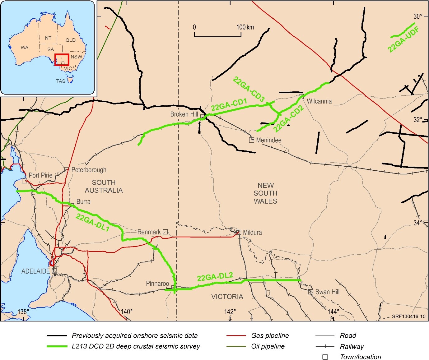
Location map of the Darling-Curnamona-Delamerian Seismic Survey in SA, VIC and NSW
L212 Barkly 2D Seismic Survey
The Barkly 2D Seismic Survey was acquired during September to November 2019 and commenced near the town of Camooweal on the border of Queensland and Northern Territory. This project is a collaboration between Geoscience Australia (GA) and the Northern Territory Geological Survey (NTGS), and was funded by the Australian Government's Exploring for the Future program and the Northern Territory Geological Survey under Resourcing the Territory initiative.
The Barkly seismic survey extends the 2017 South Nicholson seismic survey and links with the existing Beetaloo Sub-basin seismic data. The total length of acquisition was 812.6 km spread over five lines 19GA-B1 (434.6 km), 19GA-B2 (45.9 km), 19GA-B3 (66.9 km), 19GA-B4 (225.8 km) and 19GA-B5 (39.4 km). The Barkly seismic project provides better coverage and quality of fundamental geophysical data over the region from the southern McArthur Basin to northern Mt Isa western succession. The Barkly seismic data will assist in improving the understanding of basins and basement structures and also the energy, mineral and groundwater resource potential in Northern Australia. The new reflection seismic data and derivative information will reduce the risk for exploration companies in this underexplored area by providing information for industry to confidently invest in exploration activities. Raw data are available on request from clientservices@ga.gov.au.
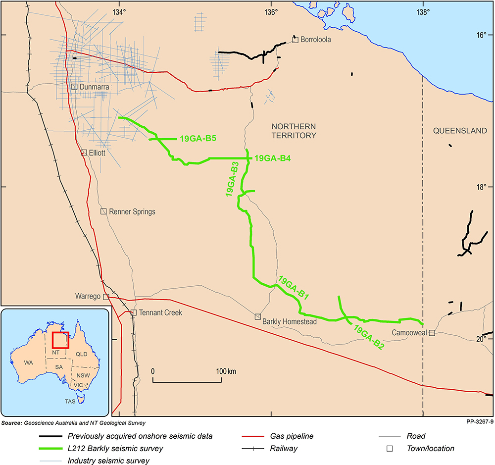
Figure 18. Location Map of Barkly Seismic Survey in NT
L211 Kidson Sub-Basin Seismic Survey
Eight hundred and seventy two km of gravity and deep crustal reflection data were collected for the Kidson Sub-Basin 2D seismic survey along a single transect: 18GA-KB1 during June to August 2018. The purpose of the survey was to image basin and basement structures of the Kidson Sub-Basin of the onshore Canning Basin, and extending across the Paterson Orogen and on to the eastern margin of the Pilbara Craton. The new data will help geological interpretations to determine the stratigraphy, lateral extent and stratigraphic relationships of the basin and adjoining terranes, and an assessment of the region for its oil and gas and mineral potential. The project is a collaboration between Geoscience Australia (GA) and the Geological Survey of Western Australia (GSWA) and was funded by the Australian Government's Exploring for the Future program and the Western Australian Government's Exploration Incentive Scheme (EIS). The data processing was undertaken by a contractor on behalf of GA and GSWA, and was completed in May 2019. Raw data are available on request from clientservices@ga.gov.au.
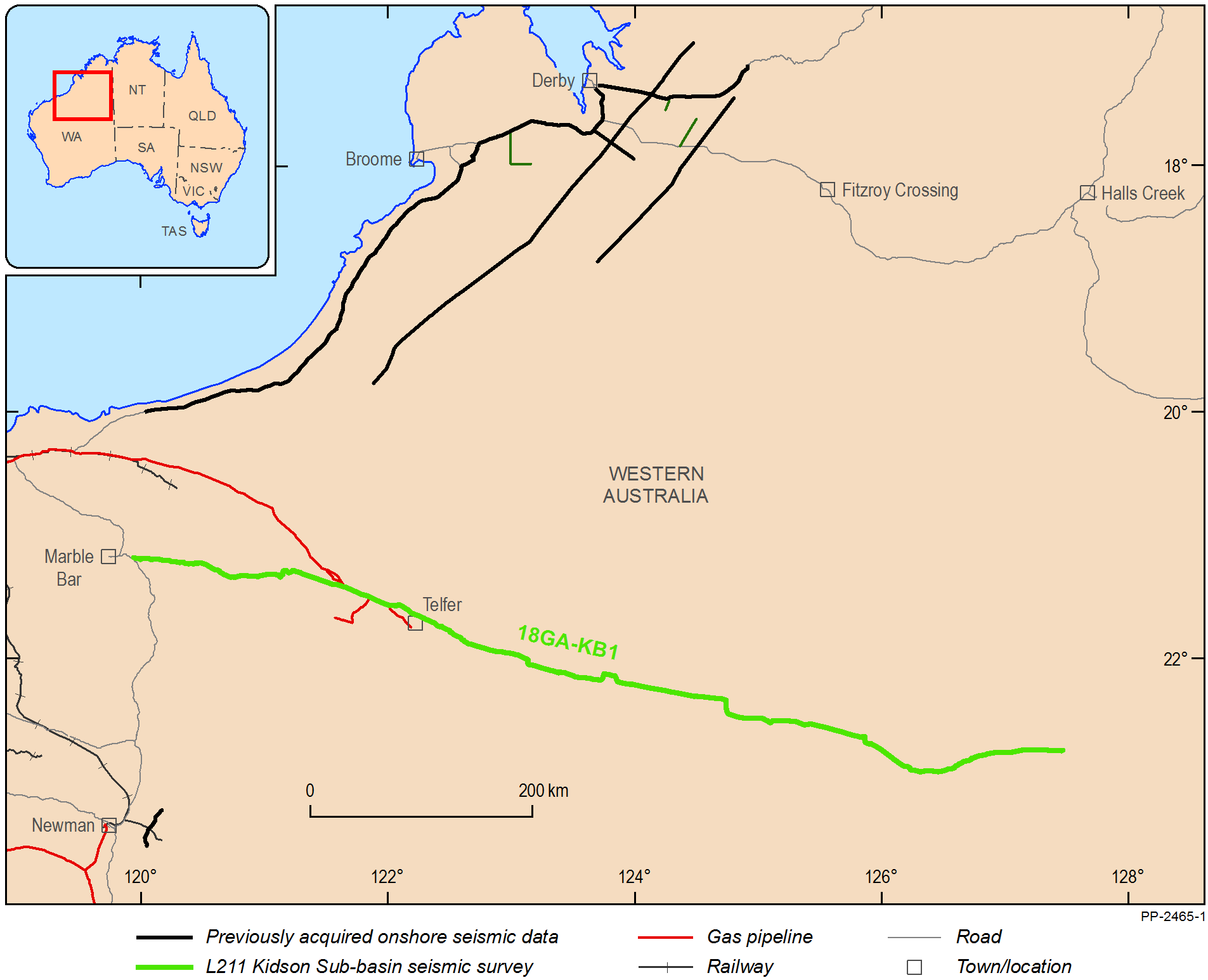
Figure 17. Location Map of Kidson Sub-Basin Seismic Survey in WA
L210 South Nicholson Seismic Survey
During June to August 2017, Geoscience Australia acquired 1102 km of deep crustal seismic reflection data in five traverses: 17GA-SN1 (374.5 km), 17GA-SN2 (213.1 km), 17GA-SN3 (64.1 km), 17GA-SN4 (98.1 km) and 17GA-SN5 (352.4 km) in the region between the southern McArthur Basin and the Mt Isa western succession, crossing the South Nicholson Basin and Murphy Province. The objective of this project was to explore exposed and undercover sedimentary basins and structures to better understand the location and scale of potential energy resources. The seismic data will also support mineral exploration through the improved understanding of the region's geological evolution and identification of geological terrains with greater mineral potential. The project was a collaboration between Geoscience Australia (GA), The Geological Survey of the Northern Territory (GSNT), the Geological Survey of Queensland (GSQ) and AuScope, and was funded by the Australian Government's Exploring for the Future program. The data processing was undertaken by a contractor on behalf of GA, GSNT and GSQ, and was completed in June 2018. Raw data are available on request from clientservices@ga.gov.au
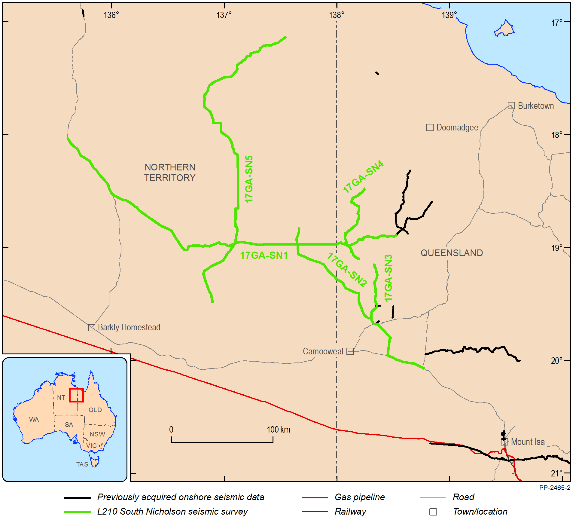
Figure 16. Location Map of South Nicholson Seismic Survey in QLD and NT
L208 Southeast Lachlan Seismic Survey
Six hundred and twenty nine km of deep crustal reflection data were collected for the Southeast Lachlan 2D seismic survey along three transects: 18GA-SL1 (302 km), 18GA-SL2 (163 km) and 18GA-SL3 (164 km) during March to April 2018. The purpose of the survey was to image the Tabberabbera, Omeo, Deddick, Kuark and Mallacoota Zones (west to east) of the Lachlan Orogen at a high angle to their structural grain, as a key reference section for the study of the Palaeozoic geology, geodynamic evolution and mineral potential of Victoria and New South Wales with implications for eastern Australia mineral exploration as well as natural hazard mapping. The Project is a collaboration between Geoscience Australia (GA), the Geological Survey of Victoria (GSV), the Geological Survey of New South Wales (GSNSW), and AuScope. Raw data are available on request from clientservices@ga.gov.au
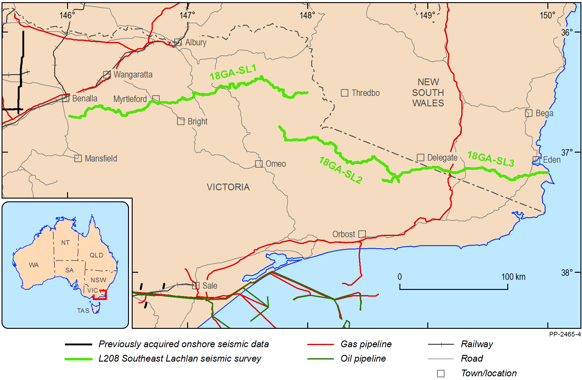
Figure 15. Location Map of Southeast Lachlan Seismic Survey in VIC and NSW
L207 Boulia Seismic Survey
Seven hundred and seven km of deep crustal reflection data were collected for a Boulia Region seismic survey along two transects: 14GA-CF2 (368 km) and 14GA-CF3 (339 km) during November 2014 to January 2015. An additional 146 km of deep crustal reflection data were collected for a Boulia Extension Seismic Survey along a single transect 15GA-CF3 with an overlap of 6 km with 14GA-CF3 transect in May 2015. The survey involved the acquisition of seismic reflection and gravity data. The purpose of the survey was to develop an understanding of the structural architecture, kinematic history and tectonic context of the major 'greenfields' province; determine the variability of the depth to mineralised basement; and identify potentially prospective Neoproterozoic rift basins. The Project is a collaboration between Geoscience Australia and Geological Survey of Queensland and funded under Queensland Government's Future Resources (Mount Isa Geophysics) Program. Raw data are available on request from clientservices@ga.gov.au
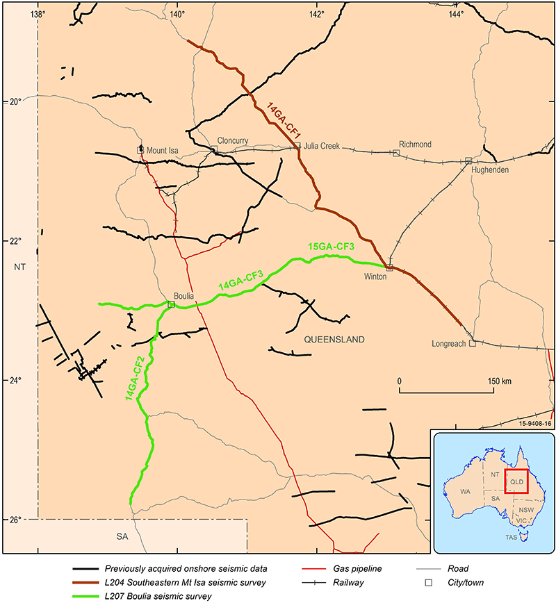
Figure 2. Location Map of Boulia Seismic Survey and Southeastern Mt Isa Seismic Survey in QLD
L206 South Gippsland Seismic Survey
2D seismic reflection data were acquired in the South Gippsland region of Victoria in June-July 2015. The project was a collaboration between the Geological Survey of Victoria and Geoscience Australia. The purpose of the survey was to gain an understanding of the geometry and internal structure of the Cretaceous Strzelecki Group and the underlying Palaeozoic basement of the Melbourne Zone. Two hundred and three km of deep crustal reflection data were collected for the South Gippsland seismic survey along four transects 15GA-SG1, 15GA-SG2, 15GA-SG3 and 15GA-SG4. Raw data are available on request from clientservices@ga.gov.au
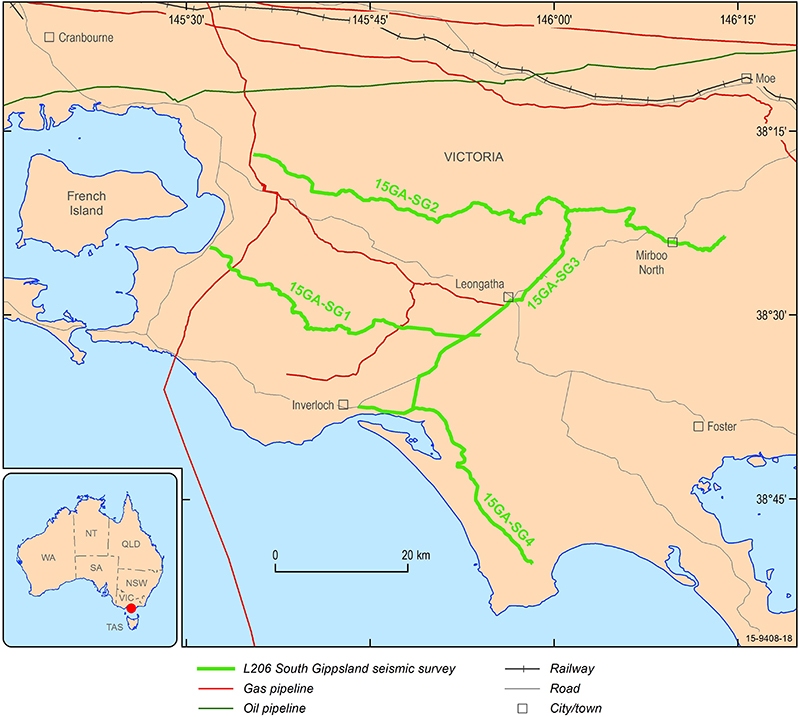
Figure 3. Location Map South Gippsland Seismic Survey in Victoria
L205 Canning Coastal Seismic Survey
In May-June 2014 Geoscience Australia in collaboration with the Geological Survey of Western Australia acquired 705 km of deep crustal seismic and gravity data along two lines 14GA-CC1 (562km) and 14GA-CC2 (143km) between Port Hedland and Derby, WA. The main objectives of the project were to image the crustal architecture of the geology underlying the Canning Basin and its relationship to the boundaries between the crystalline hard rock areas of the North (Kimberley) and West Australian (Pilbara) cratons; establish the subsurface extent of the Canning Basin and the extent and nature of its sub-basins and troughs. The project was funded by Western Australian State Government's Royalties for Regions Exploration Incentive Scheme. Data were processed by a contractor on behalf of GA and GSWA. Selected data and images are available for download, raw SEGD data and a full processed data set including Pre-Stack Time Migration (PSTM), Pre-Stack Depth Migration (PSDM), Post-Stack Migration, Angle Stacks and CDP gathers in SEGY format are available on request from clientservices@ga.gov.au
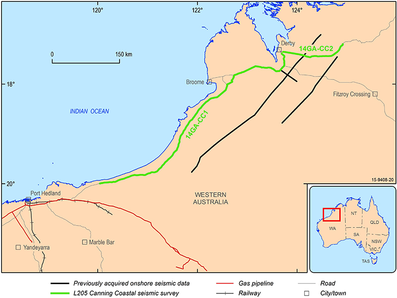
Figure 4. Location Map Canning Coastal Seismic Survey in WA
L204 Southeastern Mt Isa Seismic Survey
A 670 km deep crustal seismic transect 14GA-CF1 runs along the gazetted road corridor from Longreach to Canobie, terminating further north near Four Ways, Queensland. The seismic and gravity data were collected along this transect during April-May 2014 as a part of collaborative project between Geoscience Australia and Geological Survey of Queensland under the Queensland Government's Greenfields 2020 Program. The main objective of the project was to image the Cork Fault zone and investigate the influence of basement structures on the localisation and development of mineral systems along this fault, and determine the variability of the depth to prospective basement. The fault zone and the southern margin of the Mount Isa Inlier are considered to have significant potential for hosting large or even giant ore deposits comprising mineral commodities such as iron-oxide-copper-gold, uranium, and platinum-nickel. Raw data are available on request from clientservices@ga.gov.au
L203 Eucla-Gawler Seismic Survey
Deep crustal seismic reflection data along the 830 km Eucla-Gawler transect 13GA-EG1 were acquired during November 2013 to February 2014 as a part of collaborative project between Geoscience Australia, the State Government's Geological Survey of South Australia, the Geological Survey of Western Australia and AuScope. The line crosses the Eucla Basin and runs along the Trans Railway Line Access road from Haig in Western Australia through to Tarcoola in South Australia. The purpose of the survey was to image the crustal architecture of the geology underlying the Eucla Basin and its relationship to the Gawler Craton to the east and the Yilgarn Craton to the west; to establish the subsurface extent of the Eucla Basin and image any large structural zones that may have provided fluid pathways for mineralisation. Raw data are available on request from clientservices@ga.gov.au
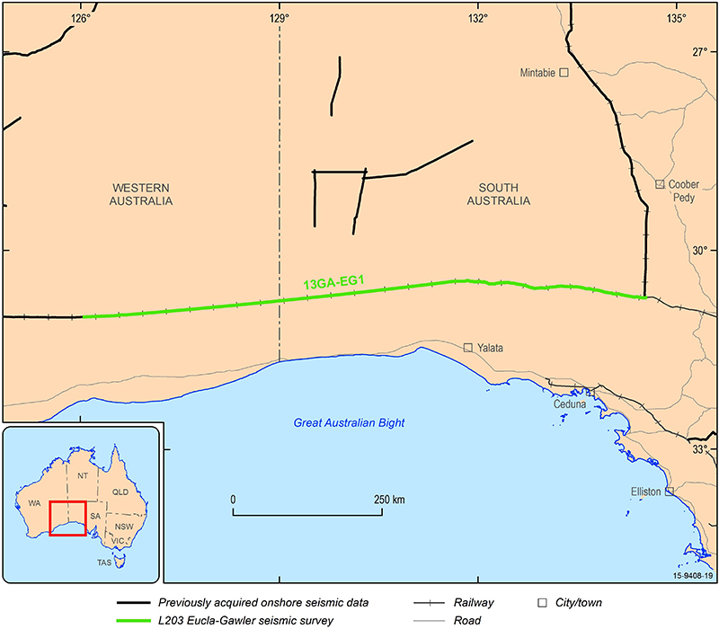
Figure 6. Location Map Eucla-Gawler Seismic Survey in WA
L202 Yathong Trough Seismic Survey
Geoscience Australia in collaboration with Geological Survey of New South Wales as a part of the NSW New Frontiers Initiative conducted the Yathong Trough 2D Seismic Survey in 2013. Two hundred and thirty km of the deep crustal seismic reflection data were collected along two lines 13GA-YT1 (98km) and 13GA-YT2 (132 km) in the Yathong Trough of the Darling Basin. The purpose of the survey was to provide a new dataset on the regional geology and image major structures of the Yathong Trough within the Darling Basin. Raw data are available on request from clientservices@ga.gov.au
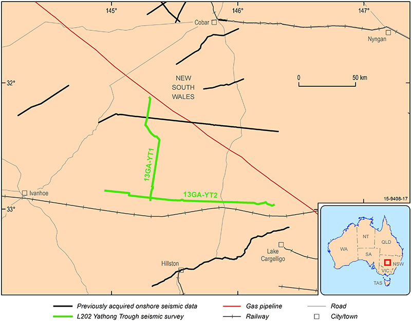
Figure 7. Location Map of Yathong Trough Seismic Survey in NSW
L201 Albany-Fraser Orogen
Geoscience Australia conducted the Albany-Fraser Orogen 2D Seismic Survey in 2012. The survey involved the acquisition of seismic reflection and gravity Data over the Yilgarn Craton margin and the Albany-Fraser Orogen of Western Australia. The survey consisted of four lines, totalling 672 kilometres. The project is collaboration between Geoscience Australia and the Geological Survey of Western Australia and was funded through the Western Australian Government's Royalties for Regions Exploration Incentive Scheme. The primary objective was to image the crustal architecture of the Yilgarn Craton margin and its relationship to the Albany Fraser Orogen, establish the subsurface extent of the Yilgarn Craton beneath the Albany-Fraser Orogen, and identify any mantle-tapping structures that may have provided fluid pathways for mineralization.
A 70 kilometre long deep crustal seismic line was also acquired near the Tropicana Gold mine with the assistance of AuScope Earth Imaging, Anglo Gold Ashanti and the Independence Group. The purpose of this line was to understand the structural geometry around the Tropicana gold deposit and help define prospective areas elsewhere along the belt. Raw data are available on request from clientservices@ga.gov.au
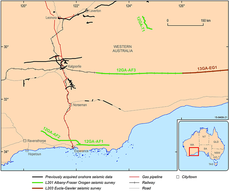
Figure 8. Location Map Albany-Fraser Orogen Seismic Survey in WA
L200 Southern Carnarvon Seismic Survey
The Southern Carnarvon survey imaged the Byro Sub-basin, an under-explored depocentre with both hydrocarbon and geothermal energy potential in the onshore section of the Carnarvon Basin, Australia's premier petroleum producing province (see Figure 9). The survey was conducted in May 2011 and final data and images were released in September 2012.
L199 Yilgarn-Officer-Musgrave Seismic and MT Survey
In June and July 2011, 487km of seismic reflection, gravity, MT and wide angle refraction data were acquired over the western Officer Basin, another of Australia's under-explored sedimentary basins with hydrocarbon potential. The survey data will build on the geoscientific knowledge of the architecture of Australia's crust and the relationship with the western Yilgarn and central Musgrave cratons and the overlying Officer Basin (see Figure 9). Final processed data and images were released in January 2013.
L196 GSWA Youanmi Seismic and MT Survey
From May to August 2010, 695 kilometres of seismic reflection, gravity and MT data were acquired over the Youanmi Terrane and Eastern Goldfields Superterrane of the Yilgarn Craton (10GA-YU1, 10GA-YU2 and 10GA-YU3) (see Figure 9). Final processed data and images were released in August 2012.
L195 AuScope/GSWA Capricorn Seismic Survey
From April through to May 2010, 581 kilometres of seismic reflection and gravity data was acquired in the Pilbara/Gascoyne region of Western Australia (10GA-CP1, 10GA-CP2 and 10GA-CP3). This was a collaborative project between Geoscience Australia, the Geological Survey of Western Australia (GSWA) and AuScope Earth Imaging (a component of NCRIS). The aim of the survey was to image the extent of the Archean crust beneath the Capricorn Orgeny and identify the relationship between the Pilbara and Yilgarn cratons (see Figure 9). The processed data and images are available to industry and a public workshop releasing the interpreted data was conducted in Perth on 23 November 2011.
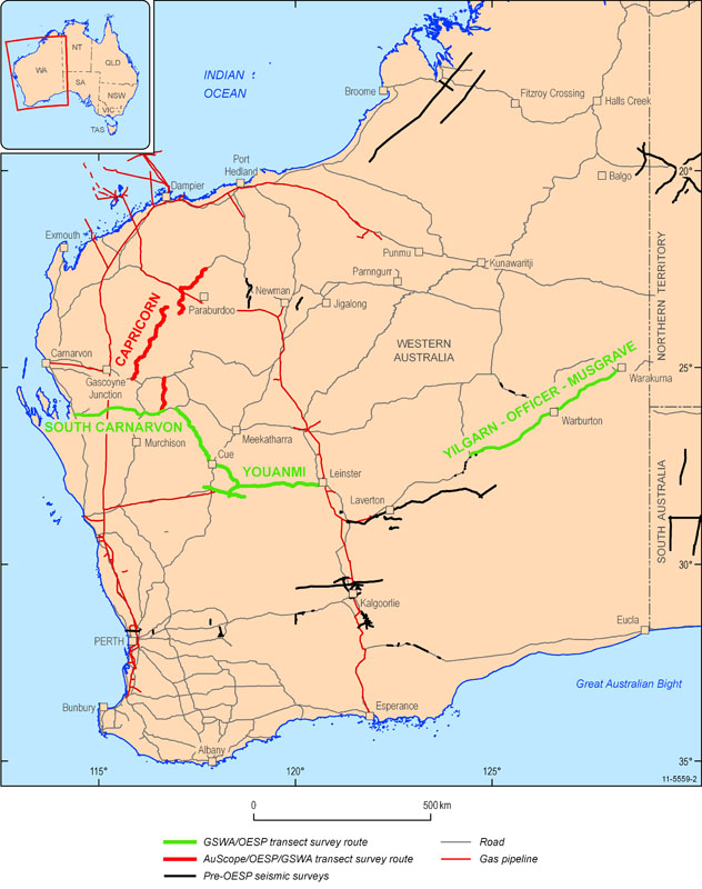
Figure 9. Map of survey lines in Western Australia
L194 Ararat Seismic Survey
This survey was acquired directly after the Southern Delamerian survey and consists of a 69.9 kilometres traverse (09GA-AR1) that crosses the boundary between the Delamerian and Lachlan orogens (see Figure 10). GSV provided the majority of funding for this survey with Geoscience Australia providing the project management and processing through OESP funding. The raw data is available from clientservices@ga.gov.au
L193 AuScope Southern Delamerian Seismic Survey
During November 2009, 197 kilometres of seismic reflection and gravity data were acquired over two traverses in the Southern Delamerian Province (09GA-SD1 and 09GA-SD2) (see Figure 10). This survey was primarily funded by AuScope. GeoScience Victoria (GSV) co-contributed towards this survey with Geoscience Australia providing project management and processing. The processed seismic data is available to industry.
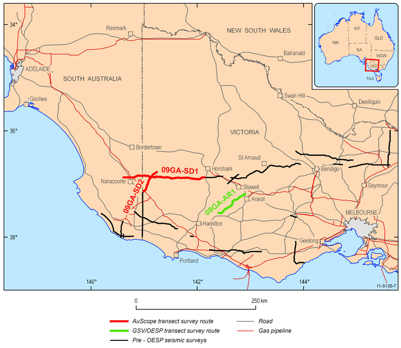
Figure 10. Map of the AuScope Southern Delamerian seismic survey line
L192 Georgina Basin Arunta Inlier Seismic Survey
During June and July 2009, 373 kilometres of seismic reflection, MT and gravity data were acquired along a north-south trending traverse commencing in the Paleoproterozoic Davenport Province. The traverse then crossed the Georgina Basin, Arunta Inlier into the top of the Amadeus Basin (see Figure 11). The aim of the survey was to image fundamental controlling structures of basin development, and to shed light on deformation and fault reactivation expected from the Silurian to Carboniferous Alice Springs Orogeny. The raw seismic data is available on request from clientservices@ga.gov.au

Figure 11. Map of the Georgina Basin Seismic survey line
L191 Curnamona-Gawler Link
In January 2009, seismic data were acquired along a traverse which crossed from the Gawler Craton to the Curnamona Province (09GA-CG1) see (Figure 12). This survey was jointly funded by PIRSA and Geoscience Australia through the OESP. A total of 145 kilometres of new seismic data were acquired. The traverse joins onto a traverse of the Curnamona Province which was conducted in 2003-04. The interpreted processed data was released at the South Australia Seismic and MT workshop, Adelaide, May 2010.
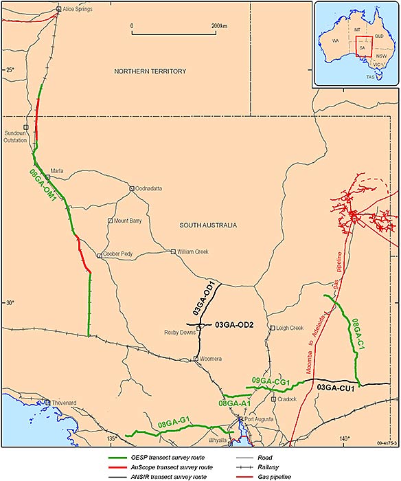
Figure 12. Map showing seismic lines in South Australia
L190 Gawler-Officer-Musgrave-Amadeus Survey (GOMA)
During November and December 2008, 634 kilometres of seismic reflection, gravity and MT data were acquired in one continuous north-south traverse beginning 25 kilometres southeast of Erldunda in the Northern Territory and completing near Tarcoola in South Australia (08GA-OM1) (see Figure 12). This traverse followed the Alice Springs to Adelaide railway line utilising the railway access road and was jointly funded by Geoscience Australia through the OESP, AuScope and Department for Manufacturing, Innovation, Trade, Resources and Energy. The uninterpreted processed seismic data and sections are now available.
The aim of this survey is to provide new insights into the crustal architecture of two Neoproterozoic sedimentary basins in Central Australia and their tectonic relationship to older (Mesoproterozoic) basement terrains. Of particular relevance is the identification of structural elements in the basinal sections which may host hydrocarbons which were generated prior to the Alice Springs Orogeny.
Raw data are available on request from clientservices@ga.gov.au
L189 Gawler-Curnamona-Arrowie
Geoscience Australia undertook acquisition of seismic reflection in South Australia as part of the OESP in June/July 2008. This survey consisted of three traverse lines, one across the Gawler province (08GA-G1, 253 kilometres), one across the Curnamona province (08GA-C1, 262 kilometres) and one in the Arrowie Basin (08GA-A1, 60.4 kilometres) (see Figure 12).
- L189 Gawler-Curnamona-Arrowie (Gawler province)
- L189 Gawler-Curnamona-Arrowie (Arrowie Basin)
- L189 Gawler-Curnamona-Arrowie (Curnamona province)
- Gawler Magnetotelluric
- Curnamona Magnetotelluric
L188 Rankins Springs Seismic Survey
The Rankins Springs-Yathong Trough Seismic Survey was the first survey of an under-explored onshore petroleum basin undertaken as part of the OESP. The deep seismic survey comprised two east-west traverse lines, one each across the Rankins Springs and Yathong Troughs in the southeastern Darling Basin in western New South Wales (see Figure 13). The survey acquired a total of 234 kilometres of seismic data in March 2008.
In February 2009 the northernmost line across the Yathong Trough was extended 32km to the east over the Central Lachlan Fold Belt. The 2008 data (08GA-RS2) was re-processed together with the 2009 data to produce the Rankins Springs Extension line (09GA-RS2).
The survey was jointly funded by the New South Wales Department of Primary Industries (NSW-DPI) and Geoscience Australia through the OESP. The raw seismic data are available on request from clientservices@ga.gov.au
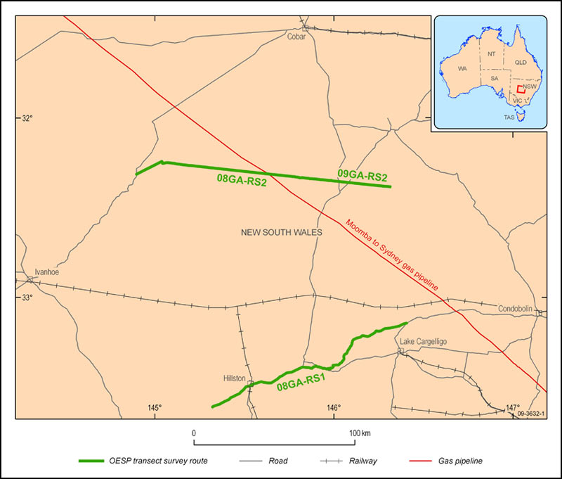
Figure 13. Map of Rankins Springs seismic survey lines
L186 AuScope
Leveraging off the timing and location of the Mount Isa-Georgetown-Charters Towers surveys, AuScope, which is a National Collaborative Research Infrastructure Scheme, funded 205 kilometres of seismic reflection line (see Figure 14). This line, 07GA-A1 was designed to image the Tasman Line and provide information on the structure and evolution of this part of the Australian continent.
The interpreted processed data was released at the North Queensland Seismic and MT Workshop, Townsville, June 2009.
L184 and L185 Isa-Georgetown-Charters Towers
During May to October 2007 Geoscience Australia in collaboration with the Geological Survey of Queensland (GSA) contracted Terrex Seismic to undertake the Isa-Georgetown and the Georgetown-Charters Towers Deep Seismic Reflection Surveys. These surveys acquired 1200 kilometres of deep seismic reflection, gravity and magnetotelluric data along three traverses, 07GA-IG1, 07GA-IG2 and 07GA-GC1 (see Figure 9).
Funding for this survey was provided by the OESP and Queensland's Smart Mining - Future Prosperity Program and was aimed at imaging from the eastern edge of the Mount Isa Province across the Georgetown Province and southeast through the Charters Towers region into the Drummond Basin.
The interpreted processed data was released at the North Queensland Seismic and MT Workshop, Townsville, June 2009.
L180 Mount Isa
In late 2006 deep crustal reflection seismic and gravity data were acquired across the Mount Isa Inlier and the Lawn Hill Platform in northwest Queensland (see Figure 14). The survey was a collaborative project between Geoscience Australia, funded through the OESP, the Queensland Government, funded through the Smart Mining - Future Prosperity Program, Zinifex Pty Ltd and the Predictive Mineral Discovery Cooperative Research Centre (pmd*CRC). A total of 900 kilometres of data over six traverses were acquired and the data was released at the Mount Isa Crustal Seismic Workshop, Mount Isa, June 2008.
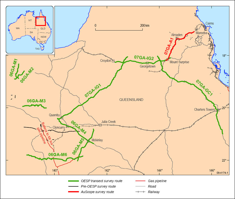
Figure 14. Map of the Isa/Georgetown/Charters Towers survey lines