Earthquake
Last updated:7 September 2022
What is an earthquake?
Earthquakes are the vibrations caused by rocks breaking under stress. The underground surface along which the rock breaks and moves is called a fault plane.
The focus, or “hypocentre”, of an earthquake is the point where it originated within the Earth. The point on the Earth's surface directly above the focus is called the earthquake epicentre.
The size or magnitude of earthquakes is determined by measuring the amplitude of the seismic waves recorded on a seismograph and the distance of the seismograph from the earthquake. These are put into a formula which converts them to a magnitude, which is a measure of the energy released by the earthquake. For every unit increase in magnitude, there is roughly a thirty-fold increase in the energy released. For instance, a magnitude 6.0 earthquake releases approximately 30 times more energy than a magnitude 5.0 earthquake, while a magnitude 7.0 earthquake releases approximately 900 times (30x30) more energy than a magnitude 5.0.
A magnitude 8.6 earthquake releases energy equivalent to about 10 000 atomic bombs of the type developed in World War II. Fortunately, smaller earthquakes occur much more frequently than large ones and most cause little or no damage.
Earthquake magnitude was traditionally measured on the Richter scale. It is often now calculated from seismic moment, which is proportional to the fault area multiplied by the average displacement on the fault.
Where do earthquakes occur?
No part of Earth's surface is immune from earthquakes, but some regions experience them more frequently than others. They are most frequent and largest at tectonic plate boundaries where two plates are colliding and/or sliding past one another. They particularly occur around the margins of the Pacific Plate, for example in New Zealand, Vanuatu, the Solomon Islands, Papua New Guinea, Japan and the Americas, and also along the Indonesian islands arc, where the Indo-Australian Plate collides with the Eurasian Plate. The depths of focus in these collision zones can range from the surface to 700 km in depth. Large shallow earthquakes also occur where two plates are pulling apart with the creation of new oceanic crust along mid-ocean ridges and on the transform faults that intersect them.
In the relatively stable interior of continents, away from plate boundaries, earthquakes are less common and do not follow easily recognisable patterns. These ‘intraplate’ earthquakes generally originate at shallow depths (i.e. less than 20 km), but can still be of large magnitude. In 1811-1812 four earthquakes of estimated magnitude >7 occurred in the New Madrid region of the eastern United States. More recently, the magnitude 7.7 2001 Bhuj earthquake in intraplate India killed more than 20,000 people.
Australia's largest recorded earthquake was in 1988 at Tennant Creek in the Northern Territory, with an estimated magnitude of 6.6. It occurred in a sparsely populated area and resulted in damage to a major gas pipeline. A magnitude 6.5 earthquake at Meckering in 1968 caused extensive damage to buildings and was felt over most of southern Western Australia. These earthquakes are two of the eleven that are recorded to have produced surface rupture in historical times, forming fault scarps.
Over 350 fault scarps are mapped across Australia (https://neotectonics.ga.gov.au/), with the majority being thought to relate to large pre-historical earthquakes. Study of these features allows for patterns in the recurrence and magnitude of the largest Australian earthquakes to be inferred. While large earthquakes are seen to have occurred across Australia, failed rifts and the margins of the ancient cratonic building blocks that make up the continent are seen to be particularly earthquake-prone.
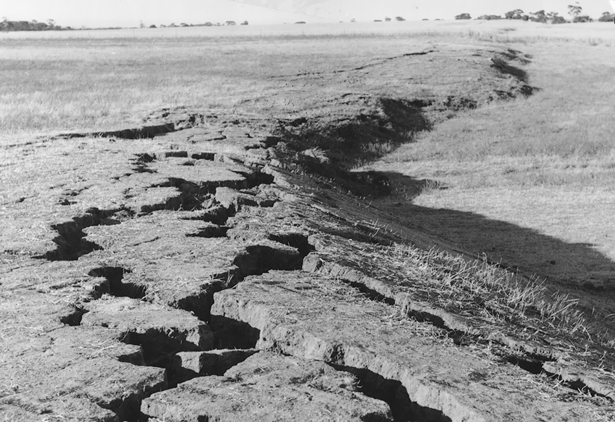
Field photograph of part of the fault scarp produced by the 14th October 1968 MW6.5 Meckering earthquake (photo credit Ian Everingham)
Why do we get earthquakes in Australia?
The Australian plate is the fastest moving continental land mass on Earth and is colliding into the Pacific plate to Australia's north and east, and the Eurasian Plate to the northwest. This generates mainly compressive stress in the interior of the Australian continent, which is slowly building up across the plate as it moves northeast about 7 cm per year. Australia's earthquakes are caused by the sudden release of this stress when rocks deep underground break and move along a fault line. While some parts of the country are more likely to experience earthquakes than others, large earthquakes can occur anywhere across the continent, and without warning.
On average 100 earthquakes of magnitude 3 or more are recorded in Australia each year. Earthquakes above magnitude 5.0, such as the destructive 1989 Newcastle earthquake, occur on average every one-to-two years. About every ten years Australia experiences a potentially damaging earthquake of magnitude 6.0 or more such as the magnitude 6.5 Meckering earthquake in October 1968.
What is Geoscience Australia's role in reducing risk to Australians from earthquakes?
We provide earthquake risk information to help Australians understand the consequences of earthquakes, which contributes to more resilient communities now and in the future. Our capability spans the earthquake value chain from observations to 24-hour monitoring and alerting, to national hazard and impact.
We collaborates with a range of stakeholders in Australia and through Australia’s overseas aid program to apply this value chain to develop actionable earthquake risk data and information to support evidence-based decisions for disaster risk reduction.
We do this by:
- developing nationally consistent data, information and advice to enable informed decisions on preparedness and response to the impact of earthquakes
- advancing our understanding of Australia’s earthquake hazard and vulnerability of the built environment to support mitigation and reduce the cost of disasters
- providing ongoing real-time monitoring, analysis and advice on significant earthquakes and potentially tsunamigenic earthquakes to help safeguard Australian and Indian Ocean communities.
To learn more about our work, access our latest data or hazard assessment tools, visit the Community Safety page.
How do we record earthquakes?
We monitor, analyze and report on significant earthquakes to alert the Australian Government, State and Territory Governments and the public about earthquakes in Australia and overseas.
Earthquakes are detected by scientific instruments called seismometers. The word seismo originates from the Greek word seismos which means to shake or move violently and was later applied to the science and equipment associated with earthquakes. Seismographs, such as the Teledyne Geotech Helicorder, were used in the past to detect earthquake activity and relied on a mechanical system to record the seismic energy in the Earth onto paper. In contrast, modern seismometers such as the raspberry shake (pictured) detect and convert any small movement in the Earth into an electrical signal for use in computer systems, as shown in the digital seismogram image of seven seismic sensors which detected the magnitude 5.4 earthquake near Moe in Victoria on 19 June 2012.
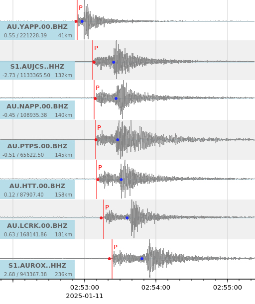
Digital seismogram image of seven seismic sensors which detected the Mw 7.2 earthquake in the Banda Sea on 24th June 2019. The tremors from this earthquake were felt in Darwin.
Determining the location of an earthquake
The accurate locations of seismometers are stored in a database accessible by an earthquake monitoring computer system. The system also has access to crustal velocity models which provide approximate information on how fast the various earthquake waves travel through the different layers which make up the Earth in the area between the earthquake and the seismometers. The times at which the differing seismic waves arrive at various seismometers are identified by Seismic Analysts or by a computer system. The arrival times of the seismic waves at the seismometers, together with the locations of the seismometers and the speed at which the seismic waves travel to the seismometers are all used to determine the location of the earthquake. This location is also known as its focus or hypocentre which is represented by the latitude, longitude and depth below the surface.
How does Geoscience Australia monitor earthquakes?
We monitor seismic data from more than 150 locations in Australia and in excess of 500 stations worldwide in near real-time, 24 hours a day, seven days a week. Data are delivered within 30 seconds of being recorded at the seismometer to our central processing facility in Canberra through various digital satellite and broadband communication systems.
Seismic data are also provided by overseas Governments which have national seismic networks. We use data provided by the Governments of New Zealand, Indonesia, Malaysia, Singapore and China and has access to data from global seismic networks provided by the USA, Japan, Germany and France. The Comprehensive Nuclear Test Ban Treaty Organisation’s International Monitoring System also provides seismic data for tsunami warning purposes.
The seismic data are collected and analysed automatically and immediately reviewed by our Duty Seismologists.
As part of the Joint Australian Tsunami Warning Centre (JATWC), Duty Seismologists are also responsible for analysing and reporting within 10 minutes of the origin time of earthquakes which have the potential to generate a tsunami. An earthquake alert is then sent to our partner in the JATWC, the Australian Bureau of Meteorology, to determine tsunami advice and publish tsunami bulletins.
The parameters of all other earthquakes with a magnitude greater than 3.5 are generally computed within 20 minutes. The analysis includes an earthquake’s magnitude, origin time and date of the earthquake and the location of its hypocentre. Smaller earthquakes that are not detected by many seismometers are difficult to locate in real-time and, consequently, are located by Seismic Analysts during normal business hours.
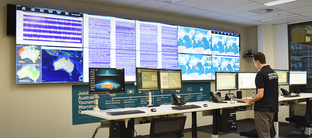
Geoscience Australia's National Earthquake Alerts Centre
What are the impacts of earthquakes?
The amplitude of the shaking caused by an earthquake depends on many factors, such as the magnitude, distance from the epicentre, depth of focus, topography and the local ground conditions.
In Australia, earthquakes with magnitudes of less than 3.5 seldom cause damage, and the smallest magnitude earthquake known to have caused fatalities is the magnitude Mw 5.4 (ML5.6) Newcastle earthquake in 1989. However, magnitude 4.0 earthquakes occasionally topple chimneys or result in other damage which could potentially cause injuries or fatalities.
Apart from causing shaking, earthquakes of magnitude 4.0 or greater can also trigger landslides, which can cause casualties. The larger the magnitude of the earthquake, the bigger the area over which landslides may occur.
In areas underlain by water-saturated sediments, large earthquakes, usually magnitude 6.0 or greater, may cause liquefaction. The shaking causes the wet sediment to become quicksand and flow. Subsidence from this can cause buildings to topple, and the sediment might erupt at the surface from craters and fountains.
Undersea earthquakes can cause a tsunami, or a series of waves which can cross an ocean and cause extensive damage to coastal regions.
The destruction from strong earthquake shaking can be worsened by fires caused by downed power lines and ruptured gas mains.
Earthquake effects, based on human observation, are rated using the Modified Mercalli (MM) intensity scale, which ranges from I (imperceptible) up to XII (total destruction) (see table below).
The Modified Mercalli Intensity (MMI) scale
| Intensity | Shaking | Description/Damage |
|---|---|---|
| I | Not felt | Not felt except by a very few under especially favorable conditions. |
| II | Weak | Felt only by a few persons at rest,especially on upper floors of buildings. |
| III | Weak | Felt quite noticeably by persons indoors, especially on upper floors of buildings. Many people do not recognize it as an earthquake. Standing motor cars may rock slightly. Vibrations similar to the passing of a truck. Duration estimated. |
| IV | Light | Felt indoors by many, outdoors by few during the day. At night, some awakened. Dishes, windows, doors disturbed; walls make cracking sound. Sensation like heavy truck striking building. Standing motor cars rocked noticeably. |
| V | Moderate | Felt by nearly everyone; many awakened. Some dishes, windows broken. Unstable objects overturned. Pendulum clocks may stop. |
| VI | Strong | Felt by all, many frightened. Some heavy furniture moved; a few instances of fallen plaster. Damage slight. |
| VII | Very strong | Damage negligible in buildings of good design and construction; slight to moderate in well-built ordinary structures; considerable damage in poorly built or badly designed structures; some chimneys broken. |
| VIII | Severe | Damage slight in specially designed structures; considerable damage in ordinary substantial buildings with partial collapse. Damage great in poorly built structures. Fall of chimneys, factory stacks, columns, monuments, walls. Heavy furniture overturned. |
| IX | Violent | Damage considerable in specially designed structures; well-designed frame structures thrown out of plumb. Damage great in substantial buildings, with partial collapse. Buildings shifted off foundations. |
| X | Extreme | Some well-built wooden structures destroyed; most masonry and frame structures destroyed with foundations. Rails bent. |
Source: Replicated from the USGS
Magnitude vs Intensity
- Earthquake magnitude is related to the energy released over its ruptured fault area
- The intensity of an earthquake refers to the level of ground-shaking at a given location
- Earthquake intensity decreases with increasing distance away from an earthquake
- The Modified Mercalli Intensity (MMI) scale is commonly used to describe the damage and felt effects of an earthquake at a given location
- MMI is a qualitative assessment of earthquake effects on structures and people
- Earthquake magnitude is a quantitative measure based on physical recordings made on seismometers
Revisions to the magnitudes of Australia's historical earthquakes
In 2016, Geoscience Australia revised the magnitudes of some of Australia's historical earthquakes as part of an international project to reassess the magnitude estimates of earthquakes around the globe. This project aimed to revise historic earthquake measurements to more accurately reflect their true size based on modernised measuring techniques.
As custodians of Australia's earthquake data, we updated information related to Australia's historical earthquakes, resulting in significant changes to what were previously thought to be some of Australia's largest events ever recorded. The following table represents our largest recorded earthquakes* as presented before and after the 2016 revision.
| Magnitude post-2016 revisions | Magnitude pre-2016 revisions | Location | Date |
|---|---|---|---|
| 6.6 | 6.7 | Tennant Creek, NT | 1988 |
| 6.5 | 6.9 | Meckering, WA | 1968 |
| 6.4 | 5.6 | Simpson Desert, NT | 1941 |
| 6.3 | 6.4 | Tennant Creek, NT | 1988 |
| 6.3 | 7.2 | Meeberrie, WA | 1941 |
| 6.2 | 6.3 | Collier Bay, WA. | 1997 |
| 6.2 | 6.3 | Tennant Creek, NT | 1988 |
| 6.1 | 6.2 | Cadoux, WA | 1979 |
| 6.1 | N/A | Petermann Ranges, NT | 2016 |
| 6.0 | 6.0 | West of Lake Mackay, WA | 1970 |
* The earthquakes listed above have epicentres on the Australian mainland or adjacent to the Australian coast.
The International Seismological Centre led this project which reassessed the location and magnitude of approximately 20 000 historical earthquakes worldwide as part of an effort to extend and improve their database of seismic events.
To learn more about our work, access our latest data or hazard assessment tools, visit the Community Safety page.