News Advancing our understanding of the Great Artesian Basin
Page last updated:22 December 2022
The Great Artesian Basin (GAB) is Australia's most significant hydrogeological system.
Covering more than 1.7 million square kilometres, it is Australia’s largest groundwater basin, underlying parts of Queensland, New South Wales, South Australia and the Northern Territory.
If the GAB was a country, it would be the 17th largest in the world, ahead of Iran, Mongolia and Peru.
Or if football fields are your preferred unit of measurement, the GAB would be equivalent to more than 300 million of them.
But it’s not just the GAB’s size which makes it so impressive.
Groundwater from the GAB is a vital resource for pastoral, agricultural and other industries as well as for more than 120 towns' water supplies, supporting at least $12.8 billion in annual economic activity according to a report by Frontier Economics.
It also supports significant cultural values for First Nations peoples and sustains a range of groundwater-dependent ecosystems, including iconic mound springs across central Australia.
Due to the sheer size and complexity of the basin it has been the focus of many studies over recent years that were aimed to better understand elements of the GAB and its groundwater resources, from a whole-of-basin perspective.
Taking this thirst for groundwater understanding a step further, Geoscience Australia recently completed a three-year project, from 2019-2022, called ‘Assessing the status of groundwater of the Great Artesian Basin’.
This project was funded by the Australian Government through the former National Water Infrastructure Development Fund and was completed in collaboration with National Water Grid Authority, Department of Climate Change, Energy, the Environment and Water, Bureau of Meteorology, Australian National University, CSIRO and various Qld, SA, NSW and NT agencies.
A basin-wide understanding
Geoscience Australia hydrogeologist Tim Ransley said that this project aimed to assess existing and new geoscientific data and technologies, including satellite data, to improve our understanding of the hydrogeological system and water balance in the Great Artesian Basin.
“The results from this project and the many studies undertaken within it have provided a more holistic understanding of the basin allowing hydrogeologists to identify knowledge gaps and make recommendations for future work within the GAB, including how to support future resource planning,” Mr Ransley said.
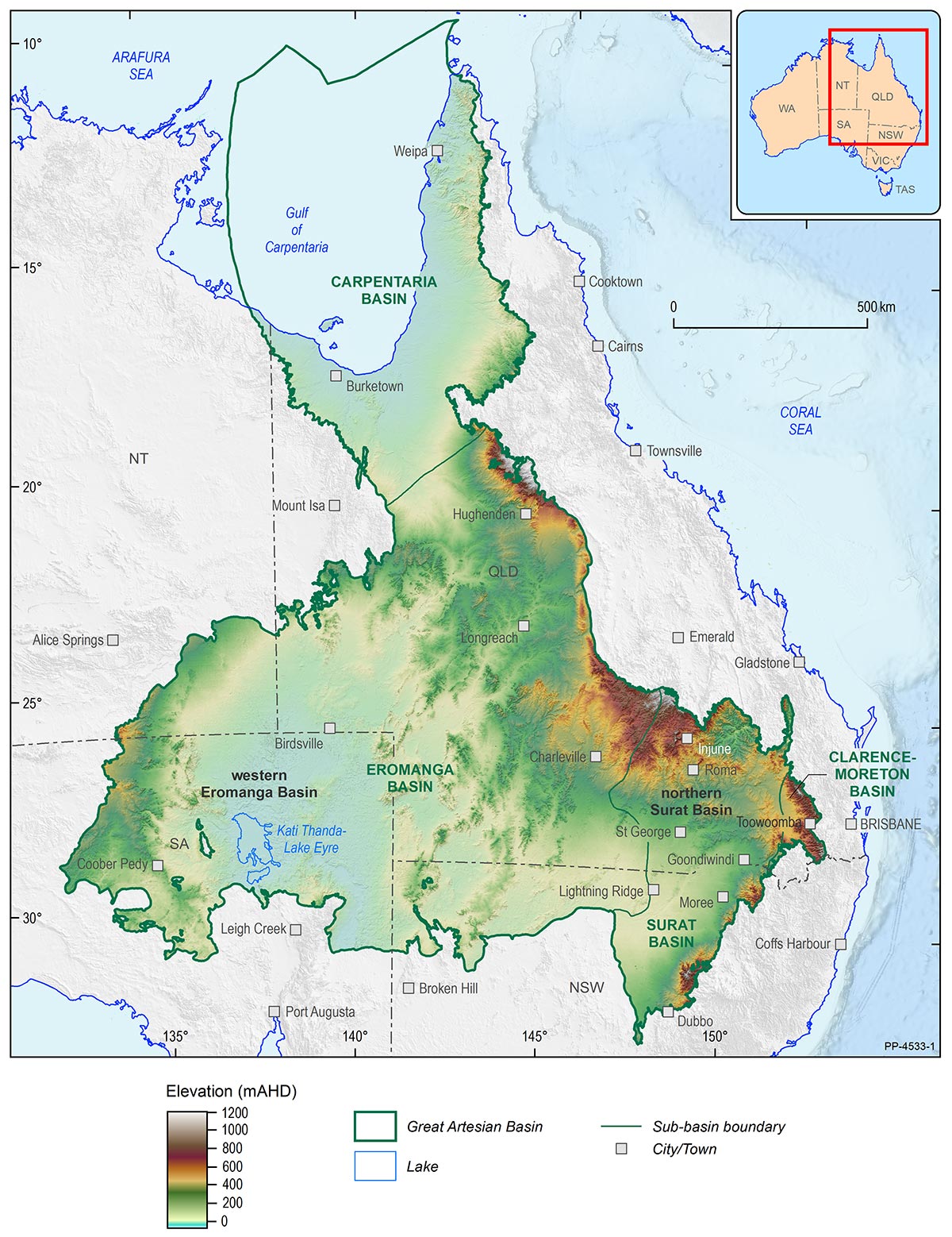
Location of northern Surat Basin and western Eromanga Basin pilot study areas within the Great Artesian Basin
During this assessment hydrogeologists used both traditional and novel approaches to try and achieve a whole-of-basin understanding.
One of the major outputs produced from these approaches is a new three-dimensional hydrogeological model, showing the basin’s architecture and highlighting the structure of its major aquifers and aquitards, as well as their stratigraphic and structural variability at a whole-of-GAB scale.
Using a compilation of data and a hydrogeological framework, Geoscience Australia’s geoscientists have created this new three-dimensional view of the GAB and believe that it will help inform future groundwater assessments and provide a base that can be built upon by future research.
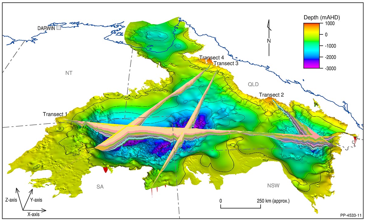
The project has developed a basin-wide geological and hydrogeological framework and produced a new three-dimensional hydrogeological model of the GAB, which is foundational to assessing the status of groundwater resources across the Basin
“Produced from a combination of updated hydrogeological surfaces, new Airborne Electromagnetic (AEM) interpretations and updated groundwater recharge rates, this 3D model of the GAB is foundational for the future assessment of the status of groundwater resources across the basin,” Mr Ransley said.
“This updated conceptualisation, alongside previous conceptualisations that have been revised, brings together significant changes to the current understanding of groundwater recharge processes in the GAB and shows groundwater flow more broadly.
“It has provided a clearer picture of the basin and its hydrogeological systems, which will support improved resource management and will also allow us to pinpoint certain locations of interest for further research.”
While this 3D model may be the foundation for future assessments, Geoscience Australia has also assessed the tools that might be capable of building upon it.
The science behind the assessment
Traditional on-ground monitoring systems, including groundwater level and pressure monitoring, are vital for providing accurate and current groundwater resource data, such as storage volume and level estimates.
While these traditional tools are currently the main method for monitoring groundwater resources, other tools such as satellite technologies are starting to be explored and assessed to see if satellites can be used to support traditional on-ground groundwater monitoring.
A new approach explored in this Great Artesian Basin project was the use of data collected by the Gravity Recovery and Climate Experiment (GRACE) satellite.
The 14-year GRACE satellite mission, between NASA and the German Aerospace Center which concluded in 2017, measured changes in the local pull of gravity as water shifts around the Earth due to changing seasons, weather and climate processes.
Even though this initial mission ended in 2017, the GRACE Follow-On (GRACE-FO) mission was launched in 2018 to continue tracking Earths water movement across the planet, which was also used for this assessment.
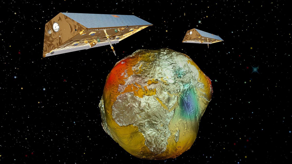
GRACE, twin satellites launched in March 2002, make detailed measurements of Earth's gravity field. Source: Astrium/GFZ
“GRACE satellite observations are a promising tool capable of remotely monitoring confined groundwater storage changes at a whole of basin scale over months, years or decades, and using this tool could be a step towards remote groundwater monitoring to compliment on-ground measurements” Mr Ransley said.
Yet while GRACE shows promise, Mr Ransley reiterated that it still relies on traditional monitoring methods.
“Despite its potential, further work is needed to operationalise the GRACE as a tool before it could be integrated into current monitoring programs,” Mr Ransley said.
“On-ground groundwater level and pressure monitoring remain an essential tool for managing groundwater resources in the basin and data from satellites such as GRACE will complement and strengthen these on-ground tools.”
With the reliance of groundwater expected to increase due to varying factors, the evolution of both traditional and novel monitoring techniques and technologies such as these will be key in supporting future policy and groundwater management across Australia.
Groundwater in Australia: How this assessment can support policy and groundwater management
Outputs from the ‘Assessing the status of groundwater in the Great Artesian Basin’ project will support the Great Artesian Basin Strategic Management Plan, which will provide a framework to help guide water policy and resource planning for governments, First Nations Peoples and other water users that are dependent on the basin.
“Australia’s dependency on groundwater for economic, environmental and social wellbeing means it is important that assessments like these continue to be done,” Mr Ransley said.
“Through these assessments, government and industry can create and update groundwater management plans to help secure Australia’s valuable water resources.”