Assessing the status of groundwater in the Great Artesian Basin
Page last updated:24 January 2023
Project started 2019 and completed 2022
Background
Groundwater from the Great Artesian Basin (GAB) is a vital resource for pastoral, agricultural and extractive industries as well as for town water supplies, supporting at least $12.8 billion in economic activity annually (Frontier Economics 2016). It is an essential resource that supports cultural values for First Nations peoples and sustains a range of groundwater dependent ecosystems.
Increasing and competing demands for water to support new or expanding industries, communities and the environment, as well as the complex nature of GAB aquifers, are key challenges for the long-term management of the basin’s groundwater resources. Although considerable research has previously been undertaken to improve understanding of the GAB groundwater system, there remain major hydrogeological knowledge gaps that limit the management of groundwater resources in the Basin.
The Australian Government, through offsets from the former National Water Infrastructure Fund, commissioned Geoscience Australia to undertake the project ‘Assessing the Status of Groundwater in the Great Artesian Basin’. The project commenced in July 2019 and finished in December 2022.
Objectives
The overall aim of this project was to assess existing and new geoscientific data and technologies to improve understanding of the hydrogeological system and water balance in the GAB to inform water management decision-making within the basin.
Objectives were to:
- Increase information accessibility by providing inventories of existing data and undertaking new data acquisition and processing.
- Improve the groundwater system understanding by updating the hydrogeological framework and groundwater recharge estimates and assessing the new understanding on whole of basin water balance estimates.
- Assess new geoscientific data and technologies, including spatial and temporal satellite data, to estimate groundwater storage changes over-time and evaluate these with hydrogeological observations.
- Identify data and knowledge gaps for future work.
Outcomes
- Consistent basin-wide data and information for understanding groundwater systems.
- New mapping of aquifer/aquitard geometry and properties.
- Revised estimates of groundwater recharge and uncertainty.
- Assessed a basin-wide water balance incorporating associated uncertainty estimates.
- Assessed new techniques, including satellites data, for future monitoring of groundwater.
- Identified data and knowledge gaps for future work.
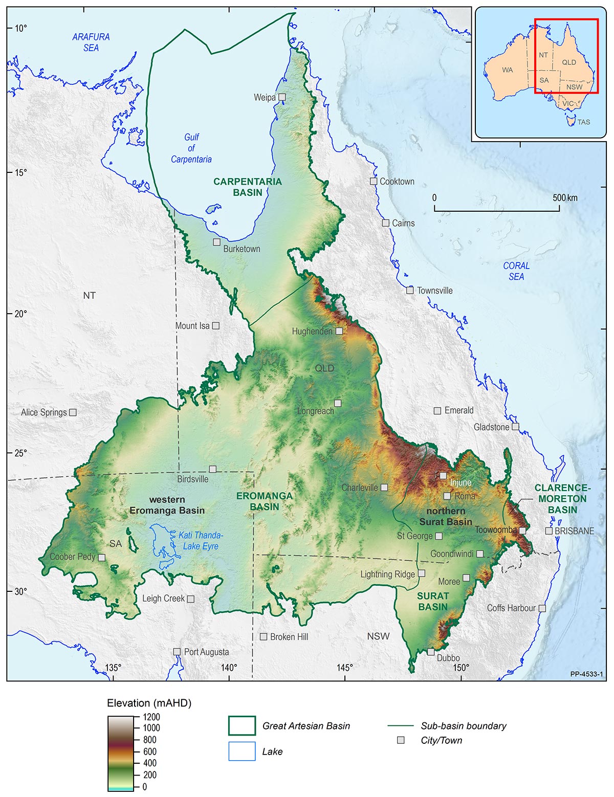
Location of northern Surat Basin and western Eromanga Basin pilot study areas within the Great Artesian Basin
Outputs
The following reports are available:
Project summary
Technical reports:
Hydrogeology
- Geological and hydrogeological architecture of the Great Artesian Basin – A framework to develop hydrogeological conceptualisations
- Great Artesian Basin geological and hydrogeological surfaces update
- Regional stratigraphic correlation transects across the Great Artesian Basin - Eromanga and Surat basins focus study
- Palynological data review of selected wells and new sampling results in the Great Artesian Basin
- Improving hydrogeological conceptualisations of the Great Artesian Basin: Northern Surat Basin pilot study – methods and preliminary results
Groundwater recharge
- Great Artesian Basin, Queensland, Airborne Electromagnetic Survey: SkyTEM® electromagnetic data and laterally constrained inversion conductivity estimates
- Great Artesian Basin eastern recharge area assessment: Eastern Eromanga Basin airborne electromagnetic data interpretation report
- Great Artesian Basin eastern recharge area assessment: Northern Surat Basin regional airborne electromagnetic survey interpretation report
- Quantifying diffuse recharge to the Great Artesian Basin groundwater system
- Assessing recharge processes and flow dynamics using environmental tracers in the Great Artesian Basin
Water balance
Assessing new tools
- Interpreting time-varying gravity data to assess groundwater storage change in the Great Artesian Basin
- Monitoring groundwater in the Great Artesian Basin through remote sensing: the Surat Basin
- Monitoring groundwater in the Great Artesian Basin through remote sensing: data assimilation over the Surat and Eromanga Basins
- Groundwater estimates in the Great Artesian Basin (2018-2020) from the analysis of GRACE Follow-On data - A report completed for Geoscience Australia
- Ground surface movement in the northern Surat Basin derived from campaign GPS measurements
- InSAR processing over the Great Artesian Basin and analysis over the western Eromanga Basin and northern Surat Basin
- Bayesian inferences on groundwater flow within the Great Artesian Basin
Collaboration
Geoscience Australia undertook this assessment in partnership with:
- Australian Government Department of Agriculture, Water and the Environment (now the Department of Climate Change, Energy, the Environment and Water)
- National Water Grid Authority
- Queensland Office of Groundwater Impact Assessment
- Queensland Department of Regional Development, Manufacturing and Water
- South Australian Department for Environment and Water
- NSW Department of Planning and Environment
- NT Department of Environment, Parks and Water Security
- Bureau of Meteorology
- The Australian National University and
- The Commonwealth Scientific and Industrial Research Organisation (CSIRO).
For further project information please contact: GABSecretariat@ga.gov.au
References
Frontier Economics. 2016, Economic output of groundwater dependent sectors in the Great Artesian Basin – A report commissioned by the Australian Government and Great Artesian Basin Jurisdictions based on advice from the Great Artesian Basin Coordinating committee.