News
Using the power of Landsat and Digital Earth tools to understand coastlines in Australia and Africa
Published:28 September 2023
How leading-edge Landsat based Earth observation products and tools are helping us to understand Africa’s and Australia’s coastlines
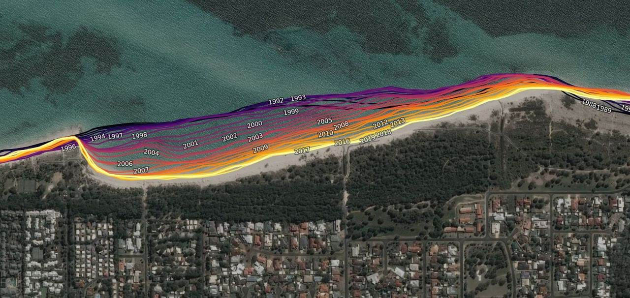
DEA Coastlines - 1988-2019 - Busselton, Western Australia - Visualisation of 32 years of coastal erosion using DEA Coastlines data
The stability of the world's coastlines is critical. According to the Australian Bureau of Statistics, in 2019 more than 87% of Australia’s population lived within 50 km of the coast, and more than 30 of Africa’s countries are coastal. From sloping, sandy beaches to craggy cliffs, coastlines play host to thousands of species and provide an economic boost to local communities through tourism and water activities like fishing. Coastlines are dynamic, and changes are driven by many factors including ocean currents, wind patterns, extreme weather and coastal development. Understanding how coasts change over time is crucial to supporting local communities and maintaining biodiversity all over the world.
For more than five decades, continental land surface and coastline images have been captured by Landsat satellites, recording a wide range of information about land and water resources. These images are a rich source of information for scientists and land managers, but can be difficult to utilise in a timely, cost-effective manner. Recent advances in computing have made the Landsat archive more accessible and easier to analyse by reducing the amount of time users spend on data processing for time-series analysis. Digital Earth Australia and Digital Earth Africa have transformed access for users by providing free, updated, continental-scale information with a long time series of decision-ready information.
Analysis Ready Data (ARD) is a key underpinning technology that allows users to successfully conduct large-scale Earth observation analyses. Converting the original satellite imagery to ARD involves a series of corrections for atmospheric conditions, topographic shape, solar angle, ground cover, and the addition of cloud and shadow masking. The resulting data is spatially and temporally consistent, which allows scientific workflows to be applied consistently at any location throughout the history of the satellite record - ultimately leading to better outcomes. Through cloud storage and processing, ARD can then be automatically analysed across continents and create outputs that can be used to help monitor and manage coastlines around the world.
Digital Earth Australia Coastlines (DEA Coastlines) is a leading-edge coastline mapping service, developed through Geoscience Australia. It combines U.S. Geological Survey (USGS) Landsat satellite data and tidal modelling to map over 30,000 km of Australia’s dynamic coastline with annual data spanning back to 1988.
Digital Earth Australia Intertidal Elevation (DEA Intertidal Elevation) maps Australia’s intertidal zone - the area between the highest and lowest tide marks - in 3D. This helps to understand the extent and elevation of Australia’s sandy beaches, tidal flats, rocky shores, and reefs.
Together, DEA Coastlines and DEA Intertidal Elevation offer a detailed picture of Australia’s coastline.
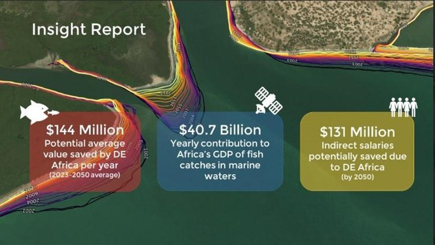
Image from: Digital Earth Africa Cost to Coasts Insight Report
Sharing knowledge and innovation across the globe has helped Digital Earth Africa leverage the methods used to develop the DEA Coastlines product to inform the development of an Africa-focused service. Thanks to funding from the Australian Government Department of Foreign Affairs and Trade, Digital Earth Africa Coastlines (DE Africa Coastlines) was launched in 2022. It was developed and validated with Africa-based partners, who were able to tailor the service to support country-led decision making on coastal management across the continent. Thanks to this shared innovation, Digital Earth Africa has the potential to inject over US580 million per year into Africa’s economy and change the lives of 270 million people by mitigating coastal erosion risks in the agriculture, fisheries, real estate and insurance sectors.
Planning for future coastal change
Coastal erosion is closely linked to a changing climate, as the erosion of beaches and shorelines is impacted by rising sea levels, changing precipitation patterns, and higher temperatures. When combined with the impacts of increasing human development, coastal erosion has the potential to cause significant changes to the coastlines of Australia and Africa. The significance of coastal erosion is highlighted by the UN’s Sustainable Development Goals – particularly UNSDG 15, which emphasises the global priority to ‘protect, restore and promote the sustainable use of terrestrial ecosystems’ including coastal zones.
With a changing climate, increasing extreme weather events are already impacting coastal communities. Using Earth observation data and products such as DEA Coastlines, DEA Intertidal Elevation, and DE Africa Coastlines, decisionmakers, researchers and industry can better understand our coastal environments and identify patterns of coastline change. These insights can be used to make data-informed decisions to prevent risk to communities, delicate ecosystems, and critical infrastructure.
Data-informed decision making
Gladstone, Queensland, Australia
In Gladstone, Queensland, Boyne Island and Tannum Sands beaches hold significant value to the local communities, visitors, and First Nations peoples. It is estimated that both beaches have significant drift of sand to the north, with a combined estimated shift of 8,000 to 68,500 m3/year. Using DEA Coastlines, JB Pacific undertook a preliminary assessment of shoreline movements to understand the historical shoreline position and inform the recommendations of a Shoreline Erosion Management Plan. The decades of data available through DEA Coastlines informed recommendations on how to best manage local shoreline recession and migration. These recommendations are now part of the Gladstone Regional Council’s Erosion Management Plan which aims to proactively plan for erosion management of the local coastline.
Saint-Louis, Senegal
In Senegal, seaside communities are feeling the impact that climate change is having on how and where they live. In one example, the coastal town of Saint-Louis, in particular, is experiencing rapid erosion of its coastline. Coastal erosion is further compounded by high tides flooding the streets and destroying schools and homes. Flooding has forced the relocation of over 300 families from their homes to UN-funded local camps set up to help internally displaced people. Local decision-makers use DE Africa to identify patterns in changes to their coastline. This insight is used to make informed decisions for communities, such as developing long-term housing options that will withstand the changing coastline.
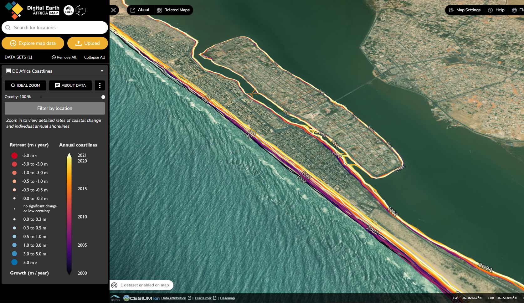
Annual coastline change in Saint-Louis, Senegal as demonstrated by DE Africa Coastlines
It [DE Africa Coastlines] makes it possible to monitor various indicators in relation to coastal risks…the advantage is that these lower resolution images are easily accessible, are free, while high resolution images are expensive and not necessarily accessible. And as part of the work we want to do on a long-term regional scale, it is much more advantageous to be able to access free images in order to be able to practice this monitoring of long-term indicators.
Dr Moussa Sall, Centre de Suivi Ecologique
Find out more about DE Africa Coastlines and its application in Senegal in this video.
Data-informed insurance
Australia
The Insurance Council of Australia (ICA) has recommended the use of DEA Coastlines as a fundamental data source to assess and understand the risk of coastline change to infrastructure and assets across the country. The ICA recognises that climate change is driving rising sea levels and exacerbating coastal hazards, putting communities, property and critical infrastructure at risk. It also recognises that it may make properties uninhabitable. Using Earth observation products and tools such as DEA Coastlines will enable the insurance industry to make informed assessments of the risk to these assets and identify opportunities for decision-makers and industry to adapt and protect the infrastructure - ultimately making insurance more affordable.
Africa
In Africa, the estimated penetration rate of general insurance (including property, health and asset-based insurance) was only 1.8%, compared to the global average of 3.3% in 2020. Earth observation products and tools such as DE Africa Coastlines open up a market in Africa to make informed insurance risk assessments. Insurance companies can use data to be more informed and confident to insure coastal assets, more effectively calculate premiums, and assess claims. It is estimated that DE Africa‘s products and tools could generate US$54 million per year in additional profits for the insurance sector. The additional revenue estimated at industry level could also lead to the creation of 4,500 new direct jobs and around 9,000 indirect ones in Africa, resulting in US$56 million and US$105 million in salaries, respectively.
Learn more about the potential of DE Africa Coastlines in the Insight Report – Cost to Coasts
Learning from the past: assessing the impact of coastal management actions
Gold Coast, Australia
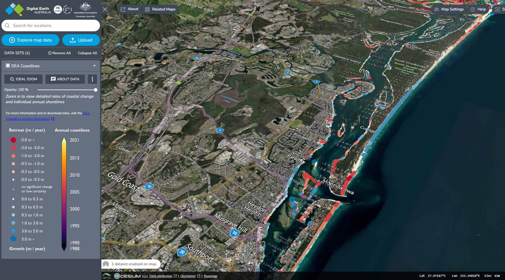
Coast annual coastline change (m/year) using DEA Coastlines
The City of Gold Coast Council and Griffith University have used DEA Coastlines tools and notebooks on the DEA Sandbox to quantify and describe the effects of coastal management actions at South Stradbroke Island. In 1986, the migrating and dynamic entrance to the Nerang River was stabilised with training walls and an artificial sand-bypassing system was established to maintain the natural flow of sand to South Stradbroke Island. After the introduction of the sand-bypassing system, the southern shorelines of the island were seen to adjust and stabilise over the next three decades. The study from City of Gold Coast Council and Griffith University found the current sand-bypassing operations continue to maintain the natural flow of sand to South Stradbroke Island to this day, with no obvious mid- to long-term effects on shoreline position. The team hope the insights gained from using DEA Coastlines will be used to inform future coastal management interventions planned for the region in 2023 and beyond.
Saly Portudal, Senegal
The coastline of Senegal is an important source of economic and cultural resources, providing local communities with important opportunities for employment in the tourism and fishing industries. The Centre de Suivi Ecologique (CSE) used DE Africa Coastlines to assess the changing coastline at the seaside resort of Saly Portudal, where it has been estimated that the coastline has eroded between 0.7 and 5 metres in some areas between 1946 to 2001 . In an attempt to stop the beach erosion, breakwaters and other infrastructure were added to protect the coastline. These interventions were found by CSE to be unsuitable and created record loss of sand at 1 metre per year. In 2020, new breakwaters were added to prevent further drastic sand movement in the area. Using tools from DE Africa Sandbox, the CSE team assessed the coastal erosion along this stretch of coastline. Currently the breakwaters are successful in protecting beaches at the hotels whilst areas not protected are seeing beach erosion at approximately 3 metres per year.
Learn more about the impact of DE Africa Coastlines on communities in Africa here
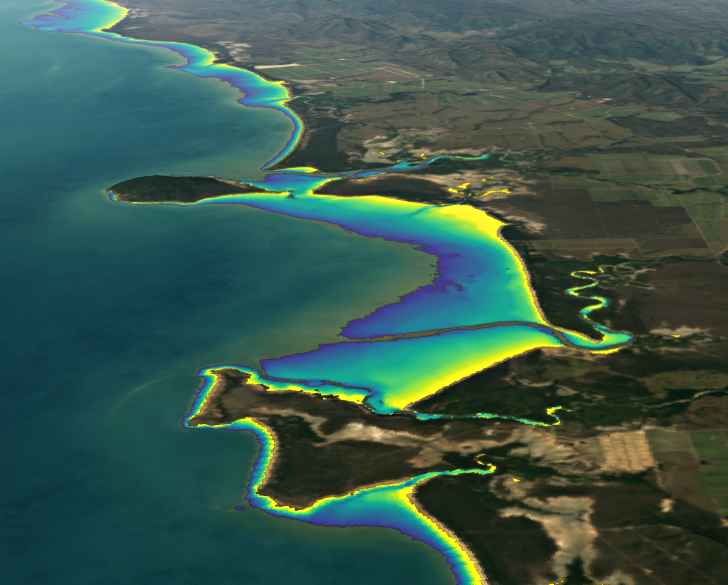
DEA Intertidal Elevation (NIDEM) - 1987-2018 - Mackay Queensland
Protecting our reef - Queensland, Australia
The seashore with its dancing tides has long held a special place in human’s imagination. Thanks to the moon, sun and gravity, this place where land meets sea is not a fixed point, but a region between low and high tides — the intertidal zone.
Laura E.O. Rocchio
The intertidal zone is the area between the highest tide mark and the lowest. DEA Intertidal Elevation helps us to understand some of the most vulnerable ecosystems through maps in 3D that show the depth (elevation) of Australia’s beaches, tidal flats, rocky shores, and reefs. This information helps us understand how the intertidal region changes due to tide. This data, complemented by the longer-term changes identified using DEA Coastlines, can be used to provide a highly accurate picture to inform decision-making and planning. Dr Robin Beaman from James Cook University used DEA Intertidal Elevation as a key data source to develop the Great Barrier Reef, Torres Strait, and Northern Australia 30m Bathymetry grid products. These products provide a crucial link and consistent elevation data in the transition between the ocean and the land, enabling improved modelling and decision making in the coastal zone for applications such as risk assessment and habitat management.
Learn more about DEA Intertidal Elevation here
How to get involved
An introduction to the DEA Coastlines product can be accessed through the DEA Maps platform, which interactively steps through the product: https://maps.dea.ga.gov.au/story/DEACoastlines
More information about the Digital Earth Australia and Digital Earth Africa programs can be found via their websites.
- Digital Earth Australia - https://www.dea.ga.gov.au
- Digital Earth Africa - https://www.digitalearthafrica.org
For map-based access to DEA Coastlines, DE Africa Coastlines and DEA Intertidal Elevation services, as well as many other Landsat-based services, check out Digital Earth Australia Maps and Digital Earth Africa Map.
All DE Australia and DE Africa services can also be accessed through the free learning and analysis environments provided by the DE Australia Sandbox and DE Africa Sandboxes. The Sandboxes include sample data and Jupyter Notebooks that allow you to experiment with DE Australia’s and DE Africa’s Earth observation datasets and explore proof-of-concept applications.
Visit https://app.sandbox.dea.ga.gov.au or https://sandbox.digitalearth.africa to sign up for a new account.
About Landsat
Since 1972, Landsat satellites have continuously acquired images of the Earth’s land surfaces, surface waters, and coastal regions, providing uninterrupted data to help land managers and policymakers make informed decisions about natural resources and the environment. The mission is jointly managed by the USGS and NASA. Data acquired by Landsat satellites are distributed from the USGS Earth Resources Observation and Science (EROS) Center in Sioux Falls, South Dakota.
Learn more about Landsat at https://www.usgs.gov/landsat and https://landsat.gsfc.nasa.gov
Learn more about Landsat Products at https://www.usgs.gov/landsat-missions/landsat-science-products