News
A true partnership to improve position, navigation and timing services in Australia
Published:17 July 2023
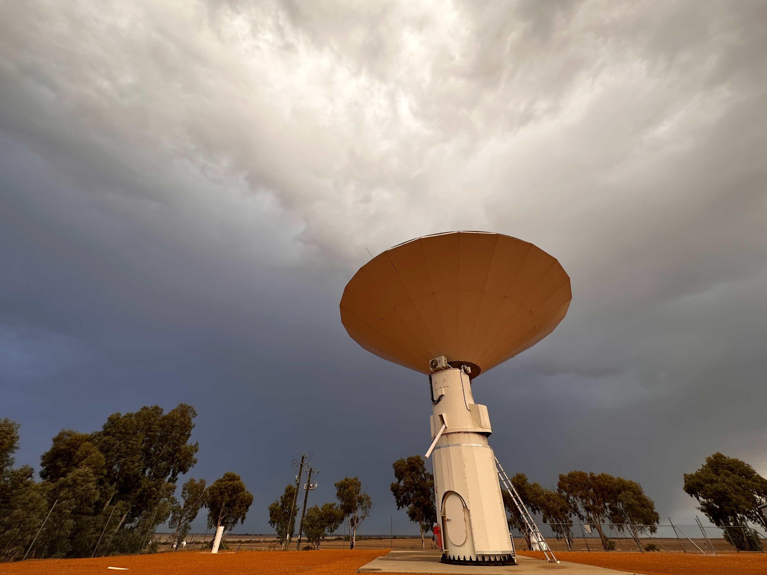
The 12 m Patriot Antenna used for Very Long Baseline Interferometry observations at the Yarragadee Geodetic Observatory. Credit: Robert Nugent Geoscience Australia Artist in Residence 2023
What do precision agriculture, weather predictions and synchronising financial transactions all have in common? They rely on geodesy, the science of measuring the Earth that enables all Positioning, Navigation and Timing (PNT) applications that are used in everyday life.
This exact science underpins the global geospatial economy, which has a value of at least US$1 trillion per year and is arguably the most important economic and technological development since the internet. And it is still accelerating.
Understanding how fast the Earth is spinning and the tilt of its axis is vital for multiple applications in our modern life, such as ~3 billion smartphone applications, disaster modelling, navigation assistance for the blind and the operation of our power grids.
But how do we record the spin rate and axis tilt of the ever-wobbling Earth at any specific point in time? And why is it vital for PNT applications?
There are many techniques that geodesists use to observe the Earth, but the only one that provides answers to these questions is Very Long Baseline Interferometry (VLBI).
What is Very Long Baseline Interferometry?
VLBI is a fundamental geodetic observation method that observes and records measurements of the Earth’s position, tilt and speed of rotation. It is the only method that does this, underlining its importance to the toolkit of geodetic techniques.
It is also the only method that measures the difference between time measured by atomic clocks onboard satellites, and mean solar time, which is important for providing synchronised time.
By using a network of radio telescopes from around the world, VLBI observes the time it takes for signals emitted from the plasma surrounding nearby supermassive black holes to reach different radio telescopes that are in different locations.
Yes, supermassive black holes.
This time difference is then used to calculate the distance between these telescopes and determine how they have moved since their last reading, informing geodesists of the Earth’s measurements at that point in time.
Geoscience Australia Director of Geodesy, Mr Nicholas Brown, explained that we need to use an external frame of reference when making measurements of the Earth’s position, tilt and speed of rotation, and that these supermassive black holes are our best indicator as they don’t really move.
“Think about standing on a roundabout at your local playground,” Nick said.
“The only way you can tell how fast you are spinning is by seeing how fast the trees fly by. These supermassive black holes are our trees.”
These measurements, called Earth Orientation Parameters, are used by Global Navigation Satellite System (GNSS) satellites to help geodesists understand the location-based relationship between the Earth’s position in space and the GNSS satellites that are in orbit.
Recognising how vital VLBI data is for everyday life, Geoscience Australia, AuScope and The University of Tasmania work together to operate three separate VLBI stations at geodetic observatories across Australia.
These observatories are located around the country at Yarragadee, Western Australia; Katherine, Northern Territory; and Hobart, Tasmania.
How does this data get processed?
Together, Geoscience Australia and the University of Tasmania operate the Australian VLBI Correlation Centre at the National Computational Infrastructure at the Australian National University.
Staff at the centre collaborate with partners from the International Association of Geodesy to convert VLBI data into the information needed by GNSS operators.
Currently, for global VLBI experiments, Australia is required to freight hard drives storing between 10 and 100 terabytes of raw VLBI data from geodetic observatories in remote parts of Australia to data centres in Washington, USA or Bonn, Germany.
This current method means one 24-hr session of VLBI observation data needs at least 14 days of lead time until the results are released. This significant delay is viewed as a bottleneck for VLBI correlation and means Australia is not as efficient as other global centres.
The impact of this is that geodesists are not able to monitor changes in the Earth as effectively, limiting the improvement of the resilience and accuracy of PNT services.
“The time difference information provided by VLBI should be delivered to the GNSS operation centres as soon as possible to help monitor and improve the orbits of their satellites,” Nick said.
“Not only that, but all space agencies also need VLBI to track orbits of all lunar and deep space missions, and numerous military applications require this information for their operations.
“Any delay with the VLBI information will affect satellite orbit predictions, causing a loss of precision to the navigation data that is distributed to PNT customers, including farmers, financial institutions, and weather observations.”
Farmers rely on positioning information as it enables tractors to be accurately guided along designated wheel tracks, maximising the cropping area and, as a result, improving yields. It also allows seeds to be sown precisely between rows, meaning inputs such as water, fertiliser and herbicide can be applied directly over the crop with less wastage.
Having an improved processing capability here in Australia is vital, as a loss of GNSS services would greatly impact the navigation, tracking and precision timing needed to allow these applications to work.
Not only that, but a global loss of GNSS services could cause both the UK and US economies to lose approximately US$1 billion per day.
So, to augment this process and strengthen Australia’s geodetic capabilities, Geoscience Australia, The University of Tasmania, AARNet and AuScope are working together to develop more accurate VLBI products for Australia.
These products will ultimately improve PNT services across the country, with the aim to improve speed of production, resilience and accuracy.
What is being done to improve these PNT services? What does this collaboration entail?
As part of this collaboration, Geoscience Australia has recently signed an agreement with AARNet to install new optic fibre connections and services at the Katherine and Yarragadee Geodetic Observatories. The Geodetic Observatory at Hobart has already been provided with optic fibre services.
AARNet provides Internet services to various education and research communities across Australia and will manage the high-speed services of this optic fibre connection once it has been implemented.
This upgrade will eliminate the need to freight raw VLBI data overseas, greatly reducing the wait time between the observation, processing and release of Australian VLBI data.
Therefore, PNT service providers and users will be able to access the most up-to-date precise positioning information through almost real-time processing, which will lead to faster developments of more accurate and reliable PNT products.
AuScope CEO Dr Tim Rawling believes that the optic fibre services provided by AARNet are the key to establishing a fully functional VLBI Global Observing System array, which will improve VLBI results for Australia and unlock access to improved PNT results at the 1mm level.
“We are very excited by the opportunities that near real-time delivery of VLBI data will create in Australia. Whilst the operational advantage is clear there will also be a huge impact for the research community who will now be able to rapidly access this critical data,” Tim said.
Some of the other benefits of this installation include:
- Improvement in the accuracy of VLBI data by one order of magnitude. This is critical to meet the Global Geodetic Observing System goals of developing a reference frame accurate to 1 mm in position and 0.1 mm/yr in velocity, which is key for applications such as monitoring climate change.
- Faster and more accurate feedback to the VLBI station operators, allowing small systematic errors or station faults to be recognised earlier.
- Strengthening of military platforms and systems, the satellite industry, aviation, shipping, logistics, many sciences, many areas of engineering (e.g., driverless vehicles, drones, intelligent grids), precision agriculture, Smart Cities, computer/cell phone ecosystems, location-based services, significant parts of Artificial Intelligence, big data analytics, and the Internet of Things.
- A full (continuous) operation of the Australian VLBI array that will allow for an improved comparison between VLBI and the satellite techniques, removing technique discrepancies in future.
- Reduced need for large storage volumes at the sites of VLBI dishes.
- Development of local expertise in all aspects of the VLBI technique, from scheduling, observation, correlation and analysis.
Geoscience Australia will continue to work with the University of Tasmania to analyse VLBI data through these newly improved stations.
“These stations form some of the most crucial geodetic infrastructure in the world, given the sparsity of VLBI infrastructure in the Southern Hemisphere,” Nick said.
“The correlation centre and optic fibre services are the last piece missing for full VLBI capability in Australia. Once active, we will be able to design and perform our own experiment series for improved results for the Australian continent and triggering development and improvements globally.”