News Satellite imagery reveals three decades of coastal change
Page last updated:14 April 2021
The evolution of Australia’s coastlines can now be seen in unprecedented scale and detail, via a new tool developed by Geoscience Australia’s Digital Earth Australia (DEA) program.
Using satellite imagery collected since 1988, DEA Coastlines maps annual changes to Australia’s coastlines to highlight long-term trends in coastal erosion and growth.
The free online tool can also illustrate how natural coastal features like sandbanks or river mouths shift and change over time.
Geoscience Australia’s National Earth and Marine Observations Branch Head Maree Wilson said DEA Coastlines provides scientists, managers, and policymakers with new information to maintain and protect Australia’s iconic shores for future generations.
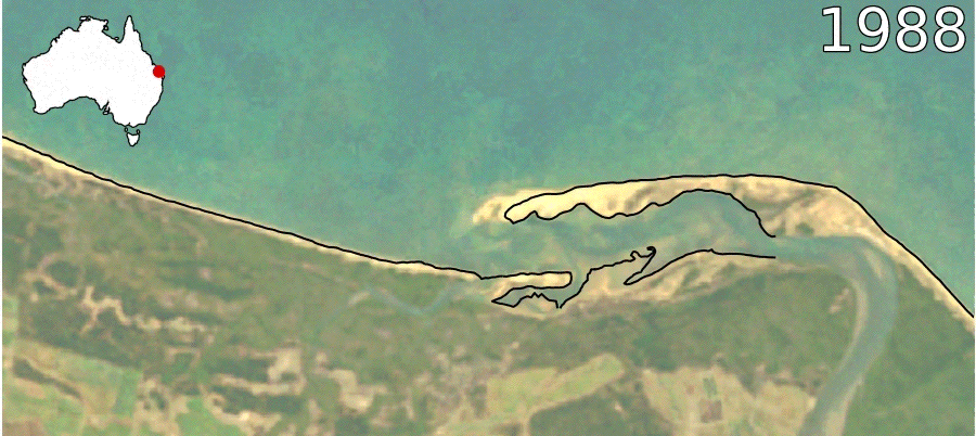
Barubbra Island, Queensland: DEA Coastlines has captured complex coastal change at the mouth of the Burnett River north of Bundaberg, including the breaching of the sand spit at Barubbra Island in 2006
“Australia has a highly dynamic coastline of over 30,000 kilometres with many unique environments: sandy beaches, rocky cliffs, muddy tidal flats, and mangroves. DEA Coastlines is the first nationally consistent dataset within Australia that tracks these changing shorelines,” Ms Wilson said.
“Understanding how our coastal environments have been historically affected by pressures such as extreme weather, sea level rise and human development is vital to managing our coastlines now and into the future."
DEA Coastlines uses world-leading techniques to combine satellite data with tidal modelling to map the location of the coastline at mean sea level each year, showing changes along our coastlines at an unprecedented scale.
The rise and fall of the tide along Australia's coast dramatically affects the position of the shoreline, making it difficult to separate long-term coastal change from the short-term effect of tide.
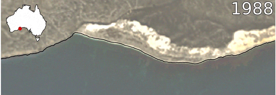
Streaky Bay, South Australia: DEA Coastlines reveals the formation of wave-shaped recurved spits at Streaky Bay in South Australia. These coastal features have extended eastwards by over 300 metres since 1988.
This is particularly the case in locations like north-west Australia's Kimberley region, where tides can rise by up to 11 metres, potentially shifting the position of the shoreline by tens or hundreds of metres.
By accounting for tide, the DEA Coastlines method produces coastlines and rates of coastal change that can be compared consistently across time, and between different coastal locations and environments along Australia's coastline.
DEA Coastlines also uses an advanced subpixel mapping method that uses subtle differences in the “wetness” of each satellite pixel to draw out high resolution coastlines from lower resolution satellite imagery.
This means the tool is accurate down to 10 metres – and able to detect coastal change as small as 2.9 metres in certain coastal locations. Previous global mapping was limited to 30-metre resolution.
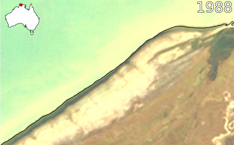
Point Stuart, Northern Territory: At Point Stuart in the southern Van Diemen Gulf, Northern Territory, DEA Coastlines reveals a continuous 100 kilometre hotspot of coastal erosion, with coastlines retreating as rapidly as 15 metres per year.
DEA Coastlines also draws on nearly 58,000 independent measurements of coastline positions across Australia to ensure the accuracy of its mapping.
“Geoscience Australia worked extensively with local councils, state governments, academia and citizen scientists to ensure the tool will help them reliably assess impacts to our precious coastlines and plan for the future,” Ms Wilson said.
Geoscience Australia’s Digital Earth Australia program puts insights from satellite data into the hands of more Australians, driving innovation for a more productive and sustainable future.
The DEA Coastlines tool is available to explore on the interactive DEA Maps platform.
Details about the tool and data downloads are available online.
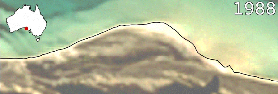
Twilight Cove, Western Australia: DEA Coastlines shows rapid coastal growth at Twilight Cove, Western Australia, starting in 1995. This has resulted in the local beach increasing in width by up to 550 metres since 1988.