Mineral potential mapper
Page last updated:22 August 2018
What is the Mineral Potential Mapper?
Geoscience Australia's Mineral Potential Mapper is a computer-based system designed to map the nation's potential for new mineral resources. This system has been applied at continental scale to ore deposits containing a combination of nickel (Ni), copper (Cu) and the platinum-group elements (PGEs). It is a decision support system for government and for the mineral exploration industry to assist in targeting new resources.
What are the problems being addressed?
(see Stage 1, Problem, in figure 1)
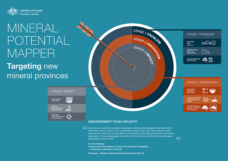
Figure 1. Targeting new mineral provinces
Demand for metals
Australia has benefited greatly from its natural endowment in mineral resources. Yet there is ever-growing demand for metals such as nickel, copper and the PGEs, whether used in everyday appliances utilising stainless steel or in high-tech gadgets or in reducing toxic emissions from vehicles. The maintenance of Australia's resource base requires replenishment through discovery of new mineral resources, so that a supply 'pipeline' of projects is ensured.
Decreasing deposit discovery
Resource replenishment is threatened by the declining rate of discovery of major new mineral resources over the past decade or so, even during periods of high exploration expenditure.
Cover impedes discovery
One of the key impediments to mineral exploration success is the blanket of sediments and weathered rock that conceals approximately 80% of Australia's prospective basement rocks. Most of the known and mined mineral deposits occur in areas of outcropping rocks or where the 'cover' is thin. But there is no reason to believe that areas of deeper cover are any less prospective than outcopping areas.
In addition to the broad problems outlined above, there are specific questions on Australia's potential for mineral deposits of Ni-Cu-PGEs. Particular types of these deposits that are hosted by igneous intrusions may be extremely large and valuable, and are well known in several other countries. The Noril'sk deposit in Russia, for example, has a value estimated at approximately $1 trillion. However, only a very small number of medium to small sized deposits of this general kind are presently known in Australia. Given Australia's favourable geology, Geoscience Australia holds the view that potential exists for discovery of new, very large, intrusion-hosted Ni-Cu-PGE deposits.
How has Geoscience Australia addressed these problems?
These important issues call for innovative solutions to increase the discovery rate, as recognised in the federal and state government-endorsed National Mineral Exploration Strategy and the UNCOVER initiative. Geoscience Australia has a key role in assessing not only the nation's inventory of known mineral resources, but also in advising industry and government on the potential for as-yet undiscovered resources. Understanding this potential requires knowledge of the continent's geology across state/territory borders and across exploration tenement boundaries, because large ore deposits are the products of large-scale geological processes, extending to great depth in the earth.
Geoscience Australia has developed a new national-scale approach to the mapping of the nation's mineral potential, implemented via the Mineral Potential Mapper decision support system. The first application of this system at the continental scale has been a 2 year project on the potential for nickel-copper-PGE mineral deposits, completed in early 2016 with the release of a technical report and digital map products. Nickel-copper-PGEs, which commonly occur together in particular types of deposits, were chosen for study because Geoscience Australia has recognised that resources of these metals are under-represented in Australia, despite the nation's very favourable geology. Nickel and copper are of vital importance to industrial economies. The PGEs are classed as 'critical metals' because of their combined global economic importance and high risk of supply, which is currently dominated by South Africa and Russia. Australia, therefore, has an opportunity to grow as a low-risk supplier of these highly valued metals to global markets.
What are the innovations in the Mineral Potential Mapper?
(see Stage 2, Innovations, in figure 1)
The Mineral Potential Mapper is innovative in the following ways.
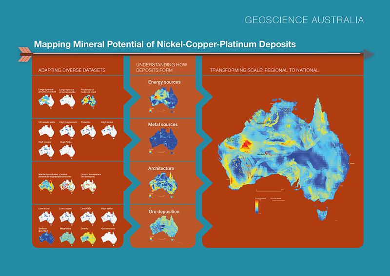
- Adapting diverse datasets: The value of fundamental and extensive geoscientific databases at Geoscience Australia has been unlocked through innovative 'data mining' across multiple geoscientific databases and diverse datasets, yielding new insights on the nation's mineral potential. Many of the datasets have not been used previously in such studies, and required innovative adaptation to be useful in mapping prospectivity.
- Understanding how deposits form: The decision support system integrates the datasets within a robust knowledge framework, based on a geological understanding of how nickel, copper and the PGEs are concentrated into ore deposits, within what is known as a mineral system.
- Transforming scale: regional to national: The project is the first of its type in Australia to be conducted at the continental scale. It shows the way forward for mapping of the nation's mineral potential, not only for nickel-copper-PGEs but also in the future for other metals such as gold, zinc, lead, uranium, rare-earth elements, and other types of copper deposits. This continental study builds upon, and scales-up, a number of earlier regional-scale studies by Geoscience Australia and others.
- New computer programming of the geographic information system (GIS) processing improved the efficiency of the work flow and allowed testing of multiple scenarios.
Impacts and importance of the results
(see Stage 3, Impacts, in figure 1)
The final product of the Mineral Potential Mapper is a new map of Australia highlighting thirteen regions modelled with high potential for Ni-Cu-PGE deposits. The modelling successfully predicts the locations of the regions containing the few known deposits of this type (shown in final result map: Nebo-Babel; Nova; Mount Sholl; Radio Hill; Copernicus; Savannah), even though the deposits were not included as an input dataset. Importantly, the results also predict high potential in several 'greenfields' areas where no deposits are known to exist.
Innovations and Workflow
Unlocking the data
Through the integration of some key national datasets, previously unseen patterns have emerged in the geology and structure of the continent which are of direct relevance to the identification of prospective areas for nickel-copper-PGE deposits. Such large-scale patterns are difficult or impossible to recognise in datasets covering small areas, for example at the scale of individual exploration licences.
Driving exploration investment
The results provide the mineral exploration industry with target regions within which more detailed follow-up and exploration data acquisition will be required to discover new mineral deposits. It is the 'greenfields' areas that will be very attractive for 'first mover' investment, and which hold the lure of discovery of an entire new mineral province.
Shaping Exploring for the Future and industry perspectives
Geoscience Australia's continental-scale approach to the mapping of mineral potential is being utilised in Geoscience Australia's Exploring for the Future program (2016–2024).
Geoscience Australia's Mineral Potential Mapper project shows the way forward by identifying previously unrecognised regions with Ni-Cu-PGE potential. Similar projects in the future will map the potential for other mineral commodities, ultimately creating a National Prospectus of the continent's mineral resources and potential.
The methodology developed for the Mineral Potential Mapper also has the capacity to change the perspectives of much exploration targeting in Australia towards a broader view in which continental-scale datasets are better utilised.
Ingredients for innovation
The innovations in the project emerged out of the necessity for improved understanding Australia's mineral potential, which underpins the nation's resource wealth. The Mineral Potential Mapper was developed by a small team of geoscientists with deep understanding of the geological processes involved in ore formation, as well as possessing strong multidisciplinary and technical skills. This work built upon decades of geological and geophysical mapping of the continent by federal and state/territory geoscience agencies, and relied upon the availability of well-structured and comprehensive geoscientific databases. It was the fusion of the legacy datasets, together with newly created maps, that has enabled fresh insights on Australia's potential for undiscovered mineral resources.
Products of the project on Australia's Ni-Cu-PGE potential
Several technical products of Geoscience Australia's study of the nation's potential for intrusion-hosted Ni-Cu-PGE deposits are available for free download. These include a report, a series of maps images of the input datasets, selected maps from the intermediate stages of processing, and the final map of mineral potential; and computer programming scripts (in Python) for the Arc GIS semi-automated processing of the spatial data.
Endorsements
Feedback on the Mineral Potential Mapper from a workshop for industry on Australia's Ni-Cu-PGE potential, held in Perth on 10 June 2016:
"Geoscience Australia's recent continental-scale mineral system synthesis for mafic-intrusion hosted nickel sulfide systems represents a milestone in the development of the mineral systems approach to exploration targeting". "This is a courageous step that the Geoscience Australia team has taken - they have translated the key elements of this nickel sulfide mineral system into a continental map of prospectivity through a series of transparent steps. To my knowledge, this is the first time in the world that this has ever been attempted".
Award
Geoscience Australia's Mineral Potential Mapper project was awarded as the winner of one of four categories ('Engaging with the Edge') in the Public Sector Innovation Awards, announced on 27 July 2016. This event was organised by the Institute of Public Administration Australia ACT Division.
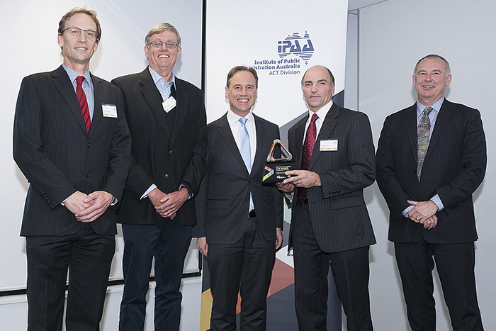
(L-R): Dr Richard Blewett, Geoscience Australia; Dr David Champion (Geoscience Australia); the Hon Greg Hunt MP, Minister for Industry, Innovation and Science; Dr Roger Skirrow, Geoscience Australia; and Dr Gordon de Brouwer PSM, Secretary of the Department of the Environment and Energy and President of IPAA ACT