Stavely Project
Page last updated:23 September 2025
Overview
The Stavely Project was a collaborative project undertaken by Geoscience Australia and the Geological Survey of Victoria from 2013 to 2017. The Project was a contribution to the national UNCOVER Initiative and the Council of Australian Government (COAG) National Mineral Exploration Strategy, which aim to address the challenge of exploring through cover and attracting greenfield mineral exploration through the provision of pre-competitive fundamental geoscience data and concepts.
In partnership with the Deep Exploration Technologies Cooperative Research Centre (DET CRC) fourteen drill holes were completed for 2708.5 metres to test regional geological interpretations, determine the depth and nature of cover and to recover material for subsequent detailed analysis. A combination of sonic drilling to penetrate unconsolidated cover and diamond drilling in more competent rock was undertaken. DET-CRC Lab-at-Rig technology was deployed during drilling. The results of the stratigraphic drilling program, in conjunction with other investigations, have advanced our understanding of buried portions of the Stavely Arc, including its geodynamic setting and evolution, and the mineral potential of this region. Key findings of the Stavely Project are summarised below. More detailed results and interpretations are provided in a report detailing the geology and mineral systems potential of the Stavely Arc.
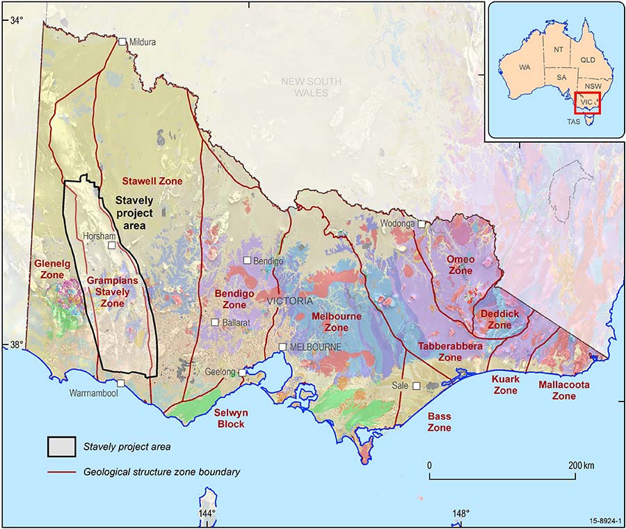
Geological map of Victoria showing the structural geological zones of Victoria, highlighting the Stavely project area. Adapted from Geological Survey of Victoria
Key findings
- The Stavely Arc developed during west-directed subduction along the eastern margin of Gondwana in the Cambrian. Such a setting is favourable for a range of arc-related mineral systems (e.g. porphyry, epithermal and volcanic-hosted massive sulphide systems)
- The Stavely Arc is now preserved as 18 structurally-dismembered, narrow, fault-bound, poorly exposed volcanic belt segments that contain features characteristic of metallogenically well-endowed volcanic arc terranes worldwide. These belt segments are easily identifiable in regional geophysical datasets and have been interpreted to persist under cover
- Removal of the effects of Silurian to Devonian deformation events from the volcanic belt segments restores them to four strike-persistent, sub-parallel volcanic belts that extended, in the Cambrian, for a collective strike length of ~1,160 kilometres
- Recognition of the original along-strike volcanic belt continuity, along with geochemical data (largely derived from material collected during stratigraphic drilling) support the correlation of the volcanic belts under cover. Previously there was confusion about these relationships
- Geochronological data and geological evidence suggests that the volcanic arc was active between at least 511 Ma to 500 Ma, and likely initiated as early as 525 Ma. It appears that porphyry intrusions and associated mineralisation occurred relatively late during arc development, between ~506 and 500 Ma. This timing post-dates the main phase of the Delamerian Orogeny which tilted and faulted the volcanic belts. Any mineral systems associated with late orogenic intrusions would, therefore, likely be preserved upright and may also occur outside of the volcanic belts themselves in the intervening panels of Cambrian sedimentary rock. This greatly expands the mineral exploration search space in the Stavely Arc beyond the volcanic belts themselves
- Geochemical data for volcanic and intrusive igneous rocks of the Stavely Arc demonstrate close affinities to present-day continent-fringing island arcs with a core of thinned continental crust. The new geodynamic model proposed for the Stavely Arc involves evolution from a Neoproterozoic passive margin through to an extension-dominated Japan-style arc and evolving to a more Andean-style system during the late stages of the Delamerian Orogeny
- Re-examination of the geological significance of mineral occurrences located in the small areas of exposure in the Stavely Arc (e.g. Stavely and Black Range belt segments, and in adjacent Cambrian sedimentary rocks), together with new sulphur isotope data, show features consistent with porphyry, epithermal, and volcanic-hosted massive sulphide styles of mineralisation. Given that host volcanic belts have been shown to continue under cover, it is also predicted that additional mineral occurrences may occur under cover
- Lead isotope data derived from mineral occurrences in the Stavely Arc are dominated by a crustal source. A comparison with lead isotope data derived from mineral deposits to the east of the Stavely Arc indicate that the boundary between the Stavely Arc and the Stawell Zone (the Moyston Fault) is a major terrane boundary structure
- The lead isotope data for the Stavely Arc mineral occurrences also differ from those derived from the Mount Read Volcanics o western Tasmania, suggesting that the Stavely Arc does not represent the northern extension of the Mount Read Volcanics, but is rather a separate metallogenic province. Relative to the Mount Read Volcanics, the Stavely Arc is considered to have greater potential for porphyry and epithermal mineral systems
- Since the Devonian, the Stavely Arc has undergone relatively little uplift, which means that potential arc-related mineral systems are likely to have a high preservation potential. Some of the mineral occurrences show evidence for near-surface supergene copper enrichment.
Regional Geology of the Stavely Project
The Stavely Project area of investigation is located within the known southern extent of the Stavely Arc, which is now preserved as 18 structurally-dismembered, fault-bound belts of Cambrian volcanic rocks and related intrusive rocks that contain features characteristic of mineralised volcanic arc terranes worldwide. Structural restoration of the Stavely Arc shows that it initially was comprised of four strike-persistent, sub-parallel volcanic belts that extended for a collective strike length of approximately 1,160 km in the Cambrian. Rocks of the Stavely Arc are exposed at the surface in several locations in the southeast of the project area. However, the majority of the arc is concealed by a veneer of younger sedimentary and volcanic rocks.
A number of known historical mineral occurrences are associated with exposed portions of the volcanic belts and several of these prospects are being actively explored for base and precious metals. The Stavely Project has mapped out where these prospective volcanic belts continue under cover and, in doing so, has identified a new exploration search space with untested potential and opportunities for the discovery of economic mineralisation.
New geoscience information
- Regional geology and mineral systems of the Stavely Arc, western Victoria. Report outlining the key findings of the Stavely Project. The report details the new stratigraphic, geochronological, structural, geochemical, and mineral systems understanding of the Stavely Arc, and draws together these lines of evidence to present new concepts for the regional geological framework and geodynamic setting of the Stavely Arc, and its mineral systems potential
- Ground Gravity Traverses 2016 (Geological Survey of Victoria report). This report details a survey that collected ground gravity data from ~3,500 stations at 200 metre spacing acquired along 724 kilometres of roads across the Stavely Arc
Previous Stavely Project releases
- Regional geology and mineral systems of the Stavely region, western Victoria - stratigraphic drilling field data report and drilling field data
- Anomalous Gold and Base Metal Mineralisation in Regional Pre-competitive Drilling as Part of the Geological Survey of Victoria-Geoscience Australia Stavely Project
- Regional geology and mineral systems of the Stavely region, western Victoria - HyLogger data and catalogue
- New SHRIMP U-Pb zircon ages from the Stavely region, western Victoria - July 2013-June 2014
- New SHRIMP U-Pb zircon ages from the Stavely region, western Victoria: July 2014-June 2016
- Regional geology and mineral systems of the Stavely region, western Victoria - Stratigraphic drilling lithology logs
- Regional geology and mineral systems of the Stavely region, western Victoria - drill core rock property measurements
- Regional geology and mineral systems of the Stavely region, western Victoria - geochemistry data
- Regional geology and mineral systems of the Stavely region, western Victoria - pre-drilling geophysics report and data
Download image of preferred geodynamic model for the evolution of the Stavely Arc [JPG 5.2 MB] showing the likely timing and relative location of mineral systems (both demonstrated and conceptual in nature)
![preferred geodynamic model for the evolution of the Stavely Arc [JPG 5.2 MB]](https://www.ga.gov.au/scientific-topics/minerals/unlocking-resource-potential/stavely-project/Fig_4.14_min-syst-interp-on-geodyn-cartoons.jpg)