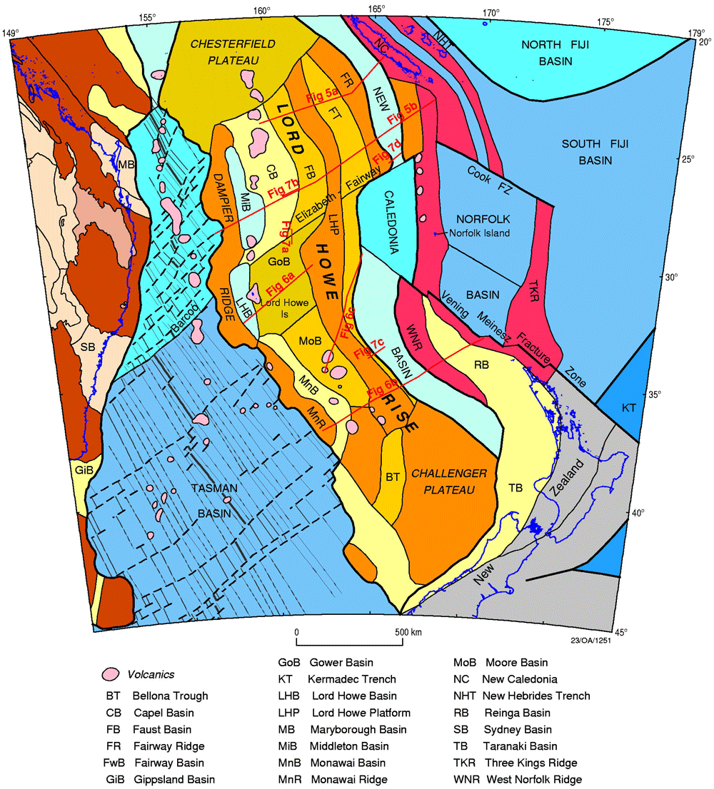
Lord Howe Rise
Page last updated:27 June 2014
Basin Details and Geological Overview
The Lord Howe Rise (LHR) is a major submerged plateau that extends almost 2000km from southwest of New Caledonia to the Challenger Plateau, west of New Zealand (Location Map). Much of the LHR lies within the Australian marine jurisdiction, at water depths of 1000–3000m. It is a vast frontier region of about 1 500 000km2 with little previous scientific or resource exploration. The sparse data coverage consists of regional 2D seismic, gravity, magnetic and bathymetry data. DSDP drill holes (e.g. DSDP 207 and 208) provide the only existing well data for the uppermost part of the sedimentary succession. No petroleum exploration wells have yet been drilled. A few dredge samples provide information on the nature and age of basement and magmatism in the LHR, the Dampier Ridge and the Challenger Plateau. Recent work by Geoscience Australia in the Capel and Faust basins has significantly improved the data coverage and geological knowledge over the northern LHR. This study has also confirmed that the LHR contains sedimentary basins that are potentially capable of generating and accumulating petroleum.
The LHR is interpreted to be a continental fragment that rifted from eastern Australia during the Cretaceous break-up of Eastern Gondwana margin and the Tasman Sea opening (85–52 Ma). Refraction seismic, gravity and magnetic data suggest that rifting extended the continental crust beneath the LHR to varying degrees. The crustal thickness generally decreases westward, indicating an increase in crustal stretching toward the Tasman Sea. Rock samples and tectonic reconstructions suggest that the LHR is underlain by offshore continuations of the Paleozoic to Mesozoic orogens and basins of eastern Australia, New Zealand and New Caledonia.
ProvExplorer
- Capel Basin Details and Geological Overview
- Faust Basin Details and Geological Overview
- Gower Basin Details and Geological Overview
- Kenn Plateau Details and Geological Overview
- Mellish Rise Details and Geological Overview
Structural Elements
The LHR comprises four sub-parallel geological provinces that extend along its length: the Lord Howe Platform, the Central Rift Province, the Western Rift Province, and the Dampier and Monowai ridges.
The Lord Howe Platform is a shallow, planated ridge forming the eastern flank of the LHR. It is composed of pre-rift basement rocks that underwent little stretching during Cretaceous rifting. It is thinly mantled by a few hundred metres of mainly Cenozoic siliceous and carbonate oozes and Cretaceous–Cenozoic volcanic rocks. Its boundary with the Fairway, New Caledonia and Aotea basins to the east is marked by a scarp and an abrupt deepening of the basement surface.
The Central Rift Province, west of the Lord Howe Platform, consists of basement blocks and normally faulted basin depocentres with up to 4km of Cretaceous to Cenozoic syn- and post-rift sediments. The underlying continental crust is moderately extended (about 20km thickness). This province includes the Faust Basin in the north and the Moore Basin in the south.
The Western Rift Province to the west of the Central Rift Province contains large normally faulted depocentres with up to 6km of Cretaceous to Cenozoic syn- and post-rift sediments. Sediment thickness and water depths generally increase westward across the Central and Western Rift provinces. The Western Rift Province includes the Capel Basin in the north and the Monowai Basin in the south. In the central LHR, the Central and Western Rift provinces cannot be separated and the combined province has been named the Gower Basin.
The Dampier Ridge in the north and the Monowai Ridge in the south form the boundary between the LHR and the oceanic crust of the Tasman Sea Basin to its west. The ridges are composed of continental crust; the Dampier Ridge is partly composed of Permian granite. The Dampier Ridge is separated from the Western Rift Province by the Lord Howe and Middleton basins, These basins are underlain by highly extended continental or transitional crust.
A series of SW–NE fracture zones extending from the oceanic crust of the Tasman Sea fragment the Lord Howe Rise into discrete microcontinents. These include the Barcoo–Elizabeth–Fairway Lineament separating the Capel and Faust basins from the Gower Basin. In addition, an extension of the Vening–Meinesz Fracture Zone appears to extend into the eastern flanks of the Lord Howe Rise from the southeast.
Lord Howe Rise Structural Aspects
Stratigraphy
One pre-rift, two syn-rift and one post-rift seismic megasequences have been identified in the Capel and Faust basins of the northern LHR. Further south in the Gower Basin, these megasequences have been subdivided into 11 seismic sequences. The top of the (mega-) sequences are bounded by unconformities and their correlative conformities. Regional correlations indicate that the stratigraphy is broadly similar over most of the LHR. Many of the unconformities correspond to regional unconformities that may be related to major plate tectonic or oceanographic events. The age, composition and depositional environment of the (mega-) sequences have been inferred from regional tectonic reconstructions, DSDP well ties, and correlations with analogue basins in eastern and southern Australia, New Zealand and New Caledonia.
The pre-rift succession (Pre-rift in the Capel-Faust basins, GB11 and GB10 in the Gower Basin) is likely to comprise Paleozoic and Mesozoic rocks that correlate with the Tasman Orogen of eastern Australia and the accretionary terranes of New Zealand and New Caledonia. The Paleozoic rocks may include the equivalents of the New England Orogen in the northern LHR and the Lachlan Orogen in the southern LHR. Mesozoic sedimentary rocks that are probably equivalent to the Maryborough, Clarence-Moreton and Sydney basin successions are also present. Volcanic, intrusive and volcaniclastic rocks, either of pre-rift or earliest syn-rift age, are widespread in some parts of the LHR. These rocks may correlate with the earliest phases of the latest Jurassic to Early Cretaceous regional magmatism along the former eastern Gondwana margin, e.g. the lower Grahams Creek Formation in the Maryborough Basin and the Casterton Formation of the Crayfish Supersequence in the Otway Basin. Continued development of the eastern Gondwanan magmatic rift led to syn-rift deposition across the LHR region during the Early Cretaceous.
The Early Cretaceous rifting event in the LHR region (Syn-rift 1 in the Capel-Faust basins, GB9 and 8 in the Gower Basin) is inferred to have taken place during the Early Cretaceous. In the northern LHR, a pre-existing NW–SE basement structural trend appears to have interacted with an oblique extensional vector to form NNE–SSW trending depocentres. Seismic character and analogue basin studies suggest that Early Cretaceous syn-rift deposition was dominated by volcaniclastic, fluvial and fan sediments, volcanics and intrusives, and localised coal and lacustrine sediments. The succession probably correlates with the upper Grahams Creek Formation in the Maryborough Basin, Strzelecki Group in the Gippsland Basin and the Eumeralla Supersequence in the Otway Basin. Deposition ended with the Cenomanian uplift, erosion and basin inversion that is widely documented from eastern and southern Australia, New Zealand and New Caledonia. Previous work attributes the tectonic event to a major reorganisation of the relative motions between Australian, Pacific and Antarctic plates.
A second rifting event (Syn-rift 2 in the Capel-Faust basins, GB7 in the Gower Basin) affected the LHR during the Late Cretaceous. Rifting was focused in the Western Rift Province and appears to be related to the opening of the Tasman Sea to the west of the LHR. In the Capel and Faust basins, the earlier formed NNE–SSW trending depocentres were overprinted by NW–SE trending structures. Sediments deposited during this phase are likely to be predominantly fluvial. As the Tasman Sea Basin opened, marine conditions spread northwards along the LHR resulting in marginal and shallow marine deposition by the Campanian. The succession is likely to correlate with the Emperor and Golden Beach subgroups of the Gippsland Basin and the Taniwha and Rakopi formations of the Taranaki Basin. Volcanism appears to have been common over the LHR during the Late Cretaceous. Trachyte and latite samples recovered during the AUSFAIR survey to the southeast of the Faust Basin have been U-Pb dated by ion microprobe (SHRIMP) at 97 and 74 Ma, while rhyolite from the DSDP 207 drilling site on the southern Lord Howe Rise was previously dated at c. 94 Ma.
Thermal subsidence of the region from the Late Cretaceous to the present has resulted in marine deposition under progressively deepwater conditions. In the earlier part of this post-rift phase, marginal marine to mid-bathyal clastic sediments were deposited. Seismic data have revealed features that may be deltaic, shoreline and turbidite sand bodies. Since the Late Maastrichtian, bathyal conditions have dominated, resulting in the deposition of chalk, marl and calcareous ooze as seen at DSDP 207 and 208 drill holes. The lateral continuity and thickness make these fine-grained sediments a potential regional seal for petroleum traps. Pulses of igneous and tectonic activity are recorded during the Maastrichtian–Paleocene/Eocene, the Late Oligocene–Miocene and the Pliocene. Magmatism associated with these events has produced widespread small volcanic cones, flows and sills. The northwestern part of the LHR is also traversed by the Lord Howe seamount chain. Post-rift magmatism in the LHR region appears to have triggered fluid migration, which has extensively affected the post-rift sediments and continues to shape features on the seafloor today. Major regional unconformities also occur during the Paleocene–Eocene and Eocene–Oligocene, which may be related to a reorganisation of plate tectonic motion (e.g. the Hawaiian–Emperor bend) and/or regional oceanic circulation.
| Age | Event | Depositional facies | Regional correlation | Capel-Faust megasequence | Gower mega sequence |
|---|---|---|---|---|---|
| Maastrichtian-Recent | Post-rift thermal subsidence; intra-plate magmatism, uplift, erosion, fault reactivation and structuring at Paleocene-Eocene, Eocene-Oligocene, Miocene and Pliocene | Mainly bathyal foraminiferal-nannofossil ooze; general upward deepening and increase in calcareous component; some shallow marine about structural highs during uplift events | Units 2 and 1 at DSDP208 on northern LHR, Units 2 and 1 at DSDP 207 on southern LHR | Post-rift (Upper Sag) | GB5 to GB1 |
| ?Campanian- Maastrichtian | Post-rift thermal subsidence and clastic deposition; some fault reactivation | Deltaic, coastal plain and shallow marine; some fluvial and lacustrine; deepening over time to bathyal | Bottom Unit 2 at DSDP 208 on northern LHR, Unit 3 at DSDP 207 on southern LHR, Latrobe Group of Gippsland Basin | Post-rift (Lower Sag) | GB6 |
| ?Cenomanian-Campanian | Renewed rifting and clastic-dominated deposition leading up to Tasman Sea opening to the west; terminated by regional uplift, erosion and structuring (break-up unconformity) | Fluvial-dominated, giving way to deltaic, coastal plain and shallow marine; some volcanic, intrusive and lacustrine | Emperor and Golden Beach subgroups of the Gippsland Basin, Taniwha and Rakopi formations of the Taranaki Basin | Syn-rift 2 | GB7 |
| ?Early Cretaceous | Major rifting, deposition and magmatism associated with volcanic rift development along the eastern Gondwana margin; terminated by Cenomanian uplift, erosion and structuring | Volcanic, intrusive, volcaniclastic, fluvial and fan; some coal and possible lacustrine | Upper Grahams Creek Formation of the Maryborough Basin, Strzelecki Group of the Gippsland Basin, Eumeralla Supersequence of the Otway Basin | Syn-rift 1 | GB9, GB8 |
| Palaeozoic and Mesozoic | Pre-rift to initial extension | Sedimentary, igneous and metamorphic basement, folded and faulted to varying degrees; may include initial stages of rifting and associated igneous rocks | New England Orogen, Maryborough Basin and Clarence-Moreton Basin, in the north; Lachlan Orogen, Sydney Basin and Gippsland Basin in the south | Pre-rift | GB11, GB10 |
Petroleum Systems and Hydrocarbon Potential
In terms of conventional hydrocarbons, the deeper sedimentary depocentres of the Central and Western Rift provinces have sufficient sediment thickness for the potential generation and expulsion of hydrocarbons.
Coaly potential petroleum source rocks may be present in the pre-rift sedimentary rocks, if the succession is a correlative of the Maryborough, Clarence-Moreton and Sydney basins. Coaly and lacustrine potential source rocks may also occur in the Cretaceous syn-rift megasequences, by analogy with the eastern Australian and New Zealand basins. 1D basin modelling has indicated that potential source rocks within the pre-rift and lower syn-rift sections would be capable of generating and expelling oil and gas. Potential reservoir rocks may be found in fluvial sandstones within the syn-rift succession and the deltaic, shoreline and shallow marine sandstones in the upper syn-rift and lower post-rift successions. The upper post-rift deep marine sediments may act as a regional seal.
Expected major trapping styles include fault-related plays, stratigraphic pinch-outs, unconformity plays, and drape and anticlinal structures. 3D geological modelling indicates the existence of several large potential anticlinal structures with likely four-way closure.
Majority of the petroleum generation and migration is expected to have occurred before most trapping structures and the potential regional seal were in place by the Oligocene. However, a significant amount of generation is also likely after this time. Cenozoic igneous activity may have enhanced late-stage petroleum generation. On the other hand, the widespread fluid migration triggered by the Cenozoic magmatism is a major risk for seal integrity of the upper post-rift sediments.
Much of the previous petroleum exploration interest in the LHR region related to the possibility of vast gas hydrate occurrences within the post-rift sediments. This interpretation was based on the widely distributed bottom simulating reflectors (BSRs) seen on regional seismic data. However, an appraisal of recently acquired high-resolution seismic data and shallow sediment cores collected during the AUSFAIR MD-153 survey has indicated that the BSRs are most likely to be an Opal-A/Opal-CT diagenetic boundary.
Key References
| Author(s) | Year | Title |
|---|---|---|
| Andrews, J.E. | 1973 | Correlation of seismic reflectors. In: Burns, R.E. and Andrews, J.E., (Eds), Initial Reports of the Deep Sea Drilling Project, 21, 459–479. |
| Bernardel, G., Lafoy, Y., van de Beuque, S., Missegue, F. and Nercessian, A. | 1999 | Preliminary results from AGSO Law of the Sea Cruise 206: an Australian/French collaborative deepseismic marine survey in the Lord Howe Rise/New Caledonia region Australian Geological Survey Organisation Record 1999/14. |
| Blevin, J.E. | 2001 | Hydrocarbon prospectivity of Australia's remote frontier areas in offshore east and southeast Australia: examples from the basins of Lord Howe rise. In: Hill, K.C. and Bernecker, T., (Eds), Eastern Australasian Basins Symposium: a refocussed energy perspective for the future. Petroleum Exploration Society of Australia Special Publication, 25–35. |
| Burns, R.E., Watters, W.A., Webb, P.N. and the Shipboard Party | 1973 | Site 207. In: Burns, R.E. and Andrews, J.E., (Eds), Initial Reports of the Deep Sea Drilling Project, 21, 197–269. |
| Burns, R.E., Webb, P.N. and the Shipboard Party | 1973 | Site 208. In: Burns, R.E. and Andrews, J.E., (Eds), Initial Reports of the Deep Sea Drilling Project, 21, 271–331. |
| Collot, J., Géli, L., Lafoy, Y., Vially, R., Cluzel, D., Klingelhoefer, F. and Nouzé, H. | 2008 | Tectonic history of northern New Caledonia Basin from deep offshore seismic reflection: relation to late Eocene obduction in New Caledonia, southwest Pacific. Tectonics, 27, TC6006. |
| Colwell, J.B., Hashimoto, T., Rollet, N., Higgins, K., Bernardel, G. and McGiveron, S. | 2010 | Interpretation of Seismic Data, Capel and Faust Basins, Australia's Remote Offshore Eastern Frontier. Geoscience Australia Record, 2010/06. |
| Exon, N.F., Dickens, G.R., Auzende, J-M., Lafoy, Y., Symonds, P.A. and van de Beuque, S. | 1998 | Gas hydrates and free gas on the Lord Howe Rise. Petroleum Exploration Society of Australia Journal, 26, 148–58. |
| Exon, N.F., Quilty, P.G., Lafoy, Y., Crawford, A.J., Auzende, J-M. | 2004 | Miocene volcanic seamounts on northern Lord Howe Rise: lithology, age and origin. Australian Journal of Earth Sciences, 51, 291–300. |
| Gaina, C., Müller, D.R., Royer, J-Y., Stock, J., Hardebeck, J. and Symonds, P. | 1998 | The tectonic history of the Tasman Sea: a puzzle with 13 pieces. Journal of Geophysical Research, 103(B6), 12413–12433. |
| Hackney, R., Petkovic, P., Hashimoto, T., Higgins, K., Logan, G., Bernardel, G., Colwell, J., Rollet, N. and Morse, M. | 2009 | Geophysical studies of Australia's remote eastern deep-water frontier: results from the Capel and Faust Basins. 20th International Geophysical Conference and Exhibition, Australian Society of Exploration Geophysicists Extended Abstracts 2009(1) |
| Hashimoto, T., Higgins, K., Hackney, R., Stagpoole, V., Uruski, C., Rollet, N., Bernardel, G., Logan, G. and Sutherland, R. | 2009 | Capel and Faust basins: integrated geoscientific assessment of Australia's remote offshore eastern frontier. The Australian Petroleum Production and Exploration Association Conference 2009. The APPEA Journal, 49, extended abstracts. |
| Hashimoto, T., Rollet, N., Earl, K. and Bernardel, G. | 2008 | Capel and Faust basins—new information from the offshore frontier between Australia, New Zealand and New Caledonia. 2008 New Zealand Petroleum Conference Proceedings, Crown Minerals, Ministry of Economic Development. |
| Hashimoto, T., Rollet, N., Higgins, K., Bernardel, G. and Hackney, R. | 2008 | Capel and Faust basins: Preliminary assessment of an offshore deepwater frontier region. In: Blevin, J.E., Bradshaw, B.E. and Uruski, C. (Eds), Eastern Australasian Basins Symposium III: Energy security for the 21st century, Petroleum Exploration Society of Australia Special Publication, 311–316. |
| Heap, A., Hashimoto, R. and Rollet, N. | 2008 | Survey of remote eastern frontier basins completed: New survey delivers high-quality prospectivity and environment data. AusGeo News, 89, 1–5. |
| Heap, A.D., Hughes, M., Anderson, T., Nichol, S., Hashimoto, T., Daniell, J., Przeslawski, R., Payne, D., Radke, L. and Shipboard Party | 2009 | Seabed environments of the Capel and Faust basins and Gifford Guyot, eastern Australia, TAN0713 post-survey report. Geoscience Australia Record, 2009/22. |
| Klingelhoefer, F., Lafoy, Y., Collot, J., Cosquer, E., Géli, L., Nouzé, H. and Vially, R. | 2007 | Crustal structure of the basin and ridge system west of New Caledonia (southwest Pacific) from wide-angle and reflection seismic data, Journal of Geophysical Research, 112, B11102 |
| Kroh, F. | 2007 | Promising results from Capel and Faust Basins seismic survey. AusGeo News 86, 6. |
| Kroh, F., Morse, M.P. and Hashimoto, T. | 2007 | New data on the Capel and Faust basins. Preview, 130, 22–24. |
| McDougall, I., Maboko, M.A.H., Symonds, P.A., McCulloch, M.T., Williams, I.S. and Kudrass, H.R. | 1994 | Dampier Ridge, Tasman Sea, as a stranded continental fragment. Australian Journal of Earth Sciences, 41(5), 395–406. |
| Mortimer, N., Hauff, F. and Calvert, T. | 2008 | Continuation of the New England Orogen, Australia, beneath the Queensland Plateau and Lord Howe Rise. Australian Journal of Earth Sciences, 55, 195–209. |
| Norvick, M.S., Smith, M.A. and Power, M.R. | 2001 | The plate tectonic evolution of eastern Australasia guided by the stratigraphy of the Gippsland Basin. In: Hill, K.C., and Bernecker, T., (Eds), Eastern Australasian Basins Symposium: a refocussed energy perspective for the future. Petroleum Exploration Society of Australia Special Publication, 15–24. |
| Norvick, M.S., Langford, R.P., Rollet, N., Hashimoto, T., Higgins, K.L. and Morse, M.P. | 2008 | New insights into the evolution of the Lord Howe Rise (Capel and Faust basins), offshore eastern Australia, from terrane and geophysical data analysis. In: Blevin, J.E., Bradshaw, B.E. and Uruski, C. (Eds), Eastern Australasian Basins Symposium III: Energy security for the 21st century, Petroleum Exploration Society of Australia Special Publication, 291–310. |
| Nouzé, H., Cosquer, E., Collot, J., Foucher, J-P., Klingelhoefer, F., Lafoy, Y. and Géli, L. | 2009 | Geophysical characterisation of bottom simulating reflectors in the Fairway Basin (off New Caledonia, Southwest Pacific), based on high resolution seismic profiles and heat flow data. Marine Geology, 266, 80–90. |
| Petkovic, P. | 2007 | Preliminary results from marine seismic survey GA302 over Capel and Faust Basins. 19th International Geophysical Conference and Exhibition, Australian Society of Exploration Geophysicists Extended Abstracts 2007(1) |
| Petkovic, P. | 2008 | Preliminary results from marine seismic survey GA302 over Capel and Faust Basins. Preview, 132, 31–34. |
| Petkovic, P. | 2010 | Seismic velocity models of the sediment and upper crust of the Capel and Faust Basins, Lord Howe Rise. Geoscience Australia Record, 2010/03. |
| Shor, G.G., Kirk, H.K. and Menard, H.W. | 1971 | Crustal Structure of the Melanesian Area. Journal of Geophysical Research, 76(11), 2562–2586. |
| Stagg, H.M.J., Alcock, M., Borissova, I. and Moore, A. | 2002 | Geological framework of the southern Lord Howe Rise and adjacent areas. Geoscience Australia Record, 2002/25. |
| Stagg, H.M.J., Borissova, I., Alcock, M. and Moore, A.M.G. | 1999 | Tectonic provinces of the Lord Howe Rise: Law of the Sea study has implications for frontier hydrocarbons. AGSO Research Newsletter, 31, 31–32. |
| Sutherland, R., Collot, J., Lafoy, Y., Logan, G.A., Hackney, R., Stagpoole, V., Uruski, C., Hashimoto, T., Higgins, K., Herzer, R., Wood, R., Mortimer, N. and Rollet, N. | 2010 | Lithosphere delamination with foundering of lower crust and mantle caused permanent subsidence of New Caledonia Trough and transient uplift of Lord Howe Rise during Eocene and Oligocene initiation of Tonga–Kermadec subduction, western Pacific. Tectonics, 29, TC2004 |
| Symonds, P.A. and Willcox, J.B. | 1989 | Australia's petroleum potential beyond an Exclusive Economic Zone. BMR Journal of Australian Geology and Geophysics, 11, 11–36. |
| Van de Beuque, S., Stagg, H.M.J., Sayers, J., Willcox, J.B. and Symonds, P.A. | 2003 | Geological framework of the northern Lord Howe Rise and adjacent areas. Geoscience Australia Record, 2003/01. |
| Van der Lingen, G.J. | 1973 | The Lord Howe Rise rhyolites. In: Burns, R.E. and Andrews, J.E., (Eds), Initial Reports of the Deep Sea Drilling Project, 21, 523–539. |
| Willcox, J.B. and Sayers, J. | 2001 | Gower Basin, Lord Howe Rise. In: Hill, K.C. and Bernecker, T. (Eds), Eastern Australasian Basin Symposium 2001: a refocussed energy perspective for the future, Petroleum Exploration Society of Australia Special Publication, 189–200. |
| Willcox, J.B., Sayers, J., Stagg, H.M.J. and van de Beuque, S. | 2001 | Geological framework of the Lord Howe Rise and adjacent ocean basins. In: Hill, K.C. and Bernecker, T. (Eds), Eastern Australasian Basin Symposium 2001: a refocussed energy perspective for the future, Petroleum Exploration Society of Australia Special Publication, 211–225. |
| Willcox, J.B. and Sayers, J. | 2002 | Geological framework of the central Lord Howe Rise (Gower Basin) region. Geoscience Australia Record, 2002/11. |