Clarence-Moreton Basin
Page last updated:27 June 2014
Basin Details and Geological Overview
The Late Triassic to Late Jurassic Clarence-Moreton Basin is situated in southeast Queensland and northeast New South Wales and covers about 26 000km2 onshore and at least 1 000km2 offshore in water depths up to 90 metres. The basin and its precursors, the Esk Trough, Nymboida Basin and Ipswich Basin developed on a basement cut by major long-lived, dextral strike-slip faults (West Ipswich, Coraki and Coast Range Faults). Movement along these produced crustal transtension which was followed in the latest Triassic to Late Jurassic by a period of thermal relaxation and subsidence which formed the Basin.
The Basin is subdivided into three main depocentres, the Logan, Laidley and Cecil Plains Sub-basins, with the much smaller Yamba Trough extending offshore from the eastern margin of the Logan Sub-basin. The Logan Sub-basin contains the greatest thickness of sediments with up to 3 000 metres of fluvial and lacustrine siliciclastics and coal with minor basaltic volcanics.
The Basin is poorly explored with sparse seismic coverage. Only about 30 wells have been drilled, two of which (Clifden-2 and Hogarth-2 in the Logan Sub-basin), flowed subeconomic gas. The basin has abundant oil-prone organic matter in the Walloon Coal measures and the subjacent Koukandowie Formation. These units grade from immature in the northwest to overmature in the southeast of the basin and petroleum generation probably commenced during the mid Cretaceous. This was at about the same time as a compressional tectonic episode led to erosion of up to 3 000 metres of Jurassic sediments from the Logan Sub-basin and the creation of the proven structural traps.
Proven reservoirs lie within the Woogaroo and Marburg Subgroups and potential plays in the basin are related to pinchouts and drapes over pre-basin topography, hangingwall anticlines on minor thrusts and stratigraphic traps. Limited seismic data suggest that the offshore extension of the basin may cover a greater area than is currently proven.
Basin Summary Table
| State(s) | New South Wales, Queensland | |
| Area (km2) | Offshore | 1 000 + (offshore extent poorly known) |
| Onshore | 26 000 | |
| Maximum thickness (m) | 3 000+ | |
| Age Range | Late Triassic to Late Jurassic. | |
| Basin | Overlies | Ipswich Basin, New England Fold Belt. |
| Underlies | Cainozoic volcanics; alluvium and coastal facies. | |
| Subdivisions | Cecil Plains, Laidley, Logan Sub-basins. | |
| Other | Yamba Trough (of Logan SB) is mainly offshore. | |
| Indicators | Knowledge | Moderate geophysical and well data onshore; sparse geophysical data only offshore. |
| Basin type | Intracratonic sag following crustal transtension. | |
| System(s) | Murta. | |
| Water Depth (m) | 0 - 90 (mainly 20 - 70). | |
| Exploration | Status | Frontier offshore; Immature onshore. |
| Wells | Over 50 deep exploration, all onshore. | |
| Seismic line-km | > 1 000 2D onshore, one small survey offshore. | |
| Discoveries | Horgarth (uneconomic gas). | |
| Shows | Numerous gas shows, minor oil shows. | |
| HC evidence | Appears to be an operating gas-prone petroleum system; an oil-prone system is also possible. | |
| Geology | Source(s) | Middle Jurassic Walloon Coal Measures has best potential as an oil source; older section is gas prone. |
| Reservoirs | Several sandstone units within the Late Triassic to Early Jurassic Bundamba Group. | |
| Seals | Intraformational flood plain shales in several units. | |
| Trap types | 1) Drape over; or 2) pinchout against sub-Clarence-Moreton topography; 3) hanging wall anticlines on minor thrusts; 4) stratigraphic traps. | |
| Palaeogeographic summary | Mainly fluvial throughout, with coal swamp and lacustrine facies at various times and places. | |
| Timing | Oil generation | Late Cretaceous. |
| Gas generation | Late Cretaceous to Neogene | |
| Trap formation | 1 and 2 - Late Triassic; 3 - Late Triassic to Early Cretaceous; 4 - Late Triassic to Late Jurassic. | |
| Other key times | Early Cretaceous folding; Late Cretaceous to Palaeogene erosion. | |
| Other important information | 1) The Solitary Islands Marine National Park and Reserve are both near a possible offshore extension of the basin. 2) The offshore basin lies under a whale migration path for several months of the year. 3) A detailed Southeast Queensland dataset that includes the onshore basin is available from the Queensland Department of Natural Resources and Mines. | |
| Geoscience Australia products available | 1) Wells and O'Brien, 1994. Bulletin 241. 2) Cadman and others, 1998. APA Report 11. | |
Regional Cross-sections
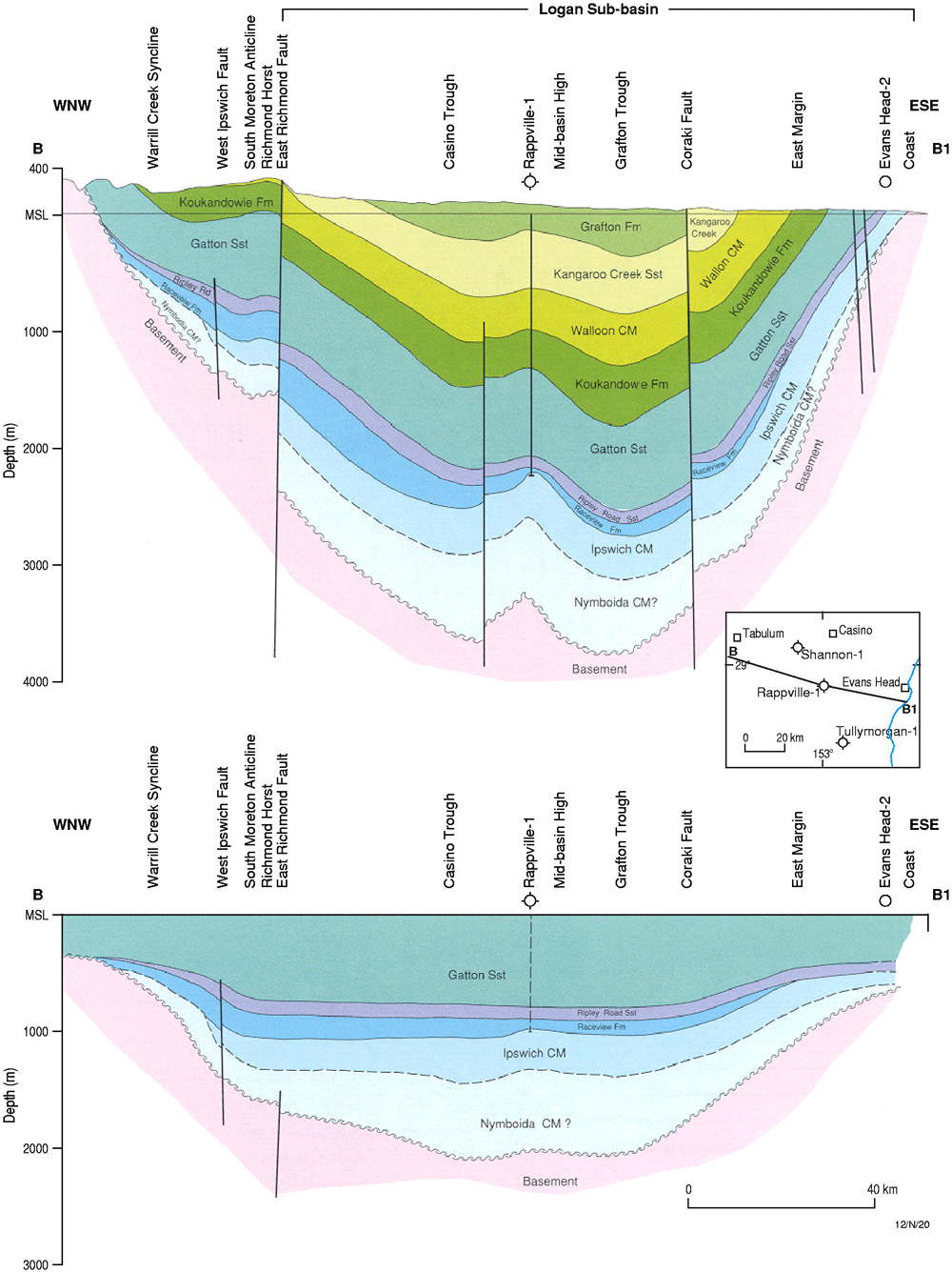
Clarence-Moreton Basin Cross Section
Key References
| Author(s) | Year | Title |
|---|---|---|
| Alder, J.D. | 2001 | Offshore Clarence-Moreton - an overlooked basin with petroleum potential. PESA News, 54 (October-November 2001), 2001 NSW Supplement, 5-7 |
| Benstead, W.L. | 1976 | Clarence-Moreton Basin. Australasian Institute of Mining and Metallurgy, 7, Economic geology of Australia and New Guinea; 3, Petroleum, 454-456 |
| Cadman, S. J., Pain, L. and Vuckovic, V. | 1998 | Bowen and Surat Basins, Clarence Morton Basin, Sydney Basin, Gunnedah Basin and other minor onshore basins, Queensland, NSW and NT. Australian Petroleum Accumulations Report 11, Bureau of Resource Sciences, Canberra |
| Harrington, H.J., & Korsch, R.J. | 1985 | Late Permian to Cainozoic tectonics of the New England Orogen. Australian Journal of Earth Sciences, 32, 181-203 |
| Ingram, F.T. & Robinson, V.A. (R.A. Facer, Editor) | 1996 | Petroleum Prospectivity of the Clarence-Moreton Basin in New South Wales. New South Wales Department of Mineral Resources, Petroleum Bulletin 3, Sydney, 133pp |
| Laing, A.C.M. | 1984 | Regional study of the Triassic and Jurassic of the Moreton Basin with particular reference to the petroleum prospects of ATP282P, Queeensland. Queensland Petroleum Pty Ltd. Unpublished report held by the Queensland Department of Mines as CR 13491 |
| Lockwood, K. | 1978 | A summary of the regional geology, geophysics and petroleum potential of the Clarence-Moreton Basin. Bureau of Mineral Resources Geology and Geophysics, Record 1978/109 |
| Martin, A.R. & Saxby, J.D. | 1982 | Geology, source rocks and hydrocarbon generation in the Clarence-Moreton Basin. The Australian Petroleum Production and Exploration Association (APEA) Journal, 22, part 1, 5-16 |
| McElroy, C.T. | 1969 | The Clarence-Moreton Basin in New South Wales. Journal of the Geological Society of Australia, 16, part 1, 457-479 |
| Nicholson, D.A. (Markham, N.L. & Basden, H., Editors) | 1975 | Clarence-Moreton Basin. The mineral deposits of New South Wales, 539-554 |
| Rane Resources Pty Ltd | 1979 | Moreton Basin. Wilson and CO, Ocean Resources NL. Unpublished report held by the Queensland Department of Mines as CR 8121 |
| Shaw, R.D., Alder, J.D. & Aadil, N. | 2001 | The offshore Clarence-Moreton Basin in New South Wales: A new petroleum play?. Eastern Australasian Basins Symposium 2001. 201-211 |
| Ties, P., Shaw, R.D. & Geary, G.C. | 1985 | The petroleum prospectivity of the Clarence-Moreton Basin in New South Wales. The APEA Journal, 25, part 1, 15-33 |
| Oil and Minerals Quest NL, Mincorp Ltd, Capital Oil Pty Ltd and Pasadena Projects Pty Ltd | Exploration reports, PEL 257, Clarence-Moreton Basin. New South Wales Department of Mineral Resources, Petroleum geology report (Quarterly), June, 1981 | |
| Powell, T.G., O'Brien, P.E. & Wells, A.T. | 1993 | Petroleum prospectivity of the Clarence-Moreton Basin, eastern Australia, a geochemical perspective. Australian Journal of Earth Sciences, 40, part 1, 31-44 |
| Wells, A.T., & O'Brien, P.E. (Editors) | 1994 | Geology and petroleum potential of the Clarence-Moreton Basin, New South Wales and Queensland. Bureau of Mineral Resources, Australia, Bulletin 241 |
| Willis, I.L. | 1985 | Petroleum data package: Clarence-Moreton Basin, New South Wales. New South Wales Department of Mineral Resources, Departmental petroleum report, March 1985 |