AusLAMP
Page last updated:18 October 2023
About AusLAMP
The Australian Lithospheric Architecture Magnetotelluric Project (AusLAMP) is a collaborative national survey that is acquiring long-period magnetotelluric (MT) data at approximately 3,000 sites across the Australian continent. It is being conducted over multiple years to create a new national MT dataset. This dataset will be used to map electrical conductivity structures in the crust and upper mantle to improve our understanding of the geology and tectonic evolution of the Australian plate. The results will provide new information for identifying regions with mineral and energy resource potential. The AusLAMP dataset is an essential input to the Exploring for the Future program.
AusLAMP assists with
- understanding the geological make up of Australia
- understanding how geological processes work
- mapping geological hazards, such as historic earthquakes
- analysing risks to Australia's electricity infrastructure
- helping to identify mineral and energy resource potential on a broad regional scale.
The long-period MT instruments used in the project are from 2 equipment pools, one co-funded by AuScope and accessed through ANSIR: National Research Facility For Earth Sounding, the other managed by Geoscience Australia. AuScope is funded by the Australian Government under the National Collaborative Research Infrastructure Strategy (NCRIS).
The field data are acquired by these portable instruments on a half-degree grid spacing (approximately 55 km) during deployments of 4-6 weeks. This records sufficient data to image to the base of the lithosphere (the rigid upper plate of the Earth). The acquisition phase of AusLAMP is expected to take around 20 years to complete.
AusLAMP progress
AusLAMP was launched in November 2013. To date, data have been acquired at about 1,500 stations, which is approximately 50% of the national coverage. In Victoria, data acquisition was undertaken by the Geological Survey of Victoria and Geoscience Australia in 2014 and 2017. In Tasmania, data were acquired by the University of Tasmania, the Tasmanian Government, and Geoscience Australia in 2016. Data acquisition in South Australia was completed through a collaboration between the Geological Survey of South Australia, the University of Adelaide, and Geoscience Australia between 2014 and 2017.
Further data acquisition is ongoing. The Geological Survey of New South Wales and Geoscience Australia have essentially completed acquisition in New South Wales. As part of the Exploring for the Future program, Geoscience Australia has acquired, or plans to acquire, AusLAMP data in the Northern Territory in collaboration with the Northern Territory Geological Survey, in Queensland with the Geological Survey of Queensland, and in Western Australia with the Geological Survey of Western Australia.
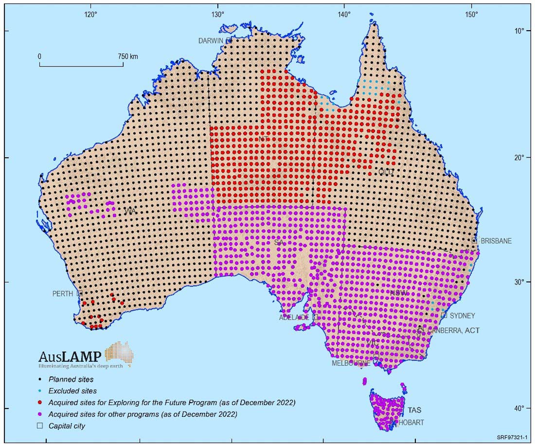
Figure 1. The progress of AusLAMP data acquisition. Black lines - state/territory borders for Western Australia (WA), Northern Territory (NT), Queensland (QLD), South Australia (SA), New South Wales (NSW), Victoria (VIC) and Tasmania (TAS)
Data accessibility
Time-series data, processed data, inversion products and reports will be released progressively throughout the project. The data and associated products are freely available to the public, scientific research organisations and industry. Figure 2 is an example of a recently released AusLAMP model, showing the electrical conductivity structure at a depth of about 36 km in the Northern Territory and western Queensland (Duan et al., 2021; Jiang and Duan, 2020; Doublier, 2020).
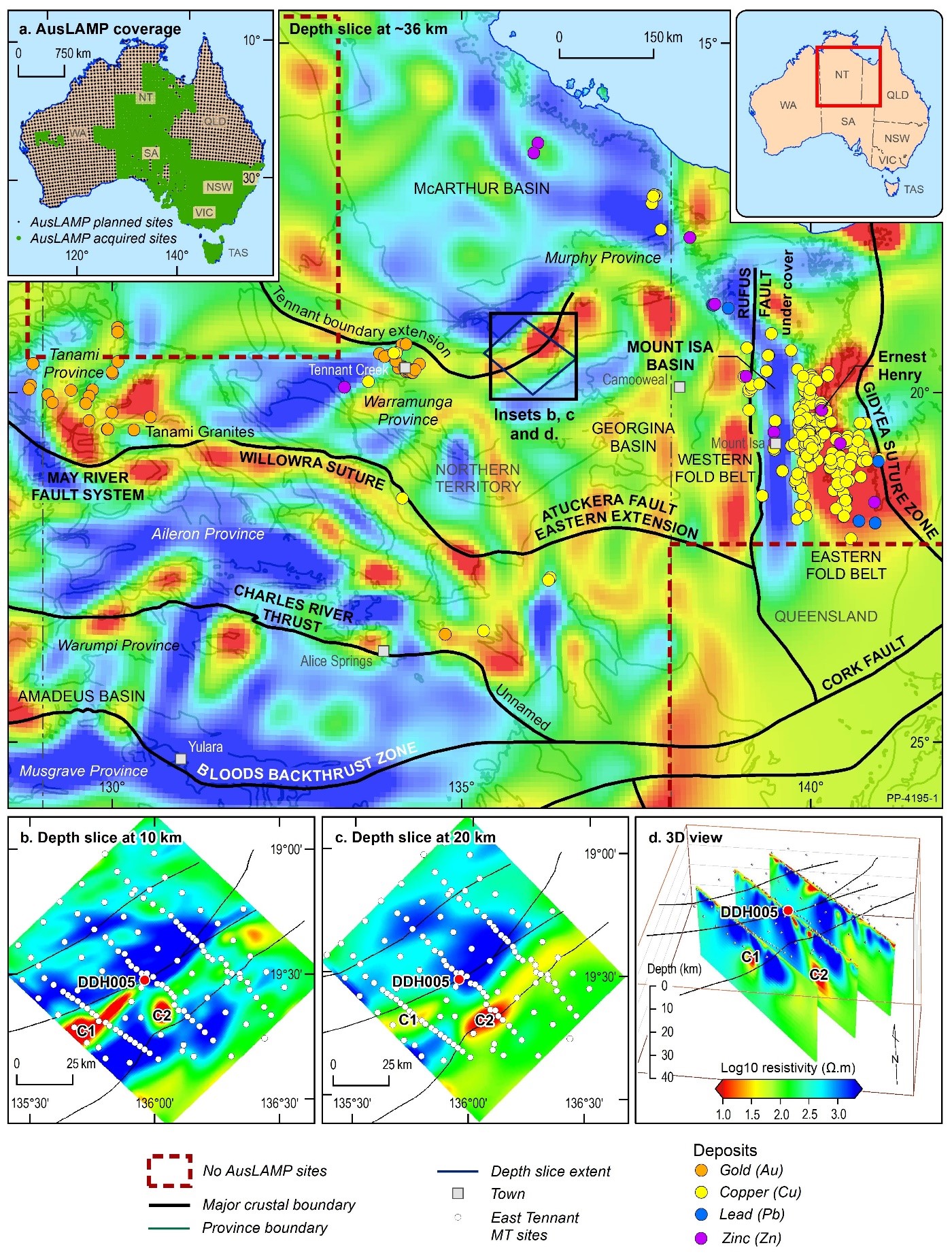
Figure 2. (main map) AusLAMP resistivity model at ~36 km depth overlain by major geological provinces (Duan et al., 2021). Gold/yellow dots: gold/copper occurrences; black lines: major crustal boundaries (Doublier, 2020); dashed boxes: no AusLAMP stations. (a) AusLAMP sites. Green: data acquired; black: data acquisition planned. (b–c) East Tennant resistivity model ~10 km and ~20 km depth slices. (d) Vertical sections show conductors extending from lower crust to near surface (Jiang and Duan, 2020). Black lines: major faults interpreted from seismic and potential-field data; white dots: MT stations; red dot: drillhole DDH005; C1, C2: conductors
AusLAMP land access
AusLAMP requires Geoscience Australia, its collaborators and contractors to access sites on various landholdings, including farms, national parks and Indigenous lands. Prior agreement to access these sites is always sought through consultation with landowners, traditional owners and other relevant stakeholders.
Geoscience Australia acknowledges the landholders and communities who have supported our work in rural, regional, and remote Australia to produce AusLAMP datasets.
AusLAMP partners
AusLAMP is a collaboration between Geoscience Australia, state and Northern Territory geological surveys, universities and other research organisations.
- Geological Survey of New South Wales
- Northern Territory Geological Survey
- Geological Survey of Queensland
- Geological Survey of South Australia
- Mineral Resources Tasmania
- Geological Survey of Victoria
- Geological Survey of Western Australia
- University of Adelaide
- University of Tasmania
- University of Western Australia
- AuScope
AusLAMP in detail
AusLAMP is a long-period MT survey that images the electrical conductivity structure of the Australian continental lithosphere in three dimensions (3D) and aims to identify and characterise major geological structures in the crust and upper mantle. The survey results provide new insight and valuable information for the Australian continental lithosphere framework and address fundamental questions, such as how the current geological structure was established, the nature of the geological processes, and how large-scale crustal and lithospheric structures control mineral deposition and hydrocarbon basin formation.
- Watch an animation on How MT surveys work
The survey results can be integrated with other national datasets, such as aeromagnetic, gravity, seismic tomography, geochemical, and geological datasets. The integration of these multidisciplinary datasets will help to develop a better scientific understanding of the lithospheric architecture and evolution of the Australian continent, highlighting prospective areas for mineral and energy resources at a regional scale, as well as to assess geoelectric and other geological hazards.
Magnetotelluric method
Magnetotellurics is a passive geophysical technique that measures naturally occurring variations of the Earth's magnetic and electric fields to derive the electrical resistivity distribution of the subsurface. Different types of MT instruments – audio, broadband and long-period – acquire data in different frequency ranges, giving an overall investigation depth of tens of metres to hundreds of kilometres. MT source fields are generated by worldwide thunderstorm activity (mainly lightning discharges at frequencies above 1 Hz) and the interactions between the solar wind and the Earth's magnetic field in the magnetosphere and ionosphere (at frequencies less than 1 Hz). These sources provide a rich spectrum of magnetic-field variations in the band 10-5 to 104 Hz, which are suited for crust and upper-mantle studies. These signals vary in strength over hours, days, weeks and over the solar cycle.
The time-series measurements of the magnetic and electric fields are converted to a set of frequency responses through Fourier transformation – the lower the frequency the deeper the source of the Earth response. In order to image the deep crust and upper mantle it is necessary to measure very low frequencies to achieve sensitivity to the base of the lithosphere. Using these data, a 3D Earth electrical conductivity model can be generated by sophisticated mathematical inversion algorithms on high-performance computers.
The MT method is widely used for mineral, petroleum and geothermal exploration, and in studies of the crust and mantle. The main strengths of the method are that it allows a broader range of investigation depths than other geophysical techniques, and it has a greater level of sensitivity to lateral and vertical electrical conductivity variations. It is useful for distinguishing different rock types and helping to understand geological structures and tectonic evolution.
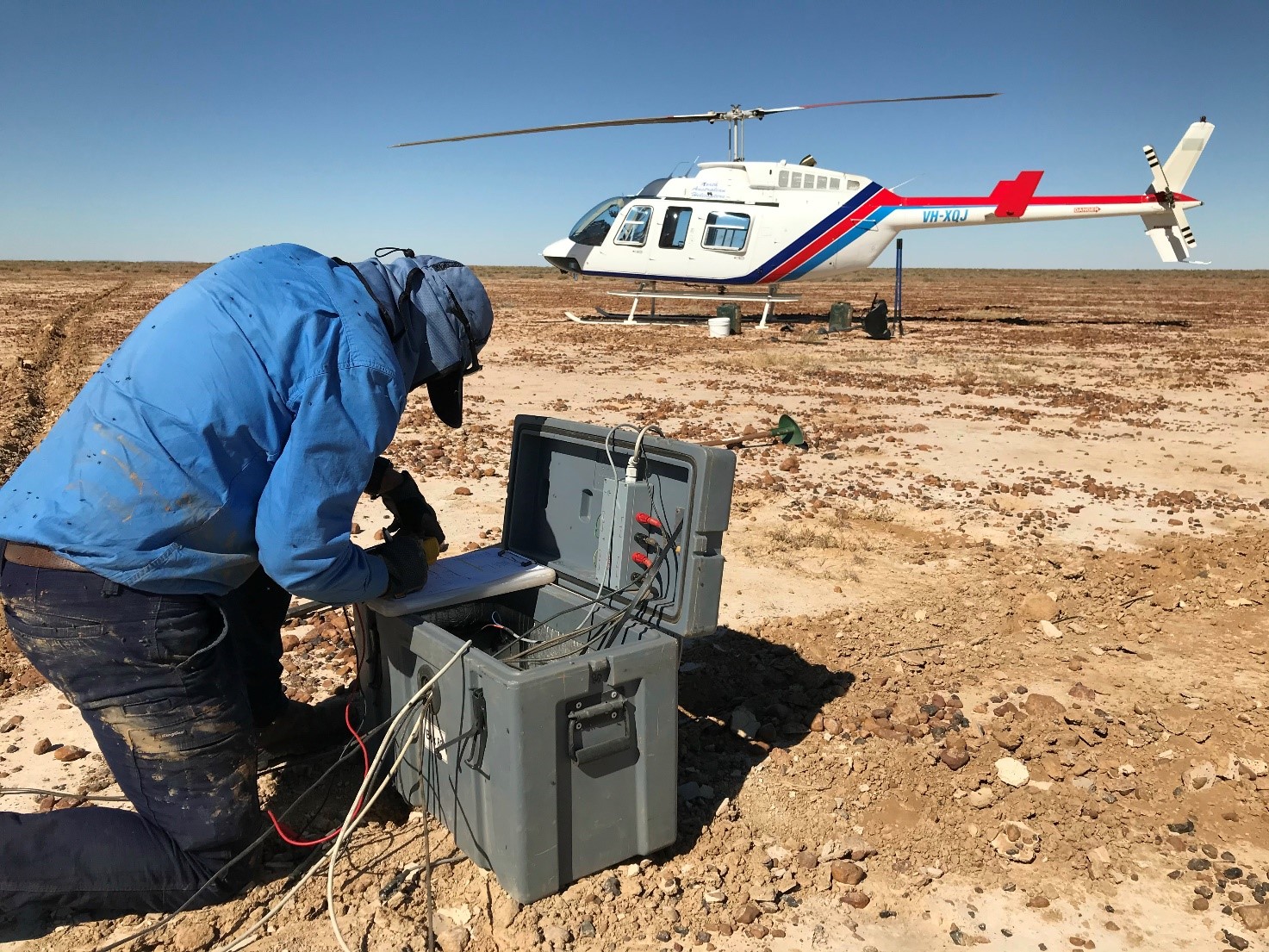
Figure 3. AusLAMP equipment being deployed in western Queensland
AusLAMP data acquisition
An AusLAMP survey collects long-period MT data using portable instruments on a grid of approximately 55 km (half-degree geodetic). AusLAMP instruments include a 3-component fluxgate magnetometer and dipoles with electrodes to record continuous magnetic and electric signals in the field. AusLAMP surveys target signals in the range 10s–20,000s, which is an investigation depth from a few kilometres to hundreds of kilometres. To ensure the MT measurement captures sufficient natural signals at longer periods, data is collected for 4-6 weeks at each site. Multiple stations are recorded simultaneously for the purposes of remote reference processing that improves the quality of processed data.
AusLAMP acquisition box and solar panels
Deployment sites are in open areas approximately 100 x 100 m in size, away from human-made noise sources such as houses, electric fences, power lines and major roads.
The deployed instruments comprise:
- an acquisition box containing a data recording unit, GPS and 12 volt battery
- 4 electrodes buried 50 cm deep and spaced 100 m apart on north-south and east-west axes – each electrode is connected to the acquisition box with a cable and, where required, the cable is buried
- 3 magnetic sensors (within a single magnetometer) buried 50 cm deep and connected to the acquisition box by a 20 m cable, which is also buried
- a small solar panel mounted close to the acquisition box to charge the battery.
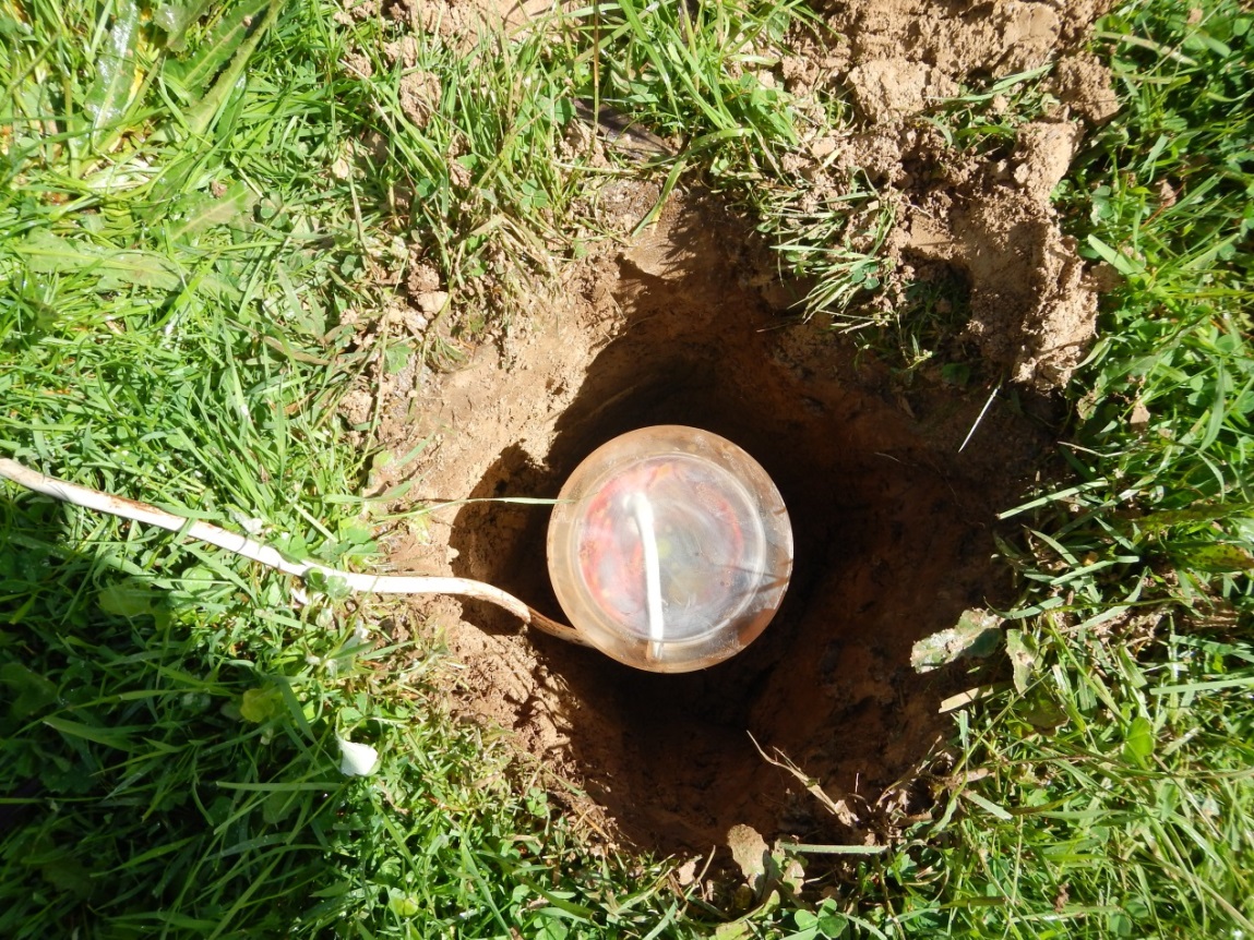
Figure 4. A magnetic sensor (magnetometer) used to measure the magnetic field
Outputs
Duan, J. 2019. Resistivity model derived from magnetotellurics: AusLAMP-TISA project. Geoscience Australia, Canberra.
Duan, J. 2021. Electrical resistivity structures and mineral prospectivity from Exploring for the Future AusLAMP data (2016-2019) in northern Australia. Record 2021/021. Geoscience Australia, Canberra.
Duan, J. 2022. Lithospheric resistivity structures and mineral prospectivity from AusLAMP data in northern Australia. Geoscience Australia, Canberra.
Duan, J., Kyi, D. 2018. Australian Lithospheric Architecture Magnetotelluric Project (AusLAMP): Victoria: Data Release Report. Record 2018/021. Geoscience Australia, Canberra.
Duan, J., Kyi, D., Jiang, W., Costelloe, M. 2020. AusLAMP: imaging the Australian lithosphere for resource potential, an example from northern Australia. Geoscience Australia, Canberra.
Duan, J., Kyi, D., Hitchman, A., Jiang, W. 2023. Resistivity structures derived from AusLAMP magnetotellurics data in Queensland. Geoscience Australia, Canberra.
Kirkby, A.L. 2020. Correlation between lithospheric resistivity and gold deposits in southeast Australia: statistical and geological significance. Geoscience Australia, Canberra.
Kirkby, A.L. 2020. Resistivity model of the southeast Australian mainland from AusLAMP magnetotelluric data. Geoscience Australia, Canberra.
Kirkby, A., Czarnota, K., Huston, D.L., Champion, D.C., Doublier, M.P., Bedrosian, P., Duan, J., Heinson, G. 2022. Lithospheric conductors reveal source regions of convergent margin mineral systems. Geoscience Australia, Canberra.
Kyi, D., Duan, J., Kirkby, A.L., Stolz, N. 2020. Australian Lithospheric Architecture Magnetotelluric Project (AusLAMP): New South Wales: data release. Record 2020/011. Geoscience Australia, Canberra.
Kyi, D., Duan, J., Jiang, W., Hitchman, A., Stolz, N., Taylor, G., Matthews, S., Aleksovski, T. 2023. Australian Lithospheric Architecture Magnetotelluric Project (AusLAMP) - New South Wales Time Series data release. Geoscience Australia, Canberra.
Musgrave, R. 2020. New AusLAMP 3D conductivity model supports tectonic interpretation in New South Wales. Geoscience Australia, Canberra.
Robertson, K., Kirkby, A.L., Thiel, S., Duan, J. 2020. Lithospheric resistivity model of the Delamerian Orogen from AusLAMP magnetotelluric data. Geoscience Australia, Canberra.
Further information
Onshore Seismic and Magnetotellurics Section
Mineral Systems Branch
Minerals, Energy and Groundwater Division, Geoscience Australia
Cnr Jerrabomberra Avenue and Hindmarsh Drive, Symonston ACT 2609
GPO Box 378, Canberra, ACT, 2601, Australia
Email: clientservices@ga.gov.au