Broken Hill Exploration Initiative Project
Page last updated:8 April 2016
This project concluded 30 June 2000.
Project description
The Broken Hill Exploration Initiative (BHEI) was a collaborative project conducted under the auspices of the National Geoscience Agreement (NGA) and was carried out jointly by Geoscience Australia, the New South Wales Department of Primary Industries (NSWDPI), the predecessor of the Geological Survey of New South Wales, and Department for Manufacturing, Innovation, Trade, Resources and Energy. It commenced in 1994 with a view to securing the long term economic prosperity of the city of Broken Hill in New South Wales and Port Pirie in South Australia, both of which faced an uncertain future following industry predictions that the Broken Hill ore body would be exhausted within 10-12 years.
The BHEI was a multidisciplinary project, bringing together high-resolution potential field data with regional geology, petrophysics, petrology, geochronology, geochemistry, seismic and radiometric data, structural analysis and metallogenesis studies to provide new insights into the geological evolution of the Broken Hill-Olary region. The combination of these disciplines and datasets would help to establish a firmer and more effective basis for mineral exploration. BHEI work programs and geological research was undertaken in both New South Wales and South Australia, along with a joint Geoscience Australia-PIRSA project which aimed to better understand the structure and geological setting of mineralisation in the Olary Domain.
One result of the collaboration with PIRSA is the Broken Hill Exploration Initiative - Ameroo Hill GeoPDF, within the Olary 1:100 000 mapsheet.
Deep Seismic Reflection Surveys
In 1996-97 a consortium consisting of Geoscience Australia, the New South Wales Department of Primary Industries - Mineral Resources and the Australian Geodynamics Cooperative Research Centre acquired 294.6 kilometres of explosive (dynamite) source deep seismic reflection data in the Curnamona Province in New South Wales eastwards from the South Australian border to the Darling Basin (Broken Hill Exploration Initiative: abstracts of papers presented at fourth annual meeting in Broken Hill, October 19-21, 1998). In 2003-04, another consortium consisting of PIRSA, the Predictive Mineral Discovery Cooperative Research Centre (pmd*CRC) and Geoscience Australia used vibroseis vehicles to acquire 198 kilometres of deep seismic reflection data in the Curnamona province in South Australia from the New South Wales border to the Flinders Ranges (The 2003-04 Curnamona province seismic survey: Workshop notes).
In 2005, the New South Wales Department of Primary Industries - Mineral Resources and Geoscience Australia combined to acquire a high resolution deep seismic reflection profile approximately 12 kilometres long immediately to the east of Broken Hill. The energy source was vibroseis vehicles and the new seismic profile followed the route taken by the 1996-97 Broken Hill deep seismic reflection profile 96AGS-BH1B, which was acquired using a dynamite source. The high resolution survey was designed to provide a high resolution seismic image of the uppermost part of the crust across an economically important area along strike from the world class Broken Hill lead-silver-zinc deposits using modern acquisition equipment and processing techniques. A brief outline of this survey can be found in Broken Hill Exploration Initiative: Abstracts for the September 2006 Conference.
Much of the copper-gold and lead-silver-zinc mineralisation in the southern part of the Curnamona Province is located at, or close to, the contact between two regionally extensive metasedimentary sequences. The lower of these sequences, which is highly sodium altered, is composed mainly of quartzofeldspathic rocks while the upper sequence is dominated by psammopelitic compositions (after Skirrow and Ashley, 2000).
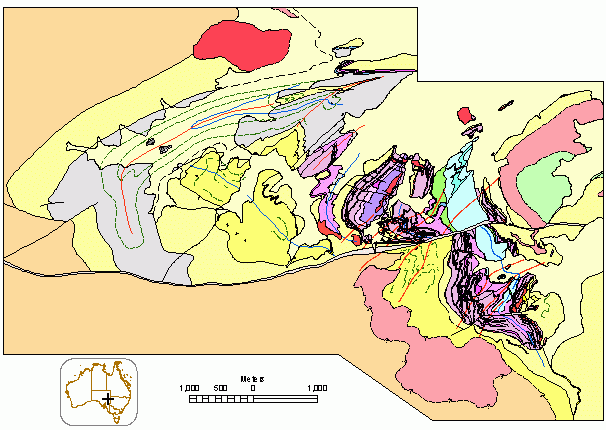
Interpreted geology from the Ameroo Hill online map

Copper-gold and lead-silver-zinc mineralisation in the southern part of the Curnamona Province
Outcome
Enhanced exploration strategies for, and promotion of, the Curnamona province as an area of copper-gold and lead-zinc mineral potential through increased understanding of the regional structure and stratigraphy of the Olary sub-domain.
Outputs
- geological map and report documenting the structure, distribution and stratigraphy of key rock units for part of the Olary Domain, including the heavily sulphidic Bimba Formation
- papers and presentations of BHEI results at conferences and seminars to promote and stimulate interest in the Curnamona Province as an area with further mineral potential.
Key results
- new structural mapping and BHEI seismic reflection profiling has provided evidenced that, contrary to previous expectations, major shear zones in the Broken Hill region dip southeast rather than northwest. Although re-activated during younger events (eg. Delamerian orogeny), most of these structures retain their original geometry and form part of a D3 northwest-vergent fold and thrust belt. This fold and thrust belt was superimposed on an earlier episode of large-scale northeast-vergent recumbent folds (D2), which, in turn, overprint an earlier layer-parallel fabric of possible extensional origin. The recognition of deformational events (D2 and D3) with near orthogonal orientations has major implications for 3D representations of regional structure and stratigraphy in the Broken Hill-Olary region and the ability to predict accurately what occurs at depth. Re-activation of the D3 shear zones during the Delamerian Orogeny and younger events is supported by argon-argon (Ar-Ar) ages ranging from 500-400 Ma.
- the principal copper-gold (molybdenum) deposits and prospects in the Olary and Broken Hill Domains are epigenetic-syntectonic, early Mesoproterozoic or late Paleoproterozoic in age and share several characteristics of iron-oxide associated copper-gold systems in the Mount Isa Inlier and elsewhere. Stable isotope studies demonstrate a clear difference in sources of fluids in copper-gold mineralisation and regional syntectonic sodium-calcium-iron alteration which formed at deeper crustal levels. Deposit styles range from copper-sulfide and iron-oxide rich to gold rich with sparse iron-oxides. Such variations have implications for exploration methodologies applied in the region.
- mineralisation in the Broken Hill-Olary region is, in part, structurally controlled. Examples of shear-hosted mineralisation occur at Copper Blow south of Broken Hill (copper-gold) while farther north in the Allendale region lead-zinc-silver mineralisation is contained within the regional D3 fabric. Less easily determined is whether lead-zinc-silver mineralisation, including the main Line of Lode, is structurally controlled also or whether it represent syngenetic/diagenetic mineralisation which was remobilised subsequently during later deformation and metamorphism.
- sensitive high-resolution ion microprobe (SHRIMP) geochronological studies undertaken on zircons from rocks of volcanic and sedimentary origin in the Olary and Broken Hill Domains indicate a maximum depositional age for the Willyama Supergroup of around 1710-1715 Ma while the youngest part of the sequence (upper Paragon Group) can be no older than 1642 ± 5 Ma. These data invite comparisons with the Mount Isa Inlier and McArthur Basin of northern Australia where Paleoproterozoic sequences of similar age were deposited in similar intra-cratonic settings. The results suggest that the stratigraphically higher parts of the Willyama Supergroup may be prospective for Mount Isa style mineralisation. Dating of a post-D3 granite (1591 ± 5 Ma) gives a minimum age for the cessation of major regional deformation (D3) and metamorphism
- collaborative SHRIMP uranium-lead dating program with the Australian Geodynamics CRC was concluded successfully. Results indicate an episode of bimodal magmatism (granites and mafic intrusives) contemporaneous with sedimentation around 1710-1675 Ma.