Data Driven Discoveries Program – Adavale Basin
Page last updated:27 July 2026
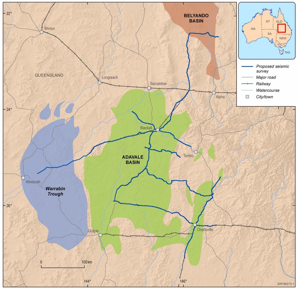
The $30.9 million Data Driven Discoveries Program, led by Geoscience Australia in collaboration with the Geological Survey of Queensland, has reprocessed decades old seismic data and collected new geoscientific data to support the acceleration of discoveries in the underexplored Adavale Basin in south-central Queensland.
In November 2025, the program successfully completed the Adavale Basin stratigraphic drilling project as part of its final phase of delivery, reaching a Geoscience Australia record total depth of 3,021 metres.
Occurring near the town of Blackall, the borehole from the stratigraphic drilling project provided 976 metres of Adavale Basin drill core, rock chips, groundwater samples, and comprehensive geophysical logs. These datasets will enhance chemostratigraphy across the Eromanga, Galilee, and Adavale basins, improve understanding of basin architecture, and provide critical insights into halite deposits to support future research into underground energy storage opportunities, including hydrogen.
This program supports the Australian Government’s Net Zero Plan, through researching opportunities for hydrogen storage, groundwater and minerals within the Adavale Basin and surrounding area. Providing companies and governments with vital information and modern precompetitive data to help secure the region’s prosperity and strengthen Australia’s energy future.
Hydrogen storage
Hydrogen gas can be stored in very large quantities underground in human-created salt caverns. The Boree Salt deposit in the Adavale Basin is the only known thick salt accumulation in eastern Australia. However relatively little is known about its extent and size. The Data Driven Discoveries program will help further identify the location and extent of salt bodies within the Adavale Basin and their geological controls to support exploration and opportunities for potential storage.
Salt bodies are also a potential source of renewable geothermal energy. The thermal conductivity of salt makes it an excellent medium for storing and transmitting heat, which can be used for power generation. However, more investigation is needed to fully understand the extent and size of salt bodies in the Adavale Basin, as well as their geological controls, before their potential for renewable energy can be fully realised.
Minerals
The identification and development of critical mineral resources is increasingly important as demand for renewable energy technologies and electric vehicles continues to grow. Basin systems like the Adavale Basin can host a variety of critical minerals, including copper, zinc and cobalt, which are critical to produce wind turbines and electric vehicle batteries. The Data Driven Discoveries program’s deep crustal seismic data will help to identify potential areas of mineralisation and provide valuable information on the size, shape, and depth of mineral deposits.
Groundwater
Reprocessed and new seismic data can be used to help understand distribution of aquifers and aquitards in the subsurface. Through the stratigraphic drilling project the Data Driven Discoveries program was able to sample deep groundwater resources for the first time to help understand composition and connectivity of groundwater resources. This combined information will allow for a better understanding of the hydrogeological properties of the area, such as groundwater flow and storage, and can aid in the management and sustainable use of groundwater resources.
Hydrocarbons
The Adavale Basin is a proven hydrocarbon basin, hosting the producing Gilmore Gas Field. However, the basin is still not well understood and remains underexplored. This made it challenging to identify and develop additional hydrocarbon resources, both conventional and unconventional.
The new seismic data acquired through this program provided valuable insights into the geological structures and properties of the Adavale Basin. Knowledge of geological structures helps to identify potential reservoirs and traps for hydrocarbon deposits and improves our understanding of the controls on hydrocarbon generation and trapping, for both conventional and unconventional resources. By using the new seismic data, geologists can better understand the subsurface geology of the Adavale Basin and identify areas of potential hydrocarbon accumulation. This can lead to the discovery of new hydrocarbon resources, which can support energy security and economic growth in Australia.
The Adavale Basin is a large and relatively old basin which was deposited in the Devonian period from approximately 419 to 358 million years ago. The Adavale Basin is buried under the younger Galilee Basin and does not out crop or appear at surface. This made it challenging to study the basin's geology and understand its properties and potential resources. Reflection seismic data allowed Geoscience Australia to image the basin and make predictions about its hidden geology. Drilling a stratigraphic well allowed Geoscience Australia to test these interpretations and models.
Seismic reflection data is one of the most valuable techniques to use in basins to infer the location of resources and provides a unique insight into basin architecture and basin evolution. Seismic reflection data involves generating sound waves that are sent into the subsurface and then recording the reflected waves that bounce back to the surface. By analysing these reflected waves, geologists can construct detailed images of the subsurface geology and identify salt bodies for hydrogen storage, potential hydrocarbon reservoirs, mineral deposits, and groundwater resources. Geoscience Australia has combined new and reprocessed legacy seismic to better understand the geology of the Adavale Basin. This has led to more accurate interpretations of the subsurface geology and a better understanding of the potential resources in the basin.
Reprocessing of legacy or “old” seismic reflection data for new geological insights
Reprocessing seismic data involved taking legacy or vintage seismic data from surveys conducted in the past and applying recent technological advances to further reduce the noise in the data and improve imaging of the subsurface. The Data Driven Discoveries program reprocessed approximately 2,350 kilometres of seismic data from the Adavale Basin acquired between the 1960s and 1980s. Although not modern acquisition, the reprocessing provided a tangible uplift in data quality and improves our geological understanding and helped us to decide where to acquire the new modern seismic acquisition.
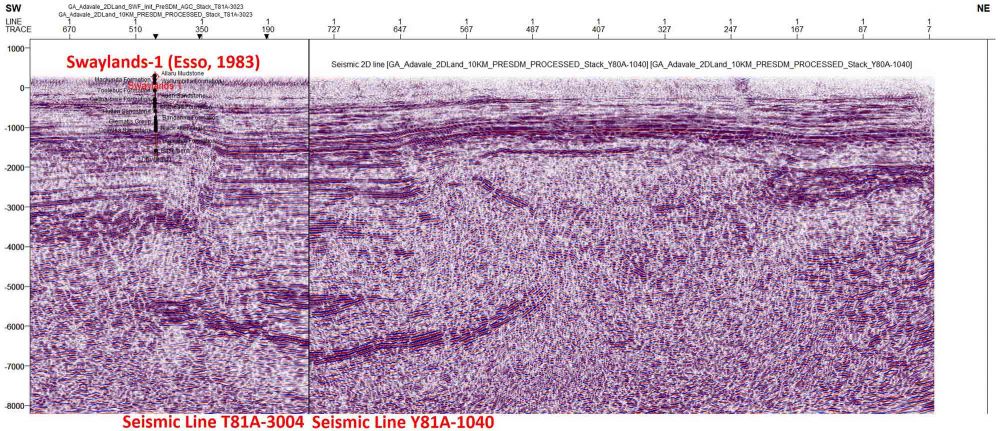
An example of a reprocessed seismic section
New modern seismic reflection acquisition to further improve geological knowledge
Geoscience Australia conducted a deep 2D crustal reflection seismic survey in south-central Queensland in 2023 to map potential mineral, energy, groundwater and hydrogen storage resources. Reflection seismic data is also used to map the geology and structure of the Earth. The data from this new survey was used to learn more about how the Australian crust evolved throughout geological time.
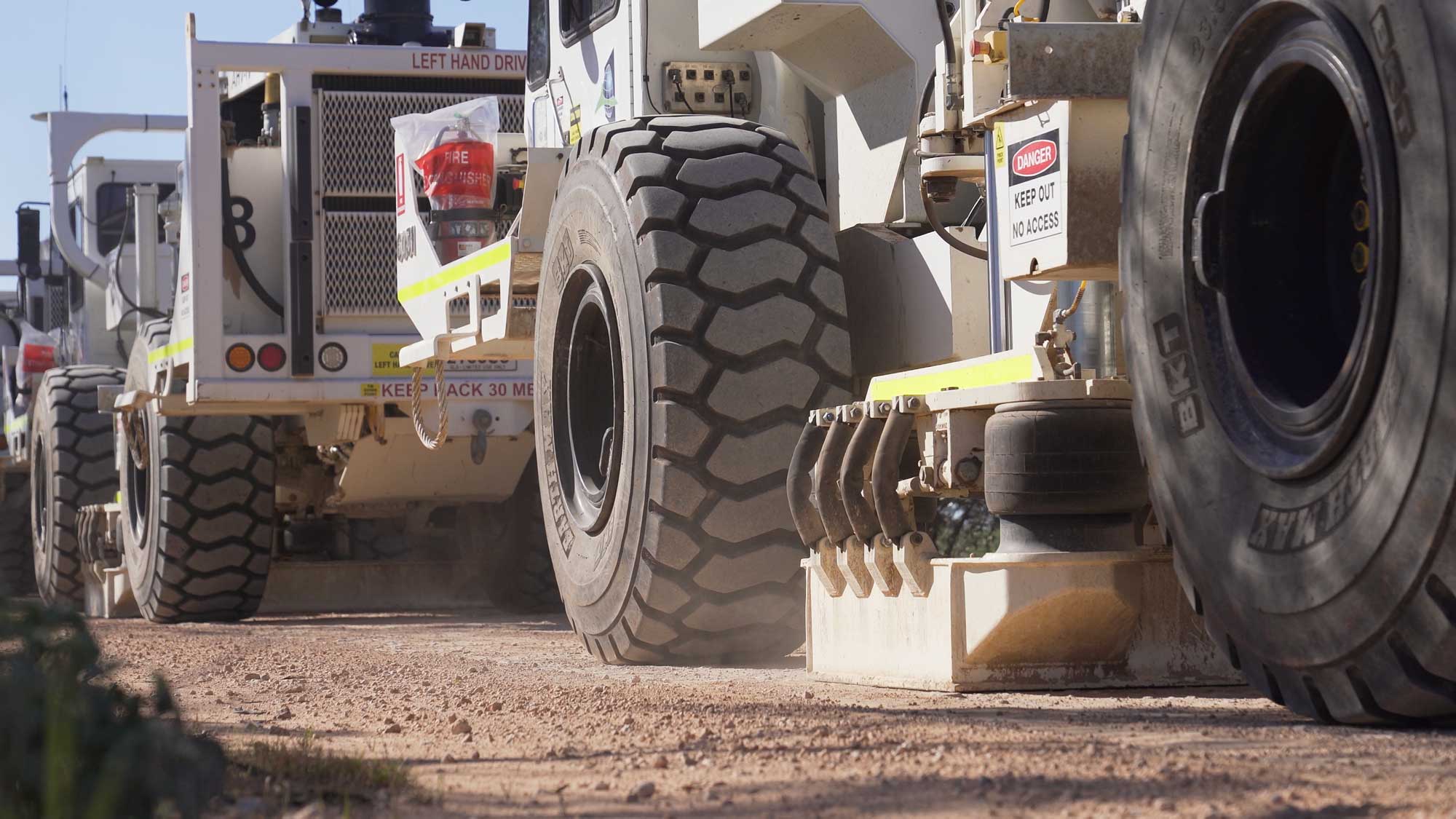
Seismic acquisition survey conducted in 2023
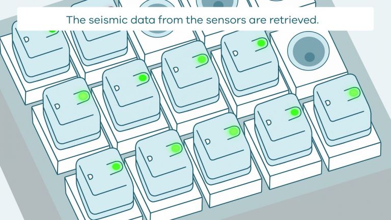
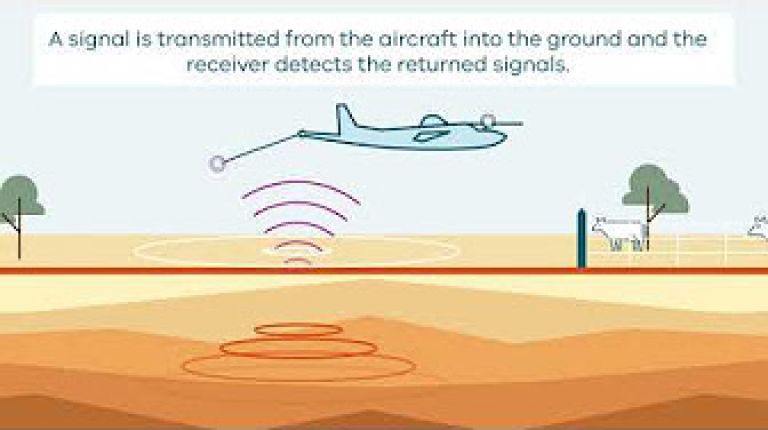
A reflection seismic survey is carried out using Vibroseis trucks. The trucks are fitted with heavy vibrating plates that send seismic (sound) waves into the ground, which then bounce off underground rock layers in the Earth. The reflected signals are recorded back at the surface by small sensors called geophones, placed at regular intervals along the survey line. The reflection data from all the geophones is then extracted, processed and then combined to create an image of the Earth.
The use of Vibroseis trucks for seismic surveys has several advantages over other methods. Firstly, it is non-invasive and very similar to a medical ultrasound scan, and the seismic waves cause no damage to infrastructure or the environment. Secondly, it can cover large areas efficiently, making it suitable for regional studies, such as the Adavale Basin survey.
A reflection seismic survey involves 10 to 15 4WD vehicles, 3 to 4 Vibroseis trucks, and a large recording truck to retrieve and process the information from the geophones. The trucks travel slowly, on the edge of the road, and only need to traverse along the road once. The truck’s vibrations sound and feel like a road train passing by.
A seismic survey crew can include up to 40 people. Support vehicles travel separately and can include trucks, 10 to 15 caravans that make a mobile camp for the seismic crew, a water tanker, mobile water treatment plant and other equipment used at camp sites.
Once the raw reflection seismic data is acquired it is processed using a range of advanced algorithms and techniques to enhance the quality of the data, remove noise and other interference, and generate detailed images of the subsurface structures and features. These images provide valuable information about the composition, thickness, and orientation of the geological formations in the Adavale Basin. The processed seismic data is also used to generate interpretations and models of the subsurface. These models allow geologists to visualise the subsurface in greater detail and make more accurate predictions about the geology.
The publicly available seismic data serves as a valuable resource for researchers and scientists who are interested in understanding the geological history and evolution of the basin. By studying the seismic data, they can gain insights into the tectonic processes that have shaped the basin over millions of years and the various geological events that have occurred within it.
Drilling to discover the hidden geology of a buried basin
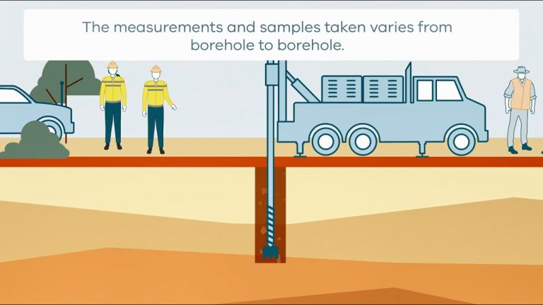
Drilling is used to characterise and sample rocks that are hidden under cover of geologically younger sedimentary basins and weathered material at the surface. Drill core and rock chips collected from boreholes are used to describe and analyse the covered, hidden geology. Techniques include rock geochemistry, petrology, pore fluid chemistry, interpreting structures and measuring geological ages. Downhole geophysical data is also collected from the boreholes and are used to map rock types away from the borehole to improve geophysical models. The data acquired from boreholes can be used to assess mineral and groundwater potential.
A drill site was identified through the seismic surveys undertaken in 2023, and the seismic reprocessing and chemostratigraphy undertaken in 2022 and 2023. Drilling was conducted using either a rotary mud or wireline coring method to recover rock chips or continuous drill core. The footprint of the ground disturbance for drilling operations was a cleared pad of approximately 130 by 130 metres, and required a mud sump to be dug, approximately 40 by 17 metres in size and up to 3.5 metres deep. Operations ran 24 hours a day, 7 days a week, supported by a small portable camp and support equipment including 4WD vehicles and trucks.
Drilling was carefully supervised and monitored to avoid disturbance to surface water and aquifers, and all sites are rehabilitated after drilling according to best practice and Queensland regulation.
Chemostratigraphy to correlate geological units across the basin
In order to establish a correlation across the rock layers of the Adavale Basin, chemostratigraphy using whole rock inorganic geochemistry was undertaken on core from existing wells. Previous attempts to correlate the Devonian-aged rock layers have been hindered by factors such as shallow drilling, structural complexities, and limited rocks of similar age and type to use as references on the surface in central Queensland. A new chemostratigraphic study has been undertaken to overcome these challenges and establish regional correlations across the basin to further understand the layered geology in the Adavale Basin. This technique was used to interpret the new seismic data acquired in the program and provided further information to identify the drilling site.
With a national airborne electromagnetic survey to learn more about the region’s near-surface groundwater and geology
Geoscience Australia carried out an airborne electromagnetic (AEM) survey over the Adavale Basin in 2024 to map near-surface aquifers and any geological structures like folds and faults that may be associated with the deeply-buried Adavale Basin. Undertaken as an extension to the nation-wide ‘AusAEM survey’, the AEM survey method detects minute changes in the electrical conductivity of minerals and groundwater in the Earth and is used to construct a geo-electrical model of the Earth. Once validated, these data are used to map geology and mineral and groundwater resources. A survey aircraft flew east-west flight lines at about 20 km line spacing across the broader Adavale Basin area. Closer to the GA Enniskillen 1 borehole the aircraft flew 5 km-spaced flight lines and along the paths of some of the Geoscience Australia seismic lines. Flight lines went between existing water bores and old exploration boreholes to help validate the AEM data and better map the near-surface geology down to about 200 m depth.
You can learn more about the AEM survey method by visiting Geoscience Australia’s Airborne electromagnetics web page and by watching the animation below.
Flying an airborne gravity gradiometry survey to measure the Basin’s deeply buried rocks
Geoscience Australia carried out an Airborne Gravity Gradiometry (AGG) survey across the eastern part of the Adavale Basin in 2024. The AGG method measures minute variations of the Earth’s gravity field, which correspond to changes in density due to different rock types and geological structures like faults beneath the surface. A survey aircraft flew 1 km spaced east-west flight line across a major fault line that forms the eastern boundary of the Adavale Basin. The data allowed us to better map the Adavale Basin margin and will be used in the future to assess any potential halite (rock salt) resources in the Adavale Basin.
You can learn more about the AGG survey method by visiting Geoscience Australia’s gravity web page.
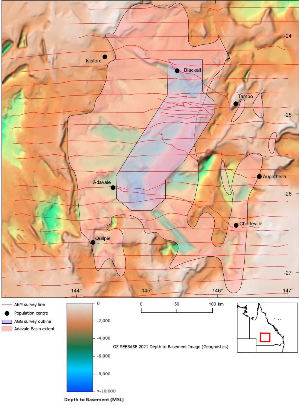
Location of airborne gravity gradiometry and electromagnetic surveys flown in 2024
Learn how seismic surveys work.
Watch an animation on how AEM surveys work.
Learn how stratigraphic drilling works.
The stratigraphic drilling program was conducted by Geoscience Australia’s contractors under Queensland Government legislation to ensure all operations complied with environmental, cultural and workplace health and safety requirements. The borehole was rehabilitated and sealed after drilling to ensure that there could be no damage to important aquifers in the Great Artesian Basin and Galilee Basin.
Community and stakeholder engagement
Geoscience Australia staff and selected contractors contacted landholders, local government, First Nations Groups and other agencies throughout the program. Measures were taken to mitigate against impacts to farm activities, the environment and cultural heritage. Local government and other interested parties were further engaged after drilling operations to answer questions and inform communities of drilling outcomes.
Partners
Geological Survey of Queensland
Data and products
| Dataset / Report | DOI |
|---|---|
| Drilling & Well Operations | |
| GA Enniskillen 1 borehole completion report: Adavale Basin stratigraphic drilling project (2026) | 10.26186/151218 |
| GA Enniskillen 1 coring services report (2026) | 10.26186/151166 |
| GA Enniskillen 1 mudlogging gas data package (2026) | 10.26186/151165 |
| GA Enniskillen 1 wireline log data package (2026) | 10.26186/151181 |
| GA Enniskillen 1 Modular Formation Dynamics Tester report (2026) | 10.26186/151237 |
| GA Enniskillen 1 daily geological report data package (2026) | 10.26186/151238 |
| GA Enniskillen 1 GeoGlide LWD-MWD dataset (2026) | 10.26186/151239 |
| GA Enniskillen 1 Newpark drilling fluids report (2026) | 10.26186/151240 |
| GA Enniskillen 1 WellPro cement program report (2026) | 10.26186/151241 |
| GA Enniskillen 1 daily drilling reports data package (2026) | 10.26186/151248 |
| Core, Lithology & Geological Logging | |
| Interpretation of HyLogger3 drill core and chips data – GA Enniskillen 1 (2026) | 10.26186/151163 |
| GA Enniskillen 1 core photography data package (2026) | 10.26186/151190 |
| GA Enniskillen 1 drill core lithological log (2026) | 10.26186/151234 |
| GA Enniskillen 1 drill chip magnetic susceptibility data package (2026) | 10.26186/151160 |
| GA Enniskillen 1 core spectral gamma data package (2026) | 10.26186/151161 |
| Geochemistry & Geology | |
| GA Enniskillen 1 drill chip pXRF data package (2026) | 10.26186/151162 |
| GA Enniskillen 1 water sample preliminary analyses data package (2026) | 10.26186/151180 |
| Application of elemental chemostratigraphy to refine the stratigraphy of the Adavale Basin, Queensland (2023) | 10.1071/AJ22108 |
| Defining a chemostratigraphic framework for the Adavale Basin – Inorganic and stable isotopic analysis of 10 petroleum wells from the Adavale Basin, Queensland (2023) | 10.26186/147773 |
| Seismic | |
| Data Driven Discoveries: Adavale Basin Deep Crustal Seismic Survey (L215). Data release with initial geological insights (2025) | 10.26186/150348 |
| L215 Adavale Basin 2D Seismic Survey (2024) | 10.26186/149289 |
| Adavale Basin 2D Reprocessed Seismic Data Package 2023 | 10.26186/149018 |
| Airborne Geophysics | |
| AusAEM, Northeast Queensland, Australia, 2024 Airborne Electromagnetic Survey TEMPEST® airborne electromagnetic data and GALEI conductivity estimates (2025) | 10.26186/150185 |
| Blackall Airborne Gravity Gradiometry Survey, 2024 | 10.26186/149789 |
Join our community
News and events
Find out the latest news, public talks and events and what’s happening in your community.
Get in touch
Have a question about Geoscience Australia or need help with using our data? Email us at clientservices@ga.gov.au or
call 1800 800 173.
Stay informed
Subscribe to some of Geoscience Australia's program newsletters to receive regular updates on, new data releases, publications, latest industry research and events.