Lord Howe Rise
Page last updated:10 October 2018
Geoscience Australia and the Japan Agency for Marine-Earth Science and Technology (JAMSTEC) are undertaking collaborative research based on a proposal accepted by the International Ocean Discovery Program (IODP) to better understand the geology of the central Lord Howe Rise (Figure 1).
Project Overview
The Lord Howe Rise (LHR) is an elongate ribbon of submerged and extended continental crust that separated from Australia during the Late Cretaceous (~74-52 million years ago). Present knowledge of the LHR geology is based on widely-distributed marine and satellite geophysical data, limited dredge samples, and sparse shallow (<800m below-sea floor) scientific drilling undertaken in the 1970s and in mid-2017.
Existing data provide a broad understanding of the LHR's crustal structure and sedimentary basin architecture. However, building more detailed knowledge of the LHR geology, and the geological evolution of the southwest Pacific more broadly, requires drilling into rocks that record the >100-million-year geological, tectonic and climatic history of the region. To this end, Geoscience Australia and JAMSTEC are leading an international effort to drill a deep stratigraphic hole on the LHR that will core Cretaceous and older (>65 million years) sediments and basement rocks.
A proposal for drilling up to 3500m below the sea floor into a LHR rift basin using the JAMSTEC drilling vessel CHIKYU was submitted to the IODP in October 2015. After peer review, the proposal was rated "excellent" by the IODP Science Evaluation Panel and, subject to funding, approved for implementation by the Chikyu IODP Board in early 2017.
The IODP deep stratigraphic drilling is supported by a program of data acquisition to define the geological framework of the proposed drill site(s) and to acquire the geotechnical data necessary to successfully drill a deep stratigraphic hole.
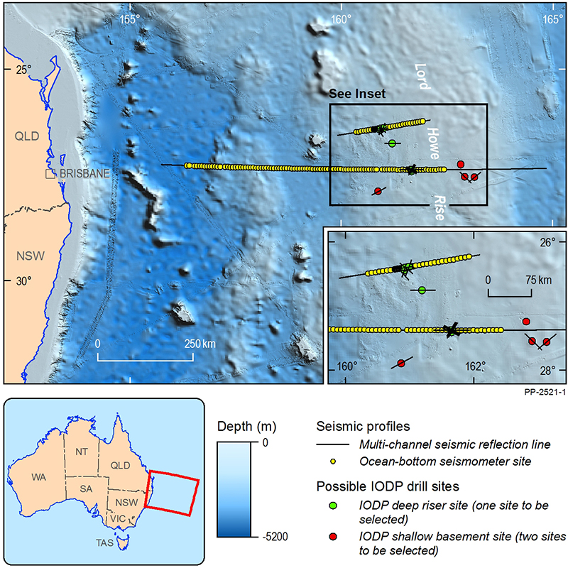
Figure 1. Lord Howe Rise Project study area, showing seismic lines acquired during the 2016 and 2017 site surveys and the locations considered in the IODP proposal for deep stratigraphic riser drilling and shallow basement drilling
Scientific Objectives
The objectives of the IODP deep stratigraphic drilling are to: 1) define the role and importance of continental crustal ribbons, like the LHR, in plate tectonic cycles and continental evolution; 2) recover new high-latitude data in the southwest Pacific to better constrain Cretaceous paleoclimate and linked changes in ocean biogeochemistry; and 3) test fundamental evolutionary concepts for sub-sea floor microbial life over a 100-million-year timeframe. These objectives are aligned with the IODP 2013-2023 Science Plan. In addition, the drilling will enable assessments of the regional resource potential of the LHR by contributing samples and data from its sedimentary basins.
A summary of the IODP proposal is available for download [PDF 59 KB].
Project Implementation
The Project commenced on 1 July 2015 and, if fully funded, will run for at least seven years. The project includes four main activities.
1. Deep Seismic Survey for Crustal Structure and Tectonic Framework (March-May 2016)
JAMSTEC and Geoscience Australia, together with participants from the University of Sydney and GNS Science (New Zealand), successfully completed the first of two pre-drilling site surveys on 11 May 2016. This seven-week survey acquired 2D seismic reflection data and seismic refraction data, recorded by 100 ocean-bottom seismometers, along an east-west transect across the LHR to map regional crustal structure (Figure 1).
Additional data acquired during the survey includes ~600 line km of high-resolution multi-channel seismic over the proposed drill sites (Figure 2), multibeam sonar bathymetry, sub-bottom profiles, gravity and magnetics. The survey also acquired acoustic data (via Passive Acoustic Monitoring) and marine fauna sightings data, as part of the mitigation to minimise impacts of seismic operations on cetaceans (see EPBC Referral 2015/7623). A report on the Seismic Survey is available for download from the JAMSTEC website. Survey data can be accessed via the Geocience Australia website (see below) and the National Offshore Petroleum Information Management System (NOPIMS).
2. Detailed Site Survey at Proposed Riser Drilling Site (November - December 2017)
In December 2017, JAMSTEC and Geoscience Australia successfully completed the Detailed Site Survey. The survey acquired sea floor imagery, high-resolution multibeam bathymetry, sub-bottom profiles, and sea floor samples (shallow piston cores) at the proposed drill sites. 2D seismic reflection data and seismic refraction data, recorded by 64 ocean-bottom seismometers was acquired along a 200 km single seismic line across the preferred drill site. The survey also acquired acoustic data (via Passive Acoustic Monitoring) and marine fauna sightings data, as part of the mitigation to minimise impacts of seismic operations on cetaceans (see EPBC Referral 2017/8027). The information from this detailed mapping and sampling will be used to understand the geotechnical properties of the seabed that affect drilling operations and to contribute to the environmental approvals process for the drilling project. These data will also contribute valuable baseline environmental information describing deep-water habitats in a remote area of Australia's maritime jurisdiction.
A report on the 2017 survey is available for download from the JAMSTEC website and data from this survey are expected to be made publicly available by early 2019.
3. Deep Stratigraphic Drilling
If funded, the proposed Deep Stratigraphic Drilling program will include a single deep hole designed to intersect the full stratigraphic succession in a LHR rift basin (Figure 2). A second priority is to drill one or two shallow holes into basement horst blocks. Drilling will incorporate full core recovery and extensive down-hole logging.
4. Processing and Storage of Data and Samples
All data and samples collected during the project will be made publicly available. Survey data will be available from the Geoscience Australia and JAMSTEC websites and from NOPIMS, while core samples will be accessible from the IODP. The archival portion of the cores will be located at Geoscience Australia.
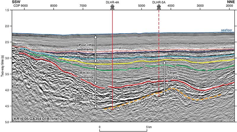
Figure 2. Example of processed seismic reflection data from the 2016 Deep Seismic Survey showing inferred geology and potential sites for deep stratigraphic drilling
Data and Publications
Data from Lord Howe Rise Deep Seismic Survey (2016) are available as follows:
- Seismic and other geophysical data (field and processed) are available from NOPIMS by searching for 'Lord Howe Rise GA0354 [KR16-05] 2D MSS'
- Processed multibeam bathymetry data are available for download from the Geoscience Australia website.
- Passive acoustic monitoring (PAM) data are available at cost of transfer by contacting ausgeodata@ga.gov.au.