Mineral Systems of Australia
Page last updated:8 April 2016
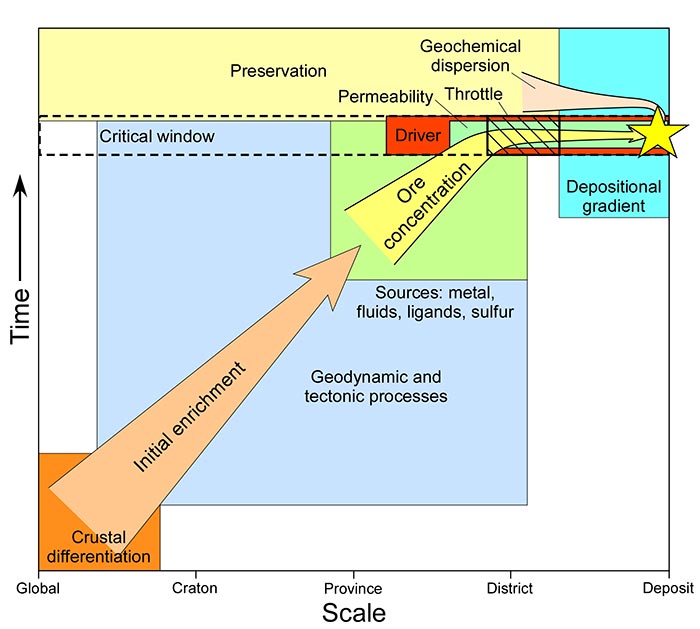
Mineral deposits are one very small, but economically important, part of a much larger geosystem, the mineral (or mineralising) system. Although the search for mineral deposits has some similarities to the proverbial "needle in a haystack", the signatures of mineral systems typically extend well beyond the mineral deposit and, as such, represent a much larger target for exploration. As approximately 80% of Australia is covered by younger basins and regolith that obscure many direct signatures of mineral deposits, the mineral system approach offers predictions and vectors that can reduce search areas and increase the effectiveness of exploration through cover.
The purpose of the Mineral Systems of Australia section is to assist the mineral exploration industry by documenting mineral systems and using this information to assess mineral prospectivity and encourage exploration under cover and in greenfields areas. The activities of Mineral Systems of Australia are guided by a combination of the relevance of commodities based on their importance to the Australian economy and their strategic importance, knowledge gaps, and expertise within Geoscience Australia.
Activities and results
Based on the criteria outlined above, the Mineral Systems of Australia section is undertaking three activities in 2012-13. These include an assessment of Australian salt lake systems for their potential to host lithium, potash and other non-traditional but strategic mineral resources, documentation of the spatial and temporal distribution of mafic-ultramafic magmatic events which may be prospective hosts to deposits of nickel, copper, chromium and platinum-group metals, and an assessment of the southern Aileron Province for iron oxide-copper-gold mineral systems.
Recent achievements
The Mineral Systems of Australia section is built upon mineral systems understandings developed by Geoscience Australia and others over the last fifteen years. Important recent results by section members that have relevance to current activities include:
- A Review of Australian Salt Lakes and Assessment of their Potential for Strategic Resources - The publicly available information on Australian Salt Lakes has been reviewed and mineral systems models were used to produce maps showing which lakes have the highest potential for lithium, boron, potash and calcrete-hosted uranium.
- Iron oxide-copper-gold potential of the southern Arunta Region - An assessment for IOCG mineral system potential has been undertaken in the southern Arunta Region, incorporating the southern Aileron and northern Warumpi provinces.
- A chapter entitled "Foundations of wealth Australia's major mineral provinces" in the book "Shaping a Nation: A Geology of Australia", which was prepared for the 34th International Geological Congress.
- Episodes Journal of International Geoscience March 2012 - Australia through time: a summary of its tectonic and metallogenic evolution - A paper on timing and links between metallogenesis and the tectonic evolution of Australia.
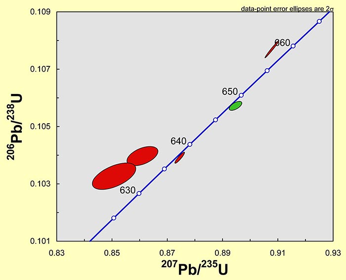
- The age of the Telfer Au-Cu deposit and its relationship with granite emplacement, Paterson Province, Western Australia - a Professional Opinion reporting the ages of the Telfer gold-copper deposit, the nearby O'Callaghans tungsten-copper-zinc skarn deposit and granites in the Paterson Province.
- A series of reports on the potential of north Queensland, east-central South Australia and the southern Northern Territory for various types of uranium systems, including uranium-rich iron oxide-copper-gold deposits.
- Uranium mineralisation events in Australia - a report on the ages of uranium deposits in Australia.
- Uranium mineral systems: Processes, exploration criteria and a new deposit framework - a report summarising important aspects of uranium mineral systems.
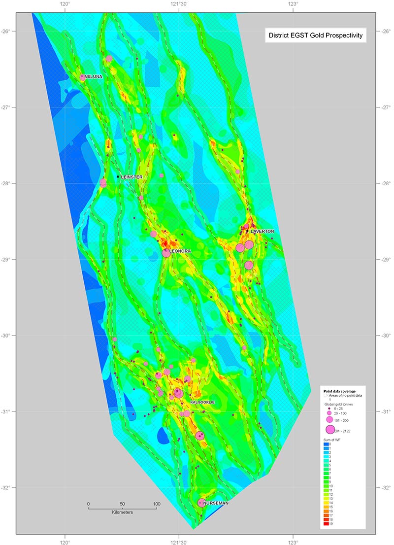
- Predictive mineral discovery in the eastern Yilgarn Craton: an example of district-scale targeting of an orogenic gold mineral system - a paper published in Precambrian Research (2010) on target generation using a gold mineral system approach in the Eastern Goldfields Superterrane in Western Australia.
- A comprehensive five part report on the gold mineral system of the Eastern Goldfields Superterrane.
- A comprehensive series of large-format maps and reports documenting mafic-ultramafic magmatism and large igneous provinces in Precambrian rocks of Australia.
Potential of Australian salt lake and associated groundwater systems for lithium, potash and other strategic minerals
Background
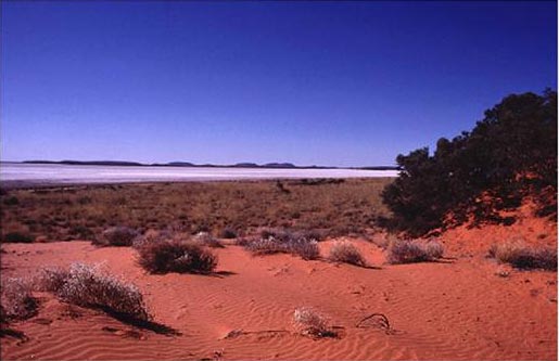
Salt lakes around the world are major sources of lithium and potash and possibly other strategic commodities. In particular, salares in the Atacama Desert of Chile, Peru, Argentina and Bolivia contain most of the world's low-cost supply of lithium, and salt lakes in Jordan, Israel, and China are significant sources of potash. Despite having major salt lakes throughout much of central Australia, the Yilgarn Craton and western Victoria, public domain knowledge of saline lakes and their associated groundwater systems as potential sources for lithium, potash and other commodities is limited. The goal of this activity is to develop a mineral systems understanding for these saline lakes and to identify and assess, at a very broad scale, the salt lake systems with highest mineral potential.
Activities
- Develop models for a saline lake-groundwater mineral systems using known global systems (e.g., salares in South America) to determine the key factors that control mobility and concentrations of elements in groundwaters and the saline lakes, and factors that may cause deposition of metals into geological materials (e.g., lake sediments, rocks in the aquifer and the regolith). This analysis will also include an assessment as to which commodities in these systems can be sufficiently concentrated to be economically extractable.
- Collect data from the literature on the concentrations of commodities of interest in saline lakes and the associated groundwaters and geological materials in Australia.
- Use the mineral systems concept to predict which salt lake-groundwater systems in Australia could be economic sources of minerals.
- Undertake a gap analysis to determine data that are required for more detailed mineral potential assessment.
Products for 2012-13 Financial Year
A Geoscience Australia Record describing the salt lake mineral system, summarising literature data of salt lake brine composition, and predicting, at the continental scale, the potential of Australian salt lake systems to host resources of lithium, potash and possibly other commodities (June 2013). The mineral potential predictions will also be presented as a summary brochure documenting a preliminary mineral potential assessment using the salt lake mineral system model.
Proposed activities beyond June 2013
Compilation of existing data on salt lake systems will form the basis of a possible second stage of this activity in which Australian salt lake systems will be systematically sampled and studied to determine their potential for selected strategic commodities. This stage will include sampling and analysis of lake brines and sediments for strategic commodities and other chemical parameters (acidity, total dissolved solids, etc.) followed by drilling to document the associated hydrological system. The data will be combined with an understanding of salt lake mineral systems to provide detailed mineral potential assessments for lithium, potash and other strategic minerals. This activity, if it occurs, is expected to require three years commencing in July 2013.
Mineral systems related to mafic-ultramafic magmatism
Background
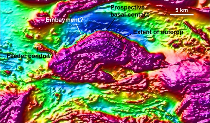
Between 2006 and 2009, Geoscience Australia's mafic-ultramafic magmatic events (MUM) project produced detailed maps and reports describing the distribution in space and time of Australian Precambrian mafic-ultramafic magmatism. These Australian maps were the first comprehensive magmatic maps published for any continent. The program revealed systematic patterns for the magmatic systems that are prospective for significant resources, particularly nickel-copper, but also platinum-group elements, chromium, scandium, vanadium and titanium. The known nickel/copper resources are well documented by recent reviews, but summaries of the other commodities are lacking, and fundamental data about the magmatic systems - especially their chemistries and mineral potential - are not yet available. The new project will add Phanerozoic terranes to the existing Precambrian map series and make the synthesis available as a GIS showing the distribution of mafic-ultramafic complexes throughout Australia. This will be the basis for future studies targeting specific mafic-ultramafic magmatic events for mineral potential assessment.
Activities
- Update existing Archean to Proterozoic mafic-ultramafic data into a national GIS coverage.
- Include within the national GIS coverage additional data on Phanerozoic mafic-ultramafic magmatic systems.
Products for 2012-13 Financial Year
A GIS dataset summarising the distribution, composition and age of mafic-ultramafic complexes throughout Australia (June 2013).
Proposed activities beyond June 2013
The comprehensive GIS, along with reports and data, will be useful for mineral exploration decisions. It will also serve as a basis for developing models of the mineral systems hosted by mafic-ultramafic magmatic rocks. This, in turn will provide the basis for national-scale analysis of platinum-group elements, nickel/copper, chromium and scandium mineral systems potential. At a wider scale, the continent-scale appraisal of mantle-derived magmatic events provides a fundamental framework for better understanding the tectonic development of the Australian continent.
Southern Aileron iron-oxide copper-gold province
Background
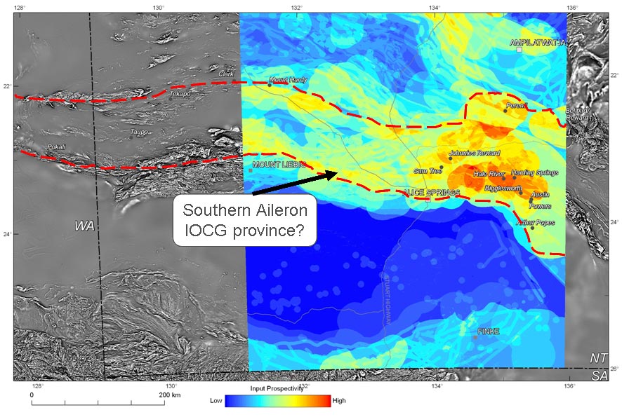
Mineral prospectivity analysis undertaken as part of a regional investigation into the Georgina-Arunta-Amadeus region of the southern Northern Territory has highlighted a zone of high prospectivity for iron oxide-copper-gold (IOCG) systems along the southern margin of the Aileron Province. This zone contains a number of copper-gold deposits that have been tentatively interpreted as IOCG deposits, including Jervois and Johnnies Reward and the recently discovered Bigglesworth, Austin and Powers prospects. The Tekapo and Pokali prospects appear to be within the western extensions of this prospective zone. The immediate goal of this research program is to extend the original mineral potential assessment to cover the entire southern Aileron Province, which extends from eastern Western Australia through the Northern Territory into western Queensland. Longer-term goals include a better understanding of the southern Aileron IOCG province and a national-scale mineral potential assessment of IOCG mineral systems.
Activities
- Extending IOCG mineral potential modelling to cover the entire Aileron Province.
Products for 2012-13 Financial Year
Summary document and maps on IOCG mineral potential analysis of entire Aileron Province.
Collaboration with other Geoscience Australia sections and outside organisations
The Mineral Systems of Australia section collaborates with other sections at Geoscience Australia. In 2012-13, collaboration includes construction of a solid geology for central Australia (Regional Geodynamic Framework), a review of strategic commodities from an Australian perspective (Mineral Promotions) and the development of construction of national-scale radiogenic (neodymium, lead and argon) isotope maps (Continental Geology).
We will also collaborate with outside organisations, including State and Territory geological surveys, CSIRO, exploration and mining companies and universities where appropriate. Research within the section and with internal Geoscience Australia and external organisations will be guided by research directions for minerals-related research advocated by the Australian Academy of Sciences in Searching the Deep Earth: A vision for exploration geoscience in Australia.
These collaborations will influence the direction of Mineral Systems of Australia and provide critical information for regional and national-scale mineral potential assessments.