Introduction of the North Pilbara 'Virtual' Structural Field Trip
Page last updated:8 April 2016
Rationale
Since 1995, Geoscience Australia, initially through its predecessor, the Australian Geological Survey Organisation, and the Geological Survey of Western Australia (GSWA) have been cooperating on a National Geoscience Mapping Accord (NGMA) project in the North Pilbara (Figure 1). Most of the 1:100 000 scale remapping has been conducted by GSWA, with Geoscience Australia chiefly focussed on assembling synthesis GIS datasets, examining Au and base-metal mineral deposits and examining tools for assisting mineral exploration in the craton. In gathering data for the synthesis, it became apparent that a comprehensive study addressing the complexity of the structural chronology, as well as the kinematics of shear zones and their relationship to mineral deposits, was needed.
This Record is a contribution to the North Pilbara NGMA project, and is a summary of the results of three field seasons of study into the structural chronology of the deformation and kinematics of some major shear zones in the Pilbara Craton (1997, 1998, 1999). The study extends from the Mosquito Creek Belt in the southeast to the coastal strip around Karratha and Dampier in the northwest. Significant time was spent mapping the Wodgina 1:100 000 Sheet area, hence the more lengthy treatment in this Sheet area (Figure 2). Observations were also made during GSWA organised field excursions in the west (1998) and around Marble Bar (1999).
Details of the field observations and structural data used in this Record, including many scanned photographs of field relationships may be found in the Geoscience Australia OZROX database.
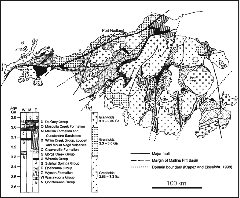
Figure 1. Geology and stratigraphy of the North Pilbara
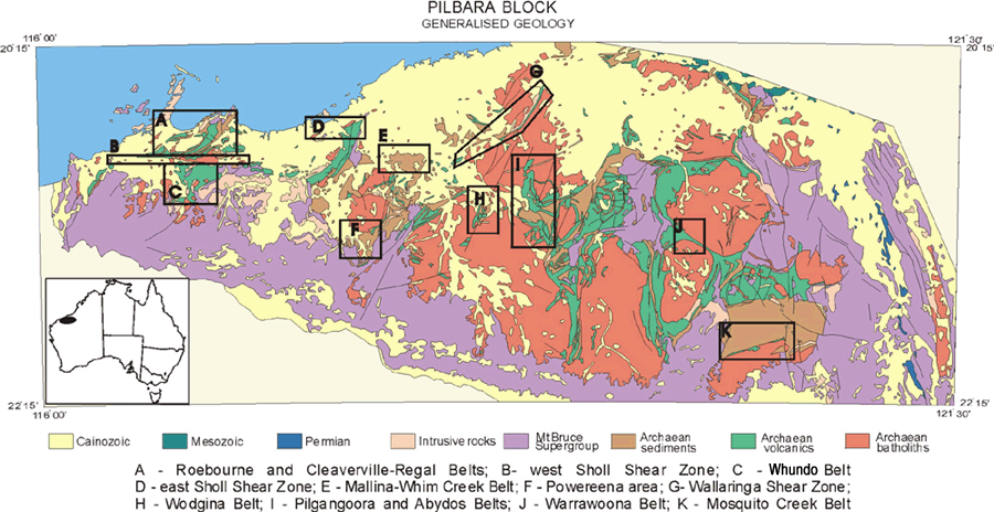
Figure 2. Simple geology of Pilbara Block
Comment
This Record is largely a description of the fabric elements from a number of representative areas across the Pilbara Craton. The result is an interpretative chronological framework for correlating structures (deformation events) across the Pilbara Craton. The methods used are classical structural geology techniques of recording and describing the sequence of overprinting relationships to build up a relative chronology or structural stratigraphy for each area. The deformation style and relative chronology is then combined with the latest geochronology where available to develop a Pilbara-wide framework (deformation events).
The degree of confidence in the correlation of deformational events across large areas is obviously fraught with potential errors. However, it is believed that simply documenting the structural history in small areas and not attempting to draw the results together does not get very far in understanding the tectonic evolution of the Pilbara Craton. This approach will inevitably have errors, but it is hoped that it will provide a suitable framework for further refinement.
Regional Geological Setting
The Pilbara Craton (Figure 1) is composed of the 3.6-2.8 Ga North Pilbara granitoid-greenstone terrane and the unconformably overlying volcano-sedimentary sequences (Mount Bruce Supergroup) of the 2.77-2.3 Ga Hamersley Basin (Blake, 1993). Hickman (1983) grouped the older volcano-sedimentary rocks into a single stratigraphic sequence - the Pilbara Supergroup. The Pilbara craton has been traditionally divided into a west and east, but, more recently, a central Pilbara has been defined (see Hickman, 1999). U-Pb zircon geochronology has played a major role in determining the tectono-stratigraphic evolution of the Pilbara.
Greenstones
The oldest greenstone rocks of the Pilbara include the ca. 3515 Ma, bimodal mafic and felsic volcanic Coonterunnah Group (Buick et al., 1995, Van Kranendonk and Morant, 1998), located around the southern margin of, and intruded by, the 3468±4 Ma Carlindi Batholith in the east Pilbara.
Elsewhere, the oldest exposed rocks consist of undated mafic-ultramafic volcanics at the base of the Warrawoona Group (Hickman, 1983) and conformably overlying felsic volcanic rocks of the 3472-3463 Ma Duffer Formation. These are in turn overlain by interbedded chert (Towers Formation), the Apex Basalt, and ca. 3458-3454 Ma felsic volcaniclastic rocks of the Panorama Formation, which all belong to the lower part of the Salgash Subgroup (Hickman, 1983). Conformably overlying the Panorama Formation in the North Pole Dome and the southeast of the Corunna Downs Granitoid Complex, and unconformably overlying the Coonterunnah Group, is the Strelley Pool Chert. The Strelley Pool Chert is a distinctive unit of silicified siliciclastic rocks and evaporites with common wavy to domal laminated structures of probable stromatolitic origin (Buick et al, 1995). Above this lies a thick section of ultramafic to basaltic, intermediate and rare felsic volcanic rocks of the upper part of the Salgash Subgroup. Barley et al (1998) have recently dated intermediate volcanic rocks, with TTG-like chemistry, from the McPhee dome and Kelly belt in the southeast Pilbara at 3430-3417 Ma.
The 3325 Ma Wyman Formation unconformably overlies the Warrawoona Group in the east Pilbara, and consists mainly of 0-1 kilometre thick porphyritic rhyolite flows, local tuff and basalt (Hickman, 1983).
In the west Pilbara, the oldest rocks sequences are the Roebourne Group (3270 Ma), which are found to the north of the Sholl Shear Zone (Hickman, 1997). The Roebourne Group consists of basalt and peridotite (Ruth Well Formation) overlain by banded chert, iron-formation and clastic metasedimentary rocks (Nickol River Formation). These are in thrust contact with the structurally overlying Regal Formation, an undated unit of pillow basalt, local cherts and basal komatiite.
In the east Pilbara, an unconformable sequence of komatiites, pillow basalts, and felsic volcanic rocks of the ca. 3240 Ma Sulphur Springs Group lie on the Salgash Subgroup. The Sulphur Springs Group is disconformably overlain by the Gorge Creek Group, which consists of a thick sequence of siliciclastic and chemical sediments, rarer felsic volcanic and volcaniclastic rocks passing into mafic volcanic rocks (Hickman, 1983).
In the east Pilbara, Hickman (1997) describes the 3120 Ma Whundo Group as consisting of 4 kilometres of basalt and minor ultramafic and felsic units (Nallana Formation), felsic calc-alkaline volcanics (Tozer Formation), pillow and massive basalt (Bradley Basalt), and rhyolite tuff and agglomerate (Woodbrook Formation).
An important marker unit for the Pilbara, the ca. 3020 Ma Cleaverville Formation stratigraphically overlies the Regal Formation (at least in the west) and consists of up to 1500 metres of BIF, chert, and fine clastic metasedimentary rocks (Hickman, 1983). The formation is found in east and west Pilbara, and both sides of the Sholl Shear Zone.
Unconformable on the Cleaverville, the 3015-3000 Ma bimodal volcanics of the Whim Creek Group forms the base of the Mallina Basin (Smithies et al, 1999). The Whim Creek Group consists of less than one kilometre of basalt and basal polymict conglomerate (Warambie Basalt), felsic tuff and epiclastic sediments (Cistern Formation) and komatiitic basalt and pillow tholeiite (Louden Volcanics). The 1000 metre thick flow-banded Kialrah Rhyolite lies with an unconformity on the Louden Volcanics and is dated at 2972 Ma (Hickman et al, 1998).
The De Grey Group (Hickman, 1983) of the Mallina, Mosquito Creek and Lallah Rookh Basins was deposited in ensialic rifts between around 3000 Ma and around 2940 Ma (Smithies et al, 1999). The De Grey Group lies unconformably on greenstone basement, and consists of conglomerate, and other coarse to fine grained clastic sedimentary rocks, high-Mg basalt and local felsic volcanic rocks.
Unconformable on the Pilbara Supergroup are the continental rift rocks of the Mount Bruce Supergroup of the Hamersley Basin (2780-2400 Ma). The Mount Bruce Supergroup consists of the mainly volcanic Fortescue Group, the mainly clastic-chemical Hamersley Group and the mainly sedimentary Turee Creek Group.
Granitoids
About 45% of the craton is made up of composite granitoid bodies called granitoid complexes or batholiths (Figure 3), which were formed by repeated intrusion generally into the centre of the complexes (Wellman, 1999). The granitoid complexes are elliptical to circular in plan and range in size from 25-110 kilometres in diameter, with centres spaced an average of 60 kilometres apart (Figure 4). This pattern extends across much of the craton and is expressed under cover by large gravity lows.
The oldest plutonic components are found in the east Pilbara, with the Warrawagine Granitoid Complex (3660 Ma), Carlindi Shaw and Yule Granitoid Complexes (3470-3450 Ma), made up of various tonalite-trondjhemite-granodiorite-granite (TTG) plutons and gneisses. These older components are intruded by voluminous ca. 3325 Ma granitoids, especially in the Mount Edgar and Corunna Downs Granitoid Complexes (Figure 3).
In the west Pilbara, the Karratha and Harding Granitoid Complexes were emplaced at ca. 3260-3250 Ma, slightly older than the 3240 Ma period in the Yule Granitoid Complex and Strelley Granite in the east. The Caines Well Granitoid Complex in the central Pilbara was intruded at ca. 3100 Ma, similar to ages for phases of the Chirratta Granitoid Complex (3115 Ma) which intruded the Whundo Group.
The Pilbara was then subjected to a prolonged, almost continuous, period of repeated magmatism between 3015-2920 Ma, with important pulses at 2950 Ma and 2935 Ma (Nelson et al, 1999). The latest so-called 'post-tectonic' Sn-Ta bearing granitoids intruded at ca. 2850 Ma in the east Pilbara and represent the final stages of cratonisation (Bickle et al, 1989).
Wellman (1999) was able to map increasing differentiation of granitoids by changes in gamma-ray response, with progressive intrusion of younger, more evolved, granitoids into older, less evolved granitoids. This secular change to more evolved granitoids (TTG to granites) was also noted in the central Pilbara (Champion & Smithies, 1999).
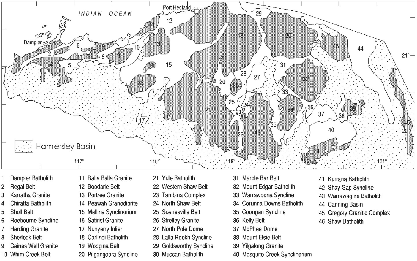
Figure 3. Hickman blocks
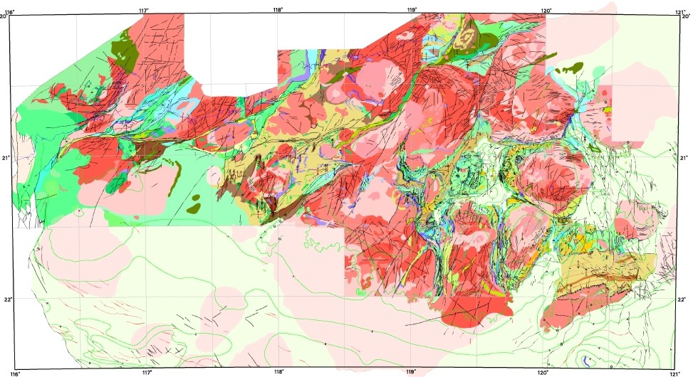
Figure 4. Solid geology map
Previous Structural Work
The only systematic structural work published for the entire Pilbara is Hickman (1983). Most workers before and since have tended to concentrate on either the west Pilbara or the east Pilbara. However, Krapez (1993) published a novel interpretation of the Pilbara-wide geodynamics which used a sequence-stratigraphic model, although this was largely not supported by detailed structural analysis across the whole craton.
The ca. 3.65-2.85 Ga Pilbara Craton is a classical example of a granite-greenstone-terrane (GGT), with ovoid to circular composite granitoid complexes separated by synformal, enveloping greenstone packages in the east and more linear granitoid-greenstone belts in the west (Figure 4). There is debate regarding the style of the tectonic processes involved in the formation of the Pilbara Craton i.e., whether plate tectonics operated in the mid Archean (cf. De Witt, 1998; Hamilton, 1998).
Contrasting models for the tectonics of the Pilbara specifically include:
- Alpine style crustal thickening followed by diapirism (Bickle et al, 1980; 1985)
- accretion of oceanic islands and island arc terranes (Krapez, 1993, Kiyokawa & Taira, 1998)
- modified core complex formation (Zegers, 1996; Zegers et al, 1996)
- strike-slip faulting (Krapez & Barley, 1987; Krapez, 1993)
- diapirism or vertical tectonics (Hickman, 1983; 1984; Van Kranendonk & Collins, 1998; Collins et al, 1998).
Because of a lack of data, most of the previously published structural geology and tectonic work in the Pilbara has not focussed on the third dimension. Wellman (1999) has modelled the third dimension and produced consistent results (seismic refraction, gravity, magnetics) which show that the granite-greenstone contacts are steeply dipping and extend to mid crustal levels of about 14 kilometres (Figure 5). These deep greenstone keels are unusual when compared to other Archean GGT, where depths are commonly less than 10 kilometres and generally around 5-6 kilometres (House, 1996, table 6.3). Such a crustal geometry has important implications for the tectonics of the Pilbara. Another factor to consider is the radiogenic heat production by the granitoid rocks themselves, a factor considered important for the Proterozoic (see Sandiford et al, 1998; Hand et al, 1999). Radiogenic heat production may have thermally softened the crust and upper mantle, which has important implications for crustal strength, deformation style and basin (greenstone) formation.
The structural geology of the Pilbara craton is complex. The first tectonic events are at least as old as ca. 3.5 Ga, and they continued to affect the Pilbara Craton throughout the mid and late Archean. The Pilbara Craton was influenced by Proterozoic orogenesis, with the ca. 2200 Ma Opthalmia orogeny, the ca. 1800 Ma Capricorn (Baramundi) orogeny, and the Proterozoic Paterson orogeny reworking in the east. Repeated extensional reactivation through the Paleozoic of the marginal mobile belts in the northwest Pilbara craton was responsible for the development of the Northern Carnarvon Basin (Gartrell, 2000). Activity today is recorded by recent earthquakes, especially in the Marble Bar region.
The Pilbara Craton has developed at least 11 packages of greenstone (many separated by regional unconformities) and at least 12 punctuated magmatic events (Figure 6). It is therefore not surprising that the rocks of the Pilbara have a polyphase history of deformation events.
In terms of cross Pilbara studies, Hickman (1983) provides a long lived, four-phase deformation chronology (largely followed by Van Kranendonk, 1997; 1998 in more local studies), with:
- interfolding of greenstone and granitic material, granitic intrusion and migmatisation
- main deformation involving solid state diapirism, greenstones down and granitoid up, during greenschist to amphibolite metamorphism
- conjugate folding and faulting associated with regional E-W compression, and later faults produced by N-S compression
- (more localised) tight to open folding about subhorizontal axial planes.
In this study, a five-phase chronology of deformation events, with a number of discrete events identified within each phase (more than 13 events), has been developed. This scheme is modified from previously published tables (eg, Blewett & Huston, 1999), which allows for flexibility (events can be added or deleted without disrupting the numbering system), and more closely follows the long-lived 'phases' of Hickman (1983).
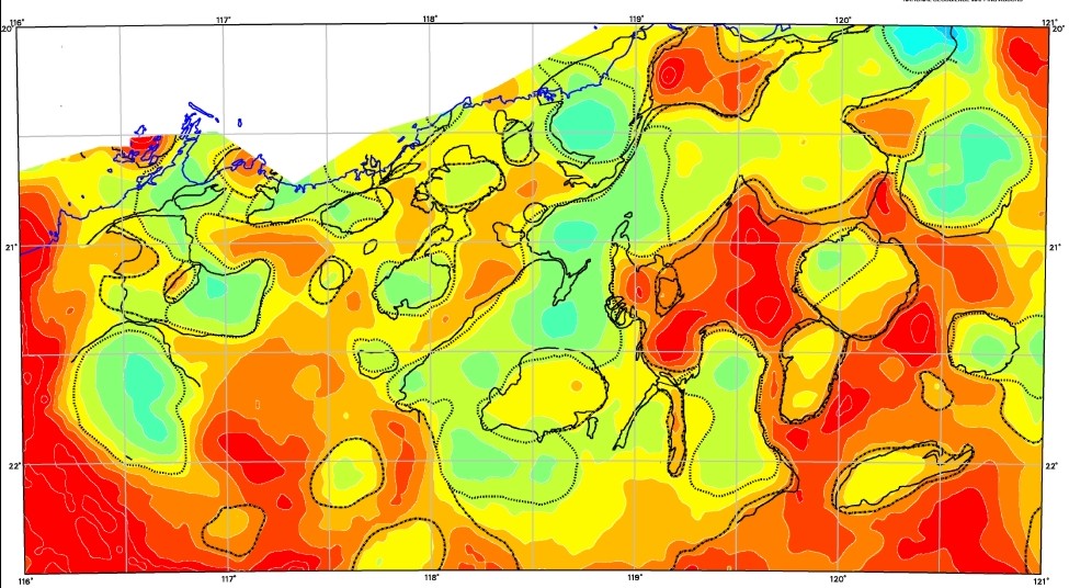
Figure 5. 3D shape
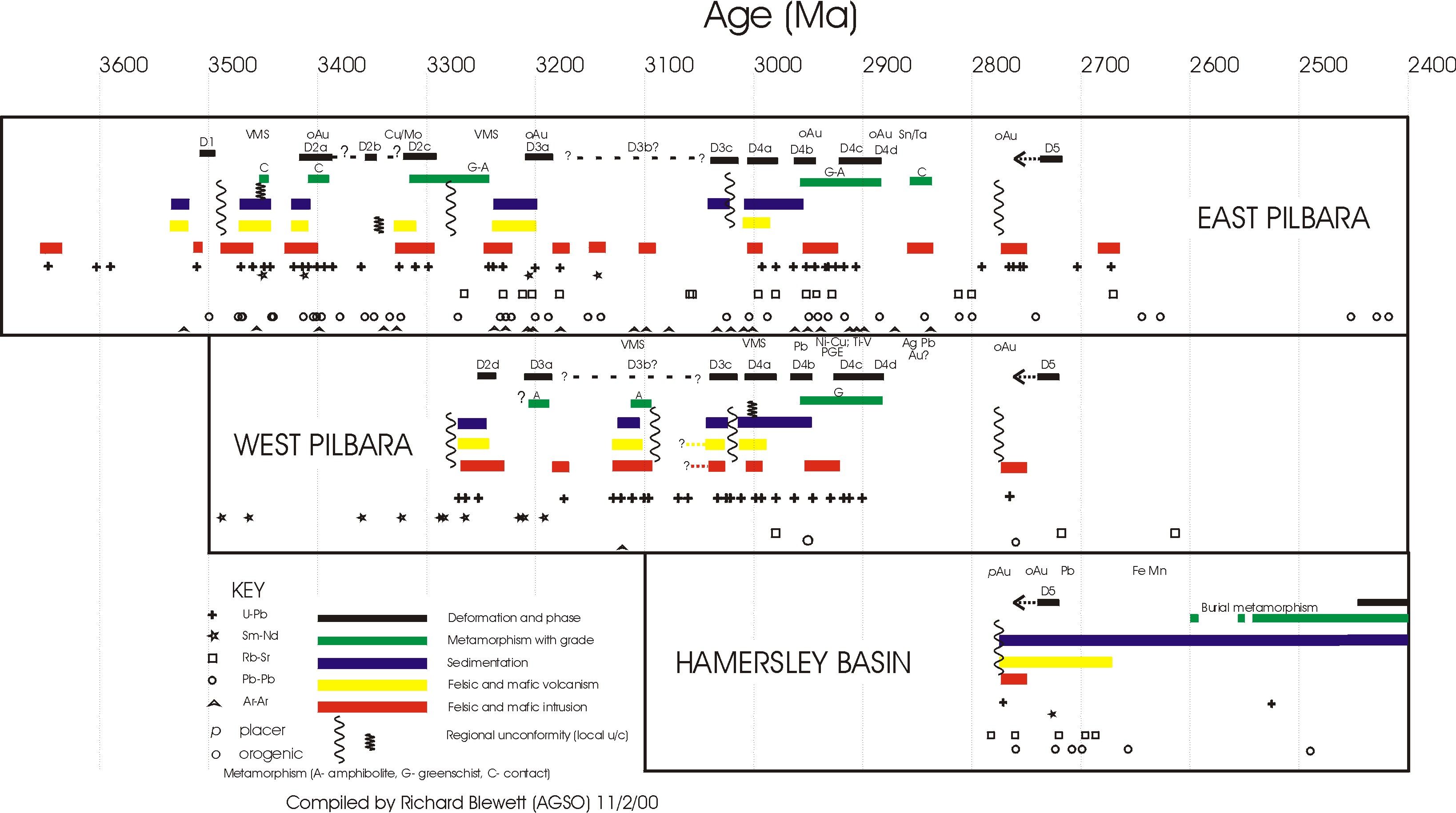
Figure 6. Magmatic events