Onshore Petroleum Project
Page last updated:8 April 2016
Overview
Australia hosts numerous producing hydrocarbon provinces, most of which are located offshore. Only the Cooper-Eromanga region operates as a major onshore oil and gas producer, delivering hydrocarbons to markets in Queensland, New South Wales and South Australia. Although many new significant gas discoveries have been made in recent years, it is widely acknowledged that Australia's oil production has been in steady decline since the late 1990s, and that increasing amounts of liquid hydrocarbons are needed to satisfy the continued demand.
In the context of declining oil supply, the Australian Government provided Geoscience Australia with funding for the Onshore Energy Security Program (2006-11). The purpose of this program is to supply pre-competitive data and information to stimulate exploration in under explored areas. In addition to petroleum, the Onshore Energy Security Program also involves the assessments of uranium, thorium, and geothermal resources. As part of this initiative, the Onshore Petroleum Project focuses primarily on those sedimentary basins which may have potential for oil and gas, but are predominantly frontier regions in terms of exploration for petroleum. Recognising the underexplored status of such regions, a staged program of new data acquisition was carried out.
Taking an innovative approach, project work includes the utilisation of new regional potential field data and the acquisition of several deep seismic surveys in order to image basement features which exerted a controlling influence on basin architecture and tectonic evolution. Under guidelines outlined in the National Geoscience Agreement, Geoscience Australia worked with the State and the Northern Territory Geological Surveys to develop a deep seismic acquisition program with specific line kilometres devoted to potential petroleum provinces. Seismic signals down to 20 seconds TWT have been recorded and processed, allowing the entire upper crust to be imaged. With respect to hydrocarbon occurrences, basinal sections (3-6 seconds TWT) will be delineated, permitting the interpretation of architectural relationships with basement terranes, prevailing structural styles and the effects of tectonic overprints on the basin-fill successions. This latter aspect will highlight the potential for hydrocarbon preservation subsequent to orogenic phases.
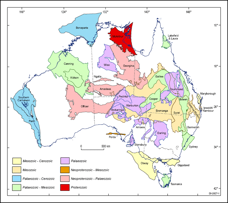
Distribution of onshore sedimentary basins
Status
Initial work on data acquisistion began in 2006 with the Mt Isa Survey, 06GA-M6, that imaged the Burke River Structural Zone of the Georgina Basin in Queensland, as well as data over the Mt Isa and Lawn Hill Platforms. This was followed in 2007 by the acquisition of more data in queensland that included the 07GA-IG1 sesimic line that discovered the previously unknown Millungera Basin.
The first seismic survey with a predominant petroleum focus was acquired in March 2008 and January 2009 over the Rankins Springs and Yathong troughs of the Darling Basin in western New South Wales. The Yathong Trough exceeds 7000 metres in thickness, with the basin-fill being Silurian-Devonian sedimentary rocks. These successions potentially contain several source rock intervals and are therefore deemed to be highly prospective with respect to petroleum. The survey filled an existing data gap and enabled the preliminary imaging of source rock occurrences, stratigraphy, and structure of the sedimentary fill of the southeastern Darling Basin.
Acquisition of the Gawler-Curnamona-Arrowie seismic survey occurred in mid 2008, and mainly evaluated the geothermal and uranium potential in the basement provinces of central South Australia. A distinct petroleum component of this survey was provided by a line across the southwest Arrowie Basin, where oil shows have been recorded in Cambrian sedimentary rocks, in the 1950's.
Another regional survey in South Australia and the southern Northern Territory was acquired in late 2008, and consisted of a seismic traverse across the southwestern Arckaringa Basin, the eastern Officer Basin and terminated in the southern Amadeus Basin well to the north of the southern basin margin. The Officer Basin is Neoproterozoic to Devonian in age and, based on numerous oil shows, is known to host four petroleum systems. The most prolific of these is associated with a carbonate-playa sequence within the Marla overthrust zone, where thick salt horizons could provide an effective regional seal.
The Amadeus Basin, like the Officer Basin, contains a Neoproterozoic to Late Devonian sedimentary section which reaches a maximum thickness of about 14 kilometres. Five petroleum systems have been identified previously, with the Palm Valley gas field and the Mereenie oil and gas field producing from Ordovician reservoirs and providing energy to consumers in the Northern Territory. Recent analyses of live oil bleeds collected from the Finke-1 well suggest that a 50 metre oil column is preserved at this location. It has been concluded that this oil was derived from Neoproterozoic sources, confirming that these geologically old sedimentary rocks are indeed capable of generating petroleum.
In 2009, a seismic survey of the Georgina Basin-Arunta Region consisting of 373 line kilometres was collected to evaluate the area's petroleum and uranium potential. Data collected in 2011 include the western Officer and Southern Carnarvon Basins in Western Australia. Both are prospective for hydrocrbons with known source rocks and petroleum systems.
Achievements
Modern seismic data provide greatly improved imagery of the subsurface, leading to a better understanding of basin fill successions and geological structures. From this, the likely distribution of source rocks, their maturity levels and their preservation potential may be interpreted. A key result will be to gain insights into the likely effects of regional orogenic events on the stratigraphic architechture. The new data is being made available to industry to assist current and future explorers in their efforts to unlock the untapped hydrocarbon potential in these frontier regions. It is anticipated that the results of these surveys will help drive a new exploration phase in onshore Australia and will lead to a synthesis of the onshore hydrocarbon potential.
Several products from the Onshore Petroleum Project are now available:
More than 4000 kilometres of seismic data have been collected from 2006 to 2011 for the Onshore Energy Security Program:
Table title goes here
| Year | Location |
|---|---|
| 2011 | Southern Carnarvon (WA) - 259 km to identify petroleum and geothermal energy systems of the Byro Sub-basin of the onshore Carnarvon Basin, Western Australia. |
| 2011 | Yilgarn-Officer-Musgrave (WA) - 487 km to evaluate and to assess hydrocarbon potential of the western Officer Basin in Western Australia. |
| 2009 | Georgina-Arunta (NT) - 373km to evaluate petroleum and uranium systems in the Georgina Basin and Arunta Inlier. |
| 2009 | Curnamona-Gawler link (SA) - 145km to image relationship between the Curnamona Province and Gawler Craton, and architecture of Neoproterozoic - Cambrian sedimentary rocks in the Adelaide Rift System. |
| 2008 | Gawler-Officer-Musgrave-Amadeus (SA-NT) - 634km to identify uranium, petroleum and geothermal energy systems: eastern Officer Basin and the Southern margin of the Amadeus Basin. |
| 2008 | Curnamona-Gawler-Arrowie Survey (SA) - 60km to assess uranium, petroleum and geothermal energy systems of the Arrowie Basin. |
| 2008 | Rankins Springs (NSW) - 230km to assess unexplored troughs in the South East Darling Basin for hydrocarbon potential. |
| 2007 | Mt Isa-Georgetown-Charters Towers (Qld) - 1400km to identify uranium, petroleum and geothermal energy systems: Millungera and Eromanga-Carpentaria Basins. |
| 2006 | Mt Isa (Qld) - 900km to identify uranium, petroleum and geothermal potential: Burke River Structural Zone of the Georgina Basin |
Seismic data used in the Onshore Petroleum Project is available at the Seismic Acquisition and Processing Project web page.
Bowen, Gunnedah and Surat Basins
In 2009, a series of papers on the "Evolution of the Bowen, Gunnedah and Surat Basins, eastern Australia" was published as a thematic issue in the Australian Journal of Earth Sciences, and represent a summary of the results of a previous Onshore Sedimentary Basins project.
A 3D geological model of the architecture of the Bowen, Gunnedah and Surat Basin system has been constructed.