Hydrogeological data discovery and delivery
Page last updated:23 February 2023
Ongoing project
Overview
Geoscience Australia develops data products for all its hydrogeological projects. As part of the international research community, we support FAIR data principles (data that is Findable, Accessible, Interoperable and Reusable). Groundwater data products are published through a range of standard channels in line with our commitment to continually improve delivery of our work. Additionally, Geoscience Australia collects multipurpose datasets such as geophysics and geology that are useful for a range of hydrogeological users, which we also publish through these channels.
- The Geoscience Australia portal highlights specific data themes that are likely to be useful for groundwater science. The portal includes tools to visualise and download a broad range of data.
- Geoscience Australia’s Product Catalogue, allows users to download data and publications by searching keywords.
- Web services deliver data in a variety of protocols including Open Geospatial Consortium (OGC) and Esri mapping and imaging services. A webpage enables users to find relevant services.
- Some of the data from recent collaborative projects between Geoscience Australia and DAWE, CSIRO, BOM such as the Bioregional Assessment program (BA) and the Geological and Bioregional Assessment program (GBA) are published through the Australian Government’s website.
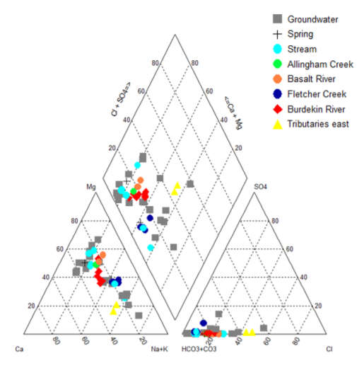
Hydrochemistry data, such as major ion chemistry of groundwater and surface water samples in the Nulla Basalt Province (here visualised in a Piper plot), is accessible from a range of Geoscience Australia’s data channels. [https://pid.geoscience.gov.au/dataset/ga/135648 page 100]
Outcome
Informed decision-making for groundwater resource management and understanding through provision of high quality data products.