News
Yarragadee: the ‘geodetic supersite’ in the West Australian desert
Published:14 June 2023
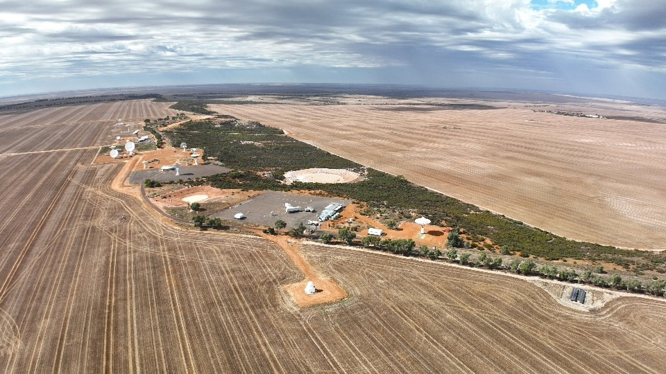
A drone shot of the Yarragadee Geodetic Observatory. Credit: Robert Nugent - Geoscience Australia Artist in Residence 2023
Out in the West Australian desert at Yarragadee Geodetic Observatory station, Geoscience Australia scientists are shooting high-powered lasers at satellites flying thousands of kilometres overhead.
Known as Satellite Laser Ranging (SLR), this activity measures the Earth’s centre of mass and is one of four crucial space geodesy activities that makes the Yarragadee Geodetic Observatory (YGO), located more than 300 kilometres north of Perth, a “geodetic supersite”.
“Geodesy,” said National Geodesy Director Nick Brown, is “the science of the measuring the Earth”.
There are huge forces interacting with Earth as it flies through the universe.
Geoscience Australia, as the nation’s leading Earth science organisation, works with a range of international partners to track the many constant changes occurring within and around the rock we call home.
“The Earth is dynamic,” Nick added.
“It is hurtling through space in orbit around the Sun and being pulled in various directions by the Moon and other planets. This complex relationship causes the surface of the oceans and Earth to rise and fall over time.”
Knowing the relationship between satellites and the Earth is critical to Positioning, Navigation and Timing (PNT) technology, which makes the geodetic observations from Yarragadee crucial to our daily lives.
Nick explained that geodesy underpins numerous PNT applications “like precision agriculture, smart phone applications, improved weather predictions, disaster modelling, navigation assistance for the blind, as well as synchronising our power grid and financial transactions”.

The Yarragadee Geodetic Observatory near Dongara, WA is an internationally vital site. This satellite Laser Ranging equipment that uses lasers to locate satellites to measure their distance from the Earth down to millimetre-level precision. This provides data about the shape, orientation and speed of the Earth. Image credit: Geoscience Australia
Yarragadee’s laser, the NASA MOBLAS-5, hits its satellite targets with the speed and precision necessary to measure where Earth is in time and space, enhancing these PNT technologies.
MOBLAS-5 – ironically meaning “Mobile Laser 5” – has sat at Yarragadee since October 1979.
It was once supposed to move to Darwin in the Northern Territory, but Yarragadee station manager Randall Carman said that a move would cause an unnecessary loss of data, as SLR instruments would need to be co-located and recalibrated over a whole year.
“It would take months to set up and relocate or strip down, then relocate, and then set up again,” Randell said.
“Unless you can set up quickly, you're going to lose some of your continuity of your baseline data, especially the most productive station in the whole network.
“So these MOBLAS systems more or less became fixed stations. The science always wins out.”
There are currently five stations in the 2nd generation MOBLAS network, with two in the continental United States, one in South Africa, one in Tahiti and Australia’s MOBLAS-5, which consists of three vans, a support building and an antenna on a hectare of bitumen.
These stations sit under clear skies and “near perfect weather” to allow them to make measurements to orbiting satellites.
The equipment, which is maintained to NASA standards, includes computers that despite operating for 25 years still enable Yarragadee to be the best performing SLR station in the world.
The Yarragadee supersite is home to many other geodetic infrastructures that offer services such as:
- Very Long Baseline Interferometry: which measures the Earth’s spin rate, its shape, and time with extremely high precision.
- Three Global Navigation Satellite System sites: which measure signals from GPS and other satellite navigation systems to measure the position and motion of the Earth's crust over time, providing real-time corrections for people to accurately position themselves and navigate.
Randall said that for the celestial push and pull to be accurately gauged there are international cooperative bodies working together to ensure that “all the lasers, all the ranging services, and all the geodesy services are constantly striving to improve our precision and our accuracy, whilst making sure we don't have biased data. This allows us to make sure that we're producing the best reference frame we can”.
As part of this global effort, these organisations measure constant fluctuations in sea surface height or land surface height.
“What are the oceans doing? How much are they rising?” Randall said.
“SLR is critical for measuring how thick the ice sheets are, as well as recording the movements that occur in the Earth’s subsurface due to the gravitational pull of the Sun and Moon.
“Also known as tides of the solid Earth, the gravitational pull from these Celestial bodies cause the Earth’s surface to move by up to 55 centimetres over a 24-hour period.”
To achieve an accurate reading, operators need to know where a satellite is in relation to the centre of the Earth.
“The process is two-pronged,” said Randall.
“You're working out where the satellites are, but at the same time you’re working out what the terrestrial reference frame is, so the satellites can know where they are as well.”
In a testament to that consistent precision, Geoscience Australia has signed an extension to its agreement with NASA to continue their collaboration on space geodetic research at Yarragadee.
Nick Brown praised Yarragadee scientists for their industriousness in maintaining peak international standards on aged equipment.
“We have a great collaboration with NASA who own the SLR equipment we operate, and they help us keep it running,” he said.
“But the Geoscience Australia staff, the people who work at Yarragadee, do an amazing job to maintain this infrastructure and keep it operating. They are like modern day McGyvers.”