Australia's Coasts and Estuaries
Page last updated:29 April 2021
Coasts and estuaries form a dynamic, transition zone between the land and the sea and help Australians achieve many economic, social and environmental benefits. The Australian coastline extends approximately 34 000 kilometres (excluding all small offshore islands) and includes more than 1000 estuaries. Approximately 50 per cent of the Australian population resides within seven kilometres of the coast and ports and other coastal infrastructure are pivotal in supporting primary industries and tourism.
Managing coasts and estuaries is becoming ever more important given the increasing nature of pressures such as:
- population growth and urbanisation
- coastal catchment development
- climate change
The management of coastal resources is largely the responsibility of the States and Northern Territory, but the Australian Government also has responsibilities for many coastal issues, including defining maritime boundaries, overseeing national conservation goals and maritime safety. Geoscience information is aiding State and Commonwealth managers make decisions regarding coastal management issues by providing the broad spatial context in which coastal processes operate and geomorphology can be classified.
Geoscience Australia supports decision making and coastal management by:
- providing free national data about Australia’s 33,000 kilometres of coasts, identifying annual shorelines and rates of coastal change from 1988 to the present (DEA Coastlines)
- compiling and making available baseline and condition assessment data, fact sheets, maps and decision support tools through the national coastal information system (via the Ozcoasts web site)
- assessing water and sediment quality through nationally significant case studies in collaboration with its external partners
- assessing the coastal geomorphology and shoreline changes in relation to climate change impacts (Landform and Stability maps - OzCoasts web site)
- developing physical surrogates of biodiversity that can be mapped and developing predictive models of coastal processes which rely on physical and biological data
- working with Australian Government and state emergency management and planning agencies to be better prepared for a range of hydrodynamic hazards such as tsunami, storm surge and flooding
- defining national jurisdiction zones and advising government agencies on the definition of administrative zones within the national maritime jurisdiction
- developing environmental monitoring products using remotely sensed data including time series analysis of sediment plumes and concentrations resulting from dredging operations, and time series of greenness to assess the condition of mangroves and estuarine wetlands
- developing shallow water bathymetry models using remotely sensed data to contribute to areas such as inundation hazard modelling, benthic habitat mapping and coastal vulnerability assessment
- studying physical processes in coastal aquifers, such as seawater intrusion and the results on the health of groundwater dependent ecosystems, and assessing the potential impacts of groundwater extraction.
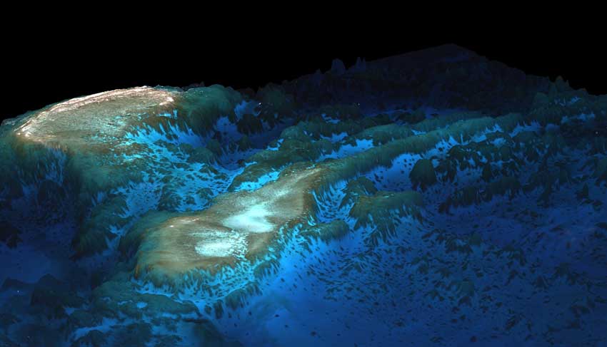
Shallow water bathymetry model developed by physics-based remote sensing techniques applied to Quickbird satellite data.