Deep dives Delamerian project
Page last updated:29 September 2026
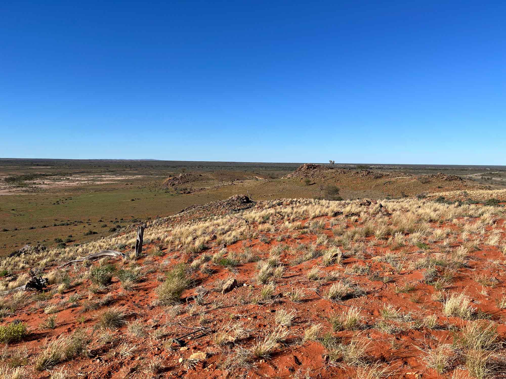
Packsaddle, New South Wales, Malyangapa Country. Image by Yanbo Cheng.
Geoscience Australia acknowledges the First Nations peoples, Traditional Custodians, landholders and communities of the Delamerian region.
- CHENG, Y., GILMORE, P., DOUBLIER, M., CZARNOTA, K., LEWIS, C., TAYLOR, H., CLARK, A., PITT, L., MOLE, D., WANG, Y., MEFFRE, S., BROTODEWO, A., CAYLEY, R., CAIRNS, C., BURNHAM, A., WISE, T. (preprint). Interplay between supercontinents and accretionary orogens recorded in 200 million years of metallogeny, EarthArXiv.
- LESTER, J.E. EVANS, T., MARSHALL, S.K., BARRATT, U., KILGOUR, P.L., BUSH, A.L., BUCHANAN, S., JOB, K., DORJI, C. AND CAREY, H. (2026) Groundwater Systems of the Delamerian Region – Hydrogeology of the Murray, Otway and Troubridge basins and the Delamerian Orogen fractured rock. Geoscience Australia.
- TAYLOR, H., CHENG, Y., MOLE, D., CLARK, A. (2026). A magma fertility study: Porphyry copper potential of the Delamerian Orogen. Geoscience Australia.
- EVANS, T. (2026). Victorian Groundwater Bores Summary. Geoscience Australia.
- EVANS, T., PELJO, M. (2026). Delamerian region digitised geophysical wireline well log data. Geoscience Australia.
- KILGOUR, P.L., DORJI, C., MARSHALL, S.K., LESTER, J., JOB, K., EVANS, T. (2026). Delamerian Groundwater Map Series - Groundwater Systems of the Delamerian Region, Murray Basin and Otway Basin. Geoscience Australia.
- LESTER, J., EVANS, T., SHANMUGAM, S., MARSHALL, S.K. (2026). Delamerian Groundwater Bore Compilation, Aquifer Attribution and Hydrographs. Geoscience Australia.
- ROLLET, N., NORTON, C. J., HANNAFORD, C., BISHOP, C., EVANS, T. (2026). Murray Basin and underlying pre-Cenozoic stratigraphy and hydrostratigraphy, Compilation of existing and new biostratigraphic and borehole data in a sequence stratigraphic framework. Record 2026/20. Geoscience Australia.
- EVANS, H., S., WOODS, M. (2026). GIS dataset from the Murray Basin Hydrogeological Map series. Geoscience Australia.
- RAY, A., MCPHERSON, A., BRODIE, R.C., ET AL. (2026). A Decade of Airborne Electromagnetic Surveying Lake Menindee (Australia) Under Varying Water Levels. Geophysical Prospecting Vol 74 (4), e70171.
- JIANG, W., DOUBLIER, M., VIZY, J., HITCHMAN, A., BRODIE, R. (2026). Probabilistic inversion of high-frequency magnetotelluric data for cover thickness estimation in the Curnamona-Delamerian region. Geoscience Australia.
- EVANS, T., HOSTETLER, S., WOODS, M. (2026). GIS dataset from Hydrogeology of the Darling River Drainage Basin 1995 map series. Geoscience Australia.
- GORBATOV, A. (2025). Morphology of the Moho discontinuity in the Delamerian Zone. Geoscience Australia.
- DUAN, J., WINTLE, C., MAHER, P., TAYLOR, G., MATTHEWS, S. (2025). Lithospheric resistivity structures from AusLAMP data in New South Wales and Victoria. Geoscience Australia.
- HEJRANI, B. (2025). Surface-wave Velocity Mapping of the Delamerian Region. Geoscience Australia.
- CLOUTIER, J., FORD, A., HUSTON, D., HAYNES, M., SCHOFIELD, A., DOUBLIER, M., SANCHEZ, G., DUAN, J., GOODWIN, J., BEYER, E., FRASER, G., CHENG, Y., WALTENBERG, K., BURNHAM, A., CZARNOTA, K. (2025) 2025 Iron oxide copper-gold potential of Australia using a hybrid data- and knowledge-driven approach and its implications for the formation of IOCG mineral systems. Ore Geology Reviews Vol 185 (2025).
- WISE, T., DOUBLIER, M., PREISS, W., PAWLEY, M., THIEL, S., KRAPF, C., ABDULLAH, R., WADE, C., MILLER, R., COSTELLOE, R., HOSSAIN, M., RASHEED, H., NICOLL, M. (2025) Basins and Ranges. A cross-section through sedimentation and tectonism along the Delamerian-Lachlan deep crustal seismic line 22GA-DL1. Departmental Publication - MESA Journal. Government of South Australia.
- MOLE, D. R., BODORKOS, S., BOGER, S.D., CAIRNS, C.P., LIEBMANN, J., CAYLEY, R.A. (2025). A geochronological transect across the Tasmanides: New U-Pb zircon ages for Victorian granites. Geoscience Australia.
- BONNARDOT, M.-A., GROSE, L., WILFORD, J., DU, Z., HOPE, J., WONG, S.C.T., VIZY, J., ROLLET, N. (2025) EFTF cover thickness model in the Darling-Curnamona-Delamerian (DCD) region. Geoscience Australia.
- GEOSCIENCE AUSTRALIA (2025). Cover Models in the Darling-Curnamona-Delamerian WCS. Geoscience Australia.
- GEOSCIENCE AUSTRALIA (2025). Cover Models in the Darling-Curnamona-Delamerian WMS. Geoscience Australia.
- GEOSCIENCE AUSTRALIA (2025). Cover Models in the Darling-Curnamona-Delamerian WMTS. Geoscience Australia.
- GILMORE, P. J., BODORKOS, S., LEWIS, C.J., PITT, L., CLARK, A.D., CHENG, Y., MOLE, D.R., DOUBLIER, M.P., TAYLOR, H.L., ROACH, I.C. (2025). The Delamerian Orogen on mainland Australia plotted in time and space. Geoscience Australia.
- CHENG, Y. (2025). Delamerian Metallogeny: Concept, Minerals Systems and Exploration. Geoscience Australia.
- MOLE, D., LEWIS, C., BODORKOS, S., CROWLEY, J., SCHOFIELD, A., CURTIS, S., EVANS, N. (2025). A slab origin for low-δ18O arc magmas. Geology Vol 53 (4), 311-316.
- BOREHAM, C., CZADO, K., TAYLOR, G., BLACK, E. (2024). Soil gas surveys for hydrogen and helium in New South Wales. Geoscience Australia.
- BONNARDOT, M., GROSE, L., WILFORD, J., DU, Z., HOPE, J., WONG, S., VIZY, J., ROLLET, N. (2024). Unearthing Australia’s subsurface secrets - An integrated FAIR modelling approach. Geoscience Australia.
- JIANG, W., A. CLARK, Y. CHENG, M. DOUBLIER, A. HITCHMAN, AND J. DUAN. (2024). Unveiling electrical resistivity structures along the undercover Delamerian Orogen, Southeast Australia. Geoscience Australia.
- TAYLOR, H., A. CLARK, P. GILMORE, D. MOLE, A. SCHOFIELD, Y. CHENG, I. SCHRODER, L. PITT, AND M. DOUBLIER. (2024). A geochemical characterisation of the Loch-Lilly Kars Belt in the Delamerian Orogen. Geoscience Australia.
- CLARK, A. D., P. J. GILMORE, D. R. MOLE, Y. CHENG, W. JIANG, M. P. DOUBLIER, H. TAYLOR, L. PITT, C. LEWIS, I. ROACH, G. SANCHEZ, M. THOMAS, AND A. BUDD. (2024). Cambrian convergent margin configuration in the Delamerian Orogen of mainland Australia. Geoscience Australia.
- CLARK, A., PITT, L., DOUBLIER, M., HIGHET, L., MOLE, D., TAYLOR, H., WISE, T., GILMORE, P.J., HARTNADY, M., KIRKLAND, C.L., BARULEVA, O., LEWIS, C.J., THOMAS, M., FOLKES, C., COLQUHOUN, G.P., CHENG, Y., ROACH, I.C., BUDD, A. (2024). Basement geology of the Loch Lilly-Kars Belt, Lake Wintlow Belt, and Wilcannia High. Geoscience Australia.
- BUCKERFIELD, S., MCPHERSON, A., TAN, K., WALSH, C., KILGOUR, P., BUCHANAN, S., RAIBER, M., SUCKOW, A., PINCUS, J., SYMINGTON, N., PELJO, M., RAY, A., BRODIE, R.C. (2024). Groundwater systems of the upper Darling-Baaka River floodplain, New South Wales. Geoscience Australia.
- CHENG, Y., P. GILMORE, C. LEWIS, I. ROACH, A. CLARK, D. MOLE, L. PITT, M. DOUBLIER, G. SANCHEZ, A. SCHOFIELD, A. O'ROURKE, A. BUDD, D. HUSTON, K. CZARNOTA, S. MEFFRE, S. FEIG, R. MAAS, S. GILBERT, C. CAIRNS, R. CAYLEY, T. WISE, C. WADE, M. WERNER, C. FOLKES, AND K. HUGHES. (2024). Mineral systems and metallogeny of the Delamerian Orogen margin. Geoscience Australia.
- DOUBLIER, M., A. CLARK, R. J. KORSCH, R. MILLER, P. GILMORE, C. FOLKES, L. MAHONEY, R. ABDULLAH, R. CAYLEY, Y. CHENG, G. FRASER, W. JIANG, C. KRAPF, M. MCLEAN, D. MOLE, M. NICOLL, P. SKLADZIEN, S. THIEL, C. WADE, T. WISE, H. RASHEED, M. HOSSAIN, AND R. COSTELLOE (2024). Crustal architecture along seismic line 22GA-CD2 new insights from the Darling-Curnamona-Delamerian deep seismic reflection survey. Geoscience Australia.
- REID, N., SCHRODER, I., THORNE, R., FOLKES, C., HORE, S., EASTLAKE, M., PETTS, A., EVANS, T., FABRIS, A., PINCHAND, T., HENNE, A., PALOMBI, B.R. (2024). Hydrogeochemistry of the Curnamona and Mundi region. Geoscience Australia.
- CLOUTIER, J., FORD, A., HUSTON, D., HAYNES, M., SCHOFIELD, A., DOUBLIER, M., SANCHEZ, G., DUAN, J., GOODWIN, J., RICHARDS, S., BEYER, E., CHAMPION, D., MORFIADAKIS, A., FRASER, G., CHENG, Y., WALTENBERG, K., BURNHAM, A., CZARNOTA, K. (2024). First national mineral system assessment of Australia's iron oxide copper-gold potential. Geoscience Australia.
- TAN, K., DILLON, P., BUCHANAN, S., MCPHERSON, A., BUCKERFIELD, S., KILGOUR, P., WALSH, C. (2024). Preliminary assessment of the managed aquifer recharge potential in the Wilcannia region, northwest New South Wales. Record 2024/28. Geoscience Australia.
- MCPHERSON, A., BUCKERFIELD, S., TAN, K., WALSH, C., KILGOUR, P., BUCHANAN, S., RAIBER, M., SUCKOW, A., PINCUS, J., SYMINGTON, N., PELJO, M., RAY, A., BRODIE, R.C. (2024). Geological and hydrogeological investigations of the Upper Darling River Floodplain, northwest New South Wales. Record 2024/29. Geoscience Australia.
- PELJO, M., TAN, K., SYMINGTON, N., DEGRAAF, R., SPULAK, R. (2024). EFTF Upper Darling Floodplain Downhole and surface geophysics data release. Geoscience Australia.
- WALSH, C., BUCKERFIELD, S., RAIBER, M., SUCKOW, A. (2024). Upper Darling Floodplain hydrochemistry data. Geoscience Australia.
- MOLE, D., CLARK, A., BODORKOS, S., LEWIS, C. (2024). New U-Pb SHRIMP zircon geochronology from NDI drilling of the Delamerian Orogen: Loch-Lilly-Kars and Lake Wintlow Belts, southwest NSW. Geoscience Australia.
- FOSS, C. A., HOPE, J., PATABENDIGERADA, S. (2024). Regional magnetic depth estimates for Eastern Resources Corridor (ERC), Officer Basin, Tasmania and Northeast Queensland. Geoscience Australia.
- HOPE, J., WONG, S., FOSS, C. A., BUDDEE, M., SANCHEZ, G., BONNARDOT, M. (2024). Regional magnetic depth estimates for Eastern Resources Corridor (ERC), Officer Basin, Tasmania and Northeast Queensland - Interpretation Data Package. Geoscience Australia.
- YU, J., GLORIE, S., HAND, M., SIMPSON, A., GILBERT, S., SZILAS, K., ROBERTS, N., PAWLEY, M., CHENG, Y. (2024). Laser ablation (in situ) Lu-Hf geochronology of epidote group minerals. Contributions to Mineralogy and Petrology Vol 179 (62).
- CHENG, Y., PHIL GILMORE, LEWIS, C., ROACH, I., DOUBLIER, M., PITT, L., CLARK, A., SCHRODER, I., TAYLOR, H., BUDD, A., THOMAS, M., WELLS, J., HUSTON, D., SCHOFIELD, A., OROURKE, A., MEFFRE, S., FEIG, S., CAIRNS, C., CAYLEY, R., WISE, T., WADE, C., WERNER, M., HUGHES, K., FOLKES, C. (2024). Metallogenic characteristics of key mineral prospects in the Delamerian Orogen, Australia. Geoscience Australia.
- MOLE, D., BODORKOS, S., GILMORE, P.J., FRASER, G., JAGODZINSKI, E.A., CHENG, Y., CLARK, A.D., DOUBLIER, M., WALTENBERG, K., STERN, R.A., EVANS, N.J. (2023). Architecture, evolution and fertility of the Delamerian Orogen: Insights from zircon. Geoscience Australia.
- PITT, L., I. ROACH, A. BUDD, A. CLARK, H. TAYLOR, C. LEWIS, P. J. GILMORE, M. SUTTI, M. THOMAS, J. WELLS, M. DOUBLIER, Y. CHENG, I. SCHRODER, A. SCHOFIELD, AND A. O’ROURKE. (2023). Delamerian Margins National Drilling Initiative - Summary of field data acquisition. Geoscience Australia.
- PITT, L., ROACH, I., BUDD, A., CLARK, A., TAYLOR, H., LEWIS, C., GILMORE, P.J., SUTTI, M., THOMAS, M., WELLS, J., DOUBLIER, M., CHENG, Y., SCHRODER, I., SCHOFIELD, A., OROURKE, A. (2023). Delamerian Margins NSW National Drilling Initiative campaign – Summary of field data acquisition. Record 2023/46. Geoscience Australia.
- MCPHERSON, A., BUCKERFIELD, S., TAN, K., KILGOUR, P., BUCHANAN, S. (2023). Exploring for the Future—Upper Darling River Floodplain, northwest New South Wales: context report. Geoscience Australia.
- SCHRODER, I., H. TAYLOR, D. CHAMPION, M. DOUBLIER, P. GILMORE, A. CLARK, P. MAIN, Y. CHENG, P. ASHLEY, C. CAIRNS, R. CAYLEY, J. BYASS, S. GILMORE, AND I. LONG (2023). Rock geochemistry from the Curnamona Province and Delamerian Orogen. Geoscience Australia.
- BUCKERFIELD, S., KILGOUR, P., CASTELLAZZI, P., DABOVIC, J., MCPHERSON, A., DIXON-JAIN, P., SYMINGTON, N., BUCHANAN, S. (2023). Groundwater dependent ecosystem assessment using remote sensing. Exploring for the Future - Upper Darling River floodplain, New South Wales. Geoscience Australia.
- KILGOUR, P., SYMINGTON, N. (2023). Groundwater dependent ecosystems in the upper Darling River floodplain NSW, mapped using Landsat satellite data. Geoscience Australia.
- PITT, L., I. ROACH, A. BUDD, H. TAYLOR, A. CLARK, M. SUTTI, M. THOMAS, J. WELLS, AND C. LEWIS. (2023). Delamerian Margins National Drilling Initiative campaign field data. Geoscience Australia.
- JIANG, W., DUAN, J., KYI, D., HITCHMAN, A. (2023). Resistivity Model Derived from Magnetotelluric Data in the Curnamona and Delamerian Region. Geoscience Australia.
- DE CARITAT, P., PETTS, A., KELAART, C. (2023). Contribution Towards a Regolith Mineralogy Map of the Australian Continent A Study in South Australia, Queensland and the Northern Territory. Geoscience Australia.
- WONG, S. C. T., HEGARTY, R.A., PITT, L., CROWE, M.C., ROACH, I., NICOLL, M., LEYCOOPER, Y., HOPE, J., BONNARDOT, M. (2023). Eastern Resources Corridor Airborne Electromagnetic Interpretation Data Package. Geoscience Australia.
- HANNAFORD, C., ROLLET, N. (2023). Palynological data review of selected boreholes in the Great Artesian, Lake Eyre basins and Upper Darling Floodplain (part 2) ‒ Infilling data and knowledge gaps. Geoscience Australia.
- NORTON, C.J., ROLLET, N. (2023). Regional stratigraphic correlation transects across the Great Artesian, Lake Eyre basins and Upper Darling Floodplain region (part 2) ‒ Infilling data and knowledge gaps. Geoscience Australia.
- JIANG, W., KYI, D., DUAN, J., HITCHMAN, A. (2023). Curnamona Cube Extension Magnetotelluric (MT) Survey - Data Package. Geoscience Australia.
- FOMIN, T., COSTELLOE, R., HOSSAIN, M. (2023). L213 Darling-Curnamona-Delamerian (DCD) 2D Seismic Survey. Geoscience Australia.
- GEOSCIENCE AUSTRALIA (2023). Darling, Curnamona, Delamerian AEM Survey: Logistics Report, AEM Data, and Inversion Results. Geoscience Australia.
- TAYLOR, H., SCHRODER, I.F., MAIN, P.T., CHAMPION, D.C., EVANS, T. (2022). Curnamona Geochemistry Compilation. Geoscience Australia.
- KIRKBY, A., DOUBLIER, M. (2022). Synthetic magnetotelluric modelling of a regional fault network – implications for survey design and interpretation. Australian Society of Exploration Geophysicists. Vol 55 (Sept. 2024), 617 – 628.
- RAY, A. (2022). Upper Darling Floodplain, New South Wales, Airborne Electromagnetic Survey. Geoscience Australia.
- BUCKERFIELD, S., MCPHERSON, A., TAN, K., KILGOUR, P., BUCHANAN, S. (2022). Upper Darling Floodplain groundwater resource assessment. Geoscience Australia.
- DE CARITAT, P., E. BASTRAKOV, A. T. WALKER, AND B. I. A. MCINNES (2022). The Heavy Mineral Map of Australia Project -- Data Release 1: The Darling-Curnamona-Delamerian Region. Geoscience Australia.
- DE CARITAT, P., KIRSTE, D., DANN, R., EVANS, T., SCHRODER, I., MAIN, P. (2022). Broken Hill groundwater and regolith geochemistry (1999-2005). Geoscience Australia.
- DE CARITAT, P., TROITZSCH, U. (2021). Towards a Regolith Mineralogy Map of the Australian Continent - A Feasibility Study in the Darling-Curnamona-Delamerian Region. Geoscience Australia.
- BRODIE, R. (2021). MinEx CRC Mundi Airborne Electromagnetic Survey, NSW, 2021: XCITE® AEM data and conductivity estimates. Geoscience Australia.
- WALTENBERG, K., JONES, S., DUNCAN, R., WAUGH, S., LANE, J. (2021). Isotopic Atlas of Australia: Geochronology compilation for Victoria. Geoscience Australia.
- LEYCOOPER, Y. (2021). Exploring for the Future AusAEM Eastern Resources Corridor: 2021 Airborne Electromagnetic Survey TEMPEST® airborne electromagnetic data and GALEI inversion conductivity estimates. Geoscience Australia.
- ROBERTSON, K., KIRKBY, A.L., THIEL, S., DUAN, J. (2020). Lithospheric resistivity model of the Delamerian Orogen from AusLAMP magnetotelluric data. Geoscience Australia.
The Delamerian project was established to address a key gap in Australia’s understanding of the geological evolution and resource potential of south-eastern Australia. Spanning across New South Wales, South Australia, Tasmania and Victoria, the region has unrealised potential for gold, copper and other critical mineral resources that can support Australia’s net zero transition. The region also hosts significant groundwater systems that support regional development, agriculture, environmental values and communities across the western Murray Basin and upper Darling River Floodplain.
Supported initially through Geoscience Australia’s Exploring for the Future program and completed as the first regional deep dive under Resourcing Australia’s Prosperity, the project provided a unique opportunity to examine the Delamerian region as a single geological province and reveal the region’s resource potential. Read the summary report now: Delamerian Project: Achievements Report.
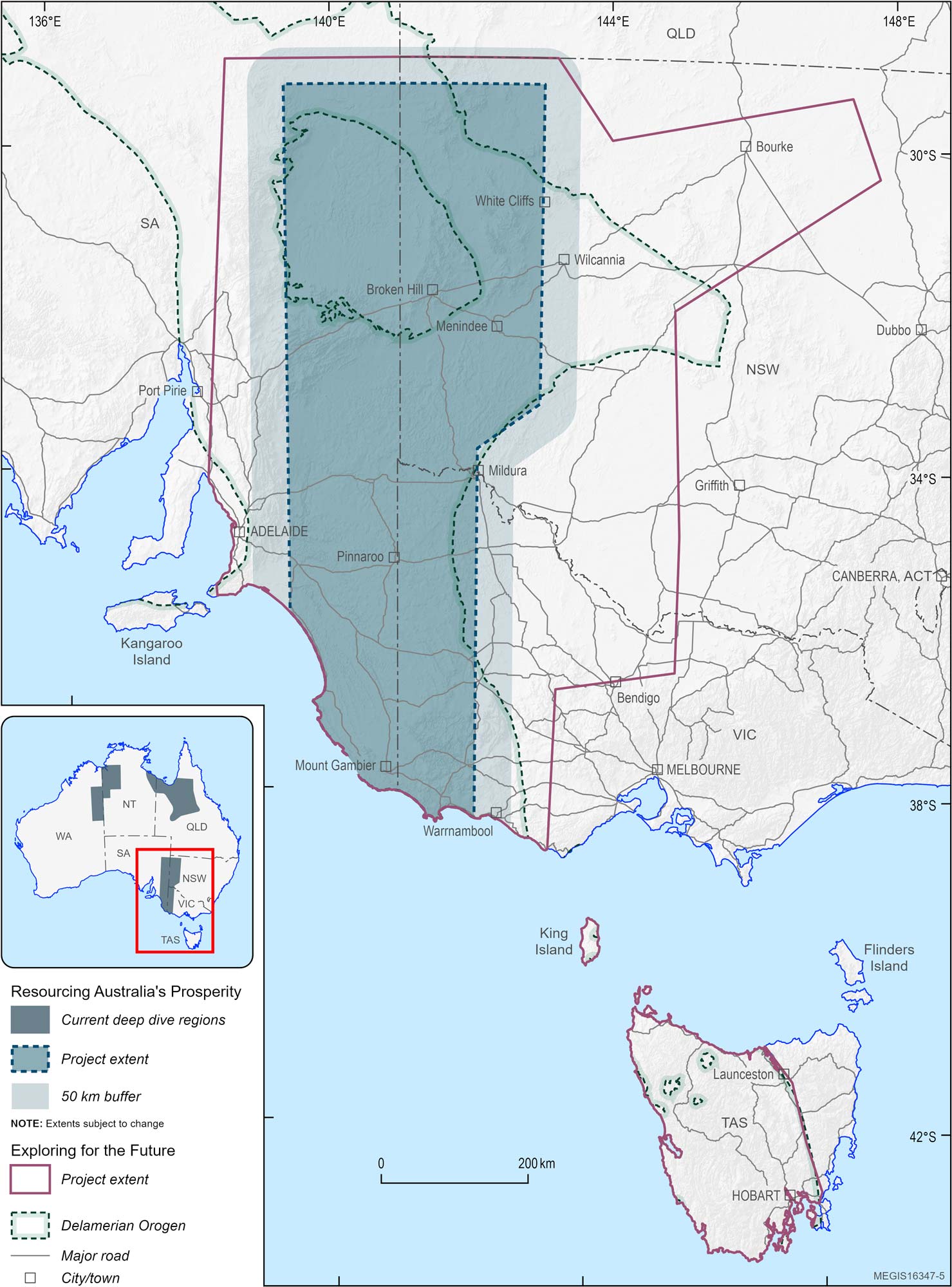
Location of the Delamerian project study area under Exploring for the Future and Resourcing Australia’s Prosperity.
What we found
The Delamerian project delivered a step change in our understanding of one of Australia’s most prospective yet under-explored geological regions, achieving major scientific and practical outcomes with regional and national impact.
Key findings for Australia:
- Continuous Delamerian arc extending more than 1,000 km beneath south-eastern Australia
- New understanding of geological controls on mineral prospectivity across the region
- Exploration corridors defined for future copper, gold and critical mineral discovery
- Evidence for economically viable mineral systems across several belts
- Improved understanding of groundwater systems supporting communities, industry and the environment
- Potential managed aquifer recharge target areas identified near Wilcannia
Click through the dropdown menus below to find out more.
- Identified strong evidence for a continuous convergent margin system extending over 1,000 km, providing industry with greater confidence to explore for the right types of mineral deposits that can be formed in these specific geological environments.
- Demonstrated that specific parts of the Delamerian convergent margin are more favourable for different types of mineralisation with diverse potential for different commodities, including critical minerals.
- Delivered the most complete understanding to date of the region’s deep geological architecture and evolution, a key control on where mineral deposits form.
- Crustal architecture along seismic line 22GA-CD2 new insights from the Darling-Curnamona-Delamerian deep seismic reflection survey
- Unveiling electrical resistivity structures along the undercover Delamerian Orogen, southeast Australia
- Cambrian convergent margin configuration in the Delamerian Orogen of mainland Australia
- The Delamerian Orogen on mainland Australia plotted in time and space
- Defined four major metallogenic events, linked to known deposit types including copper, gold, zinc and nickel.
- Provided new clarity on the distribution and depth of buried rocks, helping explorers better plan drilling and investment.
- Mapped new exploration ‘fairways’ , focusing attention on the most prospective areas and reducing the search space.
- Produced a new, integrated picture of groundwater systems across the region, including the western Murray Basin.
- Improved baseline knowledge of groundwater availability, quality and connectivity, to support better long-term management.
- Delivered information to communities, agriculture and industry that rely on groundwater in a low-rainfall environment.
- Groundwater Systems of the Delamerian Region – Hydrogeology of the Murray, Otway and Troubridge basins and the Delamerian Orogen fractured rock
- Geological and hydrogeological investigations of the Upper Darling River Floodplain, northwest New South Wales
- Preliminary assessment of the managed aquifer recharge potential in the Wilcannia region, northwest New South Wales
The big picture
The Delamerian project has leveraged new data and interpretations to build a new understanding of the geology of the region and its potential to host a range of resources.
Click the accordions below to see the types of data analysed and evidence collected.
- 57,101 line-kilometres of airborne electromagnetic (AEM) data
- 1,256 km of 2D reflection seismic
- 17 drill holes, totalling 5,158 metres
- 99 magnetotelluric (MT) sites
- 152 geochronology ages
- New regional groundwater, hydrochemical and hydrological datasets
- 6.5 million geochemical data points
- 143 petrological samples characterised
- 2 time-space plots
- 753 passive seismic stations integrated and modelled
- 231 integrated MT sites creating high-resolution crustal resistivity model
- 43,000 line-kilometres of AEM data modelled
- 30,000 line-kilometres of AEM data interpreted
- 1,494 line-kilometres of 2D reflection seismic interpretation
- 22 mineral deposits and prospects characterised
- 4 mineralisation events identified
- 4 regional depth surface grids, 4 isochore grids and 1 machine-learning Cenozoic surface
- 294 groundwater samples integrated to reveal water rock interactions
- First cross-jurisdictional hydrological review of the western Murray Basin in more than 30 years
- Geology and cover-thickness mapped across 300,000 km²
What we did
The Delamerian project brought together multiple geoscience disciplines to investigate the region, from the surface to deep within the Earth. By collecting new data and integrating it with existing datasets, the project built a comprehensive, multi-layered understanding of the Delamerian region. Click through the dropdown menus below to learn more about what we investigated.
- Conducted deep crustal 2D seismic reflection surveys traversing 3 states (New South Wales, South Australia and Victoria). This new reflection seismic data provided evidence to redefine the tectonostratigraphic framework of the Delamerian region.
- Used a combination of reflection seismic, passive seismic and magnetotelluric methods and models to map major faults, crustal boundaries and concealed rock systems beneath sediment cover.
- Applied high precision zircon uranium-lead (U-Pb) geochronology to unravel the temporal-spatial evolution of the Delamerian convergent margin, including the basement rock samples from the MinEx CRC Delamerian Margin National Drilling Initiative.
- Used whole rock geochemistry, zircon trace elements, zircon Hf and O isotopes of magmatic rocks to reconstruct the geological history and tackle the evolution and development of the Delamerian convergent margin.
- Refined and advanced a 3D hydrogeological representation and an accompanying comprehensive report on groundwater systems across the Delamerian region. This encompasses the western Murray, Otway and Lake Eyre basins, as well as Delamerian Orogen fractured rock aquifers.
- Collected new groundwater data to address spatial and knowledge gaps in key aquifers which support agricultural, environmental and industrial applications.
- Compiled a regional hydrological inventory of aquifers, groundwater levels and water quality.
- Integrated legacy and new multi-disciplinary data to deliver new understanding of the temporal and spatial geodynamic evolution of the Delamerian region over 200 million years of geological history reflecting the events that shaped south-eastern Australia.
- Developed time sliced tectonic models for the key stages of the Delamerian Orogen evolution.
- Established a tectono-metallogenic framework for the Delamerian convergent margin system.
- Delivered the integrated insights into the timing, geological drivers, and governing controls of major mineralisation events, clarifying the strategic potential for copper, gold, zinc, molybdenum, critical minerals, and broader resource opportunities.
- Systematically characterised known mineral deposits and prospects across the Delamerian orogen, paving the path for regional mineral exploration and discoveries.
Collaboration
- Geological Survey of South Australia
- Geological Survey of New South Wales
- Geological Survey of Victoria
- MinEx CRC
- Australian National University
- University of Tasmania
- Adelaide University
- University of Melbourne
- South Australian Department for Environment and Water
- Victorian Department of Energy, Environment and Climate Action
- New South Wales Department of Climate Change, Energy, the Environment and Water
- Murray–Darling Basin Authority
- NSW Department of Primary Industries and Regional Development
- Curtin University
- University of Alberta
Further information
All data produced by Geoscience Australia, including the data from this project, is publicly available after quality assurance has been performed.
For more information, copies of our precompetitive data or general enquiries, please email clientservices@ga.gov.au or call 1800 800 173.
Geoscience Australia activities are not undertaken on behalf of any exploration company; we work for the benefit of all Australians.
Delamerian project summary outputs
Resourcing Australia's Prosperity - diving deep in the Delamerian
This webinar summarises the Delamerian project, the first regional deep dive to be completed under Resourcing Australia’s Prosperity.
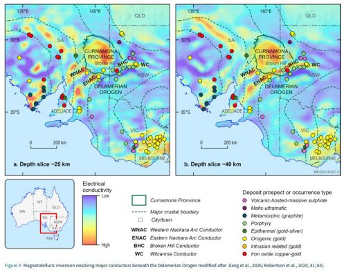
Delamerian Project: Achievements Report
Read about the Delamerian project findings in the Achievements Report.
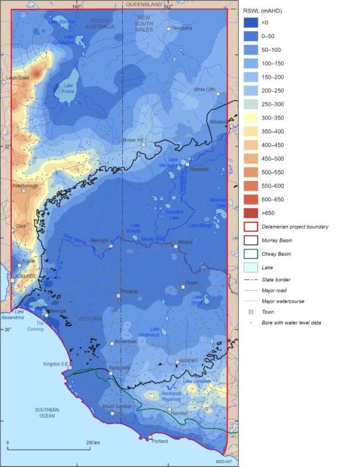
Groundwater Systems of the Delamerian Region
The Delamerian Groundwater Project provides a regional-scale synthesis of groundwater systems across a large cross-jurisdictional area spanning New South Wales, South Australia and Victoria, a region that has recognised potential for critical minerals, energy resources and geological storage.
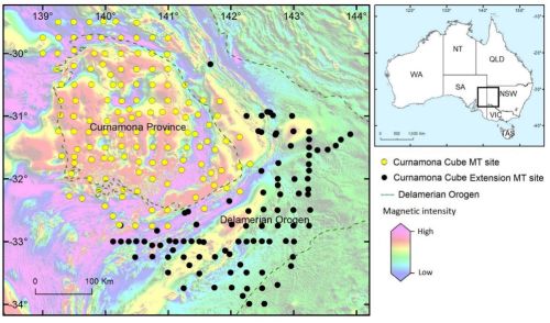
Probabilistic inversion of high-frequency magnetotelluric data
We applied a probabilistic approach to inverting high frequency magnetotelluric (MT) data collected by two recent surveys in the Curnamona-Delamerian Region: the Curnamona Cube survey by the University of Adelaide/AuScope and the Curnamona Cube Extension survey by Geoscience Australia.